Gulf of Guinea factor on Cape Verde activity

This is the general tropical discussion area. Anyone can take their shot at predicting a storms path.

Moderator: S2k Moderators

Forum rules

The posts in this forum are NOT official forecasts and should not be used as such. They are just the opinion of the poster and may or may not be backed by sound meteorological data. They are NOT endorsed by any professional institution or STORM2K. For official information, please refer to products from the National Hurricane Center and National Weather Service.

Help Support Storm2K
Message
Author
User avatar
cycloneye
Admin
Admin
Posts: 145370
Age: 68
Joined: Thu Oct 10, 2002 10:54 am
Location: San Juan, Puerto Rico

Gulf of Guinea factor on Cape Verde activity

#1 Postby cycloneye » Fri Jun 10, 2011 11:11 am

I gather that many peeps dont know a lot or nothing about the Gulf of Guinea located in West Africa and how it affects the tropical cyclone activity in the Tropical Atlantic. That is why I decided to make this thread for the members to know more about how the Gulf of Guinea can be an important factor on how active or not the CV seasons may be. The thing is that when it turns cool,then the ITCZ lifts more northward than normal and the Sahel region moists up causing the tropical waves to be stronger as they emerge the African coast, Also, the cooling of the Gulf causes less sal events that causes the CV season to be active, again, because of the moist Sahel. Last year, the western Sahel was very wet and that is likely contributing to increased soil moisture and less dust so far in 2011. On the contrary,when the Gulf of Guinea warms,the effect is to cause the ITCZ to stay on average or even below normal latitudes during the summer months.Also,the West Sahel area turns drier, and also contibutes to much more sal events.

Stats of past North Atlantic Hurricane season activity that shows well how the seasons activity behaved depending on a moist West Sahel / Cool Gulf of Guinea or viceversa.

http://www.aoml.noaa.gov/hrd/Landsea/6-11mo/Tables.html

Real time status of Gulf of Guinea. So far in 2011 it has been cold.

Image

Image

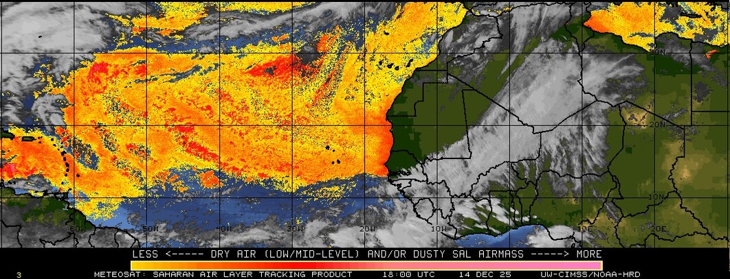
Real time status of Saharan Air Layer
Image
0 likes   
Visit the Caribbean-Central America Weather Thread where you can find at first post web cams,radars
and observations from Caribbean basin members Click Here

Migle
Tropical Storm
Tropical Storm
Posts: 203
Age: 43
Joined: Fri Aug 27, 2010 5:30 pm
Location: New Orleans

Re: Gulf of Guinea factor on Cape Verde activity

#2 Postby Migle » Fri Jun 10, 2011 3:00 pm

Wow, the SAL is no where near as bad as it was last year. Seemed liked the entire Atlantic was covered in dark red this time last year.
0 likes   

User avatar
KWT
Category 5
Category 5
Posts: 31415
Joined: Tue Aug 17, 2004 11:02 am
Location: UK!!!

#3 Postby KWT » Fri Jun 10, 2011 3:26 pm

IMO thats because the ITCZ was much more advanced this time last year...I suspect we'll see the SAL really pump up early July, probably right on the average that I've noticed...SAL tends to normally start to show itself between the 15-30th of June.

That being said it is pretty moist at the moment out there even for June...lets see what happens when the ITCZ actually lifts up to a greater extent this month.

If there is still no hint of severe SAL outbreaks this time next month, then that will be more unusual...
0 likes   
Personal Forecast Disclaimer:
The posts in this forum are NOT official forecast and should not be used as such. They are just the opinion of the poster and may or may not be backed by sound meteorological data. They are NOT endorsed by any professional institution or storm2k.org. For official information, please refer to the NHC and NWS products

User avatar
NDG
S2K Supporter
S2K Supporter
Posts: 15446
Joined: Sun Jul 09, 2006 10:14 pm
Location: Orlando, FL

#4 Postby NDG » Fri Jun 10, 2011 5:07 pm

Last time we saw a cool down in the Gulf of Guinea about the same time of the year was in 2005.
0 likes   

User avatar
cycloneye
Admin
Admin
Posts: 145370
Age: 68
Joined: Thu Oct 10, 2002 10:54 am
Location: San Juan, Puerto Rico

Re:

#5 Postby cycloneye » Fri Jun 10, 2011 5:28 pm

NDG wrote:Last time we saw a cool down in the Gulf of Guinea about the same time of the year was in 2005.


That is correct.2005 saw a big cooldown in the Gulf of Guinea, although it was more cold than 2011 so far.

Image
0 likes   
Visit the Caribbean-Central America Weather Thread where you can find at first post web cams,radars
and observations from Caribbean basin members Click Here

User avatar
Ptarmigan
Category 5
Category 5
Posts: 5313
Joined: Wed Aug 16, 2006 9:06 pm

Re: Gulf of Guinea factor on Cape Verde activity

#6 Postby Ptarmigan » Sat Jun 11, 2011 11:14 pm

Interesting. It would be interesting to see if there is a correlation with Gulf of Guinea and hurricane activity.

2010
Image
Gulf of Guinea was warmer than normal.

2008
Image
Gulf of Guinea was cooler in spots, while others were warmer.

2004
Image
Gulf of Guinea was cooler than normal. Looks like 2005.

1999
Image
Gulf of Guinea was warmer than normal.

1998
Image
Gulf of Guinea was warmer than normal.
0 likes   

User avatar
cycloneye
Admin
Admin
Posts: 145370
Age: 68
Joined: Thu Oct 10, 2002 10:54 am
Location: San Juan, Puerto Rico

Re: Gulf of Guinea factor on Cape Verde activity

#7 Postby cycloneye » Sun Jun 12, 2011 9:10 am

Ptarmigan, if the stats are right, when the Gulf of Guinea cools, more CV activity occurs,and when warmer Gulf the contrary,but is not a conclusive evidence.

http://www.aoml.noaa.gov/hrd/Landsea/6-11mo/Tables.html
0 likes   
Visit the Caribbean-Central America Weather Thread where you can find at first post web cams,radars
and observations from Caribbean basin members Click Here

KBBOCA
S2K Supporter
S2K Supporter
Posts: 1559
Joined: Fri Sep 05, 2003 5:27 am
Location: Formerly Boca Raton, often West Africa. Currently Charlotte NC

#8 Postby KBBOCA » Sun Jun 12, 2011 2:58 pm

I am currently working in Nouakchott, Mauritania, and I can confirm we've had a remarkably cool and quite dust-free spring. Everyone I know is remarking on how little dust there's been this year.

Thanks cyclone eye for an interesting and informative post.
0 likes   

User avatar
cycloneye
Admin
Admin
Posts: 145370
Age: 68
Joined: Thu Oct 10, 2002 10:54 am
Location: San Juan, Puerto Rico

Re: Gulf of Guinea factor on Cape Verde activity

#9 Postby cycloneye » Sun Jun 12, 2011 3:09 pm

30 day forecast for Gulf of Guinea anomalies. Certainly,not a good combination to have the Gulf of Guinea cooling, while the Eastern Atlantic gets warmer.

Image
0 likes   
Visit the Caribbean-Central America Weather Thread where you can find at first post web cams,radars
and observations from Caribbean basin members Click Here

User avatar
Ptarmigan
Category 5
Category 5
Posts: 5313
Joined: Wed Aug 16, 2006 9:06 pm

Re: Gulf of Guinea factor on Cape Verde activity

#10 Postby Ptarmigan » Sun Jun 12, 2011 3:34 pm

cycloneye wrote:Ptarmigan, if the stats are right, when the Gulf of Guinea cools, more CV activity occurs,and when warmer Gulf the contrary,but is not a conclusive evidence.

http://www.aoml.noaa.gov/hrd/Landsea/6-11mo/Tables.html


I saw the link you mentioned and it only goes up to 1950. There is also Sahel Index.
http://jisao.washington.edu/data_sets/sahel/
0 likes   

User avatar
gatorcane
S2K Supporter
S2K Supporter
Posts: 23691
Age: 47
Joined: Sun Mar 13, 2005 3:54 pm
Location: Boca Raton, FL

#11 Postby gatorcane » Sun Jun 12, 2011 3:38 pm

Very nice graphic Cycloneye as we can see how the Gulf is cooling while the MDR remains warm.

I am very curious how this cooling effect plays out come August and September in the MDR.

Also, very good topic as I did not know the impact of the Gulf of Guinea until reading this thread.
0 likes   

User avatar
cycloneye
Admin
Admin
Posts: 145370
Age: 68
Joined: Thu Oct 10, 2002 10:54 am
Location: San Juan, Puerto Rico

Re:

#12 Postby cycloneye » Thu Jun 16, 2011 3:31 pm

gatorcane wrote:Very nice graphic Cycloneye as we can see how the Gulf is cooling while the MDR remains warm.

I am very curious how this cooling effect plays out come August and September in the MDR.

Also, very good topic as I did not know the impact of the Gulf of Guinea until reading this thread.


Important implications for the CV season in terms of more activity than normal as I said at the first post if this cooling trend of the GOG continues. Yes,many peeps have not heard about this factor before.
0 likes   
Visit the Caribbean-Central America Weather Thread where you can find at first post web cams,radars
and observations from Caribbean basin members Click Here

User avatar
cycloneye
Admin
Admin
Posts: 145370
Age: 68
Joined: Thu Oct 10, 2002 10:54 am
Location: San Juan, Puerto Rico

Re: Gulf of Guinea factor on Cape Verde activity

#13 Postby cycloneye » Thu Jun 23, 2011 6:52 am

Is even turning more colder than when I made this thread on June 10th, as purple colors are showing up apart from the blue. Already,the first effect of those cold waters has been to cause the monsoon trough to lift northward inside Africa. At the first post,you can see how this factor can cause plenty of CV systems to form this season.

Image

Uploaded by imageshack.us
0 likes   
Visit the Caribbean-Central America Weather Thread where you can find at first post web cams,radars
and observations from Caribbean basin members Click Here

User avatar
Blown Away
S2K Supporter
S2K Supporter
Posts: 10147
Joined: Wed May 26, 2004 6:17 am

Re: Gulf of Guinea factor on Cape Verde activity

#14 Postby Blown Away » Thu Jun 23, 2011 7:59 am

:uarrow:
I wonder if this effect will allow the waves coming off Africa to develope farther east and recurve before affecting land?? Sure does look like we will have an active CV season, if the BH is stronger this year it may spell trouble farther west!
0 likes   
Hurricane Eye Experience: David 79, Irene 99, Frances 04, Jeanne 04, Wilma 05... EYE COMING MY WAY IN 2024…
Hurricane Brush Experience: Andrew 92, Erin 95, Floyd 99, Matthew 16, Irma 17, Ian 22, Nicole 22…

User avatar
cycloneye
Admin
Admin
Posts: 145370
Age: 68
Joined: Thu Oct 10, 2002 10:54 am
Location: San Juan, Puerto Rico

Re: Gulf of Guinea factor on Cape Verde activity

#15 Postby cycloneye » Thu Jun 23, 2011 9:00 am

Blown Away wrote::uarrow:
I wonder if this effect will allow the waves coming off Africa to develope farther east and recurve before affecting land?? Sure does look like we will have an active CV season, if the BH is stronger this year it may spell trouble farther west!


The key for any landfalls from CV systems this season is simple, weak high equals fish (Unless some develop west of 50W),stronger high equals landfalls downstream.
0 likes   
Visit the Caribbean-Central America Weather Thread where you can find at first post web cams,radars
and observations from Caribbean basin members Click Here

User avatar
cycloneye
Admin
Admin
Posts: 145370
Age: 68
Joined: Thu Oct 10, 2002 10:54 am
Location: San Juan, Puerto Rico

Re: Gulf of Guinea factor on Cape Verde activity

#16 Postby cycloneye » Sat Jan 05, 2013 8:22 am

I had to bump this thread as it's going to be important to watch from a few months before the 2013 Atlantic Hurricane season kicks in,how the Gulf of Guinea is doing to see depending on how warm or cold it is, the ITCZ inside Africa moves more north or not.

As of January 3rd the GOG is warm.

Image

Image
0 likes   
Visit the Caribbean-Central America Weather Thread where you can find at first post web cams,radars
and observations from Caribbean basin members Click Here

User avatar
cycloneye
Admin
Admin
Posts: 145370
Age: 68
Joined: Thu Oct 10, 2002 10:54 am
Location: San Juan, Puerto Rico

Re: Gulf of Guinea factor on Cape Verde activity

#17 Postby cycloneye » Thu Jan 24, 2013 6:46 am

Here is a good map of the Gulf of Guinea.

Image
0 likes   
Visit the Caribbean-Central America Weather Thread where you can find at first post web cams,radars
and observations from Caribbean basin members Click Here

User avatar
Ntxw
Storm2k Moderator
Storm2k Moderator
Posts: 22786
Joined: Wed Oct 21, 2009 6:34 pm
Location: DFW, Texas

#18 Postby Ntxw » Thu Jan 24, 2013 2:43 pm

An outside thought that maybe perhaps someone might know more. The ITCZ is effected by convection in Africa which in turn is fueled by the monsoon season over in the Indian Ocean. Perhaps researching into that region may give us better insight on which systems develop as well as drought/rain conditions in Africa? The IO monsoon usually begins in June and maximizes in September, is there a good correlation between when the monsoon kicks off to how late a season starts?
0 likes   
The above post and any post by Ntxw is NOT an official forecast and should not be used as such. It is just the opinion of the poster and may or may not be backed by sound meteorological data. It is NOT endorsed by any professional institution including Storm2k. For official information, please refer to NWS products.

  Help support Storm2K!
Help Support Storm2K


Return to “Talkin' Tropics”

Who is online

Users browsing this forum: BobHarlem, cajungal, Cpv17, hurricane2025, MarioProtVI, Stratton23, Teban54 and 36 guests