Global model runs discussion
Moderator: S2k Moderators


-
Rgv20

- S2K Supporter

- Posts: 2466
- Age: 39
- Joined: Wed Jan 05, 2011 5:42 pm
- Location: Edinburg/McAllen Tx
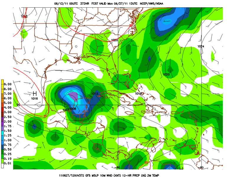
GFS Fantasy Land has it in the Bay Of Campeche.
0 likes
The following post is NOT an official forecast and should not be used as such. It is just the opinion of the poster and may or may not be backed by sound meteorological data. It is NOT endorsed by any professional institution including storm2k.org For Official Information please refer to the NHC and NWS products.
-
Ivanhater

- Storm2k Moderator

- Posts: 11221
- Age: 39
- Joined: Fri Jul 01, 2005 8:25 am
- Location: Pensacola
Re: Global Model Runs Discussion
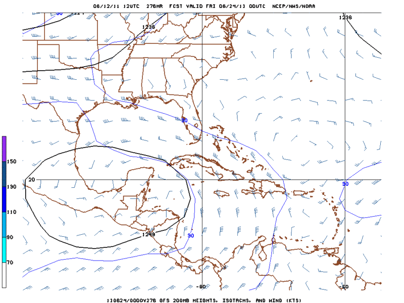
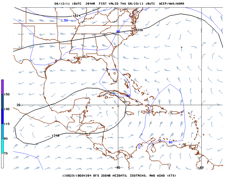
Both the Euro and Canadian have the same same scenario
[img]
Uploaded with ImageShack.us[/img]
[img]
Uploaded with ImageShack.us[/img]
[img]

Uploaded with ImageShack.us[/img]
[img]

Uploaded with ImageShack.us[/img]
0 likes
Michael

Re: Global Model Runs Discussion
Looks reasonable. Well see how future guidance follows suit or Not.
0 likes
-
Rgv20
- S2K Supporter
- Posts: 2466
- Age: 39
- Joined: Wed Jan 05, 2011 5:42 pm
- Location: Edinburg/McAllen Tx
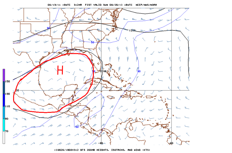
Notice the nice 200mb Ridge that the GFS is forecasting to set up in the Bay of Campeche and the Western Caribbean. That would imply a really favorable environment as we head into late June.
0 likes
The following post is NOT an official forecast and should not be used as such. It is just the opinion of the poster and may or may not be backed by sound meteorological data. It is NOT endorsed by any professional institution including storm2k.org For Official Information please refer to the NHC and NWS products.


Re: Global Model Runs Discussion
For those that like to look into the ultra long range. The CFS has been adverstising for over a week now that the real action is going to begin first and second week of July. The site below is about 2 days behind in the output but you can scroll though the previous week. I think the CFS did a decent job last year of picking up the pattern of mid atlantic recurvature. This year it seams to be bringing the development a little further west.
http://www.weatheronline.co.uk/cgi-bin/expertcharts?LANG=en&CONT=mamk&MODELL=cfs&MODELLTYP=1&VAR=pslv&WMO=&ZOOM=0&PERIOD=&PANEL=0&ARCHIV=0&BASE=201106100000%26HH%3D336
BTW: it is good to be back on storm2k, I hope everyone has a safe year.
http://www.weatheronline.co.uk/cgi-bin/expertcharts?LANG=en&CONT=mamk&MODELL=cfs&MODELLTYP=1&VAR=pslv&WMO=&ZOOM=0&PERIOD=&PANEL=0&ARCHIV=0&BASE=201106100000%26HH%3D336
BTW: it is good to be back on storm2k, I hope everyone has a safe year.
0 likes
-
Rgv20
- S2K Supporter
- Posts: 2466
- Age: 39
- Joined: Wed Jan 05, 2011 5:42 pm
- Location: Edinburg/McAllen Tx
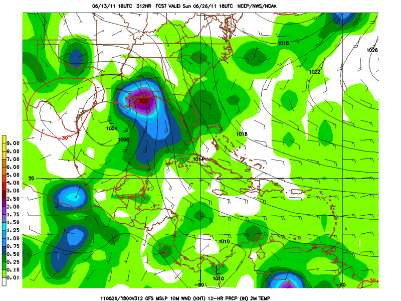
18zGFS continues to show favorable conditions for a tropical disturbance to start taking shape in the Western Caribbean as early as next thursday.
0 likes
The following post is NOT an official forecast and should not be used as such. It is just the opinion of the poster and may or may not be backed by sound meteorological data. It is NOT endorsed by any professional institution including storm2k.org For Official Information please refer to the NHC and NWS products.
-
OuterBanker
- S2K Supporter
- Posts: 1761
- Joined: Wed Feb 26, 2003 10:53 am
- Location: Nags Head, NC
- Contact:
-
srainhoutx

- S2K Supporter
- Posts: 6919
- Age: 68
- Joined: Sun Jan 14, 2007 11:34 am
- Location: Haywood County, NC
- Contact:
Re: Global Model Runs Discussion
wxman57 wrote:srainhoutx wrote:The GFS is less than stellar predicting MJO occurrences, IMO. Trends have been to disregard that 40 day cycle as it has not verified well of late.
It's not just the GFS, it's every model on the MJO site. They all keep the MJO signal very weak and in the Indian Ocean to West Pac for quite a while.
http://www.cpc.ncep.noaa.gov/products/p ... r_wh.shtml
The GFS has now joined the UKMET suggesting an uptick regarding that mjo pulse (albeit weak) I mentioned last week...
0 likes
Carla/Alicia/Jerry(In The Eye)/Michelle/Charley/Ivan/Dennis/Katrina/Rita/Wilma/Ike/Harvey
Member: National Weather Association
Wx Infinity Forums
http://wxinfinity.com/index.php
Facebook.com/WeatherInfinity
Twitter @WeatherInfinity
Member: National Weather Association
Wx Infinity Forums
http://wxinfinity.com/index.php
Facebook.com/WeatherInfinity
Twitter @WeatherInfinity


-
cycloneye

- Admin

- Posts: 149508
- Age: 69
- Joined: Thu Oct 10, 2002 10:54 am
- Location: San Juan, Puerto Rico
Re: Global Model Runs Discussion
The 6/13/11 run of GFS at 12z continues to indicate favorable conditions in the Western Caribbean and the Bay of Campeche/Southern GOM in the long range as a big upper anticyclone is there.

0 likes
Visit the Caribbean-Central America Weather Thread where you can find at first post web cams,radars
and observations from Caribbean basin members Click Here
and observations from Caribbean basin members Click Here
-
Rgv20
- S2K Supporter
- Posts: 2466
- Age: 39
- Joined: Wed Jan 05, 2011 5:42 pm
- Location: Edinburg/McAllen Tx
18zGFS continues to advertise favorable conditions in the Gulf for the end of June.
0 likes
The following post is NOT an official forecast and should not be used as such. It is just the opinion of the poster and may or may not be backed by sound meteorological data. It is NOT endorsed by any professional institution including storm2k.org For Official Information please refer to the NHC and NWS products.
-
Dean4Storms
- S2K Supporter
- Posts: 6358
- Age: 63
- Joined: Sun Aug 31, 2003 1:01 pm
- Location: Miramar Bch. FL
-
cycloneye
- Admin
- Posts: 149508
- Age: 69
- Joined: Thu Oct 10, 2002 10:54 am
- Location: San Juan, Puerto Rico
Re: Global Model Runs Discussion
GFS has been very consistent about showing this system in the GOM for the past 4 days of runs.And it continues now in less than 300 hours timeframe.When you look for model eficiency, a model that shows consistency is key,even if is on long range.

Uploaded by imageshack.us
Uploaded by imageshack.us
0 likes
Visit the Caribbean-Central America Weather Thread where you can find at first post web cams,radars
and observations from Caribbean basin members Click Here
and observations from Caribbean basin members Click Here
-
Dean4Storms
- S2K Supporter
- Posts: 6358
- Age: 63
- Joined: Sun Aug 31, 2003 1:01 pm
- Location: Miramar Bch. FL
-
flwxwatcher
- Category 4

- Posts: 926
- Joined: Wed May 16, 2007 3:35 pm
- Location: Central Florida
Re:
Dean4Storms wrote:I agree Cycloneye and this has been consistent not only day to day but every run every day. I have to believe the TW now approaching the Southern Islands and the NE S. Amer. coast is the genesis in this solution.
The GFS has been consistent but it also did this in the long range with what became 94L and nothing happened. Getting more interested but not buying it lock stock and barrel just yet.
0 likes
-
Ivanhater
- Storm2k Moderator
- Posts: 11221
- Age: 39
- Joined: Fri Jul 01, 2005 8:25 am
- Location: Pensacola
Re: Global Model Runs Discussion
The Euro model has consistently shown a break in the ridge over the western Gulf which would lead whatever this system is north.

0 likes
Michael
-
Hurricane
Who is online
Users browsing this forum: No registered users and 55 guests