Agreed. Consistency has no bearing if a model is consistently incorrect.flwxwatcher wrote:Dean4Storms wrote:I agree Cycloneye and this has been consistent not only day to day but every run every day. I have to believe the TW now approaching the Southern Islands and the NE S. Amer. coast is the genesis in this solution.
The GFS has been consistent but it also did this in the long range with what became 94L and nothing happened. Getting more interested but not buying it lock stock and barrel just yet.
Global model runs discussion
Moderator: S2k Moderators
-
CourierPR

- Category 5

- Posts: 1336
- Age: 72
- Joined: Tue Aug 31, 2004 7:53 pm
- Location: Pompano Beach, Florida
Re: Re:
0 likes
-
cycloneye

- Admin

- Posts: 149508
- Age: 69
- Joined: Thu Oct 10, 2002 10:54 am
- Location: San Juan, Puerto Rico
Re: Global Model Runs Discussion
Climate Prediction Center Tropical Hazards forecast for the next 2 weeks gives GFS some backing.
Below is an excerpt:
There is also some threat for potential tropical development in the Bay of Campeche during the period. Model guidance indicates a disturbance moving northward toward the Gulf coast potentially providing beneficial rainfall drought parched areas of the souther U.S.. The potential at the current time for this is low, however.
http://www.cpc.ncep.noaa.gov/products/p ... /ghazards/
0 likes
Visit the Caribbean-Central America Weather Thread where you can find at first post web cams,radars
and observations from Caribbean basin members Click Here
and observations from Caribbean basin members Click Here
-
AJC3

- Admin
- Posts: 4156
- Age: 62
- Joined: Tue Aug 31, 2004 7:04 pm
- Location: Ballston Spa, New York
- Contact:
Re: Global Model Runs Discussion
Hopefully this doesn't come across as being elitist. My intent is not to call anyone out. But when it comes to looking out beyond 168 hours, and especially beyond 240 hours, honestly, peeps would be much better served by looking at either ensemble guidance or probabilistic forecasts. I'm not trying to tell anyone not to post day 10+ panels from a single deterministic run, however some of the comments I read about their potential to verify are flawed.
There is virtually no skill to deterministic model runs beyond about day 8. None. Nada. ESPECIALLY in the tropics, where global model performance is generally lower to begin with. For every example of a model or models successfully latching onto something in the day 8+ time frame, we can cite dozens and dozens (if not hundreds) of false alarms.
Those who have been here for a few years or longer already know of what I speak, and to those folks, I'm merely preaching to the choir. However, for those who might not know better, I just want to put this out there: The persistence of a feature for several runs in a row in the 300+ hour time frame is well and truly nothing to get excited about. I realize many people here already know this...but there will be some people who come into this thread not knowing this.
So for those who like looking out into "la-la land" I would suggest this: Sure, go ahead and look at the deterministic global model forecasts, but if you do, first determine if there is an iota of support from ensemble (NCEP, ECM) prediction schemes or of probablistic ones such as Paul Roundy's:
http://www.atmos.albany.edu/facstaff/ro ... ecast.html
...or look at the CPC hazards assessment (what Luis posted). Then make your post and state your case. Any less robust of an analysis is tantamount to throwing a dart.
Carry on.
0 likes
-
Rgv20

- S2K Supporter

- Posts: 2466
- Age: 39
- Joined: Wed Jan 05, 2011 5:42 pm
- Location: Edinburg/McAllen Tx
The GFS has been very consistent on showing unsettled weather in the southern gulf and some favorable environment in the BOC.
Favorable conditions expanding north as we head toward the end of June.
Moisture creeping out of the Southern Gulf.

Favorable conditions expanding north as we head toward the end of June.
Moisture creeping out of the Southern Gulf.
0 likes
The following post is NOT an official forecast and should not be used as such. It is just the opinion of the poster and may or may not be backed by sound meteorological data. It is NOT endorsed by any professional institution including storm2k.org For Official Information please refer to the NHC and NWS products.
-
Dean4Storms
- S2K Supporter
- Posts: 6358
- Age: 63
- Joined: Sun Aug 31, 2003 1:01 pm
- Location: Miramar Bch. FL
Re: Global Model Runs Discussion
AJC3 wrote:Hopefully this doesn't come across as being elitist. My intent is not to call anyone out. But when it comes to looking out beyond 168 hours, and especially beyond 240 hours, honestly, peeps would be much better served by looking at either ensemble guidance or probabilistic forecasts. I'm not trying to tell anyone not to post day 10+ panels from a single deterministic run, however some of the comments I read about their potential to verify are flawed.
There is virtually no skill to deterministic model runs beyond about day 8. None. Nada. ESPECIALLY in the tropics, where global model performance is generally lower to begin with. For every example of a model or models successfully latching onto something in the day 8+ time frame, we can cite dozens and dozens (if not hundreds) of false alarms.
Those who have been here for a few years or longer already know of what I speak, and to those folks, I'm merely preaching to the choir. However, for those who might not know better, I just want to put this out there: The persistence of a feature for several runs in a row in the 300+ hour time frame is well and truly nothing to get excited about. I realize many people here already know this...but there will be some people who come into this thread not knowing this.
So for those who like looking out into "la-la land" I would suggest this: Sure, go ahead and look at the deterministic global model forecasts, but if you do, first determine if there is an iota of support from ensemble (NCEP, ECM) prediction schemes or of probablistic ones such as Paul Roundy's:
http://www.atmos.albany.edu/facstaff/ro ... ecast.html
...or look at the CPC hazards assessment (what Luis posted). Then make your post and state your case. Any less robust of an analysis is tantamount to throwing a dart.
Carry on.
Agree 100%!! When I'm talking about giving it some credence I'm talking after so many runs in a row and then looking toward other models/ensembles for support like you are saying. The GFS did sniff out the disturbance 94L in the western Carib. long range although we all know upper level winds kept it from developing the slim potential was there. All I would say from what we've seen from the GFS now going on 5 days in a row is that it has been persistent with the Gulf Low and it is prudent to keep an eye on future runs as well as other models to see if we get any support to the GFS solution. Right now I'd say chances on the GFS solution panning out would be maybe 5% that far out.
0 likes
-
TreasureIslandFLGal

- S2K Supporter
- Posts: 1584
- Age: 58
- Joined: Sun Aug 15, 2004 6:16 pm
- Location: Cancun, Mexico (northeast Yucatan coast)
What is the supposed catalyst for this development the GFS is trying to spin up? Last year there were many predicted developments that never panned out, even with repeated runs of prediction. Unless I can track a reason for the spin up, I don't give it much thought other than for entertainment value.
Is there a wave that somehow makes it to the area in the timing shown? If so, I can't really find/see it now. I also don't see any remnant left behind of a passing front that would kick this off. Is it supposedly sparked from low pressures simply sitting down there and eventually spinning up? Seems hard to do with also a projected anticyclone building over the top of the area projected too simultaneously. Seems you need the low to develope first in the area then the upper atmosphere to cooperate. Just starting with the good upper conditions without the spark below to take advantage of that doesn't usually pan out for initial development.
So, to all you GFS watchers right now...please explain to me how the low gets spun up to begin with. What is the source?
0 likes
Chrissy & Ligeia

-
flwxwatcher
- Category 4

- Posts: 926
- Joined: Wed May 16, 2007 3:35 pm
- Location: Central Florida
Re: Global Model Runs Discussion
Ajc3.. Great post and I agree 100%. The GFS has been consistent as some people have brought up but the thing is, todays run starts to develope a system right around the 240 hr mark. It's has been doing this right around the 240 mark the last 3 or 4 days, so it keeps pushing the development back. It did this with 94l as well, sooner or later if it keeps doing this it will be right. 
0 likes

Re: Global Model Runs Discussion
AJC3 wrote:Hopefully this doesn't come across as being elitist. My intent is not to call anyone out. But when it comes to looking out beyond 168 hours, and especially beyond 240 hours, honestly, peeps would be much better served by looking at either ensemble guidance or probabilistic forecasts. I'm not trying to tell anyone not to post day 10+ panels from a single deterministic run, however some of the comments I read about their potential to verify are flawed.
There is virtually no skill to deterministic model runs beyond about day 8. None. Nada. ESPECIALLY in the tropics, where global model performance is generally lower to begin with. For every example of a model or models successfully latching onto something in the day 8+ time frame, we can cite dozens and dozens (if not hundreds) of false alarms.
Those who have been here for a few years or longer already know of what I speak, and to those folks, I'm merely preaching to the choir. However, for those who might not know better, I just want to put this out there: The persistence of a feature for several runs in a row in the 300+ hour time frame is well and truly nothing to get excited about. I realize many people here already know this...but there will be some people who come into this thread not knowing this.
So for those who like looking out into "la-la land" I would suggest this: Sure, go ahead and look at the deterministic global model forecasts, but if you do, first determine if there is an iota of support from ensemble (NCEP, ECM) prediction schemes or of probablistic ones such as Paul Roundy's:
http://www.atmos.albany.edu/facstaff/ro ... ecast.html
...or look at the CPC hazards assessment (what Luis posted). Then make your post and state your case. Any less robust of an analysis is tantamount to throwing a dart.
Carry on.
Well said. I don't put much stock in anything beyond 7 days. Anything can change even in one day.
0 likes
Re: Global Model Runs Discussion
flwxwatcher wrote:Ajc3.. Great post and I agree 100%. The GFS has been consistent as some people have brought up but the thing is, todays run starts to develope a system right around the 240 hr mark. It's has been doing this right around the 240 mark the last 3 or 4 days, so it keeps pushing the development back. It did this with 94l as well, sooner or later if it keeps doing this it will be right.
I notice the GFS is bullish at the 13 to 16 day mark. Than it backs off again around the 10 to 13 day mark and gets bullish again, especially around the 8 day mark.
0 likes
-
Dean4Storms
- S2K Supporter
- Posts: 6358
- Age: 63
- Joined: Sun Aug 31, 2003 1:01 pm
- Location: Miramar Bch. FL
-
MGC

- S2K Supporter
- Posts: 5940
- Joined: Sun Mar 23, 2003 9:05 pm
- Location: Pass Christian MS, or what is left.
Re: Global Model Runs Discussion
The only outside chance I see at development is that weak wave currently over the E Carb Sea....might want to keep any eye on it...but, I think the disturbance in EPAC is going to become a TC and that should hold back the W Carb Sea and GOM a bit......MGC
0 likes

-
flwxwatcher
- Category 4
- Posts: 926
- Joined: Wed May 16, 2007 3:35 pm
- Location: Central Florida
Re:
Dean4Storms wrote:I know we can sure use the rain across the Gulf Coast into southern GA and North Florida. Let's hope that we get something rain wise out of it and nothing too deep if it does come to fruition.
I agree with you on that, down here in Florida we need rain bad.. As for the GFS, todays 12Z run did start forming a system earlier in this run compared to the OZ run. Seeing is believing though.
0 likes
-
Ivanhater

- Storm2k Moderator

- Posts: 11221
- Age: 39
- Joined: Fri Jul 01, 2005 8:25 am
- Location: Pensacola
Re: Global Model Runs Discussion
The GFS looks to be the real deal. Whether or not it will be a named system is anyone's guess. Canadian and NAEFS ensemble mean is in agreement with a low pressure system developing in the Western Gulf. In any case there looks to be a decent chance to get some much needed rain along the Gulf coast...


0 likes
Michael
-
Rgv20
- S2K Supporter
- Posts: 2466
- Age: 39
- Joined: Wed Jan 05, 2011 5:42 pm
- Location: Edinburg/McAllen Tx
12zCanadian Ensembles showing unsettled weather in the Gulf from 6-10 days out and then 11-15 days
0 likes
The following post is NOT an official forecast and should not be used as such. It is just the opinion of the poster and may or may not be backed by sound meteorological data. It is NOT endorsed by any professional institution including storm2k.org For Official Information please refer to the NHC and NWS products.
-
Dean4Storms
- S2K Supporter
- Posts: 6358
- Age: 63
- Joined: Sun Aug 31, 2003 1:01 pm
- Location: Miramar Bch. FL
-
cycloneye
- Admin
- Posts: 149508
- Age: 69
- Joined: Thu Oct 10, 2002 10:54 am
- Location: San Juan, Puerto Rico
Re: Global Model Runs Discussion

UKMET MJO forecast:

0 likes
Visit the Caribbean-Central America Weather Thread where you can find at first post web cams,radars
and observations from Caribbean basin members Click Here
and observations from Caribbean basin members Click Here
-
Annie Oakley

- Category 5
- Posts: 1103
- Joined: Tue Jul 31, 2007 12:54 pm
- Location: Texas
-
Ivanhater
- Storm2k Moderator
- Posts: 11221
- Age: 39
- Joined: Fri Jul 01, 2005 8:25 am
- Location: Pensacola
Re: Global Model Runs Discussion
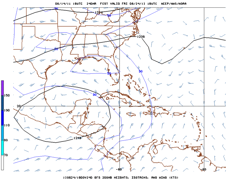
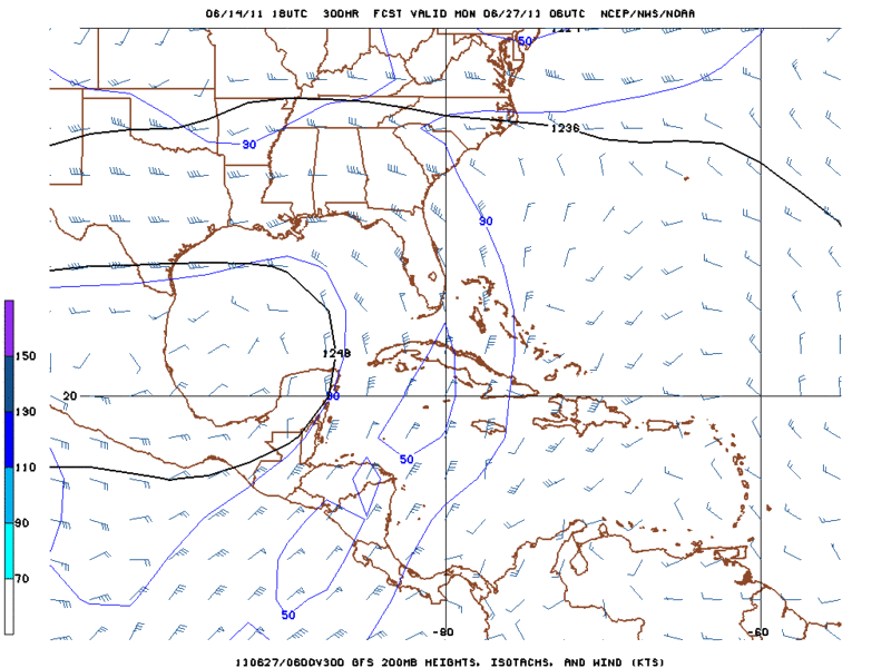
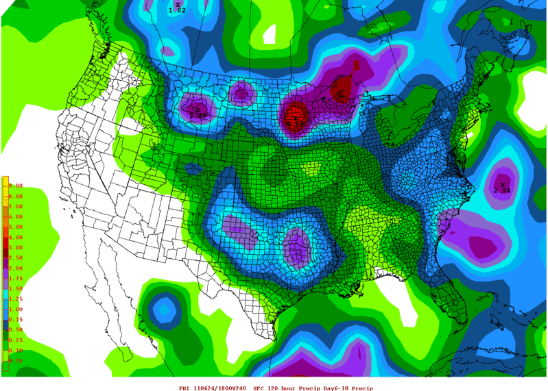
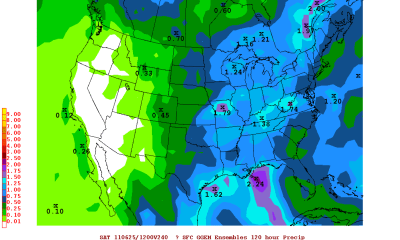
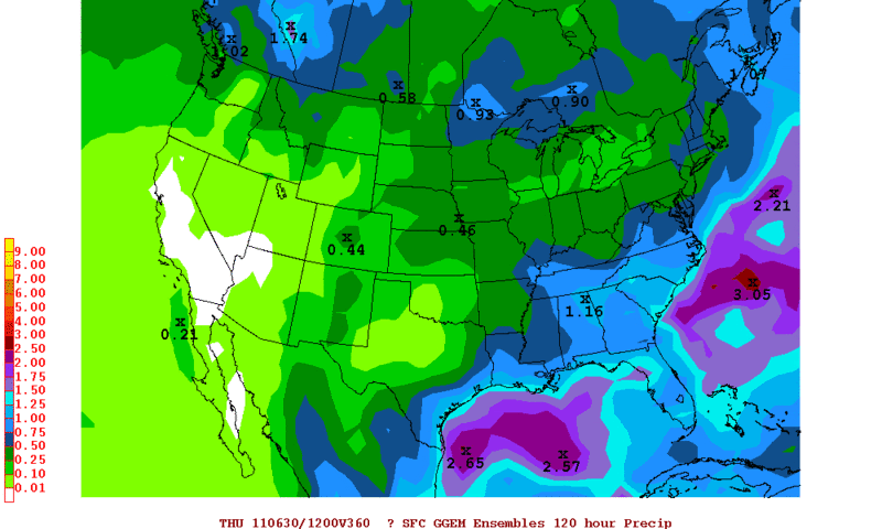
GFS continues to show a 1004mb low pressure developing in the BOC heading north. Deep tropical moisture spreading north along the Texas coast then heads NE along the Gulf coast.....yes please!
[img]
Uploaded with ImageShack.us[/img]
[img]
Uploaded with ImageShack.us[/img]
[img]
Uploaded with ImageShack.us[/img]
[img]

Uploaded with ImageShack.us[/img]
[img]

Uploaded with ImageShack.us[/img]
[img]

Uploaded with ImageShack.us[/img]
0 likes
Michael
Who is online
Users browsing this forum: No registered users and 34 guests