C/S TX Weather: Seasonal with some rains

U.S. & Caribbean Weather Discussions and Severe Weather Events

Moderator: S2k Moderators

Forum rules

The posts in this forum are NOT official forecast and should not be used as such. They are just the opinion of the poster and may or may not be backed by sound meteorological data. They are NOT endorsed by any professional institution or STORM2K.

Help Support Storm2K
Message
Author
User avatar
Rgv20
S2K Supporter
S2K Supporter
Posts: 2466
Age: 38
Joined: Wed Jan 05, 2011 5:42 pm
Location: Edinburg/McAllen Tx

#581 Postby Rgv20 » Fri Jun 17, 2011 8:33 am

Its going to be a HOT Friday :sun:

Heat Advisory

URGENT - WEATHER MESSAGE
NATIONAL WEATHER SERVICE BROWNSVILLE TX
452 AM CDT FRI JUN 17 2011

...HOT AND WINDY CONDITIONS EXPECTED ACROSS DEEP SOUTH TEXAS...

.A SURFACE LOW PRESSURE AREA LOCATED OVER THE SOUTH CENTRAL PLAINS
STATES WILL COMBINE WITH A BROAD SURFACE HIGH PRESSURE SYSTEM OVER
THE SOUTHEASTERN UNITED STATES WILL GENERATE HOT AND WINDY
CONDITIONS ACROSS DEEP SOUTH TEXAS LATER TODAY.

TXZ248>257-171800-
/O.NEW.KBRO.WI.Y.0025.110617T1500Z-110618T0000Z/
/O.NEW.KBRO.HT.Y.0002.110617T1800Z-110618T0000Z/
ZAPATA-JIM HOGG-BROOKS-KENEDY-STARR-HIDALGO-INLAND WILLACY-
INLAND CAMERON-COASTAL WILLACY-COASTAL CAMERON-
INCLUDING THE CITIES OF...ZAPATA...HEBBRONVILLE...FALFURRIAS...
SARITA...RIO GRANDE CITY...ROMA...MCALLEN...EDINBURG...PHARR...
MISSION...WESLACO...RAYMONDVILLE...BROWNSVILLE...HARLINGEN...
PORT MANSFIELD...PORT ISABEL...SOUTH PADRE ISLAND...
LAGUNA HEIGHTS...LAGUNA VISTA
452 AM CDT FRI JUN 17 2011

...WIND ADVISORY IN EFFECT FROM 10 AM THIS MORNING TO 7 PM CDT
THIS EVENING...
...HEAT ADVISORY IN EFFECT FROM 1 PM THIS AFTERNOON TO 7 PM CDT
THIS EVENING...

THE NATIONAL WEATHER SERVICE IN BROWNSVILLE HAS ISSUED A WIND
ADVISORY...WHICH IS IN EFFECT FROM 10 AM THIS MORNING TO 7 PM CDT
THIS EVENING. A HEAT ADVISORY HAS ALSO BEEN ISSUED. THIS HEAT
ADVISORY IS IN EFFECT FROM 1 PM THIS AFTERNOON TO 7 PM CDT THIS
EVENING.

THE COMBINATION OF A SURFACE LOW PRESSURE AREA LOCATED OVER THE
SOUTH CENTRAL PLAINS STATES AND A SURFACE HIGH PRESSURE AREA OVER
THE SOUTHEASTERN STATES WILL RESULT IN SOUTH TO SOUTHEAST WINDS
INCREASING INTO THE 25 TO 35 MPH RANGE LATER THIS MORNING. THESE
STRONG WINDS WILL PERSIST INTO THE LATE AFTERNOON HOURS.

IN ADDITION TO THE WINDY CONDITIONS...THE COMBINATION OF MID LEVEL
RIDGING...HIGH SURFACE RELATIVE HUMIDITY VALUES AND ABUNDANT
SUNSHINE WILL PUSH HEAT INDEX VALUES INTO THE 110 TO 115 DEGREE
RANGE FOR A COUPLE OF HOURS THIS AFTERNOON. THE HEAT INDEX VALUES
WILL START TO FALL LATER THIS EVENING AS SUNSET APPROACHES.

PRECAUTIONARY/PREPAREDNESS ACTIONS...

A WIND ADVISORY IS ISSUED WHEN SUSTAINED WINDS ARE FORECAST TO BE
30 TO 39 MPH AND OR FREQUENT GUSTS WILL RANGE BETWEEN 40 AND
57 MPH.

A HEAT ADVISORY IS ISSUED WHEN THE HEAT INDEX...A MEASURE OF HOW
IT FEELS WHEN TEMPERATURE AND HUMIDITY ARE COMBINED...EQUALS OR
EXCEEDS 111 FOR 2 HOURS OR MORE DURING THE DAY...AND OBSERVED
NIGHTTIME TEMPERATURES REMAIN 75 DEGREES OR ABOVE...FOR TWO
CONSECUTIVE DAYS OR MORE.

&&

$$
0 likes   
The following post is NOT an official forecast and should not be used as such. It is just the opinion of the poster and may or may not be backed by sound meteorological data. It is NOT endorsed by any professional institution including storm2k.org For Official Information please refer to the NHC and NWS products.

User avatar
Portastorm
Storm2k Moderator
Storm2k Moderator
Posts: 9914
Age: 63
Joined: Fri Jul 11, 2003 9:16 am
Location: Round Rock, TX
Contact:

Re: C/SC TX Weather: Frying Pan Summer

#582 Postby Portastorm » Fri Jun 17, 2011 11:33 am

We (Austin) look to be on par with yesterday. The low overnight was only 80 degrees which is sick, but the humidity level is higher than yesterday which ... of course ... means the heat index will be higher.

104 here yesterday.

The heat goes on ...
0 likes   
Any forecasts under my name are to be taken with a grain of salt. Get your best forecasts from the National Weather Service and National Hurricane Center.

Shoshana
Category 5
Category 5
Posts: 1414
Joined: Thu Sep 09, 2004 7:50 pm
Location: NE Austin

#583 Postby Shoshana » Fri Jun 17, 2011 3:30 pm

Day 13 of 100+

I almost feel like saying "Tuesday will be day 17" and then start tracking again on Wednesday!

The fire in Leander is 90% contained, now there is one in Hays Country.
0 likes   

User avatar
Houstonia
S2K Supporter
S2K Supporter
Posts: 829
Age: 60
Joined: Fri Oct 11, 2002 9:45 am
Location: Sharpstown, Houston, Harris County, Southeast Texas.

Re: C/SC TX Weather: Frying Pan Summer

#584 Postby Houstonia » Fri Jun 17, 2011 3:57 pm

http://abclocal.go.com/ktrk/story?section=news%2Flocal&id=8197157&cmp=fb-ktrk-article-8197157

Homes evacuated due to fire near Spring
Updated at 03:45 PM today

HOUSTON (KTRK) -- Officials are evacuating about 200 homes due to a wildfire burning in the Spring area.

Authorities are driving through a section of the Breckenridge Forest subdivision, advising families in about 200 homes to evacuate. The process is underway now.

The fire has been burning along FM 1960 near the Hardy Toll Road area of northeast Harris County. The fire appeared to have broken out in an area that's already had many trees cleared out for development.

So far no structures have burned. The first reports of the fire came in about 11am. No injuries have been reported.

(Copyright ©2011 KTRK-TV/DT. All Rights Reserved.)
0 likes   

User avatar
Houstonia
S2K Supporter
S2K Supporter
Posts: 829
Age: 60
Joined: Fri Oct 11, 2002 9:45 am
Location: Sharpstown, Houston, Harris County, Southeast Texas.

Re: C/SC TX Weather: Frying Pan Summer

#585 Postby Houstonia » Fri Jun 17, 2011 4:05 pm

edited for a better URL/better source:

http://abclocal.go.com/ktrk/story?section=news/local&id=8194899

HOUSTON (KTRK) -- The city of Houston is asking for the public's help to voluntarily conserve water during this period of prolonged drought.

Mayor Annise Parker at an afternoon press conference today said the city is implementing a Stage 1 Water Conservation Plan, a first step when the city's water system may be under stress.

"We have ample supplies of water in reservoirs and our transmission system, but because of shifting clay soil in the city of Houston, we are facing water main breaks which is affecting our water distribution," Mayor Parker said.

She urged residents to cut back on irrigation to prioritize water pressure for homes and businesses. The mayor suggested that property owners with even-numbered street addresses water their lawns on Sunday and Thursday, and property owners with odd-numbered street addresses water on Saturday and Wednesday.

"We do need the public's help. In addition to conservation, we need to know where water line breaks are as soon as possible," said the mayor.

She also said the city is cutting its water by 10% and asking all departments to look at water use, including the Parks Department, but she said they will water appropriately to maintain the tree canopy and prevent tree loss.

The mayor said Stage 2 would require mandatory water conservation.

Other communities around Houston

A number of other communities are facing high water usage, as our extremely hot and dry weather continues its record streak.

Despite the completion of repairs to a water line that broke last week, League City is still enacting stage three of their drought contingency plan, in an effort to maintain pressure for firefighting purposes and to avoid other problems associated with low pressure. Violations of the restrictions are considered misdemeanor crimes. Violators may face fines of $500 plus court fees each day that one or more restrictions are violated.

League City mandatory water restrictions:

* Irrigation of landscaped areas is limited to Tuesdays and Thursdays for water customers with even-numbered addresses, and Mondays and Wednesdays for water customers with odd-numbered addresses. Irrigation of landscaped areas is further limited to the hours between 8 p.m. and 5 a.m. on designated watering days. Irrigation shall be by means of hand-held hoses, hand-held buckets, drip irrigation, or permanently installed automatic sprinkler system only. The use of hose-end sprinklers is prohibited at all times.
* Use of water to wash any motor vehicle, motorbike, boat, trailer, airplane, or other vehicle is prohibited except on designated watering days from 8 p.m. to 5 a.m. Such washing, when allowed, shall be done with a hand-held bucket or a hand-held hose equipped with a positive shutoff nozzle for quick rinses. Vehicle washing may be done at any time on the premises of a commercial car wash or commercial service station. Washing may be exempted from these regulations if the health, safety and welfare of the public is contingent upon frequent vehicle cleansing, such as garbage trucks and vehicles used to transport food and perishables.
* Use of water to fill, refill or add to any indoor or outdoor swimming pools, wading pools and Jacuzzi-type pools is prohibited except on designated watering days from 8 p.m. to 5 a.m.
* Use of water for washing down of any sidewalks, driveways, parking lots, or other hard-surfaced areas is prohibited.
* Using water to wash down buildings or structures for purposes other than immediate fire protection is prohibited.
* Flushing gutters or permitting water to run or accumulate in any gutter or street is prohibited.
* Failing to repair a controllable leak within a reasonable period of five days after having been given notice directing the repair of such leak is prohibited.
* Operation of any ornamental fountain or pond for aesthetic or scenic purposes is prohibited except when necessary to support aquatic life or when such fountains or ponds are equipped with a recirculation system.
* Use of water from hydrants shall be limited to fire fighting, related activities, or other activities necessary to maintain public health, safety and welfare, except that use of water from designated fire hydrants for construction purposes under special permit is discontinued.
* All restaurants are prohibited from serving water to patrons except upon request of the patron.
* The watering of golf course tee boxes is prohibited unless the golf course utilizes a water source other than that provided by the city.
* The City of League City will continue to monitor the water levels and update residents on http://www.leaguecity.com

Sugar Land voluntary water conservation details:

To reduce peak demand and total water consumption, Sugar Land residents are asked to water lawns according to the following schedule:
* Even numbered addresses on even numbered days of the month from 8 p.m. to midnight
* Odd numbered addresses on odd numbered days of the month from 8 p.m. to midnight
* For more information on the city's voluntary irrigation schedule, call the Sugar Land Utilities Department at 281-275-2450

Pearland outdoor watering schedule:

* Residents are asked to limit non-essential water use to the hours of 6 a.m. to 10 a.m. or 8 p.m. to 10 p.m. Monday through Friday.
* Odd-numbered addresses are requested to water on odd dates and even-numbered addresses are requested to water on even dates. For example, 3519 Liberty Drive can water on June 17, 19, 21, etc. since the address ends in an odd number.
* For more information about the voluntary watering schedule or the Water Conservation and Drought Contingency Plan, please call the Public Works Department at 281-652-1900

La Porte voluntary reduction in water usage

* The City of La Porte has issued a formal notice informing citizens that the City is implementing a Stage 1 "Mild Conditions" drought contingency alert and is calling for a voluntary reduction in water usage by residents and business owners.
* The City requests that all residential and commercial users reduce their water consumption where possible and restrict their lawn watering to every other day between the hours of 6  10 a.m. and 8  10 p.m.
* Please visit the City of La Porte website at LaPorteTX.gov for the most up to date information related to the City's Drought Contingency Plan or call 281-470-5020.

The City of Galveston is enacting stage three of its Drought Contingency Plan. Restrictions on water use will continue until further notice, as of June 16. Violating the following water use restrictions could result in fines and penalties.

The City of Galveston has instituted the following water restrictions:

* Irrigation of landscaped areas is limited to Tuesdays and Thursdays for water customers east of 103rd Street, and Wednesdays and Fridays for water customers west of 103rd Street and must be completed before 10AM or after 8:00PM on designated days. Watering by means of a hand-held hose, a faucet filled bucket or watering can of five (5) gallons or less, or drip irrigation system is allowed on designated days. The use of hoseend sprinklers and automatic sprinkler systems is prohibited at all times.
* Private use of water to wash any motor vehicle, motorbike, boat, trailer, airplane or other vehicle is prohibited except on designated watering days before 10AM or after 8PM. Such washing, when allowed, shall be done with a hand-held bucket or a hand-held hose equipped with a positive shutoff nozzle for quick rinses. Vehicle washing may be done at any time on the premises of a commercial car wash or commercial service station. Further, such washing may be exempted from these regulations if, as determined by the Director of Municipal Utilities, the health, safety, and welfare of the public is contingent upon frequent vehicle cleansing, such as garbage trucks, fishing vessels, and vehicles used to transport food and perishables.
* Use of water to fill, refill, or add to any indoor or outdoor swimming pools, wading pools or Jacuzzi-type pools is prohibited except on designated watering days before 10AM or after 8PM.
* The addition of potable water to any ornamental fountain or pond for aesthetic or scenic purposes is prohibited except where necessary to support aquatic life.
* Use of water from hydrants shall be limited to fire fighting, related activities, or other activities necessary to maintain public health, safety, and welfare. The use of water for construction purposes from designated fire hydrants by special permit is prohibited, except with the written permission of the Director of Municipal Utilities.
* Unless permitted by the Director of Municipal Utilities, use of potable water for the irrigation of golf course greens, tees, and fairways is prohibited except on designated watering days before 10AM or after 8PM. However, if the golf course utilizes a water source other than potable water provided by the City of Galveston (e.g. reclaimed, non-potable water), the facility shall not be subject to these regulations. Please note, Moody Gardens, the Moody Gardens Golf Course, and the Galveston Country Club Golf Course use non-potable water to irrigate their landscapes.
* All restaurants are prohibited from serving water to patrons except upon patron request.
* The following uses of potable water are prohibited:
* Washing down of any sidewalks, walkways, driveway, parking lot, tennis courts, or other hard-surfaced areas;
* Washing down buildings or structures for purposes other than immediate fire protection;
* Using water for dust control, except as permitted by the Director of Municipal Utilities;
* Using water for hydrant flushing, flushing gutters, or permitting water to run or accumulate in any street; and
* Failure to repair a controllable leak(s) within a reasonable period after having been given notice directing the repair of such leak(s).
* To report water leaks or violations please call the Public Works Department, Monday  Friday, 8AM  5PM, at 409-797-3630. To report leaks afterhours please call 409-766-2115. To report violations after 5PM on weekdays, as well as on weekends, please call the Galveston Police Department's non-emergency number, 409-765-3702.

Other water conservation tips:

* Set lawn mower blades one notch higher so they cut grass 2 to 3 inches tall, leave grass clippings on lawns,and cover bare ground with mulch to save up to 100 gallons or more per week.
* Check sprinkler heads, valves and drip emitters monthly. Make sure heads are aimed correctly, and immediately repair broken heads.
* Use a broom to clear pavement.
* Use a hose spray nozzle with a shutoff handle to stop water flow.
* Create a water-efficient landscape (called a xeriscape) by using drought-resistant and native plants.
* Repair leaks
* Run faucets only when using them.
* Install water-efficient fixtures.
0 likes   

Shoshana
Category 5
Category 5
Posts: 1414
Joined: Thu Sep 09, 2004 7:50 pm
Location: NE Austin

#586 Postby Shoshana » Fri Jun 17, 2011 4:50 pm

I think Austin automatically goes on Stage 1 every year. Water 2x week during certain hours and different days for even/odd.

Lots of water restrictions in place around South Central Texas right now.

Our patio temp is currently reading 108.5 ... in the shade. It's on the side of the house and I don't know how much heat it's picking up from the house itself (North facing side of the house). I tried finding another place to put it but the patio pillars seem just as warm even in the shade.
0 likes   

User avatar
Portastorm
Storm2k Moderator
Storm2k Moderator
Posts: 9914
Age: 63
Joined: Fri Jul 11, 2003 9:16 am
Location: Round Rock, TX
Contact:

Re: C/SC TX Weather: Frying Pan Summer

#587 Postby Portastorm » Fri Jun 17, 2011 5:30 pm

You're not far off Shoshana ... I think we're sitting 104-105 degrees around much of the metro area as of 5/5:30 p.m. I'm basing this on the official temp at ATT and the LCRA hydromet temp readings.

Thank God we have hope for next week! C'mon Pacific Northwest trough ... break down this Cockroach Ridge of Death and c'mon Bay of Campeche ... spin up some rain for us!

Edit update: Official high at Mabry (ATT) was 106!!
0 likes   
Any forecasts under my name are to be taken with a grain of salt. Get your best forecasts from the National Weather Service and National Hurricane Center.

CajunMama
Retired Staff
Retired Staff
Posts: 10791
Joined: Thu Feb 06, 2003 9:57 pm
Location: 30.22N, 92.05W Lafayette, LA

#588 Postby CajunMama » Fri Jun 17, 2011 6:35 pm

Here in Lafayette we automatically go into a water conservation plan every year beginning May 1. Even and odd addresses swap out every other day and you can't water on Mondays. You can only water from midnight to 2pm. And alot of good that does for people who work.

Hey portastorm and shoshanna...

How long does it take to bake cookies in your car
0 likes   

User avatar
Rgv20
S2K Supporter
S2K Supporter
Posts: 2466
Age: 38
Joined: Wed Jan 05, 2011 5:42 pm
Location: Edinburg/McAllen Tx

#589 Postby Rgv20 » Fri Jun 17, 2011 11:48 pm

Agh almost midnight and its still 85!

Saturday looks like a carbon copy of today with another Heat Advisory for my area.

Heat Advisory

URGENT - WEATHER MESSAGE
NATIONAL WEATHER SERVICE BROWNSVILLE TX
707 PM CDT FRI JUN 17 2011

TXZ248>257-180815-
/O.EXP.KBRO.HT.Y.0002.000000T0000Z-110618T0000Z/
/O.EXP.KBRO.WI.Y.0025.000000T0000Z-110618T0000Z/
/O.NEW.KBRO.HT.Y.0003.110618T0007Z-110619T0000Z/
ZAPATA-JIM HOGG-BROOKS-KENEDY-STARR-HIDALGO-INLAND WILLACY-
INLAND CAMERON-COASTAL WILLACY-COASTAL CAMERON-
INCLUDING THE CITIES OF...ZAPATA...HEBBRONVILLE...FALFURRIAS...
SARITA...RIO GRANDE CITY...ROMA...MCALLEN...EDINBURG...PHARR...
MISSION...WESLACO...RAYMONDVILLE...BROWNSVILLE...HARLINGEN...
PORT MANSFIELD...PORT ISABEL...SOUTH PADRE ISLAND...
LAGUNA HEIGHTS...LAGUNA VISTA
707 PM CDT FRI JUN 17 2011

...HEAT ADVISORY IN EFFECT UNTIL 7 PM CDT SATURDAY...
...HEAT ADVISORY HAS EXPIRED...
...WIND ADVISORY HAS EXPIRED...

THE NATIONAL WEATHER SERVICE IN BROWNSVILLE HAS ISSUED A HEAT
ADVISORY...WHICH IS IN EFFECT UNTIL 7 PM CDT SATURDAY. THE WIND
ADVISORY IS NO LONGER IN EFFECT.

THE COMBINATION OF MID LEVEL RIDGING...HIGH SURFACE RELATIVE
HUMIDITY VALUES AND ABUNDANT SUNSHINE WILL PUSH HEAT INDEX VALUES
INTO THE 110 TO 115 DEGREE RANGE ON SATURDAY. THE HEAT INDEX
VALUES WILL DECREASE THIS EVENING AS SUNSET APPROACHES...HOWEVER
TEMPERATURES WILL REMAIN ABOVE 75 DEGREES DURING THE NIGHTTIME
HOURS.

PRECAUTIONARY/PREPAREDNESS ACTIONS...

A HEAT ADVISORY IS ISSUED WHEN THE HEAT INDEX...A MEASURE OF HOW
IT FEELS WHEN TEMPERATURE AND HUMIDITY ARE COMBINED...EQUALS OR
EXCEEDS 111 FOR 2 HOURS OR MORE DURING THE DAY...AND OBSERVED
NIGHTTIME TEMPERATURES REMAIN 75 DEGREES OR ABOVE...FOR TWO
CONSECUTIVE DAYS OR MORE.

&&

$$
0 likes   
The following post is NOT an official forecast and should not be used as such. It is just the opinion of the poster and may or may not be backed by sound meteorological data. It is NOT endorsed by any professional institution including storm2k.org For Official Information please refer to the NHC and NWS products.

User avatar
Rgv20
S2K Supporter
S2K Supporter
Posts: 2466
Age: 38
Joined: Wed Jan 05, 2011 5:42 pm
Location: Edinburg/McAllen Tx

#590 Postby Rgv20 » Sat Jun 18, 2011 12:13 am

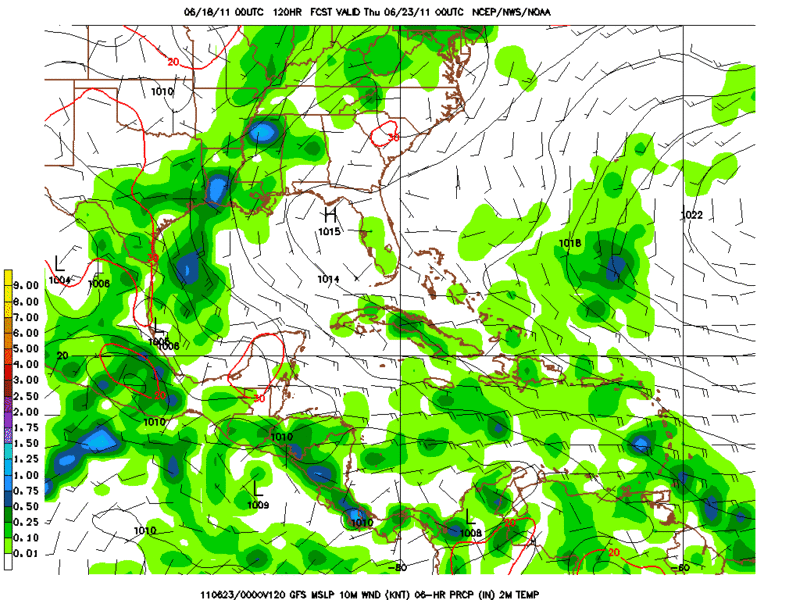
What is that Green stuff over Texas forecast by the 0zGFS!?!? :cheesy: Also the 12zECMWF forecast widespread rain for most of Texas on Wednesday.

Wednesday looks like a Rainy day for South/SC/East Texas.

Image
0 likes   
The following post is NOT an official forecast and should not be used as such. It is just the opinion of the poster and may or may not be backed by sound meteorological data. It is NOT endorsed by any professional institution including storm2k.org For Official Information please refer to the NHC and NWS products.

SaskatchewanScreamer

#591 Postby SaskatchewanScreamer » Sat Jun 18, 2011 2:11 am

Please, oh please, get rid of the cockroach ridge over you so the rain that is constantly being send up here goes your way. My province getting closer to being one big wet disaster and Manitoba is well on its way to becoming Lake Agassiz again. :double:
0 likes   

User avatar
Tireman4
S2K Supporter
S2K Supporter
Posts: 5853
Age: 59
Joined: Fri Jun 30, 2006 1:08 pm
Location: Humble, Texas
Contact:

Re:

#592 Postby Tireman4 » Sat Jun 18, 2011 8:06 am

SaskatchewanScreamer wrote:Please, oh please, get rid of the cockroach ridge over you so the rain that is constantly being send up here goes your way. My province getting closer to being one big wet disaster and Manitoba is well on its way to becoming Lake Agassiz again. :double:


Ms Screamer,

Use your fans and blow is this way. We SOOO need it.
0 likes   

User avatar
Portastorm
Storm2k Moderator
Storm2k Moderator
Posts: 9914
Age: 63
Joined: Fri Jul 11, 2003 9:16 am
Location: Round Rock, TX
Contact:

Re:

#593 Postby Portastorm » Sat Jun 18, 2011 10:54 am

SaskatchewanScreamer wrote:Please, oh please, get rid of the cockroach ridge over you so the rain that is constantly being send up here goes your way. My province getting closer to being one big wet disaster and Manitoba is well on its way to becoming Lake Agassiz again. :double:


Yeah really ... we need to figure out how to funnel your rain down here ... too bad we can't trade?! :lol:
0 likes   
Any forecasts under my name are to be taken with a grain of salt. Get your best forecasts from the National Weather Service and National Hurricane Center.

User avatar
Rgv20
S2K Supporter
S2K Supporter
Posts: 2466
Age: 38
Joined: Wed Jan 05, 2011 5:42 pm
Location: Edinburg/McAllen Tx

#594 Postby Rgv20 » Sat Jun 18, 2011 2:20 pm

Brownsville afternoon discussion.

.LONG TERM /MONDAY THROUGH SATURDAY/...MONDAYS WEATHER LOOKS THE
SAME AS SUNDAY BUT WINDS WILL BE A NOTCH HIGHER. UPPER TROUGH
AXIS JUST MOVING INTO SOUTH ROCKIES. SURFACE LOW TO DEEPEN OVER
THE SOUTHERN AND CENTRAL PLAINS TIGHTENING THE PRESSURE GRADIENT
ACROSS SOUTH TEXAS. CONFIDENCE CONTINUES TO INCREASE ON A
NORTHWARD SURGE OF MOISTURE INTO THE WESTERN GULF OF MEXICO AND
DEEP SOUTH TEXAS. THE INITIAL SURGE COULD COME AS EARLY AS TUESDAY
NIGHT WITH THE NAM INDICATING PWATS OF 2 INCHES WITH A BAND OF QFP
BETWEEN TAMPICO AND THE RIO GRANDE RIVER AT 00Z WEDNESDAY. GFS NOT
TO FAR BEHIND WITH PWATS CLIMBING ABOVE 2 INCHES OVERNIGHT TUESDAY
AND REMAINING ABOVE OR IN THE VICINITY OF 2 INCHES THROUGH NEXT
WEEKEND. THE SSMI/AMSRE DERIVED TOTAL PRECIPITABLE WATER LOOP
SHOWS THESE HIGHER MOISTURE VALUES BEGINNING TO POOL OVER THE BAY
OF CAMPECHE. IN ADDITION A TROPICAL WAVE ACROSS SOUTHWEST
CARIBBEAN IS SHOWN BY THE MODELS TO MOVE WEST NORTHWEST INTO THE
BAY OF CAMPECHE OVER THE NEXT SEVERAL DAYS. AS AN ADDED FEATURE
THE DEPARTING UPPER TROUGH OVER THE CENTRAL PLAINS WILL HAVE A
SURFACE TROUGH EXTENDING SOUTHWEST ACROSS TEXAS AND INTO THE
WESTERN GULF WEDNESDAY THROUGH FRIDAY. MOISTURE TO POOL ALONG
THIS TROUGH AND POSSIBLY COMBINE WITH A THE DAILY SEABREEZE AS
WINDS BACK MORE EAST WITH TIME. IF ALL THESE INGREDIENTS COME
TOGETHER WE SHOULD SEE A STEADY INCREASE IN SHOWERS AND
THUNDERSTORMS. GOING FORECAST HAS BEEN LEANING TOWARDS THIS TREND
THE LAST FEW DAYS AND WITH THE ADDED CONFIDENCE WILL TREND THE
RAIN CHANCES UPWARD. GFS MEX MOS POP FORECAST REMAINING CONSISTENT
WITH BEST CHANCES INDICATED FROM WEDNESDAY THROUGH FRIDAY.
TEMPERATURE AND SKY COVER TREND WILL REMAIN THE SAME AS THE
MOISTURE AND RAIN CHANCES INCREASE TEMPERATURES SHOULD BEGIN TO
LOWER TOWARDS NORMAL.


Confidence is growing on Rain Chances :D

First we gotta get thru this heat at 2pm is 102F with an expected high of 106....good thing my AC is working fine 8-)
0 likes   
The following post is NOT an official forecast and should not be used as such. It is just the opinion of the poster and may or may not be backed by sound meteorological data. It is NOT endorsed by any professional institution including storm2k.org For Official Information please refer to the NHC and NWS products.

Shoshana
Category 5
Category 5
Posts: 1414
Joined: Thu Sep 09, 2004 7:50 pm
Location: NE Austin

#595 Postby Shoshana » Sat Jun 18, 2011 3:30 pm

Day 14

105 currently at Mabry (3:15 pm when I looked) and 102 at Bergstrom with at least another hour or so to cook us.

107 at our house. I'm starting to thing the temp gauge is correct it's just really really dry and hot here.

Yesterday our temp went up to 109 at the house.

We were driving around Cedar Park/Round Rock (nr Brushy Creek) yesterday and saw a lot of dead and dying trees in the pastures and fields. Mesquites, Live Oaks and Cedars plus more I couldn't id. The ragged line of trees behind our property are looking not so good either.

Hope we get a slow steady rain for the days we get it! No high winds or trees will be fallin all over.

We have 2 more fence posts trying to fall over too.

eta:

When do they issue heat advisories?
0 likes   

User avatar
Portastorm
Storm2k Moderator
Storm2k Moderator
Posts: 9914
Age: 63
Joined: Fri Jul 11, 2003 9:16 am
Location: Round Rock, TX
Contact:

Re: C/SC TX Weather: Frying Pan Summer

#596 Postby Portastorm » Sat Jun 18, 2011 3:53 pm

Heat Advisory - Extreme heat index making it feel hot, typically between 105 and 110 °F (41 and 43 °C) for up to 3 hours during the day and at or above 80 °F (27 °C) at night for two consecutive nights. Specific criteria varies over different county warning areas.

Edit update: FWIW, we broke the 2008 record high on this date of 103 degrees as we hit 105.
0 likes   
Any forecasts under my name are to be taken with a grain of salt. Get your best forecasts from the National Weather Service and National Hurricane Center.

User avatar
Ptarmigan
Category 5
Category 5
Posts: 5313
Joined: Wed Aug 16, 2006 9:06 pm

Re: C/SC TX Weather: Frying Pan Summer

#597 Postby Ptarmigan » Sat Jun 18, 2011 5:59 pm

Portastorm wrote:You're not far off Shoshana ... I think we're sitting 104-105 degrees around much of the metro area as of 5/5:30 p.m. I'm basing this on the official temp at ATT and the LCRA hydromet temp readings.

Thank God we have hope for next week! C'mon Pacific Northwest trough ... break down this Cockroach Ridge of Death and c'mon Bay of Campeche ... spin up some rain for us!

Edit update: Official high at Mabry (ATT) was 106!!


I am awaiting the demise of the Cockroach Ridge. Our Pacific Northwest trough is the RAID for the Cockroach Ridge.
0 likes   

User avatar
Ptarmigan
Category 5
Category 5
Posts: 5313
Joined: Wed Aug 16, 2006 9:06 pm

Re:

#598 Postby Ptarmigan » Sat Jun 18, 2011 6:01 pm

SaskatchewanScreamer wrote:Please, oh please, get rid of the cockroach ridge over you so the rain that is constantly being send up here goes your way. My province getting closer to being one big wet disaster and Manitoba is well on its way to becoming Lake Agassiz again. :double:


We need RAID to kill the Cockroach Ridge. :grrr: 8-)
0 likes   

Shoshana
Category 5
Category 5
Posts: 1414
Joined: Thu Sep 09, 2004 7:50 pm
Location: NE Austin

Re: C/SC TX Weather: Frying Pan Summer

#599 Postby Shoshana » Sat Jun 18, 2011 6:41 pm

Portastorm wrote:Heat Advisory - Extreme heat index making it feel hot, typically between 105 and 110 °F (41 and 43 °C) for up to 3 hours during the day and at or above 80 °F (27 °C) at night for two consecutive nights. Specific criteria varies over different county warning areas.

Edit update: FWIW, we broke the 2008 record high on this date of 103 degrees as we hit 105.


Thank you!!

Highs today: Mabry 106 Bergstrom 105

Beffore we left the house earlier our gauge was reading 109. Again.

RAID! RAID! RAID! Where's the Raid! Meanwhile everyone get out your roach stompers! (aka those pointy toe cowboy boots!)
0 likes   

User avatar
Rgv20
S2K Supporter
S2K Supporter
Posts: 2466
Age: 38
Joined: Wed Jan 05, 2011 5:42 pm
Location: Edinburg/McAllen Tx

#600 Postby Rgv20 » Sat Jun 18, 2011 7:39 pm

Looks like our best shot of Rain will be a 48hr period from 7pm Tuesday to 7pm Thursday.

Image
0 likes   
The following post is NOT an official forecast and should not be used as such. It is just the opinion of the poster and may or may not be backed by sound meteorological data. It is NOT endorsed by any professional institution including storm2k.org For Official Information please refer to the NHC and NWS products.


Return to “USA & Caribbean Weather”

Who is online

Users browsing this forum: No registered users and 11 guests