GGEM also shows a 1008mb low drifting northward toward the BOC at 144hrs.......
http://raleighwx.americanwx.com/models/ ... PNA144.gif
Gulf Disturbance Week of June 27th (Is invest 95L)
Moderator: S2k Moderators
Forum rules

The posts in this forum are NOT official forecasts and should not be used as such. They are just the opinion of the poster and may or may not be backed by sound meteorological data. They are NOT endorsed by any professional institution or STORM2K. For official information, please refer to products from the National Hurricane Center and National Weather Service.
-
Dean4Storms
- S2K Supporter

- Posts: 6358
- Age: 62
- Joined: Sun Aug 31, 2003 1:01 pm
- Location: Miramar Bch. FL
-
vbhoutex

- Storm2k Executive

- Posts: 29139
- Age: 74
- Joined: Wed Oct 09, 2002 11:31 pm
- Location: Cypress, TX
- Contact:
Re: Possible Gulf Disturbance (Drought buster?)
wxman57 wrote:Tropical development looks unlikely due to moderate to strong westerly shear in the central to northern Gulf. As for being a "drought buster", almost certainly not. Maybe enough to water the trees/grass if we're lucky in TX/LA coastal areas.
The man states it well. I didn't even look at the shear(dumbie!!)and I still have come to the same conclusion. I am HOPING for everyone calling for development of rains and/or tropical weather to be right, but my skin doesn't look good blue so I am not holding my breath. I sincerely hope my conclusions are incorrect, but I just don't see anything of significance coming our way in SE TX except a possible beginning of a pattern change?
0 likes
Skywarn, C.E.R.T.
Please click below to donate to STORM2K to help with the expenses of keeping the site going:

Please click below to donate to STORM2K to help with the expenses of keeping the site going:
-
southerngale

- Retired Staff

- Posts: 27418
- Joined: Thu Oct 10, 2002 1:27 am
- Location: Southeast Texas (Beaumont area)
Whether it develops or not, NWS LCH has put rain in our forecast... something we haven't seen in a long time.
40% Tuesday, 50% Wednesday and 40% Thursday, with 20-30% chances on some of the other days.
That's just unheard of these days!
40% Tuesday, 50% Wednesday and 40% Thursday, with 20-30% chances on some of the other days.
That's just unheard of these days!
0 likes
Please support Storm2k by making a donation today. It is greatly appreciated! Click here:
 my Cowboys my Rockets my Astros
my Cowboys my Rockets my Astros-
Rgv20

- S2K Supporter
- Posts: 2466
- Age: 39
- Joined: Wed Jan 05, 2011 5:42 pm
- Location: Edinburg/McAllen Tx
Interesting to note that the GFS has the BOC low developing later more in line with the Euro. Going to be interesting to see the trends this up coming week.
Anyway Texas and Louisiana should get some increase moisture by the middle of the week.
Forecast Rainfall by the 18zGFS from Thursday afternoon to Tuesday afternoon.
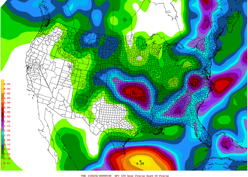
Anyway Texas and Louisiana should get some increase moisture by the middle of the week.
Forecast Rainfall by the 18zGFS from Thursday afternoon to Tuesday afternoon.
0 likes
The following post is NOT an official forecast and should not be used as such. It is just the opinion of the poster and may or may not be backed by sound meteorological data. It is NOT endorsed by any professional institution including storm2k.org For Official Information please refer to the NHC and NWS products.

Re: Possible Gulf Disturbance (Drought buster?)
If we could relocate that bullseye right over Austin, TX.... 
0 likes
-
MississippiHurricane

- ChatStaff

- Posts: 648
- Age: 41
- Joined: Sat Jul 16, 2005 12:20 am
- Location: Hanover, Maryland
- Contact:
Re: Possible Gulf Disturbance (Drought buster?)
Man that would be great  nice rain maybe some winds and cooler temps!
0 likes
-
vbhoutex
- Storm2k Executive
- Posts: 29139
- Age: 74
- Joined: Wed Oct 09, 2002 11:31 pm
- Location: Cypress, TX
- Contact:
Re:
Rgv20 wrote:Interesting to note that the GFS has the BOC low developing later more in line with the Euro. Going to be interesting to see the trends this up coming week.
Anyway Texas and Louisiana should get some increase moisture by the middle of the week.
Forecast Rainfall by the 18zGFS from Thursday afternoon to Tuesday afternoon.
http://i61.photobucket.com/albums/h62/c ... 240hrs.gif
If the GFS continues to trend towards later development like the Euro then I will really begin to watch this closely.(not that I won't still be watching it anyway) I have thought all along it was too early with the possible development.
0 likes
Skywarn, C.E.R.T.
Please click below to donate to STORM2K to help with the expenses of keeping the site going:
Please click below to donate to STORM2K to help with the expenses of keeping the site going:


Re: Possible Gulf Disturbance (Drought buster?)
The scenario depcited by the GFS kind of reminds me of last year's TD 2, although my personal and unofficial opinion is that this system may be a wetter, bigger and a little better organized system than TD 2.
0 likes
-
Rgv20
- S2K Supporter
- Posts: 2466
- Age: 39
- Joined: Wed Jan 05, 2011 5:42 pm
- Location: Edinburg/McAllen Tx
I think one of the factors is how much heat and energy the tropical wave currently near the Windward Islands would provide to all the moisture in the BOC. Would it help kick start a Low in the South Western GOM...only time will tell.
Here is the latest satellite imagery of the Tropical wave.

Latest Analysis of the Caribbean.

And the 72hr forecast from the NHC.

Here is the latest satellite imagery of the Tropical wave.
Latest Analysis of the Caribbean.
And the 72hr forecast from the NHC.
0 likes
The following post is NOT an official forecast and should not be used as such. It is just the opinion of the poster and may or may not be backed by sound meteorological data. It is NOT endorsed by any professional institution including storm2k.org For Official Information please refer to the NHC and NWS products.
-
srainhoutx

- S2K Supporter
- Posts: 6919
- Age: 68
- Joined: Sun Jan 14, 2007 11:34 am
- Location: Haywood County, NC
- Contact:
Re: Possible Gulf Disturbance (Drought buster?)
The 00Z Euro continues to advertise some Bay of Campeche mischief in the longer range. It’s also interesting to note that the 06Z HWRF run for 92E picked up on a EPAC disturbance that appears to cross over into the Western Basin. We will see.
0 likes
Carla/Alicia/Jerry(In The Eye)/Michelle/Charley/Ivan/Dennis/Katrina/Rita/Wilma/Ike/Harvey
Member: National Weather Association
Wx Infinity Forums
http://wxinfinity.com/index.php
Facebook.com/WeatherInfinity
Twitter @WeatherInfinity
Member: National Weather Association
Wx Infinity Forums
http://wxinfinity.com/index.php
Facebook.com/WeatherInfinity
Twitter @WeatherInfinity
-
Weatherfreak000
Re: Possible Gulf Disturbance (Drought buster?)
2011 surprisingly hostile out there so far in the month of June which is now almost over...
Another season gone by and 2005 still reigns. It's IMO important to say that now because we are finally using Katrina's name-set again. That means recent memory from this point on we will look at TS/Hurricane Katia...and Katrina will begin the plummet into obscurity. How long till we can forget that one?
It's gonna be a long time no doubt, but we've finally taken that first step..
0 likes
-
PauleinHouston
- Tropical Storm

- Posts: 102
- Joined: Mon Aug 13, 2007 10:23 am
- Location: League City, TX
- Contact:
Re: Possible Gulf Disturbance (Drought buster?)
Morning to all.
Have been watching the various gulf images/loops this morning and mslp/pw values. To my highly untrained eye, there appears a circulation just West of Yucatan in BOC.
http://www.ssd.noaa.gov/goes/east/gmex/flash-vis.html
With the ridge over SE Texas starting to lift NE, moisture surge is (edit "hopefuly") coming and I hope some very much needed rain. My local station in League City (half way between Houston and Galveston) has recorded a grand total of .10" of rain since March 14th. This gives new meaning to dry!
Last edited by PauleinHouston on Sun Jun 19, 2011 12:06 pm, edited 1 time in total.
0 likes
The posts in this forum are NOT official forecasts and should not be used as such. They are just the opinion of this amateur poster and may or may not be backed by sound meteorological data. They are NOT endorsed by any professional institution or storm2k.org. For official information, please refer to NWS products.
-
lrak

- S2K Supporter
- Posts: 1770
- Age: 59
- Joined: Thu Jun 21, 2007 2:48 pm
- Location: Corpus Christi, TX
Re: Possible Gulf Disturbance (Drought buster?)
I see that too, but satellites sure play funny business on teh eye.
0 likes
AKA karl
Also
Personal Forecast Disclaimer:
My posts on this forum are NOT official forecast and should not be used as such. My posts are my basic observations and are definitely not backed by any "well some" meteorological knowledge. For official information, please refer to the NHC and NWS products.
Also
Personal Forecast Disclaimer:
My posts on this forum are NOT official forecast and should not be used as such. My posts are my basic observations and are definitely not backed by any "well some" meteorological knowledge. For official information, please refer to the NHC and NWS products.

Re: Possible Gulf Disturbance (Drought buster?)
A upper low looks to be cutting off in the BOC
http://www.ssd.noaa.gov/goes/east/gmex/flash-wv.html
That should curtail anything developing anytime soon.
http://www.ssd.noaa.gov/goes/east/gmex/flash-wv.html
That should curtail anything developing anytime soon.
0 likes
The following post is NOT an official forecast and should not be used as such. It is just the opinion of the poster and may or may not be backed by sound meteorological data. It is NOT endorsed by any professional institution including storm2k.org For Official Information please refer to the NHC and NWS products.
-
vbhoutex
- Storm2k Executive
- Posts: 29139
- Age: 74
- Joined: Wed Oct 09, 2002 11:31 pm
- Location: Cypress, TX
- Contact:
Re: Possible Gulf Disturbance (Drought buster?)
PauleinHouston wrote:Morning to all.
Have been watching the various gulf images/loops this morning and mslp/pw values. To my highly untrained eye, there appears a circulation just West of Yucatan in BOC.
http://www.ssd.noaa.gov/goes/east/gmex/flash-vis.html
Select MSLP and Fronts as options as it's now showing a 1012mb area just south of the visible circulation.
With the ridge over SE Texas starting to lift NE, moisture surge is coming and I hope some very much needed rain. My local station in League City (half way between Houston and Galveston) has recorded a grand total of .10" of rain since March 14th. This gives new meaning to dry!
It appears to me that you are seeing the different cloud layers(levels) moving along the air flow as opposed to any turning near the surface or even the mid-levels. I still have to question our local OCMs and their play on the weather this week as there is going to have to be a much stronger and quicker surge of moisture heading N to NW if SE TX and the W GOM are going to get any kind of activity from this.
0 likes
Skywarn, C.E.R.T.
Please click below to donate to STORM2K to help with the expenses of keeping the site going:
Please click below to donate to STORM2K to help with the expenses of keeping the site going:
-
PauleinHouston
- Tropical Storm
- Posts: 102
- Joined: Mon Aug 13, 2007 10:23 am
- Location: League City, TX
- Contact:
Re: Possible Gulf Disturbance (Drought buster?)
Thanks vb...as I said, highly untrained eye, lol.
Yeah, it appears as part of the upper level trough between FL and SW Gulf as mentioned in TWD this morning.
Yeah, it appears as part of the upper level trough between FL and SW Gulf as mentioned in TWD this morning.
0 likes
The posts in this forum are NOT official forecasts and should not be used as such. They are just the opinion of this amateur poster and may or may not be backed by sound meteorological data. They are NOT endorsed by any professional institution or storm2k.org. For official information, please refer to NWS products.
-
Ivanhater

- Storm2k Moderator

- Posts: 11166
- Age: 39
- Joined: Fri Jul 01, 2005 8:25 am
- Location: Pensacola
Re: Possible Gulf Disturbance (Drought buster?)
12z GFS shows the bulk of the disturbance moving toward the north central gulf coast

0 likes
Michael

Re: Possible Gulf Disturbance (Drought buster?)
I dont care what it is rain,T-storm,TD or even fog...  ..we need some moisture here in SE Texas. Already water rationing in effect with no measurable rain fall for what 150+ days....that my friends is insane...my grass has turned to hay...my pool loses about 2 inches of water a day. Hell my pool is running about 92F during the day...it is horrible....
Ivan- have you seen the NAM?
Ivan- have you seen the NAM?
0 likes
Re: Possible Gulf Disturbance (Drought buster?)
PauleinHouston wrote:Thanks vb...as I said, highly untrained eye, lol.
Yeah, it appears as part of the upper level trough between FL and SW Gulf as mentioned in TWD this morning.
not to mention all the dry air in the GOM right now....moisture next week yes but anything more I highly doubt IMO....the shear is screaming in the GOM right now....those tstorm are barfing outflow boundaries so first sign nothing at the surface....
0 likes
Re: Possible Gulf Disturbance (Drought buster?)
The models can tend to be blind to prevailing conditions like the dry conditions preventing formation.
0 likes
Who is online
Users browsing this forum: No registered users and 43 guests