Gulf Disturbance Week of June 27th (Is invest 95L)

This is the general tropical discussion area. Anyone can take their shot at predicting a storms path.

Moderator: S2k Moderators

Forum rules

The posts in this forum are NOT official forecasts and should not be used as such. They are just the opinion of the poster and may or may not be backed by sound meteorological data. They are NOT endorsed by any professional institution or STORM2K. For official information, please refer to products from the National Hurricane Center and National Weather Service.

Help Support Storm2K
Message
Author
jinftl
Category 5
Category 5
Posts: 4312
Joined: Tue Aug 31, 2004 4:47 pm
Location: fort lauderdale, fl

Re: Possible Gulf Disturbance (Drought buster?)

#81 Postby jinftl » Sun Jun 19, 2011 12:45 pm

Climatology isn't really on the side of development - granted, if we are going to see developement this time of year, it will be in the Gulf...but from 1851-2009, development from June 21 through 30 has been anemic:

Image
http://www.nhc.noaa.gov/pastprofile.shtml
0 likes   

Sanibel
Category 5
Category 5
Posts: 10375
Joined: Mon Aug 30, 2004 11:06 pm
Location: Offshore SW Florida

Re: Possible Gulf Disturbance (Drought buster?)

#82 Postby Sanibel » Sun Jun 19, 2011 1:05 pm

There's a very weak hint of a spin headed towards the BOC.
0 likes   

Dean4Storms
S2K Supporter
S2K Supporter
Posts: 6358
Age: 62
Joined: Sun Aug 31, 2003 1:01 pm
Location: Miramar Bch. FL

Re: Possible Gulf Disturbance (Drought buster?)

#83 Postby Dean4Storms » Sun Jun 19, 2011 1:17 pm

PauleinHouston wrote:Morning to all.

Have been watching the various gulf images/loops this morning and mslp/pw values. To my highly untrained eye, there appears a circulation just West of Yucatan in BOC.

http://www.ssd.noaa.gov/goes/east/gmex/flash-vis.html

With the ridge over SE Texas starting to lift NE, moisture surge is (edit "hopefuly") coming and I hope some very much needed rain. My local station in League City (half way between Houston and Galveston) has recorded a grand total of .10" of rain since March 14th. This gives new meaning to dry!


Think you are seeing the ULL over the BOC.
0 likes   

Dean4Storms
S2K Supporter
S2K Supporter
Posts: 6358
Age: 62
Joined: Sun Aug 31, 2003 1:01 pm
Location: Miramar Bch. FL

#84 Postby Dean4Storms » Sun Jun 19, 2011 1:19 pm

The only spin in the area of the BOC is an upper level low.


http://www.ssd.noaa.gov/goes/east/gmex/flash-wv.html
0 likes   

User avatar
southerngale
Retired Staff
Retired Staff
Posts: 27418
Joined: Thu Oct 10, 2002 1:27 am
Location: Southeast Texas (Beaumont area)

#85 Postby southerngale » Sun Jun 19, 2011 1:54 pm

Drought buster? It's gonna take a LOT of rain to bust this drought!

65% of Texas is in the worst category and 89% is in the worst 2 categories. Image


Image

U.S. Drought Monitor
0 likes   
Please support Storm2k by making a donation today. It is greatly appreciated! Click here: Image

Image my Cowboys Image my RocketsImage my Astros

User avatar
Ivanhater
Storm2k Moderator
Storm2k Moderator
Posts: 11162
Age: 38
Joined: Fri Jul 01, 2005 8:25 am
Location: Pensacola

Re: Possible Gulf Disturbance (Drought buster?)

#86 Postby Ivanhater » Sun Jun 19, 2011 2:03 pm

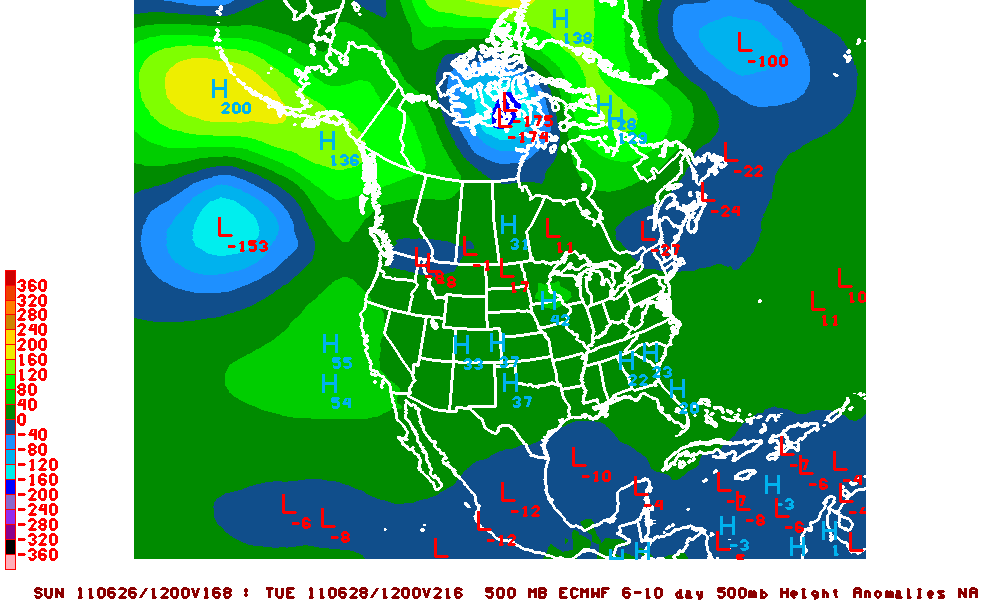
12z Euro has our Gulf disturbance stronger at the end of June..a couple days later than the GFS but the same idea. Movement toward the Upper Texas coast and Louisiana.

Image
0 likes   
Michael

User avatar
Ivanhater
Storm2k Moderator
Storm2k Moderator
Posts: 11162
Age: 38
Joined: Fri Jul 01, 2005 8:25 am
Location: Pensacola

Re: Possible Gulf Disturbance (Drought buster?)

#87 Postby Ivanhater » Sun Jun 19, 2011 2:10 pm

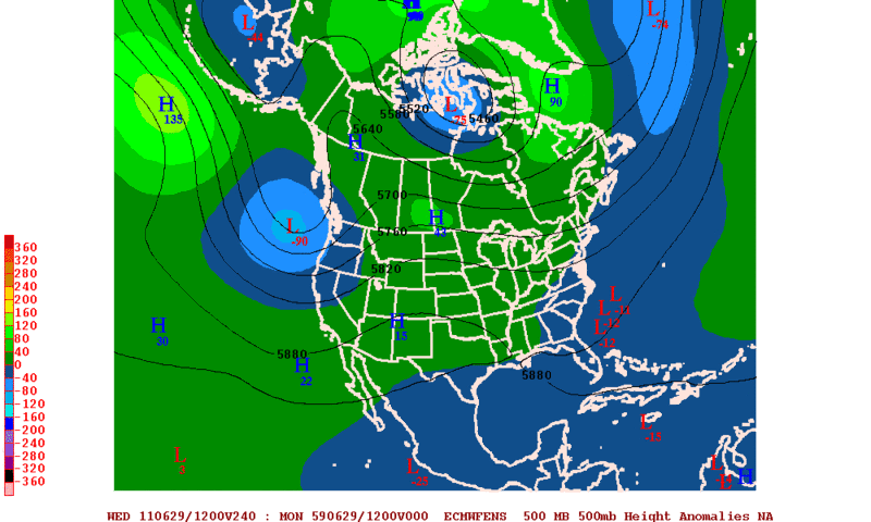
12z Euro strongest run yet

[img]Image

Uploaded with ImageShack.us[/img]

[img]Image

Uploaded with ImageShack.us[/img]
0 likes   
Michael

User avatar
cycloneye
Admin
Admin
Posts: 145455
Age: 68
Joined: Thu Oct 10, 2002 10:54 am
Location: San Juan, Puerto Rico

Re: Possible Gulf Disturbance (Drought buster?)

#88 Postby cycloneye » Sun Jun 19, 2011 2:18 pm

IMO, we dont need NOGAPS,UKMET or CMC, as a consensus between only GFS and ECMWF is sufficient to be credible to think the scenario they are portraying is going to occur.Of course,we need more runs to see if the consensus between the two continues to build or it falls apart.
0 likes   
Visit the Caribbean-Central America Weather Thread where you can find at first post web cams,radars
and observations from Caribbean basin members Click Here

User avatar
srainhoutx
S2K Supporter
S2K Supporter
Posts: 6919
Age: 67
Joined: Sun Jan 14, 2007 11:34 am
Location: Haywood County, NC
Contact:

Re: Possible Gulf Disturbance (Drought buster?)

#89 Postby srainhoutx » Sun Jun 19, 2011 2:47 pm

The 12Z Euro does suggest lower pressures across the Western Gulf in the long range...

Image
0 likes   
Carla/Alicia/Jerry(In The Eye)/Michelle/Charley/Ivan/Dennis/Katrina/Rita/Wilma/Ike/Harvey

Member: National Weather Association
Wx Infinity Forums
http://wxinfinity.com/index.php

Facebook.com/WeatherInfinity
Twitter @WeatherInfinity

User avatar
RachelAnna
Tropical Storm
Tropical Storm
Posts: 106
Joined: Mon Jun 28, 2010 10:38 pm
Location: Cypress, Texas

Re: Possible Gulf Disturbance (Drought buster?)

#90 Postby RachelAnna » Sun Jun 19, 2011 3:02 pm

An upper Texas/Louisiana disturbance would be a blessing, but I am not 100% sold on that outcome as of yet. Hoping for it, but hoping a little reverse psychology will attract it to the Houston area! ;)
0 likes   

User avatar
midnight8
Tropical Depression
Tropical Depression
Posts: 75
Age: 51
Joined: Sat Aug 14, 2010 3:05 pm
Location: Orange, Texas

Re: Possible Gulf Disturbance (Drought buster?)

#91 Postby midnight8 » Sun Jun 19, 2011 3:24 pm

RachelAnna wrote:An upper Texas/Louisiana disturbance would be a blessing, but I am not 100% sold on that outcome as of yet. Hoping for it, but hoping a little reverse psychology will attract it to the Houston area! ;)


Praying we get some kind of rain before they ban us from watering gardens. Everything is drying up and dying.
0 likes   
KF5KWF Orange, Texas

User avatar
Ptarmigan
Category 5
Category 5
Posts: 5313
Joined: Wed Aug 16, 2006 9:06 pm

Re:

#92 Postby Ptarmigan » Sun Jun 19, 2011 3:48 pm

southerngale wrote:Drought buster? It's gonna take a LOT of rain to bust this drought!

65% of Texas is in the worst category and 89% is in the worst 2 categories. Image


http://i56.tinypic.com/2re3wop.png

U.S. Drought Monitor


It is a good start that we get rain. Better than no rain. :wink:
0 likes   

User avatar
Ptarmigan
Category 5
Category 5
Posts: 5313
Joined: Wed Aug 16, 2006 9:06 pm

Re: Possible Gulf Disturbance (Drought buster?)

#93 Postby Ptarmigan » Sun Jun 19, 2011 3:51 pm

jinftl wrote:Climatology isn't really on the side of development - granted, if we are going to see developement this time of year, it will be in the Gulf...but from 1851-2009, development from June 21 through 30 has been anemic:

http://img21.imageshack.us/img21/474/62130nhc.png
http://www.nhc.noaa.gov/pastprofile.shtml


Don't care if anything develops. I want rain. :grrr:
0 likes   

User avatar
Ptarmigan
Category 5
Category 5
Posts: 5313
Joined: Wed Aug 16, 2006 9:06 pm

Re: Possible Gulf Disturbance (Drought buster?)

#94 Postby Ptarmigan » Sun Jun 19, 2011 3:54 pm

ROCK wrote:I dont care what it is rain,T-storm,TD or even fog... :lol: ..we need some moisture here in SE Texas. Already water rationing in effect with no measurable rain fall for what 150+ days....that my friends is insane...my grass has turned to hay...my pool loses about 2 inches of water a day. Hell my pool is running about 92F during the day...it is horrible....

Ivan- have you seen the NAM?


We may as well be a desert right now.
0 likes   

User avatar
lrak
S2K Supporter
S2K Supporter
Posts: 1770
Age: 58
Joined: Thu Jun 21, 2007 2:48 pm
Location: Corpus Christi, TX

Re: Possible Gulf Disturbance (Drought buster?)

#95 Postby lrak » Sun Jun 19, 2011 4:00 pm

And don't forget surf :cheesy:

Kidding aside will S Tex get any T storms?
0 likes   
AKA karl

Also
Personal Forecast Disclaimer:
My posts on this forum are NOT official forecast and should not be used as such. My posts are my basic observations and are definitely not backed by any "well some" meteorological knowledge. For official information, please refer to the NHC and NWS products.

User avatar
lrak
S2K Supporter
S2K Supporter
Posts: 1770
Age: 58
Joined: Thu Jun 21, 2007 2:48 pm
Location: Corpus Christi, TX

Re: Possible Gulf Disturbance (Drought buster?)

#96 Postby lrak » Sun Jun 19, 2011 4:17 pm

0 likes   
AKA karl

Also
Personal Forecast Disclaimer:
My posts on this forum are NOT official forecast and should not be used as such. My posts are my basic observations and are definitely not backed by any "well some" meteorological knowledge. For official information, please refer to the NHC and NWS products.

User avatar
Rgv20
S2K Supporter
S2K Supporter
Posts: 2466
Age: 39
Joined: Wed Jan 05, 2011 5:42 pm
Location: Edinburg/McAllen Tx

#97 Postby Rgv20 » Sun Jun 19, 2011 4:52 pm

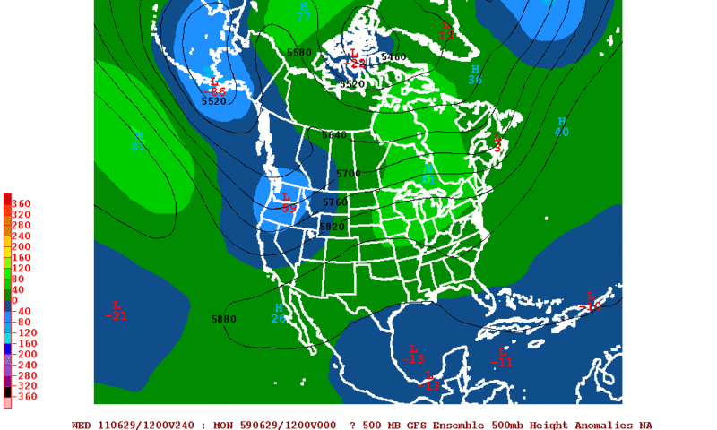
12zGFS and Euro Ensembles still forecasting lower than normal 500mb heights in the western gulf by the end of June.

Image

Image
0 likes   
The following post is NOT an official forecast and should not be used as such. It is just the opinion of the poster and may or may not be backed by sound meteorological data. It is NOT endorsed by any professional institution including storm2k.org For Official Information please refer to the NHC and NWS products.

Dean4Storms
S2K Supporter
S2K Supporter
Posts: 6358
Age: 62
Joined: Sun Aug 31, 2003 1:01 pm
Location: Miramar Bch. FL

#98 Postby Dean4Storms » Sun Jun 19, 2011 8:11 pm

Well at least it is becoming plausible that someone from TX to FL and anywhere in between is likely to see some good rainfall over the next couple of weeks. All these areas are experiencing drought and maybe if we get lucky everyone takes in some here or there!!
0 likes   

User avatar
gatorcane
S2K Supporter
S2K Supporter
Posts: 23691
Age: 47
Joined: Sun Mar 13, 2005 3:54 pm
Location: Boca Raton, FL

#99 Postby gatorcane » Sun Jun 19, 2011 8:16 pm

:uarrow: The NE extension of this Yucatan trough has created a good day of afternoon thundestorm activity across parts of interior Central Florida and over a widespread area of South Florida, helping the drought conditions in these areas.
0 likes   

User avatar
Rgv20
S2K Supporter
S2K Supporter
Posts: 2466
Age: 39
Joined: Wed Jan 05, 2011 5:42 pm
Location: Edinburg/McAllen Tx

#100 Postby Rgv20 » Mon Jun 20, 2011 12:46 am

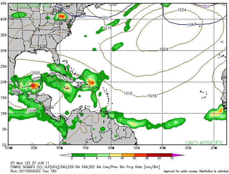
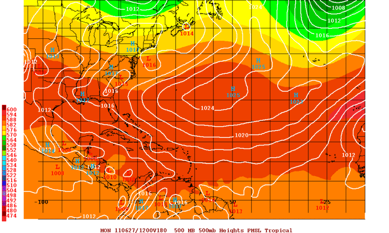
0zGFS and Nogaps agree on a broad low around the yucatan in the 180hr mark that would put it on Monday 06/27.

0zNogaps
Image

0zGFS
Image

Sorry for the double post but I thought I was posting in this thread instead of Global Model runs discussion. :double:
0 likes   
The following post is NOT an official forecast and should not be used as such. It is just the opinion of the poster and may or may not be backed by sound meteorological data. It is NOT endorsed by any professional institution including storm2k.org For Official Information please refer to the NHC and NWS products.


Return to “Talkin' Tropics”

Who is online

Users browsing this forum: GCANE, Google Adsense [Bot] and 57 guests