TCFA ISSUED:
REMARKS: THE AREA OF CONVECTION PREVIOUSLY LOCATED NEAR 6.5N
139.3E IS NOW LOCATED NEAR 10.8N 135.5E, APPROXIMATELY 170 NM WEST-
NORTHWEST OF YAP. RECENT ANIMATED MULTISPECTRAL SATELLITE IMAGERY
SHOWS DEEP CONVECTION INCREASING NEAR A CONSOLIDATING LOW LEVEL
CIRCULATION CENTER (LLCC) ALSO EVIDENT IN A 192133Z SSMIS IMAGE. THE
DISTURBANCE IS PASSING THROUGH AN AREA OF LOW VERTICAL WIND SHEAR
AND VERY FAVORABLE UPPER-LEVEL OUTFLOW ENHANCED BY A TROPICAL UPPER
TROPOSPHERIC TROUGH (TUTT) CELL TO THE NORTHEAST. MAXIMUM SUSTAINED
SURFACE WINDS ARE ESTIMATED AT 15 TO 20 KNOTS. MINIMUM SEA LEVEL
PRESSURE IS ESTIMATED TO BE NEAR 1005 MB. BASED ON INCREASING
ORGANIZATION AND VERY FAVORABLE UPPER LEVEL SUPPORT, THE POTENTIAL
FOR THE DEVELOPMENT OF A SIGNIFICANT TROPICAL CYCLONE WITHIN THE
NEXT 24 HOURS IS UPGRADED TO HIGH.
WPAC: MEARI [Falcon] - Remnants
Moderator: S2k Moderators
-
StormingB81

- S2K Supporter

- Posts: 5676
- Age: 44
- Joined: Thu Aug 27, 2009 1:45 am
- Location: Rockledge, Florida
-
StormingB81
- S2K Supporter
- Posts: 5676
- Age: 44
- Joined: Thu Aug 27, 2009 1:45 am
- Location: Rockledge, Florida
-
RobWESTPACWX
- WestPACMet

- Posts: 1616
- Joined: Fri Sep 17, 2010 2:26 am
- Location: Tokyo, Japan
- Contact:
Re: WPAC: INVEST 99W
Here you go, I also got a video coming up right now, still uploading, I stated in it I wouldn't be surprised if a TCFA pops soon out of it, so here you go! Unfortunately its still uploading! Darn you slow internet today!

0 likes
Satellites, Charts and Forecasting tools for East Asia at WESTERNPACIFICWEATHER.COM
-
RobWESTPACWX
- WestPACMet
- Posts: 1616
- Joined: Fri Sep 17, 2010 2:26 am
- Location: Tokyo, Japan
- Contact:
Re: WPAC: INVEST 99W
And here is the video, I defiantly put a fluff peace in here today so you can skip over it, but also talk about 06W as well. Busy day I suppose. But my thoughts.
[youtube]http://www.youtube.com/watch?v=o_i1bPeNwDk[/youtube]
[youtube]http://www.youtube.com/watch?v=o_i1bPeNwDk[/youtube]
0 likes
Satellites, Charts and Forecasting tools for East Asia at WESTERNPACIFICWEATHER.COM
-
dexterlabio
- Category 5

- Posts: 3505
- Joined: Sat Oct 24, 2009 11:50 pm
Re: WPAC: INVEST 99W
^Rob, it says that the video is unavailable. 
0 likes
Personal Forecast Disclaimer:
The posts in this forum are NOT official forecast and should not be used as such. They are just the opinion of the poster and may or may not be backed by sound meteorological data. They are NOT endorsed by any professional institution or storm2k.org. For official information, please refer to the NHC and NWS products.
The posts in this forum are NOT official forecast and should not be used as such. They are just the opinion of the poster and may or may not be backed by sound meteorological data. They are NOT endorsed by any professional institution or storm2k.org. For official information, please refer to the NHC and NWS products.
-
RobWESTPACWX
- WestPACMet
- Posts: 1616
- Joined: Fri Sep 17, 2010 2:26 am
- Location: Tokyo, Japan
- Contact:
-
RobWESTPACWX
- WestPACMet
- Posts: 1616
- Joined: Fri Sep 17, 2010 2:26 am
- Location: Tokyo, Japan
- Contact:
-
StormingB81
- S2K Supporter
- Posts: 5676
- Age: 44
- Joined: Thu Aug 27, 2009 1:45 am
- Location: Rockledge, Florida
-
dexterlabio
- Category 5
- Posts: 3505
- Joined: Sat Oct 24, 2009 11:50 pm
Re: WPAC: INVEST 99W
I'm interested to see your video update about this invest, Rob. Maybe I'm just going to check on it later. Nice videos as always, and I'm a bit surprised that you know some local news from here. Maybe it's because of TFC lol. But they are really informative, by the way.
Looking on the satloops, the large mass of convection seems to start spinning already. (?)
Looking on the satloops, the large mass of convection seems to start spinning already. (?)
0 likes
Personal Forecast Disclaimer:
The posts in this forum are NOT official forecast and should not be used as such. They are just the opinion of the poster and may or may not be backed by sound meteorological data. They are NOT endorsed by any professional institution or storm2k.org. For official information, please refer to the NHC and NWS products.
The posts in this forum are NOT official forecast and should not be used as such. They are just the opinion of the poster and may or may not be backed by sound meteorological data. They are NOT endorsed by any professional institution or storm2k.org. For official information, please refer to the NHC and NWS products.
-
dexterlabio
- Category 5
- Posts: 3505
- Joined: Sat Oct 24, 2009 11:50 pm
I also think that this invest might just come first to snatch the next name away from 06W. 
0 likes
Personal Forecast Disclaimer:
The posts in this forum are NOT official forecast and should not be used as such. They are just the opinion of the poster and may or may not be backed by sound meteorological data. They are NOT endorsed by any professional institution or storm2k.org. For official information, please refer to the NHC and NWS products.
The posts in this forum are NOT official forecast and should not be used as such. They are just the opinion of the poster and may or may not be backed by sound meteorological data. They are NOT endorsed by any professional institution or storm2k.org. For official information, please refer to the NHC and NWS products.
-
RobWESTPACWX
- WestPACMet
- Posts: 1616
- Joined: Fri Sep 17, 2010 2:26 am
- Location: Tokyo, Japan
- Contact:
-
StormingB81
- S2K Supporter
- Posts: 5676
- Age: 44
- Joined: Thu Aug 27, 2009 1:45 am
- Location: Rockledge, Florida
-
RobWESTPACWX
- WestPACMet
- Posts: 1616
- Joined: Fri Sep 17, 2010 2:26 am
- Location: Tokyo, Japan
- Contact:
Re: WPAC: INVEST 99W
StormingB81 wrote:Well I am going to one of the islands this weekend so watch this ruin my plans..
What Island are you going to? And yes, it just might, don't worry I'm heading south this week too...
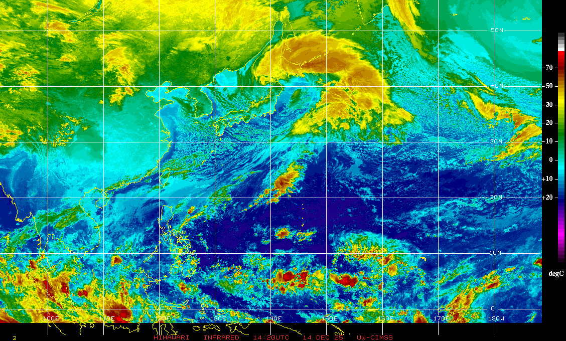
Here is a global view showing how large this system is right now.

0 likes
Satellites, Charts and Forecasting tools for East Asia at WESTERNPACIFICWEATHER.COM

-
StormingB81
- S2K Supporter
- Posts: 5676
- Age: 44
- Joined: Thu Aug 27, 2009 1:45 am
- Location: Rockledge, Florida
-
StormingB81
- S2K Supporter
- Posts: 5676
- Age: 44
- Joined: Thu Aug 27, 2009 1:45 am
- Location: Rockledge, Florida
http://www.emc.ncep.noaa.gov/gmb/tpm/em ... single.gif
I usually go on this site to look at the forecast but it hasnt been working in a couple of days...anyone else?
I usually go on this site to look at the forecast but it hasnt been working in a couple of days...anyone else?
0 likes
Enjoyed the fluff piece, Rob. Happy Father's Day!
12Z JMA analysis:
LOW PRESSURE AREA 1008 HPA NEAR 10N 136E WNW 10 KT.
20110620.1432.mtsat2.x.ir1km.99WINVEST.20kts-1007mb-118N-1332E.100pc.jpg

From NWS Guam's AFD:
.WESTERN MICRONESIA...
WEATHER CONDITIONS NEAR YAP AND PALAU REMAIN UNDER THE INFLUENCE
OF 99W..THE CIRCULATION NOW W-NW OF YAP AND THE SUBJECT OF A JTWC
TROPICAL CYCLONE FORMATION ALERT...AND A MONSOON TROUGH STRETCHING
SOUTHWESTWARD FROM THE CIRCULATION. SHOWERS WILL LIKELY CONTINUE
TO DEVELOP SE OF THE CIRCULATION WITH SCATTERED SHOWERS EXPECTED
AT PALAU POSSIBLY THROUGH WED AND AT YAP FROM TUE NIGHT THROUGH
WED NIGHT. NW WINDS WILL GRADUALLY BACK TO SW THROUGH WED AND STAY
BETWEEN 15 AND 20 KNOTS. WAVE WATCH MODEL INDICATES SEAS WILL
QUICKLY BUILD FROM 6 TO 7 FEET TONIGHT AND TUE TO 7 TO 9 FEET BY
TUE NIGHT. THIS WILL BE THE MOST LIKELY SCENARIO IF 99W DEVELOPS
ADDITIONALLY BEFORE MOVING AWAY IN THE COMING DAYS...AND A HIGH
SURF ADVISORY COULD BE NEEDED BY TUE NIGHT AT PALAU FOR WEST
FACING REEFS. ALSO...15 TO 20 KNOT WESTERLY WINDS BETWEEN 2N AND
7N MAY CAUSE LOCALIZED FLOODING ALONG WEST- FACING LAGOON BEACHES
OF ATOLLS LOCATED IN SOUTHERN PORTIONS OF THE REPUBLIC OF PALAU
AND YAP STATE THROUGH TUE NIGHT.
ASCAT missed but clear circulation:

Storming, I've had trouble with the site too. They moved to http://www.emc.ncep.noaa.gov/mmb/gplou/emchurr/glblgen/index.html, but the interface is not as convenient as the other site. Here are the 00Z model scatterplot from earlier. Hope this won't affect your vacation.

12Z JMA analysis:
LOW PRESSURE AREA 1008 HPA NEAR 10N 136E WNW 10 KT.
20110620.1432.mtsat2.x.ir1km.99WINVEST.20kts-1007mb-118N-1332E.100pc.jpg
From NWS Guam's AFD:
.WESTERN MICRONESIA...
WEATHER CONDITIONS NEAR YAP AND PALAU REMAIN UNDER THE INFLUENCE
OF 99W..THE CIRCULATION NOW W-NW OF YAP AND THE SUBJECT OF A JTWC
TROPICAL CYCLONE FORMATION ALERT...AND A MONSOON TROUGH STRETCHING
SOUTHWESTWARD FROM THE CIRCULATION. SHOWERS WILL LIKELY CONTINUE
TO DEVELOP SE OF THE CIRCULATION WITH SCATTERED SHOWERS EXPECTED
AT PALAU POSSIBLY THROUGH WED AND AT YAP FROM TUE NIGHT THROUGH
WED NIGHT. NW WINDS WILL GRADUALLY BACK TO SW THROUGH WED AND STAY
BETWEEN 15 AND 20 KNOTS. WAVE WATCH MODEL INDICATES SEAS WILL
QUICKLY BUILD FROM 6 TO 7 FEET TONIGHT AND TUE TO 7 TO 9 FEET BY
TUE NIGHT. THIS WILL BE THE MOST LIKELY SCENARIO IF 99W DEVELOPS
ADDITIONALLY BEFORE MOVING AWAY IN THE COMING DAYS...AND A HIGH
SURF ADVISORY COULD BE NEEDED BY TUE NIGHT AT PALAU FOR WEST
FACING REEFS. ALSO...15 TO 20 KNOT WESTERLY WINDS BETWEEN 2N AND
7N MAY CAUSE LOCALIZED FLOODING ALONG WEST- FACING LAGOON BEACHES
OF ATOLLS LOCATED IN SOUTHERN PORTIONS OF THE REPUBLIC OF PALAU
AND YAP STATE THROUGH TUE NIGHT.
ASCAT missed but clear circulation:
Storming, I've had trouble with the site too. They moved to http://www.emc.ncep.noaa.gov/mmb/gplou/emchurr/glblgen/index.html, but the interface is not as convenient as the other site. Here are the 00Z model scatterplot from earlier. Hope this won't affect your vacation.
0 likes
JTWC 18Z satellite bulletin shows continued development:
TPPN11 PGTW 201832
A. TROPICAL DISTURBANCE 99W (NE OF PALAU)
B. 20/1732Z
C. 11.1N
D. 132.0E
E. FIVE/MTSAT
F. T1.5/1.5/D0.5/18HRS STT: S0.0/06HRS
G. IR/EIR
H. REMARKS: 38A/PBO SBC/ANMTN. LOG10 YIELDS .30 WRAP, RESULTING
IN 1.5 DT. PT COMES TO 2.0. DT USED TO DETERMINE FT.
I. ADDITIONAL POSITIONS: NONE
SMITH
0 likes


-
StormingB81
- S2K Supporter
- Posts: 5676
- Age: 44
- Joined: Thu Aug 27, 2009 1:45 am
- Location: Rockledge, Florida
Who is online
Users browsing this forum: No registered users and 45 guests