Gulf Disturbance Week of June 27th (Is invest 95L)
Moderator: S2k Moderators
Forum rules

The posts in this forum are NOT official forecasts and should not be used as such. They are just the opinion of the poster and may or may not be backed by sound meteorological data. They are NOT endorsed by any professional institution or STORM2K. For official information, please refer to products from the National Hurricane Center and National Weather Service.
-
Rgv20

- S2K Supporter

- Posts: 2466
- Age: 39
- Joined: Wed Jan 05, 2011 5:42 pm
- Location: Edinburg/McAllen Tx
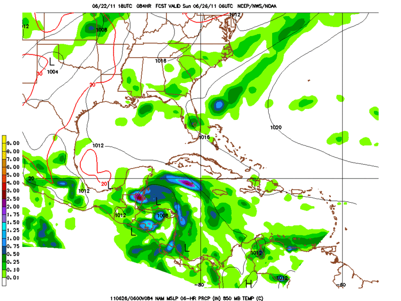
Even the 18zNam jumping on the bandwagon.
0 likes
The following post is NOT an official forecast and should not be used as such. It is just the opinion of the poster and may or may not be backed by sound meteorological data. It is NOT endorsed by any professional institution including storm2k.org For Official Information please refer to the NHC and NWS products.
-
plasticup
Re:
BigB0882 wrote:The only thing I am sure of is that if anything does form, it will not hit anywhere near the TX/MX border. I never know where a storm will hit far out but I do know it wont hit where initially predicted.
THIS IS NOT A FORECAST!
Hurricane Dean's Cat 5 landfall was predicted within 50 miles more than a week in advance.
The models get better every year. I wouldn't bet the farm on a 168 hour GFS run, but I wouldn't dismiss it either. These things verify, to some degree, more often than we give them credit for. My money is on something rumbling through the Gulf next week. It may not be a big ol' 'cane like GFS says, but I'm confident that there will be something interesting.
edit: this wave develops in all global models: GFS, CMC, EURO, NOGAPS, and HWRF. No outliers.
Last edited by plasticup on Wed Jun 22, 2011 9:17 pm, edited 2 times in total.
0 likes
-
Dean4Storms
- S2K Supporter
- Posts: 6358
- Age: 62
- Joined: Sun Aug 31, 2003 1:01 pm
- Location: Miramar Bch. FL
Saw some LL rotation right before sunset over eastern MX and now covered in convection. Wonder what happens if it moves offshore?
http://www.ssd.noaa.gov/goes/east/gmex/flash-vis.html
http://www.ssd.noaa.gov/goes/east/gmex/flash-vis.html
0 likes
-
lrak

- S2K Supporter
- Posts: 1770
- Age: 59
- Joined: Thu Jun 21, 2007 2:48 pm
- Location: Corpus Christi, TX
Re: Possible Gulf Disturbance
I was wondering the same thing.
0 likes
AKA karl
Also
Personal Forecast Disclaimer:
My posts on this forum are NOT official forecast and should not be used as such. My posts are my basic observations and are definitely not backed by any "well some" meteorological knowledge. For official information, please refer to the NHC and NWS products.
Also
Personal Forecast Disclaimer:
My posts on this forum are NOT official forecast and should not be used as such. My posts are my basic observations and are definitely not backed by any "well some" meteorological knowledge. For official information, please refer to the NHC and NWS products.

Re: Possible Gulf Disturbance
Yeah another 75 mies east and those models might have been correct, but at least we are getting some rain
http://radar.weather.gov/ridge/radar.ph ... 1&loop=yes
0 likes
The following post is NOT an official forecast and should not be used as such. It is just the opinion of the poster and may or may not be backed by sound meteorological data. It is NOT endorsed by any professional institution including storm2k.org For Official Information please refer to the NHC and NWS products.
-
Janie2006

- Category 5

- Posts: 1329
- Joined: Mon Sep 18, 2006 3:28 pm
- Location: coastal Ms aka home of the hurricanes
Re: Possible Gulf Disturbance
It was rather interesting to note the MCS move off the Texas coast earlier today and see what (if anything) might happen. There were some interesting pressure drops and low-level convergence, but nothing to write home about. Ah, well. At least people got some good rain.
Let the model roulette wheel continue its spin.
Let the model roulette wheel continue its spin.
0 likes
-
CYCLONE MIKE
- Category 5
- Posts: 2183
- Joined: Tue Aug 31, 2004 6:04 pm
- Location: Gonzales, LA
Re: Possible Gulf Disturbance
Yes indeed tailgater, at least we are getting rain. Have not been able to work near as much this month due to the drought, now can't work due to the rain. Just can't win against Mother Nature. The grass in my backyard has literally grown a couple of inches this week due to rain. Last week the back half of my backyard that the water sprinklers can't reach was brown now its thick and green. Next week is going to be back to normal with our friendly ridge setting up over us once again. 
Tailgater, little off topic but where in st amant do you live? I have a couple of employees that live out in your area along with a property I have been clearing out this month off 22 near fisherman 1 stop
Tailgater, little off topic but where in st amant do you live? I have a couple of employees that live out in your area along with a property I have been clearing out this month off 22 near fisherman 1 stop
0 likes
-
PTrackerLA

- Category 5
- Posts: 5280
- Age: 42
- Joined: Thu Oct 10, 2002 8:40 pm
- Location: Lafayette, LA
Re: Possible Gulf Disturbance
Kinda makes you wonder if watering (the grass that is) isn't really worth it huh? Amazing how much everything has greened up just by this evening from the past two days of rain. Some nice convection going over the western gulf tonight. It will be interesting to see what this area looks like tomorrow with most of the rain focusing offshore.
http://www.ssd.noaa.gov/goes/east/gmex/flash-avn.html
http://www.ssd.noaa.gov/goes/east/gmex/flash-avn.html
0 likes
-
Annie Oakley

- Category 5
- Posts: 1103
- Joined: Tue Jul 31, 2007 12:54 pm
- Location: Texas
-
CYCLONE MIKE
- Category 5
- Posts: 2183
- Joined: Tue Aug 31, 2004 6:04 pm
- Location: Gonzales, LA
Re: Possible Gulf Disturbance
Agreed PT. By the time my yard dries out enough I will have to mow over it three or four times to clean it up so it looks nice. I'm watching the area in the gulf, not for any tropical development, but for more rain coming up this way. Our local OCM thinks it will stay offshore but watching it on radar the rain shield sure looks to be moving NE up the texas coast in our direction. I'm guessing it will die out overnight as it gets close to us during the early morning hours though.
0 likes
-
Rgv20
- S2K Supporter
- Posts: 2466
- Age: 39
- Joined: Wed Jan 05, 2011 5:42 pm
- Location: Edinburg/McAllen Tx
0zGFS a tad further south than earlier runs.
Forecast for 06/28 Tuesday morning.
Forecast for 06/28 Tuesday morning.
0 likes
The following post is NOT an official forecast and should not be used as such. It is just the opinion of the poster and may or may not be backed by sound meteorological data. It is NOT endorsed by any professional institution including storm2k.org For Official Information please refer to the NHC and NWS products.
-
Rgv20
- S2K Supporter
- Posts: 2466
- Age: 39
- Joined: Wed Jan 05, 2011 5:42 pm
- Location: Edinburg/McAllen Tx
Looking at the all available guidance it looks like Sunday to Monday will be the time frame for a tropical disturbance to start taking shape.
0 likes
The following post is NOT an official forecast and should not be used as such. It is just the opinion of the poster and may or may not be backed by sound meteorological data. It is NOT endorsed by any professional institution including storm2k.org For Official Information please refer to the NHC and NWS products.
-
Rgv20
- S2K Supporter
- Posts: 2466
- Age: 39
- Joined: Wed Jan 05, 2011 5:42 pm
- Location: Edinburg/McAllen Tx
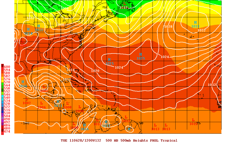
0zCMC at 144hrs has the system in the Southern Gulf.
Its going to be interesting what the 0zEuro shows later tonight.
Its going to be interesting what the 0zEuro shows later tonight.
0 likes
The following post is NOT an official forecast and should not be used as such. It is just the opinion of the poster and may or may not be backed by sound meteorological data. It is NOT endorsed by any professional institution including storm2k.org For Official Information please refer to the NHC and NWS products.


-
Texas Snowman

- Storm2k Moderator

- Posts: 6182
- Joined: Fri Jan 25, 2008 11:29 am
- Location: Denison, Texas
Re: Possible Gulf Disturbance
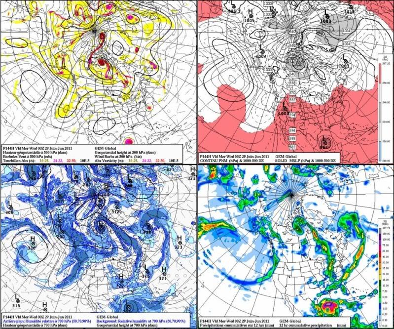
Hmmm...the crazy Uncle Canadian goes crazy....
Ivanhater wrote:Another view of the Canadian
0 likes
The above post and any post by Texas Snowman is NOT an official forecast and should not be used as such. It is just the opinion of the poster and may or may not be backed by sound meteorological data. It is NOT endorsed by any professional institution including storm2k.org. For official information, please refer to NWS products.
-
srainhoutx

- S2K Supporter
- Posts: 6919
- Age: 68
- Joined: Sun Jan 14, 2007 11:34 am
- Location: Haywood County, NC
- Contact:
Re: Possible Gulf Disturbance
The 00Z Euro Operational and Ensembles have a bit better organized system that is a slightly further N.
0 likes
Carla/Alicia/Jerry(In The Eye)/Michelle/Charley/Ivan/Dennis/Katrina/Rita/Wilma/Ike/Harvey
Member: National Weather Association
Wx Infinity Forums
http://wxinfinity.com/index.php
Facebook.com/WeatherInfinity
Twitter @WeatherInfinity
Member: National Weather Association
Wx Infinity Forums
http://wxinfinity.com/index.php
Facebook.com/WeatherInfinity
Twitter @WeatherInfinity
-
cycloneye

- Admin

- Posts: 148734
- Age: 69
- Joined: Thu Oct 10, 2002 10:54 am
- Location: San Juan, Puerto Rico
Re: Possible Gulf Disturbance
From NHC:
MARINE WEATHER DISCUSSION
NWS NATIONAL HURRICANE CENTER MIAMI FL
300 AM EDT THU JUN 23 2011
GULF OF MEXICO...
A RIDGE OF HIGH PRESSURE WILL GENERALLY PREVAIL ACROSS THE AREA
THROUGH THE FORECAST PERIOD. SE RETURN FLOW WILL PREVAIL OVER
THE WESTERN GULF. THE TROPICAL WAVE IN THE EASTERN
CARIBBEAN...MENTIONED BELOW IN THE CARIBBEAN SECTION...WILL MOVE
INTO THE GULF OF MEXICO MONDAY. NE WINDS AHEAD OF THE TROPICAL
WAVE WILL INCREASE OVER THE SOUTHERN PART OF THE GULF SUNDAY.
MODELS CONTINUE TO BE BULLISH WITH THE POTENTIAL DEVELOPMENT OF
THIS WAVE IN THE SW GULF.
Michael, I think this thread will be locked in a few days.
0 likes
Visit the Caribbean-Central America Weather Thread where you can find at first post web cams,radars
and observations from Caribbean basin members Click Here
and observations from Caribbean basin members Click Here
-
Dean4Storms
- S2K Supporter
- Posts: 6358
- Age: 62
- Joined: Sun Aug 31, 2003 1:01 pm
- Location: Miramar Bch. FL
-
plasticup
Re: Possible Gulf Disturbance
The southern gulf doesn't have a particularly high heat potential at the moment. I can't see something blowing up like the Canadian model suggests.

0 likes
Who is online
Users browsing this forum: No registered users and 60 guests