

Gulf Disturbance Week of June 27th (Is invest 95L)
Moderator: S2k Moderators
Forum rules

The posts in this forum are NOT official forecasts and should not be used as such. They are just the opinion of the poster and may or may not be backed by sound meteorological data. They are NOT endorsed by any professional institution or STORM2K. For official information, please refer to products from the National Hurricane Center and National Weather Service.

-
South Texas Storms

- Professional-Met

- Posts: 4246
- Joined: Thu Jun 24, 2010 12:28 am
- Location: Houston, TX
Re: Possible Gulf Disturbance (Next week)
0 likes
-
HURAKAN

- Professional-Met
- Posts: 46086
- Age: 38
- Joined: Thu May 20, 2004 4:34 pm
- Location: Key West, FL
- Contact:
Re: Possible Gulf Disturbance (Next week)
South Texas Storms wrote: but it looks like it develops another system in the SW gulf in about 7 days.
True, something new from the GFS .... wait a minute, hasn't this been the forecast since a few weeks ago? lol
0 likes
-
South Texas Storms
- Professional-Met
- Posts: 4246
- Joined: Thu Jun 24, 2010 12:28 am
- Location: Houston, TX
Re: Possible Gulf Disturbance (Next week)
HURAKAN wrote:South Texas Storms wrote: but it looks like it develops another system in the SW gulf in about 7 days.
True, something new from the GFS .... wait a minute, hasn't this been the forecast since a few weeks ago? lol
Haha yeah one of these systems are gonna develop, right?
0 likes
-
Rgv20

- S2K Supporter

- Posts: 2466
- Age: 39
- Joined: Wed Jan 05, 2011 5:42 pm
- Location: Edinburg/McAllen Tx
12zECMWF Ensembles have the low tracking further north in the GOM then the operational run.
Tuesday morning.
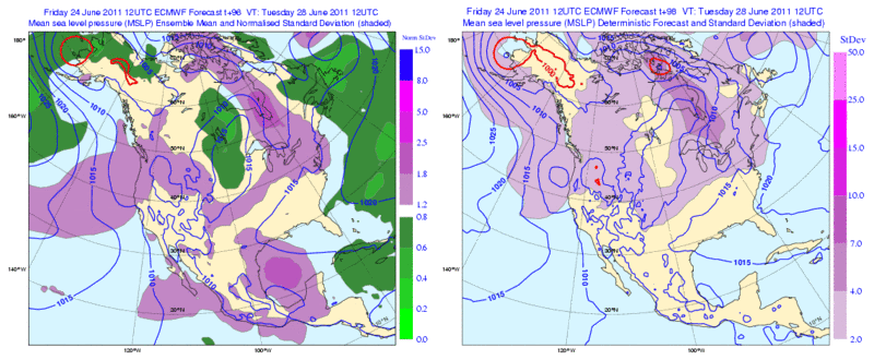
Tuesday morning.
0 likes
The following post is NOT an official forecast and should not be used as such. It is just the opinion of the poster and may or may not be backed by sound meteorological data. It is NOT endorsed by any professional institution including storm2k.org For Official Information please refer to the NHC and NWS products.
-
Rgv20
- S2K Supporter
- Posts: 2466
- Age: 39
- Joined: Wed Jan 05, 2011 5:42 pm
- Location: Edinburg/McAllen Tx
San Andres Island has had a calm to variable winds through out the day..maybe a sign of a developing low??
http://weather.noaa.gov/weather/current/SKSP.html
http://weather.noaa.gov/weather/current/SKSP.html
0 likes
The following post is NOT an official forecast and should not be used as such. It is just the opinion of the poster and may or may not be backed by sound meteorological data. It is NOT endorsed by any professional institution including storm2k.org For Official Information please refer to the NHC and NWS products.
-
stormreader
Re: Possible Gulf Disturbance (Next week)
NHC does mention broad cyclonic turning in the Gulf.
AN UPPER TROUGH EXTENDS ITS AXIS ACROSS THE ERN AND SE CONUS TO
SOUTHERN TEXAS. CONTRASTINGLY...AN UPPER RIDGE SITS OVER CENTRAL
MEXICO EXTENDING ITS AXIS EASTWARD ACROSS THE GULF AND THE
FLORIDA PENINSULA INTO THE WEST ATLC OCEAN. THESE TWO FEATURES
ARE GENERATING AN AREA OF DIFFLUENCE ALOFT SUPPORTING SCATTERED
MODERATE TO HEAVY SHOWERS AND THUNDERSTORMS WITHIN 100 TO 120 NM
ON EITHER SIDE OF A LINE EXTENDING FROM NEAR 28N856 TO 22N96W. A
RECENT ASCAT PASS COMBINED WITH MARINE OBS ACROSS THE GULF SH
WED BROAD CYCLONIC TURN 15-25 KT ALONG THE LINE.
0 likes

Re: Possible Gulf Disturbance (Next week)
GFS is at it again. I guess we'll just have wait till we actually have a closed low confirmed by RECON.
I'm sure the 00 run will show something totally different.
I'm sure the 00 run will show something totally different.
0 likes
The following post is NOT an official forecast and should not be used as such. It is just the opinion of the poster and may or may not be backed by sound meteorological data. It is NOT endorsed by any professional institution including storm2k.org For Official Information please refer to the NHC and NWS products.
-
CYCLONE MIKE
- Category 5

- Posts: 2183
- Joined: Tue Aug 31, 2004 6:04 pm
- Location: Gonzales, LA
Re: Possible Gulf Disturbance (Next week)
Tomorrow will probably show it hitting around Corpus or even further north  I'm sure if this "phantom" storm doesn't pan out give it another day and the GFS will show another one developing in the gulf in another 6-8 days. Maybe in July it will actually get something right, then again... Have to give it credit for two things so far this season: persistence and determination
0 likes
-
Rgv20
- S2K Supporter
- Posts: 2466
- Age: 39
- Joined: Wed Jan 05, 2011 5:42 pm
- Location: Edinburg/McAllen Tx
The 12z & 18z GFS Ensembles are hinting that IF something were to develop it still could go further north than the operational runs.
Here is the MSLP spread for Friday morning 07/01 when the HPC has Low pressure over Tampico Mx.
12z

18z
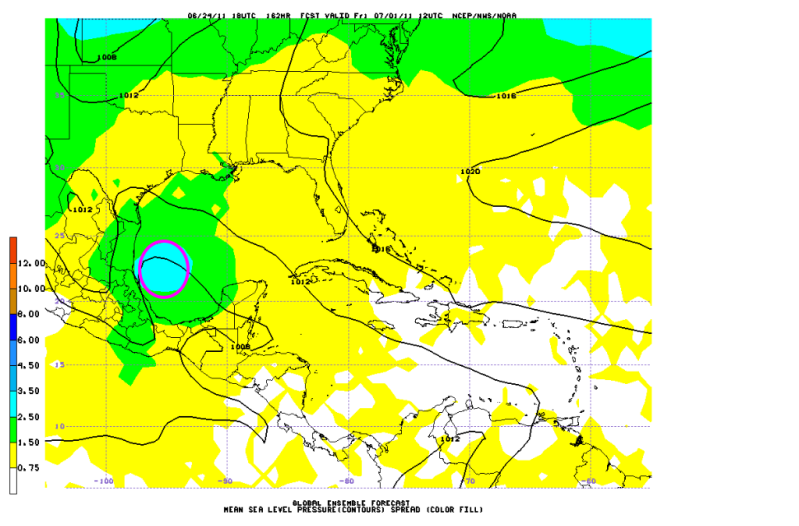
Here is the MSLP spread for Friday morning 07/01 when the HPC has Low pressure over Tampico Mx.
12z
18z
0 likes
The following post is NOT an official forecast and should not be used as such. It is just the opinion of the poster and may or may not be backed by sound meteorological data. It is NOT endorsed by any professional institution including storm2k.org For Official Information please refer to the NHC and NWS products.
-
Rainband
Re: Possible Gulf Disturbance (Next week)
tailgater wrote:GFS is at it again. I guess we'll just have wait till we actually have a closed low confirmed by RECON.
I'm sure the 00 run will show something totally different.
what recon??
0 likes
-
CYCLONE MIKE
- Category 5
- Posts: 2183
- Joined: Tue Aug 31, 2004 6:04 pm
- Location: Gonzales, LA
Re: Possible Gulf Disturbance (Next week)
Not speaking for tailgater but think he was just being a little sarcastic.
0 likes
-
HURAKAN
- Professional-Met
- Posts: 46086
- Age: 38
- Joined: Thu May 20, 2004 4:34 pm
- Location: Key West, FL
- Contact:
Re: Possible Gulf Disturbance (Next week)

We got Jim for dissipating systems and for the current GFS, we got "Sleepy" .. lol
0 likes
Re: Possible Gulf Disturbance (Next week)
Rainband wrote:tailgater wrote:GFS is at it again. I guess we'll just have wait till we actually have a closed low confirmed by RECON.
I'm sure the 00 run will show something totally different.
what recon??
Yeah just saying, I'll beleive it when I see it, these models aren't preforming to well (formation wise) maybe they'll do better with tracking and intensity!
0 likes
The following post is NOT an official forecast and should not be used as such. It is just the opinion of the poster and may or may not be backed by sound meteorological data. It is NOT endorsed by any professional institution including storm2k.org For Official Information please refer to the NHC and NWS products.

Re: Possible Gulf Disturbance (Next week)
center reformations will be key here. Well that is if it does form a LLC....
wait and see time...
wait and see time...
0 likes
-
Pearl River

- S2K Supporter
- Posts: 825
- Age: 66
- Joined: Fri Dec 09, 2005 6:07 pm
- Location: SELa
Re: Possible Gulf Disturbance (Next week)
New Orleans this morning:
AREA FORECAST DISCUSSION
NATIONAL WEATHER SERVICE NEW ORLEANS LA
424 AM CDT SAT JUN 25 2011
.LONG TERM...
LOCALLY...A PERSISTENCE OF BERMUDA RIDGE REGIME FOR THE MOST PART
THOUGH A WEAK UPPER LEVEL TROUGH AND SURFACE REFLECTION TROUGH MAY
SETTLE INTO THE REGION WEDNESDAY TO PERHAPS ENHANCE RAIN CHANCES A
BIT ALONG A BETTER SYNOPTIC SCALE FOCUS...PER THE GFS. THE GFS
ALSO CONTINUES TO WAVER WITH EACH RUN ON LOW PRESSURE CYCLOGENESIS
IN THE SOUTHWEST GULF OF MEXICO LATTER PART OF NEXT WEEK INTO THE
INDEPENDENCE DAY WEEKEND. THIS STILL LOOKS SUSPECT AND POSSIBLY A
MODEL ARTIFACT WITHIN THE GFS AS THE ECMWF AND DGEX DISCOUNT SUCH
A FEATURE. FROM A TELECONNECTION APPROACH...THE SOUTHWEST GULF OF
MEXICO WILL BE MORE CONDUCIVE FOR LOW PRESSURE DEVELOPMENT BUT
WILL BE LIMITED IN AREAL EXTENT OF NON-HOSTILE CONDITIONS...
PRIMARILY PINNED ALONG THE MEXICAN COAST AS SHEAR WOULD BE MORE
PRONOUNCED ALONG WITH CONTINENTAL DRY FETCH FARTHER NORTH.
0 likes
-
SETXWXLADY
- Tropical Storm

- Posts: 216
- Joined: Wed May 20, 2009 3:26 pm
- Location: SE TX Orange County
Re: Possible Gulf Disturbance (Next week)
Pearl River wrote:New Orleans this morning:
AREA FORECAST DISCUSSION
NATIONAL WEATHER SERVICE NEW ORLEANS LA
424 AM CDT SAT JUN 25 2011
.LONG TERM...
LOCALLY...A PERSISTENCE OF BERMUDA RIDGE REGIME FOR THE MOST PART
THOUGH A WEAK UPPER LEVEL TROUGH AND SURFACE REFLECTION TROUGH MAY
SETTLE INTO THE REGION WEDNESDAY TO PERHAPS ENHANCE RAIN CHANCES A
BIT ALONG A BETTER SYNOPTIC SCALE FOCUS...PER THE GFS. THE GFS
ALSO CONTINUES TO WAVER WITH EACH RUN ON LOW PRESSURE CYCLOGENESIS
IN THE SOUTHWEST GULF OF MEXICO LATTER PART OF NEXT WEEK INTO THE
INDEPENDENCE DAY WEEKEND. THIS STILL LOOKS SUSPECT AND POSSIBLY A
MODEL ARTIFACT WITHIN THE GFS AS THE ECMWF AND DGEX DISCOUNT SUCH
A FEATURE. FROM A TELECONNECTION APPROACH...THE SOUTHWEST GULF OF
MEXICO WILL BE MORE CONDUCIVE FOR LOW PRESSURE DEVELOPMENT BUT
WILL BE LIMITED IN AREAL EXTENT OF NON-HOSTILE CONDITIONS...
PRIMARILY PINNED ALONG THE MEXICAN COAST AS SHEAR WOULD BE MORE
PRONOUNCED ALONG WITH CONTINENTAL DRY FETCH FARTHER NORTH.
Yeah, the 6z GFS shows a storm going thru TX/LA around 300hrs. Good explanation on why the other models aren't showing that. Thanks.

0 likes
Re: Possible Gulf Disturbance (Next week)
Nothing in the Gulf this morning except for lots of cirrus debris - active convection in the SW Caribbean, however, though the GFS shows that crossing Central America...
Lots of cloud cover here in South Florida this morning, too - we had a nice halo around the sun for several hours yesterday morning, as well..
Lots of cloud cover here in South Florida this morning, too - we had a nice halo around the sun for several hours yesterday morning, as well..
0 likes
-
stormreader
Well if something does materialize in the SW Gulf (and thats a very big if) I think it may be in conjunction with weather (the wave) now located in the Western Caribbean Sea. The Hurricane Center says that much of this convection will move into the NW Carribean. We'll see if this doesn't make its way into the Bay of Campeche by Tue-Wed of next week.
0 likes
Who is online
Users browsing this forum: No registered users and 75 guests