ATL: ARLENE - Remnants
Moderator: S2k Moderators
- HURAKAN
- Professional-Met

- Posts: 46084
- Age: 39
- Joined: Thu May 20, 2004 4:34 pm
- Location: Key West, FL
- Contact:
Re: ATL: INVEST 95L - Discussion
TROPICAL WEATHER DISCUSSION
NWS NATIONAL HURRICANE CENTER MIAMI FL
805 PM EDT MON JUN 27 2011
BROAD AREA OF LOW PRESSURE COVERS THE S GULF OF MEXICO WITH A
1007 MB SURFACE LOW LOCATED NEAR 19N92W WHICH IS E OF THE A
TROPICAL WAVE. THE UPPER TROUGH IS CURRENTLY TO THE NW OF THE
LOW LEVEL CENTER. A BROAD AREA OF DEEP LAYERED MOISTURE COVERS
THE S GULF AS DEPICTED BY TOTAL PRECIPITABLE WATER IMAGERY.
SCATTERED SHOWERS/ISOLATED THUNDERSTORMS COVER THE AREA S OF 22N
BETWEEN THE YUCATAN CHANNEL AND 97W BEING ENHANCED BY THE CLOSE
PROXIMITY OF THE TROPICAL WAVE AND THE UPPER TROUGH. THERE IS A
MEDIUM CHANCE OF THIS SYSTEM BECOMING A TROPICAL CYCLONE DURING
THE NEXT 48 HOURS AS IT MOVES SLOWLY WEST-NORTHWESTWARD.
REGARDLESS OF DEVELOPMENT...LOCALLY HEAVY RAINS AND GUSTY WINDS
ARE POSSIBLE OVER PORTIONS OF THE YUCATAN PENINSULA AND SE
MEXICO TONIGHT. THESE RAINS AND WINDS WILL GRADUALLY SPREAD
WESTWARD INTO NE MEXICO DURING THE NEXT DAY OR TWO.
0 likes
- wxman57
- Moderator-Pro Met

- Posts: 23174
- Age: 68
- Joined: Sat Jun 21, 2003 8:06 pm
- Location: Houston, TX (southwest)
Re: ATL: INVEST 95L - Discussion
Nothing has really changed in organization this afternoon. Don't agree with the 50% chance of development, but Stacey Stewart IS the most generous NHC forecaster with percentages. Surface obs do not indicate any LLC, even a broad one. Wind shear remains moderate from the WSW, as can easily be seen on all satellite loops. The only change I can see is that cloud tops have cooled over the SW Yucatan and extreme SE BoC this afternoon. But that's to be expected (over land) during the afternoon.


0 likes
- tropicwatch
- Category 5

- Posts: 3426
- Age: 62
- Joined: Sat Jun 02, 2007 10:01 am
- Location: The Villages, Florida
- Contact:
Re: ATL: INVEST 95L - Discussion
cycloneye wrote:Up to 50%
TROPICAL WEATHER OUTLOOK
NWS NATIONAL HURRICANE CENTER MIAMI FL
800 PM EDT MON JUN 27 2011
FOR THE NORTH ATLANTIC...CARIBBEAN SEA AND THE GULF OF MEXICO...
SATELLITE PICTURES AND SURFACE OBSERVATIONS SUGGEST THAT THE BROAD
AREA OF LOW PRESSURE OVER THE EASTERN BAY OF CAMPECHE IS GRADUALLY
BECOMING BETTER DEFINED. ALTHOUGH UPPER-LEVEL WINDS ARE NOT
CURRENTLY CONDUCIVE FOR SIGNIFICANT DEVELOPMENT...THESE WINDS ARE
FORECAST TO BECOME MORE FAVORABLE DURING THE NEXT DAY OR SO. THERE
IS A MEDIUM CHANCE...50 PERCENT...OF THIS SYSTEM BECOMING A
TROPICAL CYCLONE DURING THE NEXT 48 HOURS AS IT MOVES SLOWLY
WEST-NORTHWESTWARD. AN AIR FORCE RESERVE UNIT HURRICANE HUNTER
PLANE IS SCHEDULED TO INVESTIGATE THE AREA TUESDAY AFTERNOON...IF
NECESSARY. REGARDLESS OF DEVELOPMENT...LOCALLY HEAVY RAINS AND
GUSTY WINDS ARE POSSIBLE OVER PORTIONS OF THE YUCATAN PENINSULA AND
SOUTHEASTERN MEXICO TONIGHT. THESE RAINS AND WINDS WILL GRADUALLY
SPREAD WESTWARD INTO NORTHEASTERN MEXICO DURING THE NEXT DAY OR
TWO.
ELSEWHERE...TROPICAL CYCLONE FORMATION IS NOT EXPECTED DURING THE
NEXT 48 HOURS.
$$
FORECASTER KIMBERLAIN/STEWART
I am kind of surprised that a sat floater has not been activiated yet.
Tropicwatch
0 likes
Re:
NDG wrote:I agree with raising chances up to 50%, low pressure center starting to come together a little better just NE of Ciudad del Carmen, where pressure is now down to 1005mb.
I was right, 95L position for 00z models were started NE of Ciudad del Carmen
0 likes
- cycloneye
- Admin

- Posts: 149426
- Age: 69
- Joined: Thu Oct 10, 2002 10:54 am
- Location: San Juan, Puerto Rico
Re: ATL: INVEST 95L - Discussion
AL, 95, 2011062800, , BEST, 0, 194N, 916W, 20, 1006, DB
0 likes
Visit the Caribbean-Central America Weather Thread where you can find at first post web cams,radars
and observations from Caribbean basin members Click Here
and observations from Caribbean basin members Click Here
- cycloneye
- Admin

- Posts: 149426
- Age: 69
- Joined: Thu Oct 10, 2002 10:54 am
- Location: San Juan, Puerto Rico
Re: ATL: INVEST 95L - Models
Barely a TS.
Code: Select all
WHXX01 KWBC 280023
CHGHUR
TROPICAL CYCLONE GUIDANCE MESSAGE
NWS NATIONAL HURRICANE CENTER MIAMI FL
0023 UTC TUE JUN 28 2011

DISCLAIMER...NUMERICAL MODELS ARE SUBJECT TO LARGE ERRORS.
PLEASE REFER TO NHC OFFICIAL FORECASTS FOR TROPICAL CYCLONE
AND SUBTROPICAL CYCLONE INFORMATION.

ATLANTIC OBJECTIVE AIDS FOR

DISTURBANCE INVEST (AL952011) 20110628 0000 UTC

        ...00 HRS...   ...12 HRS...   ...24 HRS. ..   ...36 HRS...
        110628  0000   110628  1200   110629  0000   110629  1200

         LAT    LON     LAT    LON     LAT    LON     LAT    LON
BAMS    19.4N  91.6W   20.2N  93.6W   20.7N  95.3W   20.8N  96.9W
BAMD    19.4N  91.6W   20.2N  92.8W   20.8N  94.2W   21.1N  95.5W
BAMM    19.4N  91.6W   20.2N  93.2W   20.7N  94.8W   20.9N  96.3W
LBAR    19.4N  91.6W   20.1N  93.0W   21.3N  94.9W   22.2N  96.9W
SHIP        20KTS          25KTS          33KTS          39KTS
DSHP        20KTS          25KTS          33KTS          39KTS

        ...48 HRS...   ...72 HRS...   ...96 HRS. ..   ..120 HRS...
        110630  0000   110701  0000   110702  0000   110703  0000

         LAT    LON     LAT    LON     LAT    LON     LAT    LON
BAMS    20.9N  98.4W   21.2N 101.2W   21.4N 104.2W   21.9N 107.5W
BAMD    21.5N  97.2W   22.0N 100.7W   22.4N 104.2W   23.0N 107.6W
BAMM    21.1N  97.9W   21.2N 101.1W   21.2N 104.3W   21.6N 107.9W
LBAR    23.3N  99.0W   25.6N 103.2W   27.9N 106.9W   31.1N 109.9W
SHIP        43KTS          55KTS          66KTS          66KTS
DSHP        35KTS          28KTS          27KTS          27KTS

         ...INITIAL CONDITIONS...
LATCUR =  19.4N LONCUR =  91.6W DIRCUR = 290DEG SPDCUR =   5KT
LATM12 =  19.0N LONM12 =  90.3W DIRM12 = 290DEG SPDM12 =   6KT
LATM24 =  18.6N LONM24 =  89.3W
WNDCUR =   20KT RMAXWD =   60NM WNDM12 =   20KT
CENPRS = 1006MB OUTPRS = 1009MB OUTRAD =  180NM SDEPTH =   M
RD34NE =    0NM RD34SE =    0NM RD34SW =    0NM RD34NW =   0NM

$$
0 likes
Visit the Caribbean-Central America Weather Thread where you can find at first post web cams,radars
and observations from Caribbean basin members Click Here
and observations from Caribbean basin members Click Here
I expect 95L to start getting better organized as soon as tomorrow, as all models indicate better upper level conditions to start taking shape in the extreme southern BOC and spread a little northward into the western GOM by Wednesday.
What are the chances of upper level forecast not to pan out by the ECMWF, not very high. I stand by it, I feel very confident that I will not eat crow.
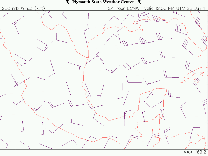
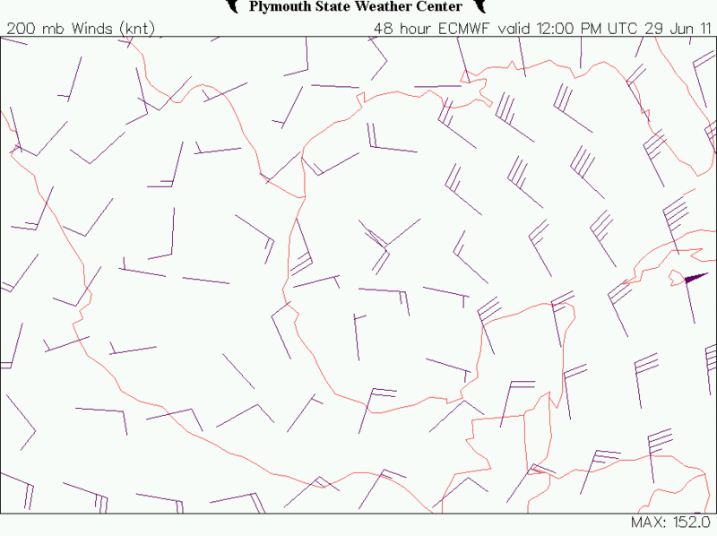
What are the chances of upper level forecast not to pan out by the ECMWF, not very high. I stand by it, I feel very confident that I will not eat crow.


0 likes
-
Dean4Storms
- S2K Supporter

- Posts: 6358
- Age: 63
- Joined: Sun Aug 31, 2003 1:01 pm
- Location: Miramar Bch. FL
Can make out a broad circulation in the lower cloud level before sunset, but very broad. If the convection was to deepen tonight with the Low offshore and with the upper level winds forecasted to become more conducive, then with that and the model support I can see giving it a 50% shot over the next 48 hours.
I'd have to ask, at what point over a period of 48 hours would you give a Tropical Wave a 50% chance at becoming a Depression? All it needs is a closed circulation basically.
I'd have to ask, at what point over a period of 48 hours would you give a Tropical Wave a 50% chance at becoming a Depression? All it needs is a closed circulation basically.
0 likes
- MGC
- S2K Supporter

- Posts: 5940
- Joined: Sun Mar 23, 2003 9:05 pm
- Location: Pass Christian MS, or what is left.
Re: ATL: INVEST 95L - Discussion
Looks to me that a ULL might be trying to form over the N GOM coast. If this happen it will only increase the shear over 95L which is currently high. I've seen system form under more hostile UL conditions but will be surprised if a TC forms before 95L runs out of water.......MGC
0 likes
-
JonathanBelles
- Professional-Met

- Posts: 11430
- Age: 35
- Joined: Sat Dec 24, 2005 9:00 pm
- Location: School: Florida State University (Tallahassee, FL) Home: St. Petersburg, Florida
- Contact:
Re: ATL: INVEST 95L - Discussion
The posts in this forum are NOT official forecast and should not be used as such. They are just the opinion of the poster and may or may not be backed by sound meteorological data. They are NOT endorsed by any professional institution or storm2k.org. For official information, please refer to the NHC and NWS products.
Looks like a slow climb toward TS Status and Arlene. I really do not see anything besides climatology that would suggest anything faster than that. My thoughts here: http://jonathanbelles.wordpress.com/201 ... -declared/
0 likes
- lester
- S2K Supporter

- Posts: 1305
- Age: 37
- Joined: Sat Aug 27, 2005 5:21 pm
- Location: Washington, DC
- Contact:
Re: ATL: INVEST 95L - Discussion
CLOUDINESS AND SHOWERS ACCOMPANYING A BROAD AREA OF LOW PRESSURE
OVER THE EASTERN BAY OF CAMPECHE HAVE CHANGED LITTLE IN
ORGANIZATION DURING THE PAST SEVERAL HOURS. ALTHOUGH UPPER-LEVEL
WINDS ARE NOT CURRENTLY CONDUCIVE FOR SIGNIFICANT DEVELOPMENT...
THESE WINDS ARE FORECAST TO GRADUALLY BECOME MORE FAVORABLE DURING
THE NEXT DAY OR SO. THERE IS A MEDIUM CHANCE...50 PERCENT...OF THIS
SYSTEM BECOMING A TROPICAL CYCLONE DURING THE NEXT 48 HOURS AS IT
MOVES WEST-NORTHWESTWARD AT 5 TO 10 MPH. AN AIR FORCE RESERVE UNIT
HURRICANE HUNTER PLANE IS SCHEDULED TO INVESTIGATE THE AREA TUESDAY
AFTERNOON...IF NECESSARY. REGARDLESS OF DEVELOPMENT...LOCALLY HEAVY
RAINS AND GUSTY WINDS ARE POSSIBLE OVER PORTIONS OF THE YUCATAN
PENINSULA AND SOUTHEASTERN MEXICO TODAY. THESE RAINS AND WINDS
WILL GRADUALLY SPREAD WESTWARD INTO NORTHEASTERN MEXICO DURING THE
NEXT DAY OR TWO.
0 likes
-
USTropics
- Professional-Met

- Posts: 2738
- Joined: Sun Aug 12, 2007 3:45 am
- Location: Florida State University
Re: ATL: INVEST 95L - Discussion
This is just my assumption on why the NHC has decided to go with an aggressive 50% chance for development in the next 48 hours for a system that remains disorganized/still interacting with land. First, whatever becomes of 95L appears to only have about a 48 hour window over open water before moving ashore over Mexico. Shear is expected to decrease from 30 knots to 10-20 knots through today (Tuesday). Recent history suggests a tropical system can organize and strengthen in this time frame given marginal/conducive environmental conditions, especially in this area (see Alex/Hermine-2010, Marco-2008, Erin/Humberto 2007). Also, quoting Jeff Master's blog from Monday, "the topography surrounding the Bay of Campeche tends to boost counter-clockwise air flow, enabling systems there to spin up faster than any other portion of the Atlantic." I see the reasoning behind giving 95L a 50/50 shot of forming into a tropical depression or tropical storm in the next 48 hours, especially considering when there is some consistent model support for development. It's better to error on the side of caution in this case, even if nothing ends up forming out of 95L.


0 likes
Re: ATL: INVEST 95L - Discussion
Looks like the issue is a little too much vorticity at 200mb which limits vertical expansion of the PV column.
This really needs a good hot-tower to snap the upper troposphere in shape.
Moderate shear and moderate instability could fire off Cu-Nims that may make it above 15km.
LI at -5, CAPE about 3000 and uncapped air saturated to H5.
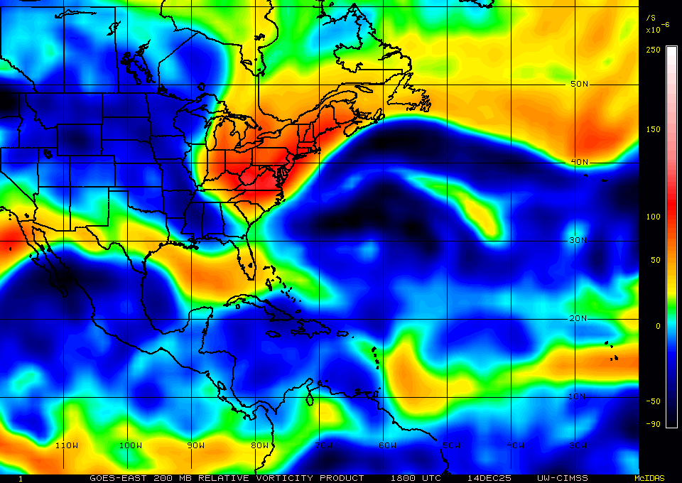


This really needs a good hot-tower to snap the upper troposphere in shape.
Moderate shear and moderate instability could fire off Cu-Nims that may make it above 15km.
LI at -5, CAPE about 3000 and uncapped air saturated to H5.


0 likes
- wxman57
- Moderator-Pro Met

- Posts: 23174
- Age: 68
- Joined: Sat Jun 21, 2003 8:06 pm
- Location: Houston, TX (southwest)
Re: ATL: INVEST 95L - Discussion
Moderate shear is still apparent on satellite loops. WSW-W winds aloft continue. Not much evidence of any LLC and convection remains weak. Probably nothing there to investigate with recon today. Best chance of development would be tomorrow, not long before it moves ashore.
0 likes
Re: ATL: INVEST 95L - Discussion
A strong cell has popped up and is firing close to the COC.
Usually an opportune time just around sunrise when UL temps are at their minimum.
http://rammb.cira.colostate.edu/product ... 280515.jpg


Usually an opportune time just around sunrise when UL temps are at their minimum.
http://rammb.cira.colostate.edu/product ... 280515.jpg

0 likes
Re: ATL: INVEST 95L - Discussion
Strong winds are shown on the surface.
Wind-Induced-Surface-Heat-Exchange (WISHE) may already be kicking in.

Wind-Induced-Surface-Heat-Exchange (WISHE) may already be kicking in.
0 likes
Waves up to 9' down in the BOC? Just a simple tropical disturbance will not kick 9' waves, pressure gradient is kicking winds up down there. With buoy 42055 reporting temps in the low 80s all night long, those winds are not outflow boundaries or from convection.
Conditions at 42055 as of
(5:50 am CDT)
Wind Direction (WDIR): E ( 80 deg true )
Wind Speed (WSPD): 19.4 kts
Wind Gust (GST): 25.3 kts
Wave Height (WVHT): 8.9 ft
Dominant Wave Period (DPD): 8 sec
Average Period (APD): 6.3 sec
Mean Wave Direction (MWD): ENE ( 78 deg true )
Atmospheric Pressure (PRES): 29.77 in
Pressure Tendency (PTDY): -0.02 in ( Falling )
Air Temperature (ATMP): 81.9 °F
Water Temperature (WTMP): 83.8 °F
Dew Point (DEWP): 75.9 °F
Heat Index (HEAT): 89.1 °F
0 likes
Re: ATL: INVEST 95L - Discussion
Code red 8 A.M. update anyone?
0 likes
"People might not get all they work for in this world, but they must certainly work for all they get."- Frederick Douglass
- cycloneye
- Admin

- Posts: 149426
- Age: 69
- Joined: Thu Oct 10, 2002 10:54 am
- Location: San Juan, Puerto Rico
Re: ATL: INVEST 95L - Models
00z HWRF has a weak TS making landfall around Tampico.
http://moe.met.fsu.edu/cgi-bin/hwrftc2. ... =Animation
http://moe.met.fsu.edu/cgi-bin/hwrftc2. ... =Animation
0 likes
Visit the Caribbean-Central America Weather Thread where you can find at first post web cams,radars
and observations from Caribbean basin members Click Here
and observations from Caribbean basin members Click Here
Who is online
Users browsing this forum: No registered users and 33 guests


