C/S TX Weather: Seasonal with some rains
Moderator: S2k Moderators
Forum rules

The posts in this forum are NOT official forecast and should not be used as such. They are just the opinion of the poster and may or may not be backed by sound meteorological data. They are NOT endorsed by any professional institution or STORM2K.

-
vbhoutex

- Storm2k Executive

- Posts: 29143
- Age: 74
- Joined: Wed Oct 09, 2002 11:31 pm
- Location: Cypress, TX
- Contact:
Re:
Shoshana wrote:Enjoy tomorrow's 97 cause it looks like all of next week will be 100+
Yep, they are saying we are going to get back to "normal" here too.
0 likes
Skywarn, C.E.R.T.
Please click below to donate to STORM2K to help with the expenses of keeping the site going:

Please click below to donate to STORM2K to help with the expenses of keeping the site going:
-
Portastorm

- Storm2k Moderator

- Posts: 9954
- Age: 63
- Joined: Fri Jul 11, 2003 9:16 am
- Location: Round Rock, TX
- Contact:
Re: C/SC TX Weather: Frying Pan Summer
FWIW, JB is tweeting this morning that the worst of the summer heat for Texas (east of I-35) has probably already occurred and especially so after July 5th.
I hope that verifies and that it means a more active influence from the tropics (i.e. rainfall).
I hope that verifies and that it means a more active influence from the tropics (i.e. rainfall).
0 likes
Any forecasts under my name are to be taken with a grain of salt. Get your best forecasts from the National Weather Service and National Hurricane Center.
-
Rgv20

- S2K Supporter

- Posts: 2466
- Age: 39
- Joined: Wed Jan 05, 2011 5:42 pm
- Location: Edinburg/McAllen Tx
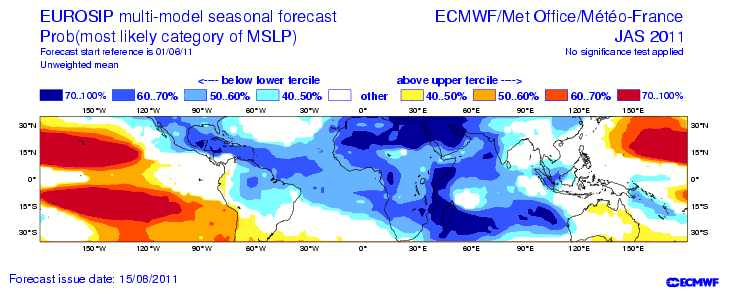
Looking at the Euro seasonal forecast it looks like a active tropical season for July, August, and September.
Hopefully we in Texas will just get some good tropical downpours and nothing more organized than that.
Sea level pressures are forecast to be lower than normal throughout the Caribbean and GOM.
Hopefully we in Texas will just get some good tropical downpours and nothing more organized than that.
Sea level pressures are forecast to be lower than normal throughout the Caribbean and GOM.
0 likes
The following post is NOT an official forecast and should not be used as such. It is just the opinion of the poster and may or may not be backed by sound meteorological data. It is NOT endorsed by any professional institution including storm2k.org For Official Information please refer to the NHC and NWS products.
-
Portastorm
- Storm2k Moderator
- Posts: 9954
- Age: 63
- Joined: Fri Jul 11, 2003 9:16 am
- Location: Round Rock, TX
- Contact:
Re: C/SC TX Weather: Frying Pan Summer
Based on both the GFS and Euro this Sunday morning ... I'd say we have at least a week ahead of no rain and slightly above average high temperatures. No surprise, I guess. 
0 likes
Any forecasts under my name are to be taken with a grain of salt. Get your best forecasts from the National Weather Service and National Hurricane Center.

Re: C/SC TX Weather: Frying Pan Summer
Portastorm wrote:Based on both the GFS and Euro this Sunday morning ... I'd say we have at least a week ahead of no rain and slightly above average high temperatures. No surprise, I guess.
The Cockroach Ridge prevails.
0 likes
-
gboudx

- S2K Supporter
- Posts: 4090
- Joined: Thu Sep 04, 2003 1:39 pm
- Location: Rockwall, Tx but from Harvey, La
Re: C/SC TX Weather: Frying Pan Summer
Portastorm wrote:FWIW, JB is tweeting this morning that the worst of the summer heat for Texas (east of I-35) has probably already occurred and especially so after July 5th.
I hope that verifies and that it means a more active influence from the tropics (i.e. rainfall).
What happens after July 5th?
0 likes
-
Portastorm
- Storm2k Moderator
- Posts: 9954
- Age: 63
- Joined: Fri Jul 11, 2003 9:16 am
- Location: Round Rock, TX
- Contact:
Re: C/SC TX Weather: Frying Pan Summer
gboudx wrote:Portastorm wrote:FWIW, JB is tweeting this morning that the worst of the summer heat for Texas (east of I-35) has probably already occurred and especially so after July 5th.
I hope that verifies and that it means a more active influence from the tropics (i.e. rainfall).
What happens after July 5th?
JB didn't elaborate in the tweet. Others though are suggesting the Cockroach Ridge of Death (i.e. high pressure in summer) will erode some, opening up a tropical influence for us.
I'm thinking our friend Rgv20 is going to enjoy some rain later this week though ... lucky!
0 likes
Any forecasts under my name are to be taken with a grain of salt. Get your best forecasts from the National Weather Service and National Hurricane Center.
-
Rgv20
- S2K Supporter
- Posts: 2466
- Age: 39
- Joined: Wed Jan 05, 2011 5:42 pm
- Location: Edinburg/McAllen Tx
Hopefully we can send you a couple of showers
According to the models we are going to be right on the northern edge of the deep tropical moisture but hopefully that would be enough to get some good rain.
SPECIAL WEATHER STATEMENT
NATIONAL WEATHER SERVICE BROWNSVILLE TX
310 PM CDT MON JUN 27 2011
TXZ248>257-280200-
ZAPATA-JIM HOGG-BROOKS-KENEDY-STARR-HIDALGO-INLAND WILLACY-
INLAND CAMERON-COASTAL WILLACY-COASTAL CAMERON-
INCLUDING THE CITIES OF...ZAPATA...HEBBRONVILLE...FALFURRIAS...
SARITA...RIO GRANDE CITY...ROMA...MCALLEN...EDINBURG...PHARR...
MISSION...WESLACO...RAYMONDVILLE...BROWNSVILLE...HARLINGEN...
PORT MANSFIELD...PORT ISABEL...SOUTH PADRE ISLAND...
LAGUNA HEIGHTS...LAGUNA VISTA
310 PM CDT MON JUN 27 2011
...ADDITIONAL RAINFALL POSSIBLE FOR DEEP SOUTH TEXAS...
DEEP TROPICAL MOISTURE APPROACHING DEEP SOUTH TEXAS FROM A TROPICAL
WAVE NOW LOCATED OVER THE EASTERN BAY OF CAMPECHE WILL INCREASE
THE RAIN CHANCES ACROSS THE REGION STARTING ON WEDNESDAY OF THIS
WEEK. SCATTERED SHOWERS AND THUNDERSTORMS WILL BE POSSIBLE FROM
WEDNESDAY THROUGH FRIDAY AS THIS TROPICAL WAVE MOVES CLOSER TO THE
GULF COAST OF MEXICO. THE RAIN CHANCES WILL THEN START TO DIMINISH
SOMEWHAT LATER THIS UPCOMING WEEKEND AS HIGH PRESSURE ALOFT STARTS
BUILDING BACK IN PLACE OVER THE REGION AND THE REMNANTS OF THIS
TROPICAL WAVE MOVE FURTHER INLAND OVER CENTRAL MEXICO. ALTHOUGH
THE RAIN CHANCES WILL BE DIMINISHING THIS UPCOMING WEEKEND
ISOLATED TO SCATTERED MAINLY AFTERNOON AND EARLY EVENING SHOWERS
AND THUNDERSTORMS WILL BE POSSIBLE THROUGH SUNDAY.
AT THIS TIME THE NATIONAL HURRICANE CENTER GIVES THIS TROPICAL
WAVE A 30 PERCENT CHANCE OF BECOMING A TROPICAL CYCLONE THROUGHOUT
THE NEXT 48 HOURS. THIS TROPICAL WAVE WILL LIKELY BE ONLY A RAIN
MAKER FOR DEEP SOUTH TEXAS WITH OVERALL EXPECTED RAINFALL AMOUNTS
THROUGH FRIDAY NIGHT RANGING FROM A HALF OF AN INCH TO ONE AND A
HALF INCHES. SOME AREAS COULD SEE LOCALLY HEAVIER AMOUNTS. THE
BEST RAIN CHANCES WILL LIKELY BE ALONG AND SOUTH OF THE RIO GRANDE
RIVER THROUGHOUT THIS WEEK. SINCE THE 2011 ATLANTIC HURRICANE
SEASON IS WELL UNDERWAY RESIDENTS OF DEEP SOUTH TEXAS SHOULD
CONTINUE TO MONITOR THE LATEST TROPICAL WEATHER OUTLOOK FROM THE
NATIONAL HURRICANE CENTER FOR THE MOST UP TO DATE TROPICAL
INFORMATION.
ANY RAINFALL PRODUCED BY THIS SYSTEM SHOULD PROVIDE SOME ADDITIONAL
SHORT TERM RELIEF FROM THE CURRENT DROUGHT CONDITIONS AFFECTING
DEEP SOUTH TEXAS. ALTHOUGH NO WIDESPREAD FLOODING PROBLEMS ARE
EXPECTED FOR DEEP SOUTH TEXAS THIS WEEK SOME MINOR FLOODING OF LOW
LYING AREAS AND ROADWAYS WILL BE POSSIBLE.
$$
SPEECE
0 likes
The following post is NOT an official forecast and should not be used as such. It is just the opinion of the poster and may or may not be backed by sound meteorological data. It is NOT endorsed by any professional institution including storm2k.org For Official Information please refer to the NHC and NWS products.
-
Rgv20
- S2K Supporter
- Posts: 2466
- Age: 39
- Joined: Wed Jan 05, 2011 5:42 pm
- Location: Edinburg/McAllen Tx
Damn looking at the 12zECMWF it has the whole Rio Grande Valley in a swath of 3 to 5 inches of rain ending 7am Saturday...Please let it verify!! 
0 likes
The following post is NOT an official forecast and should not be used as such. It is just the opinion of the poster and may or may not be backed by sound meteorological data. It is NOT endorsed by any professional institution including storm2k.org For Official Information please refer to the NHC and NWS products.
-
Rgv20
- S2K Supporter
- Posts: 2466
- Age: 39
- Joined: Wed Jan 05, 2011 5:42 pm
- Location: Edinburg/McAllen Tx
Wow HPC going crazy with the Rain.
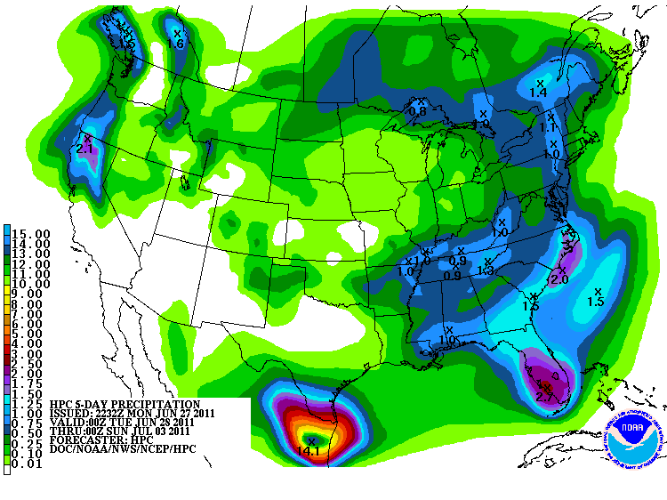
Oh and not to deviate to much from the thread title, It got to 99 at Rio Grande City..Not to bad
Oh and not to deviate to much from the thread title, It got to 99 at Rio Grande City..Not to bad
0 likes
The following post is NOT an official forecast and should not be used as such. It is just the opinion of the poster and may or may not be backed by sound meteorological data. It is NOT endorsed by any professional institution including storm2k.org For Official Information please refer to the NHC and NWS products.
-
Rgv20
- S2K Supporter
- Posts: 2466
- Age: 39
- Joined: Wed Jan 05, 2011 5:42 pm
- Location: Edinburg/McAllen Tx
Looks like TS Arlene will bring some beneficial rainfall to the Rio Grande Valley. 
SPECIAL WEATHER STATEMENT
NATIONAL WEATHER SERVICE BROWNSVILLE TX
842 PM CDT TUE JUN 28 2011
TXZ248>257-291000-
ZAPATA-JIM HOGG-BROOKS-KENEDY-STARR-HIDALGO-INLAND WILLACY-
INLAND CAMERON-COASTAL WILLACY-COASTAL CAMERON-
INCLUDING THE CITIES OF...ZAPATA...HEBBRONVILLE...FALFURRIAS...
SARITA...RIO GRANDE CITY...ROMA...MCALLEN...EDINBURG...PHARR...
MISSION...WESLACO...RAYMONDVILLE...BROWNSVILLE...HARLINGEN...
PORT MANSFIELD...PORT ISABEL...SOUTH PADRE ISLAND...
LAGUNA HEIGHTS...LAGUNA VISTA
842 PM CDT TUE JUN 28 2011
TROPICAL STORM ARLENE FORMS IN THE BAY OF CAMPECHE TO BRING HEAVY
RAIN TO PORTIONS OF RIO GRANDE VALLEY AND DEEP SOUTH TEXAS...
DEEP TROPICAL MOISTURE TO MOVE INTO DEEP SOUTH TEXAS AS TROPICAL
STORM ARLENE MOVES WEST NORTHWEST TOWARD THE CENTRAL MEXICAN
COAST. OCCASIONAL HEAVY RAIN BANDS ARE EXPECTED TO AFFECT THE RIO
GRANDE VALLEY TONIGHT. MORE FREQUENT RAIN BANDS WITH ADDITIONAL
SHOWERS AND ISOLATED THUNDERSTORMS TO FORM ACROSS MOST AREAS OF
DEEP SOUTH TEXAS WEDNESDAY THROUGH THURSDAY AS THE STORM
APPROACHES THE MEXICAN COAST LINE WELL SOUTH OF THE MOUTH OF RIO
GRANDE RIVER. RAIN AMOUNTS THROUGH THURSDAY COULD TOTAL 1 TO 3
WITH AREAS UP TO 5 INCHES. ADDITIONAL SHOWER AND THUNDERSTORMS
CAN BE EXPECTED FRIDAY AND THROUGH THE HOLIDAY WEEKEND ALTHOUGH
THE CHANCES WILL BE DIMINISHING. IN ANY CASE...HEAVY RAIN IS STILL
POSSIBLE WITH ADDITIONAL AMOUNTS OF 1 TO 2 INCHES AND AS MUCH AS 4
INCHES. ALTHOUGH NO WIDESPREAD FLOODING PROBLEMS ARE EXPECTED FOR
DEEP SOUTH TEXAS THIS WEEK SOME MINOR FLOODING OF LOW LYING AREAS
AND ROADWAYS WILL BE POSSIBLE.
WITH THE STORM TO REMAIN WELL SOUTH OF THE AREA WINDS ARE NOT
EXPECTED TO BEAR ANY IMPACT. TROPICAL EAST BREEZES OF 15 TO 20 MPH
WITH SOME GUSTS TO 25 MPH ARE LIKELY WEDNESDAY AND THURSDAY.
MARINE AND BEACH WEATHER WILL GRADUALLY DETERIORATE OVER THE NEXT
FEW DAYS. SMALL CRAFT ADVISORIES ARE IN EFFECT FOR OFFSHORE
COASTAL WATERS TONIGHT AND WILL LIKELY BE EXTENDED THROUGH
THURSDAY. WINDS OFFSHORE TO RANGE FROM 20 TO 25 KNOTS WITH HIGHER
GUSTS IN NUMEROUS SHOWERS AND THUNDERSTORMS. SWELLS TO INCREASE
ABOVE 8 FEET WEDNESDAY WITH THE SWELL PERIOD NEARING 10 SECONDS.
MARINERS ARE URGED TO REMAIN IN PORT UNTIL TROPICAL STORM ARLENE
MOVES INLAND SOME TIME THURSDAY. ALONG THE BEACHES RIP CURRENT
RISK HAS BEEN ELEVATED TO HIGH AND WILL REMAIN HIGH POSSIBLY
THROUGH THE HOLIDAY WEEKEND. A COASTAL FLOOD ADVISORY AND A HIGH
SURF ADVISORY MAY BE NEEDED WEDNESDAY AND THURSDAY DEPENDING ON
HOW MUCH ARLENE STRENGTHENS.
$$
0 likes
The following post is NOT an official forecast and should not be used as such. It is just the opinion of the poster and may or may not be backed by sound meteorological data. It is NOT endorsed by any professional institution including storm2k.org For Official Information please refer to the NHC and NWS products.
-
Rgv20
- S2K Supporter
- Posts: 2466
- Age: 39
- Joined: Wed Jan 05, 2011 5:42 pm
- Location: Edinburg/McAllen Tx
0zGFS with very heavy rain total just south of the Border.
This are the totals thru Friday 7pm (72hrs).
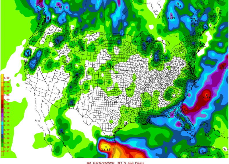
This are the totals thru Friday 7pm (72hrs).
0 likes
The following post is NOT an official forecast and should not be used as such. It is just the opinion of the poster and may or may not be backed by sound meteorological data. It is NOT endorsed by any professional institution including storm2k.org For Official Information please refer to the NHC and NWS products.
-
Rgv20
- S2K Supporter
- Posts: 2466
- Age: 39
- Joined: Wed Jan 05, 2011 5:42 pm
- Location: Edinburg/McAllen Tx
Arlene sending some Rain to the Valley
SPECIAL WEATHER STATEMENT
NATIONAL WEATHER SERVICE BROWNSVILLE TX
642 AM CDT THU JUN 30 2011
TXZ253>257-301400-
HIDALGO-INLAND WILLACY-INLAND CAMERON-COASTAL WILLACY-
COASTAL CAMERON-
INCLUDING THE CITIES OF...MCALLEN...EDINBURG...PHARR...MISSION...
WESLACO...RAYMONDVILLE...BROWNSVILLE...HARLINGEN...
PORT MANSFIELD...PORT ISABEL...SOUTH PADRE ISLAND...
LAGUNA HEIGHTS...LAGUNA VISTA
642 AM CDT THU JUN 30 2011
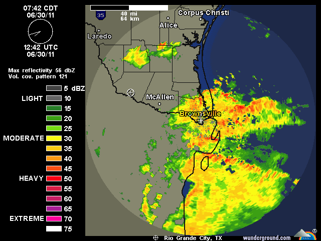
...HEAVY RAIN BANDS FROM ARLENE MOVING INTO THE LOWER RIO GRANDE
VALLEY...
AT 635 AM...NATIONAL WEATHER SERVICE DOPPLER RADAR IN BROWNSVILLE
INDICATED THAT A MODERATE TO HEAVY RAIN BAND ASSOCIATED WITH THE
NORTHERN EDGE OF TROPICAL STORM ARLENE IS MOVING INTO THE SOUTHERN
AND EASTERN PORTIONS OF CAMERON COUNTY. THIS RAIN BAND IS MOVING
TO THE WEST NORTHWEST AT AROUND 25 TO 30 MPH AND IS PRODUCING
RAINFALL RATES FROM ONE TO ONE AND A HALF INCHES AN HOUR.
THESE AREAS OF TROPICAL RAINFALL WILL LIKELY MOVE INTO HIDALGO AND
WILLACY COUNTIES OVER THE NEXT ONE TO TWO HOURS PRODUCING SOME
LOCALLY HEAVY RAINS.
THESE MODERATE TO HEAVY RAINS WILL CAUSE MINOR FLOODING OR PONDING
OF WATER IN LOW LYING AREAS AND ROADWAYS. EARLY MORNING MOTORISTS
SHOULD SLOW DOWN AND MAINTAIN A SAFE FOLLOWING DISTANCE BETWEEN
VEHICLES THROUGH MID MORNING.
$$
SPEECE
SPECIAL WEATHER STATEMENT
NATIONAL WEATHER SERVICE BROWNSVILLE TX
642 AM CDT THU JUN 30 2011
TXZ253>257-301400-
HIDALGO-INLAND WILLACY-INLAND CAMERON-COASTAL WILLACY-
COASTAL CAMERON-
INCLUDING THE CITIES OF...MCALLEN...EDINBURG...PHARR...MISSION...
WESLACO...RAYMONDVILLE...BROWNSVILLE...HARLINGEN...
PORT MANSFIELD...PORT ISABEL...SOUTH PADRE ISLAND...
LAGUNA HEIGHTS...LAGUNA VISTA
642 AM CDT THU JUN 30 2011
...HEAVY RAIN BANDS FROM ARLENE MOVING INTO THE LOWER RIO GRANDE
VALLEY...
AT 635 AM...NATIONAL WEATHER SERVICE DOPPLER RADAR IN BROWNSVILLE
INDICATED THAT A MODERATE TO HEAVY RAIN BAND ASSOCIATED WITH THE
NORTHERN EDGE OF TROPICAL STORM ARLENE IS MOVING INTO THE SOUTHERN
AND EASTERN PORTIONS OF CAMERON COUNTY. THIS RAIN BAND IS MOVING
TO THE WEST NORTHWEST AT AROUND 25 TO 30 MPH AND IS PRODUCING
RAINFALL RATES FROM ONE TO ONE AND A HALF INCHES AN HOUR.
THESE AREAS OF TROPICAL RAINFALL WILL LIKELY MOVE INTO HIDALGO AND
WILLACY COUNTIES OVER THE NEXT ONE TO TWO HOURS PRODUCING SOME
LOCALLY HEAVY RAINS.
THESE MODERATE TO HEAVY RAINS WILL CAUSE MINOR FLOODING OR PONDING
OF WATER IN LOW LYING AREAS AND ROADWAYS. EARLY MORNING MOTORISTS
SHOULD SLOW DOWN AND MAINTAIN A SAFE FOLLOWING DISTANCE BETWEEN
VEHICLES THROUGH MID MORNING.
$$
SPEECE
0 likes
The following post is NOT an official forecast and should not be used as such. It is just the opinion of the poster and may or may not be backed by sound meteorological data. It is NOT endorsed by any professional institution including storm2k.org For Official Information please refer to the NHC and NWS products.
-
Portastorm
- Storm2k Moderator
- Posts: 9954
- Age: 63
- Joined: Fri Jul 11, 2003 9:16 am
- Location: Round Rock, TX
- Contact:
Re: C/SC TX Weather: Frying Pan Summer
We're jealous Rgv20, ok?! 
Enjoy Arlene's rain and may it soak the Valley!
Enjoy Arlene's rain and may it soak the Valley!
0 likes
Any forecasts under my name are to be taken with a grain of salt. Get your best forecasts from the National Weather Service and National Hurricane Center.
-
Rgv20
- S2K Supporter
- Posts: 2466
- Age: 39
- Joined: Wed Jan 05, 2011 5:42 pm
- Location: Edinburg/McAllen Tx
Re: C/SC TX Weather: Frying Pan Summer
Portastorm wrote:We're jealous Rgv20, ok?!
Enjoy Arlene's rain and may it soak the Valley!
The Brownsville area was the big winner today, it Rain anywhere from 3 to 5 inches.
At my house I only received 0.74 inches, with more rain in the forecast for tomorrow.
Oh, and Arlene brought a friend with her to the Valley....


This was near Hidalgo, Texas
0 likes
The following post is NOT an official forecast and should not be used as such. It is just the opinion of the poster and may or may not be backed by sound meteorological data. It is NOT endorsed by any professional institution including storm2k.org For Official Information please refer to the NHC and NWS products.
Return to “USA & Caribbean Weather”
Who is online
Users browsing this forum: No registered users and 36 guests