

For those of you that remember Derek Ortt...you can check him out with impact weather video updates.
http://www.youtube.com/user/impactweath ... DFhXgkUjcc
ATL: ARLENE - Remnants
Moderator: S2k Moderators
-
JtSmarts

- S2K Supporter

- Posts: 1442
- Age: 40
- Joined: Thu Jul 10, 2003 1:29 pm
- Location: Columbia, South Carolina
Re: ATL: ARLENE - Tropical Storm - Discussion
Ivanhater wrote:For those of you that remember Derek Ortt...you can check him out with impact weather video updates.
http://www.youtube.com/user/impactweath ... DFhXgkUjcc
Wow thanks for posting that. I love our meteorologists that are here but I definitely do miss having Derek around.
0 likes
-
South Texas Storms

- Professional-Met

- Posts: 4256
- Joined: Thu Jun 24, 2010 12:28 am
- Location: Houston, TX
Re: ATL: ARLENE - Tropical Storm - Discussion
Hey Rgv how much rain have you gotten so far from Arlene?
0 likes
-
Hylian Auree

- Tropical Storm

- Posts: 150
- Age: 33
- Joined: Thu Dec 02, 2010 7:01 pm
- Location: Willemstad, Curaçao
- Contact:
-
South Texas Storms
- Professional-Met
- Posts: 4256
- Joined: Thu Jun 24, 2010 12:28 am
- Location: Houston, TX
Re:
Hurricane wrote:Brownsville got some beneficial rain from this!
Hurricane you are a professional met? And where are you from in Texas?
0 likes
-
cycloneye

- Admin

- Posts: 149364
- Age: 69
- Joined: Thu Oct 10, 2002 10:54 am
- Location: San Juan, Puerto Rico
Re: ATL: ARLENE - Advisories
BULLETIN
TROPICAL DEPRESSION ARLENE INTERMEDIATE ADVISORY NUMBER 9A
NWS NATIONAL HURRICANE CENTER MIAMI FL AL012011
700 PM CDT THU JUN 30 2011
...ARLENE WEAKENS TO A TROPICAL DEPRESSION...HEAVY RAINFALL
CONTINUES OVER MUCH OF EASTERN MEXICO...
SUMMARY OF 700 PM CDT...0000 UTC...INFORMATION
----------------------------------------------
LOCATION...21.1N 98.7W
ABOUT 85 MI...135 KM W OF TUXPAN MEXICO
ABOUT 90 MI...145 KM SW OF TAMPICO MEXICO
MAXIMUM SUSTAINED WINDS...35 MPH...55 KM/H
PRESENT MOVEMENT...WSW OR 255 DEGREES AT 7 MPH...11 KM/H
MINIMUM CENTRAL PRESSURE...1002 MB...29.59 INCHES
WATCHES AND WARNINGS
--------------------
CHANGES WITH THIS ADVISORY...
THE GOVERNMENT OF MEXICO HAS DISCONTINUED ALL WARNINGS FOR THE COAST
OF MEXICO.
SUMMARY OF WATCHES AND WARNINGS IN EFFECT...
NONE.
FOR INFORMATION SPECIFIC TO YOUR AREA...PLEASE MONITOR PRODUCTS
ISSUED BY YOUR NATIONAL METEOROLOGICAL SERVICE.
DISCUSSION AND 48-HOUR OUTLOOK
------------------------------
AT 700 PM CDT...0000 UTC...THE CENTER OF TROPICAL DEPRESSION ARLENE
WAS LOCATED NEAR LATITUDE 21.1 NORTH...LONGITUDE 98.7 WEST. ARLENE
IS MOVING TOWARD THE WEST-SOUTHWEST NEAR 7 MPH...11 KM/H...AND THIS
GENERAL MOTION SHOULD CONTINUE UNTIL DISSIPATION. ON THE FORECAST
TRACK...THE CENTER OF ARLENE WILL MOVE FARTHER INLAND AND OVER
HIGHER TERRAIN TONIGHT.
MAXIMUM SUSTAINED WINDS HAVE DECREASED TO NEAR 35 MPH...
55 KM/H...WITH HIGHER GUSTS. CONTINUED WEAKENING IS FORECAST...AND
ARLENE WILL LIKELY DISSIPATE OVER THE MOUNTAINS OF EASTERN MEXICO
LATER TONIGHT OR EARLY FRIDAY.
ESTIMATED MINIMUM CENTRAL PRESSURE IS 1002 MB...29.59 INCHES.
HAZARDS AFFECTING LAND
----------------------
RAINFALL...ARLENE IS EXPECTED TO PRODUCE TOTAL RAINFALL
ACCUMULATIONS OF 4 TO 8 INCHES OVER EASTERN AND NORTHEASTERN
MEXICO...WITH POSSIBLE ISOLATED MAXIMUM AMOUNTS OF 15 INCHES OVER
MOUNTAINOUS TERRAIN. THESE RAINS COULD CAUSE LIFE-THREATENING
FLASH FLOODS AND MUD SLIDES.
NEXT ADVISORY
-------------
NEXT COMPLETE ADVISORY...1000 PM CDT.
$$
FORECASTER CANGIALOSI/BROWN
0 likes
Visit the Caribbean-Central America Weather Thread where you can find at first post web cams,radars
and observations from Caribbean basin members Click Here
and observations from Caribbean basin members Click Here
-
cycloneye
- Admin
- Posts: 149364
- Age: 69
- Joined: Thu Oct 10, 2002 10:54 am
- Location: San Juan, Puerto Rico
Re: ATL: ARLENE - Advisories
REMNANTS OF ARLENE DISCUSSION NUMBER 10
NWS NATIONAL HURRICANE CENTER MIAMI FL AL012011
1000 PM CDT THU JUN 30 2011
SATELLITE IMAGES AND SURFACE OBSERVATIONS INDICATE THAT THE
LOW-LEVEL CIRCULATION OF ARLENE HAS DISSIPATED OVER THE HIGH AND
RUGGED TERRAIN OF THE SIERRA MADRE MOUNTAINS. THEREFORE...ARLENE
IS NO LONGER A TROPICAL CYCLONE AND THIS IS THE LAST ADVISORY ON
THIS SYSTEM.
HEAVY RAINFALL ASSOCIATED WITH THE REMNANTS OF ARLENE WILL LIKELY
CONTINUE OVER MUCH OF EASTERN AND CENTRAL MEXICO DURING THE NEXT
DAY OR SO. THESE RAINS COULD PRODUCE FLASH FLOODS AND MUDSLIDES...
ESPECIALLY IN AND NEAR AREAS OF HIGH TERRAIN.
FORECAST POSITIONS AND MAX WINDS
INIT 01/0300Z 20.9N 99.1W 25 KT 30 MPH
12H 01/1200Z...DISSIPATED
$$
FORECASTER CANGIALOSI/BROWN
0 likes
Visit the Caribbean-Central America Weather Thread where you can find at first post web cams,radars
and observations from Caribbean basin members Click Here
and observations from Caribbean basin members Click Here
-
Rgv20

- S2K Supporter
- Posts: 2466
- Age: 39
- Joined: Wed Jan 05, 2011 5:42 pm
- Location: Edinburg/McAllen Tx
Re: ATL: ARLENE - Tropical Storm - Discussion
South Texas Storms wrote:Hey Rgv how much rain have you gotten so far from Arlene?
So far 0.74 in. at my house. Hopefully we should get more rain tomorrow.
0 likes
The following post is NOT an official forecast and should not be used as such. It is just the opinion of the poster and may or may not be backed by sound meteorological data. It is NOT endorsed by any professional institution including storm2k.org For Official Information please refer to the NHC and NWS products.
-
Rgv20
- S2K Supporter
- Posts: 2466
- Age: 39
- Joined: Wed Jan 05, 2011 5:42 pm
- Location: Edinburg/McAllen Tx
Oh, and Arlene brought a friend with her to the Valley....
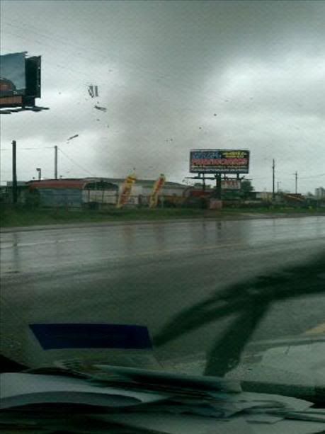
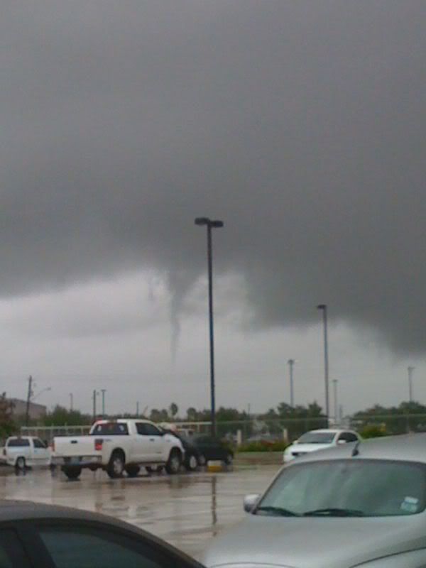
This was near Hidalgo, Texas
This was near Hidalgo, Texas
0 likes
The following post is NOT an official forecast and should not be used as such. It is just the opinion of the poster and may or may not be backed by sound meteorological data. It is NOT endorsed by any professional institution including storm2k.org For Official Information please refer to the NHC and NWS products.


-
South Texas Storms
- Professional-Met
- Posts: 4256
- Joined: Thu Jun 24, 2010 12:28 am
- Location: Houston, TX
Re: ATL: ARLENE - Remnants
Dang Rgv I heard about that in the SA news. Did you take that picture and was it near you?
0 likes
-
Rgv20
- S2K Supporter
- Posts: 2466
- Age: 39
- Joined: Wed Jan 05, 2011 5:42 pm
- Location: Edinburg/McAllen Tx
It was about 45 miles east of where I live.
0 likes
The following post is NOT an official forecast and should not be used as such. It is just the opinion of the poster and may or may not be backed by sound meteorological data. It is NOT endorsed by any professional institution including storm2k.org For Official Information please refer to the NHC and NWS products.
Re:
Hylian Auree wrote:There are people killed in Mexico, ya know, where the storm actually made landfall, and all I see is discussion about rainfall in Texas. I'm really happy for you guys, because the drought has been terrible, but I'm a bit disappointed to see such a one-sided discussion.
Actually it's been as dry in much of Mexico as it has in Texas (and at least Arlene is getting talked about, which is more than I can say about their drought)
0 likes

Re: ATL: ARLENE - Remnants
i live in brownsville, TX and some parts of the city got over 5 inches while others got 3 or 2....there was minor flooding as well...hopefully the people in mexico will get through all the rain
0 likes


Re:
Hylian Auree wrote:There are people killed in Mexico, ya know, where the storm actually made landfall, and all I see is discussion about rainfall in Texas. I'm really happy for you guys, because the drought has been terrible, but I'm a bit disappointed to see such a one-sided discussion.
Hylian, I am so sorry to hear that. Do you have any links to the reports of what has happened there? I have not seen or heard anything on this. I promise you, if we had, there would be discussion of it. My thoughts and prayers are with all there.
0 likes


Re: ATL: ARLENE - Remnants
I have this link but it was in Spanish so I used Microsoft translator, obviously is not a perfect translation but it's understandable, an excerpt:
Three dead, about a thousand people displaced from their homes, cut off communities, swollen streams, drop cables and trees, cuts electricity and landslides, are the first effects of tropical storm Arlene in Veracruz, San Luis Potosí, Hidalgo, Puebla, Oaxaca, Guerrero and Tamaulipas.
The link: http://www.microsofttranslator.com/bv.aspx?from=&to=en&a=http%3A%2F%2Fwww.eluniversal.com.mx%2Festados%2F81005.html
0 likes
-
Blown Away

- S2K Supporter
- Posts: 10253
- Joined: Wed May 26, 2004 6:17 am
Re: ATL: ARLENE - Tropical Storm - Discussion
Ivanhater wrote:For those of you that remember Derek Ortt...you can check him out with impact weather video updates.
http://www.youtube.com/user/impactweath ... DFhXgkUjcc
Cool, I do miss his weather expertise and his temper, he was kinda funny when he would get frustrated with people's posts. He needs a makeover and needs to loosen up a bit, great information, but a little robotic in the delivery.
0 likes
Hurricane Eye Experience: David 79, Irene 99, Frances 04, Jeanne 04, Wilma 05… Hurricane Brush Experience: Andrew 92, Erin 95, Floyd 99, Matthew 16, Irma 17, Ian 22, Nicole 22…
Re: ATL: ARLENE - Remnants
Macrocane wrote:I have this link but it was in Spanish so I used Microsoft translator, obviously is not a perfect translation but it's understandable, an excerpt:
Three dead, about a thousand people displaced from their homes, cut off communities, swollen streams, drop cables and trees, cuts electricity and landslides, are the first effects of tropical storm Arlene in Veracruz, San Luis Potosí, Hidalgo, Puebla, Oaxaca, Guerrero and Tamaulipas.
The link: http://www.microsofttranslator.com/bv.aspx?from=&to=en&a=http%3A%2F%2Fwww.eluniversal.com.mx%2Festados%2F81005.html
wow! Macrocane! Thanks for the link, and the translation. I am so sorry to hear this. It's amazing what even a tropical storm can do. My thoughts and prayers are with all affected by Arlene.
0 likes
-
brunota2003

- S2K Supporter
- Posts: 9476
- Age: 35
- Joined: Sat Jul 30, 2005 9:56 pm
- Location: Stanton, KY...formerly Havelock, NC
- Contact:
Re: ATL: ARLENE - Tropical Storm - Discussion
brunota2003 wrote:CIMSS finally updated...I believe Arlene will make a run at RI. Don't have any time to stare and write things out, believe the run will start in about 4 to 6 hours. Land and time are major downers to a run at RI, but I think she'll try to reach 70 or 75 knots before landfall.
The next recon flight makes their first fix at 5 pm EDT, roughly...right about the time things might really kick off. Let's hope I'm wrong!Personal Forecast Disclaimer:
The posts in this forum are NOT official forecast and should not be used as such. They are just the opinion of the poster and may or may not be backed by sound meteorological data. They are NOT endorsed by any professional institution or storm2k.org. For official information, please refer to the NHC and NWS products.
Well, THAT was a bust
0 likes
Who is online
Users browsing this forum: No registered users and 22 guests