
That blob is almost directly over this buoy...winds were brisk and have just started to fall pretty quickly
http://www.ndbc.noaa.gov/station_page.php?station=42059
Tis usually means one of two things:
1. Here comes an outflow boundary
2. LLC is forming and backing the winds (pressure should be falling though)
Likely the first option...
Disturbed Weather in Carribbean
Moderator: S2k Moderators
Forum rules

The posts in this forum are NOT official forecasts and should not be used as such. They are just the opinion of the poster and may or may not be backed by sound meteorological data. They are NOT endorsed by any professional institution or STORM2K. For official information, please refer to products from the National Hurricane Center and National Weather Service.
-
cycloneye

- Admin

- Posts: 149514
- Age: 69
- Joined: Thu Oct 10, 2002 10:54 am
- Location: San Juan, Puerto Rico
Re: Disturbing Weather in Carribbean
TROPICAL WEATHER OUTLOOK
NWS NATIONAL HURRICANE CENTER MIAMI FL
800 AM EDT SAT JUL 2 2011
FOR THE NORTH ATLANTIC...CARIBBEAN SEA AND THE GULF OF MEXICO...
SHOWERS AND THUNDERSTORMS OVER THE LEEWARD ISLANDS...VIRGIN
ISLANDS...PUERTO RICO...THE DOMINICAN REPUBLIC...AND THE ADJACENT
WATERS OF THE CARIBBEAN AND THE ATLANTIC ARE ASSOCIATED WITH A
TROPICAL WAVE INTERACTING WITH AN UPPER-LEVEL TROUGH. UPPER-LEVEL
WINDS ARE NOT FAVORABLE FOR DEVELOPMENT...AND THERE IS A LOW
CHANCE...NEAR 0 PERCENT...OF THIS SYSTEM BECOMING A TROPICAL
CYCLONE DURING THE NEXT 48 HOURS. REGARDLESS OF DEVELOPMENT...
LOCALLY HEAVY RAINS AND GUSTY WINDS ARE EXPECTED TO SPREAD WESTWARD
ACROSS THE CENTRAL CARIBBEAN SEA...HAITI...AND EASTERN CUBA DURING
THE NEXT DAY OR TWO.
ELSEWHERE...TROPICAL CYCLONE FORMATION IS NOT EXPECTED DURING THE
NEXT 48 HOURS.
$$
FORECASTER BEVEN
0 likes
Visit the Caribbean-Central America Weather Thread where you can find at first post web cams,radars
and observations from Caribbean basin members Click Here
and observations from Caribbean basin members Click Here

Re: Disturbing Weather in Carribbean
This T-wave is slowly picking up model support when it reaches near 80W. Both the 00Z CMC and Euro develop this wave with the CMC off S FL amd moving up the state and Euro off the western tip of Cuba and moving up toward the FL panhandle. NOGAPs splits the vorticity with one piece off the FL east coast and another in the EGOM. None of the models are very strong.
http://moe.met.fsu.edu/cgi-bin/cmctc2.cgi?time=2011070200&field=Sea+Level+Pressure&hour=Animation
http://raleighwx.americanwx.com/models/euro/00zeurotropical850mbVortSLP168.gif
http://moe.met.fsu.edu/cgi-bin/cmctc2.cgi?time=2011070200&field=Sea+Level+Pressure&hour=Animation
http://raleighwx.americanwx.com/models/euro/00zeurotropical850mbVortSLP168.gif
0 likes
-
srainhoutx

- S2K Supporter

- Posts: 6919
- Age: 68
- Joined: Sun Jan 14, 2007 11:34 am
- Location: Haywood County, NC
- Contact:
Re: Disturbing Weather in Carribbean
The Euro ensembles suggest the SW Caribbean is the location to watch in the days ahead. 
0 likes
Carla/Alicia/Jerry(In The Eye)/Michelle/Charley/Ivan/Dennis/Katrina/Rita/Wilma/Ike/Harvey
Member: National Weather Association
Wx Infinity Forums
http://wxinfinity.com/index.php
Facebook.com/WeatherInfinity
Twitter @WeatherInfinity
Member: National Weather Association
Wx Infinity Forums
http://wxinfinity.com/index.php
Facebook.com/WeatherInfinity
Twitter @WeatherInfinity

Re: Disturbing Weather in Carribbean
drezee wrote:That blob is almost directly over this buoy...winds were brisk and have just started to fall pretty quickly
http://www.ndbc.noaa.gov/station_page.php?station=42059
Tis usually means one of two things:
1. Here comes an outflow boundary
2. LLC is forming and backing the winds (pressure should be falling though)
Likely the first option...
Yeah I noticed on the CIMSS site last nite that the 850 mb voricity was almost nonexistent while at the 750 and 500 level was very near where the shower acticivity is occurring, strong easterly winds at surface.
http://tropic.ssec.wisc.edu/real-time/w ... oom=&time=
0 likes
The following post is NOT an official forecast and should not be used as such. It is just the opinion of the poster and may or may not be backed by sound meteorological data. It is NOT endorsed by any professional institution including storm2k.org For Official Information please refer to the NHC and NWS products.

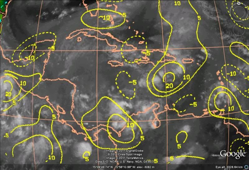
There's nothing happening south of P.R., pressures are high and keep going up.
In two to three days is when the tropical wave might look more interesting when it gets into the central & western Caribbean, when at least a broad area of low pressure might form.
If it gets enough breathing space from the ULL ahead of it, it might do something, but very slowly.
In two to three days is when the tropical wave might look more interesting when it gets into the central & western Caribbean, when at least a broad area of low pressure might form.
If it gets enough breathing space from the ULL ahead of it, it might do something, but very slowly.
0 likes
-
gatorcane

- S2K Supporter
- Posts: 23708
- Age: 48
- Joined: Sun Mar 13, 2005 3:54 pm
- Location: Boca Raton, FL
ZCZC MIATWOAT ALL
TTAA00 KNHC DDHHMM
TROPICAL WEATHER OUTLOOK
NWS NATIONAL HURRICANE CENTER MIAMI FL
200 PM EDT SAT JUL 2 2011
FOR THE NORTH ATLANTIC...CARIBBEAN SEA AND THE GULF OF MEXICO...
1. SHOWERS AND THUNDERSTORMS OVER THE LEEWARD ISLANDS...VIRGIN
ISLANDS...PUERTO RICO...THE DOMINICAN REPUBLIC...AND THE ADJACENT
WATERS OF THE CARIBBEAN AND THE ATLANTIC ARE ASSOCIATED WITH A
TROPICAL WAVE INTERACTING WITH AN UPPER-LEVEL TROUGH. UPPER-LEVEL
WINDS ARE NOT FAVORABLE FOR DEVELOPMENT...AND THERE IS A LOW
CHANCE...NEAR 0 PERCENT...OF THIS SYSTEM BECOMING A TROPICAL
CYCLONE DURING THE NEXT 48 HOURS. REGARDLESS OF DEVELOPMENT...
LOCALLY HEAVY RAINS AND GUSTY WINDS ARE EXPECTED TO SPREAD WESTWARD
TO WEST-NORTHWESTWARD ACROSS HAITI... EASTERN CUBA...THE
SOUTHEASTERN BAHAMAS...AND THE ADJACENT WATERS DURING THE NEXT DAY
OR TWO.
ELSEWHERE...TROPICAL CYCLONE FORMATION IS NOT EXPECTED DURING THE
NEXT 48 HOURS.
$$
FORECASTER BEVEN
NNNN
http://www.nhc.noaa.gov/gtwo_atl.shtml
0 likes
-
srainhoutx
- S2K Supporter
- Posts: 6919
- Age: 68
- Joined: Sun Jan 14, 2007 11:34 am
- Location: Haywood County, NC
- Contact:
Re: Disturbing Weather in Carribbean
HPC Update:
IN REGARDS TO TROPICAL WEATHER...ENOUGH 00Z GLOBAL ENSEMBLE
MEMBERS WERE SPLAYED OUT ALONG AN ELONGATED AXIS ACROSS/AROUND THE
FLORIDA PENINSULA NEXT WEEKEND TO DEPICT A RETROGRADING INVERTED
TROUGH ACROSS THE SUNSHINE STATE/EASTERN GULF OF MEXICO/WESTERN
SUBTROPICAL ATLANTIC LATE IN THE PERIOD. THIS FEATURE IS THE
NORTHERN PORTION OF A TROPICAL WAVE CURRENTLY LOCATED NORTH OF
PUERTO RICO WHICH IS EXPECTED TO MOVE INTO A MORE FAVORABLE UPPER
LEVEL ENVIRONMENT DURING THE MEDIUM RANGE PERIOD AS IT APPROACHES
THE FLORIDA PENINSULA.
0 likes
Carla/Alicia/Jerry(In The Eye)/Michelle/Charley/Ivan/Dennis/Katrina/Rita/Wilma/Ike/Harvey
Member: National Weather Association
Wx Infinity Forums
http://wxinfinity.com/index.php
Facebook.com/WeatherInfinity
Twitter @WeatherInfinity
Member: National Weather Association
Wx Infinity Forums
http://wxinfinity.com/index.php
Facebook.com/WeatherInfinity
Twitter @WeatherInfinity
-
Ivanhater

- Storm2k Moderator

- Posts: 11221
- Age: 39
- Joined: Fri Jul 01, 2005 8:25 am
- Location: Pensacola
Re: Disturbing Weather in Carribbean
I don't like what the models are showing right now. The Euro suggests this coming in around the Florida panhandle next weekend. There is a huge air show with the Blue angels flying on Pensacola beach. I will not be a happy camper 
My eye will be on this one
My eye will be on this one
0 likes
Michael
-
midnight8

- Tropical Depression

- Posts: 75
- Age: 52
- Joined: Sat Aug 14, 2010 3:05 pm
- Location: Orange, Texas
Re: Disturbing Weather in Carribbean
Ivanhater wrote:I don't like what the models are showing right now. The Euro suggests this coming in around the Florida panhandle next weekend. There is a huge air show with the Blue angels flying on Pensacola beach. I will not be a happy camper
My eye will be on this one
Love the Blue Angels. No one should have to miss that. so we will gladly take it over here.
Last edited by midnight8 on Sat Jul 02, 2011 3:51 pm, edited 1 time in total.
0 likes
KF5KWF Orange, Texas
-
Portastorm

- Storm2k Moderator
- Posts: 9955
- Age: 63
- Joined: Fri Jul 11, 2003 9:16 am
- Location: Round Rock, TX
- Contact:
Re: Disturbing Weather in Carribbean
midnight8 wrote:Ivanhater wrote:I don't like what the models are showing right now. The Euro suggests this coming in around the Florida panhandle next weekend. There is a huge air show with the Blue angels flying on Pensacola beach. I will not be a happy camper
My eye will be on this one
Love the Blue Angels. No one should have to miss that. o we will gladly take it over here.
Yeah I was just going to say ... feel free to blow it this way!
0 likes
Any forecasts under my name are to be taken with a grain of salt. Get your best forecasts from the National Weather Service and National Hurricane Center.
-
HurricaneBrain

- S2K Supporter
- Posts: 520
- Joined: Thu Jun 30, 2011 2:07 pm
-
Florida1118
Re: Disturbing Weather in Carribbean
Are the NHC expecting this to form later if their mentioning it at 0% in the next 48, but perhaps later on development? Im still not getting why mention it if it wont develop, unless it could later down the road
0 likes
-
USTropics
- Professional-Met

- Posts: 2739
- Joined: Sun Aug 12, 2007 3:45 am
- Location: Florida State University
Re: Disturbing Weather in Carribbean
Florida1118 wrote:Are the NHC expecting this to form later if their mentioning it at 0% in the next 48, but perhaps later on development? Im still not getting why mention it if it wont develop, unless it could later down the road
That appears to be the exact reason why they are mentioning it right now. It's true that in the next 48 hours, environmental conditions are not conducive for development, but as the shear begins to decrease three days from now it will be in a more favorable environment. Not sure how conducive an environment it will be in, but something to watch for now and in the coming week. At the very least those of us in Florida could see some rain. The HPC also alludes to this:
THIS FEATURE IS THE NORTHERN PORTION OF A TROPICAL WAVE CURRENTLY LOCATED NORTH OF
PUERTO RICO WHICH IS EXPECTED TO MOVE INTO A MORE FAVORABLE UPPER
LEVEL ENVIRONMENT DURING THE MEDIUM RANGE PERIOD AS IT APPROACHES
THE FLORIDA PENINSULA.
Last edited by USTropics on Sat Jul 02, 2011 4:13 pm, edited 1 time in total.
0 likes
-
HurricaneBrain
- S2K Supporter
- Posts: 520
- Joined: Thu Jun 30, 2011 2:07 pm
Re: Disturbing Weather in Carribbean
Florida1118 wrote:Are the NHC expecting this to form later if their mentioning it at 0% in the next 48, but perhaps later on development? Im still not getting why mention it if it wont develop, unless it could later down the road
The NHC gives it a near 0% chance of forming in the next 48 hours. That could be a 1%, 2%, etc. The NHC definitely sees something down the road if they are already giving it some kind of chance to develop. It took Arlene almost a whole week to get a 10% chance. Just wait until this gets into better conditions and we might have our hands on another storm.
0 likes
-
Florida1118
Re: Disturbing Weather in Carribbean
Ive never seen them release a TWO this early...they released it a 6:38 EDT. And they dont mention it anymore...Im assuming well see it later in the week
000
ABNT20 KNHC 022238
TWOAT
TROPICAL WEATHER OUTLOOK
NWS NATIONAL HURRICANE CENTER MIAMI FL
800 PM EDT SAT JUL 2 2011
FOR THE NORTH ATLANTIC...CARIBBEAN SEA AND THE GULF OF MEXICO...
TROPICAL CYCLONE FORMATION IS NOT EXPECTED DURING THE NEXT 48 HOURS.
$$
FORECASTER CANGIALOSI
000
ABNT20 KNHC 022238
TWOAT
TROPICAL WEATHER OUTLOOK
NWS NATIONAL HURRICANE CENTER MIAMI FL
800 PM EDT SAT JUL 2 2011
FOR THE NORTH ATLANTIC...CARIBBEAN SEA AND THE GULF OF MEXICO...
TROPICAL CYCLONE FORMATION IS NOT EXPECTED DURING THE NEXT 48 HOURS.
$$
FORECASTER CANGIALOSI
0 likes
-
JonathanBelles
- Professional-Met
- Posts: 11430
- Age: 35
- Joined: Sat Dec 24, 2005 9:00 pm
- Location: School: Florida State University (Tallahassee, FL) Home: St. Petersburg, Florida
- Contact:
Re: Disturbing Weather in Carribbean
Florida1118 wrote:Ive never seen them release a TWO this early...they released it a 6:38 EDT. And they dont mention it anymore...Im assuming well see it later in the week
Wow! I thought that one last week was early before Arlene. That was at around 7p.
0 likes
-
HurricaneBrain
- S2K Supporter
- Posts: 520
- Joined: Thu Jun 30, 2011 2:07 pm
-
floridasun78
- Category 5

- Posts: 3755
- Joined: Sun May 17, 2009 10:16 pm
- Location: miami fl
Re: Disturbing Weather in Carribbean
so area east florida models have system forming or one in carribbean?
0 likes
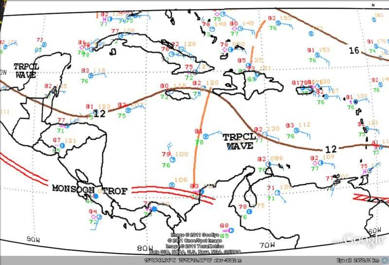
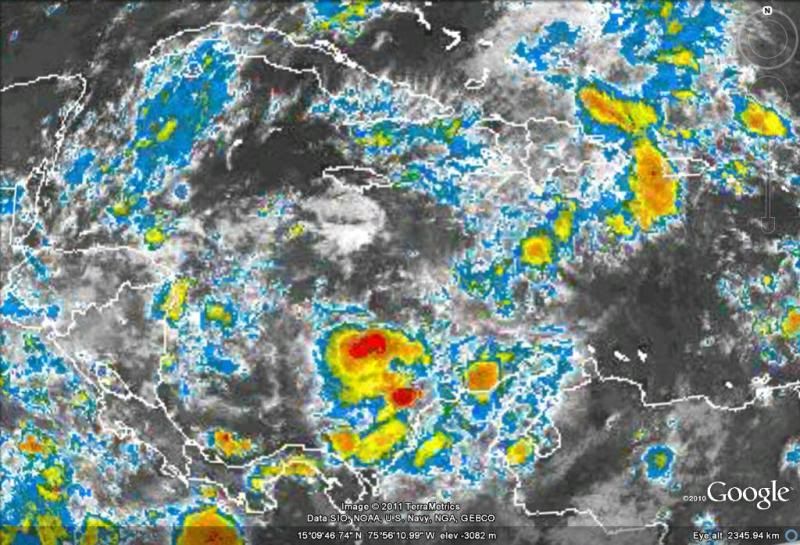
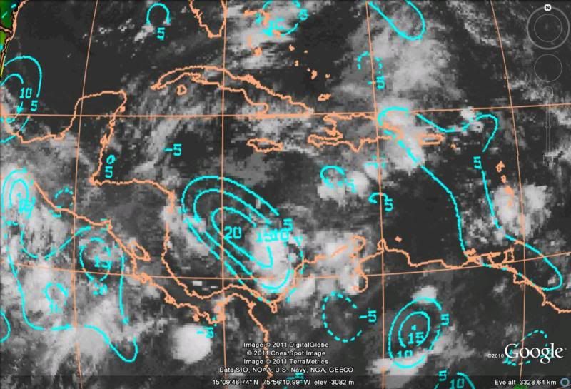
Tropical wave is now in the central Caribbean.
I'll be paying attention now over the next few days to the tropical wave now as it moves westward towards the NW Caribbean.
Currently surface pressures in the central Caribbean are low and slightly lower than 24 hrs ago.
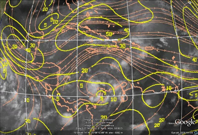
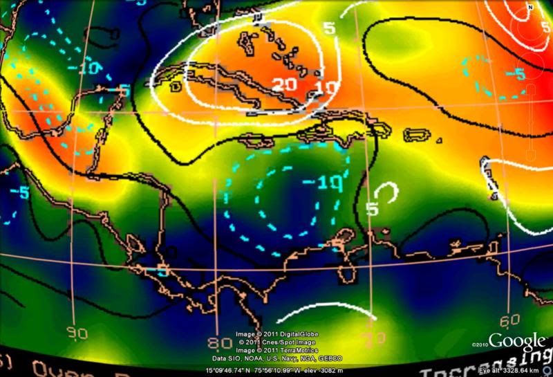
Upper level shear is decreasing along the tropical wave axis.
Surface convergence is high but UL divergence is not that high.
Convection is limited but should get going specially east of Nicaragua during the day today and tomorrow.
It still has no real model support from GFS other than just forecasting a broad area of low pressure developing in the NW Caribbean and no support in the last couple of ECMWF runs.
The only models developing it is the CMC and NAM, rather count them out unless the GFS & Euro joins them.
I'll be paying attention now over the next few days to the tropical wave now as it moves westward towards the NW Caribbean.
Currently surface pressures in the central Caribbean are low and slightly lower than 24 hrs ago.
Upper level shear is decreasing along the tropical wave axis.
Surface convergence is high but UL divergence is not that high.
Convection is limited but should get going specially east of Nicaragua during the day today and tomorrow.
It still has no real model support from GFS other than just forecasting a broad area of low pressure developing in the NW Caribbean and no support in the last couple of ECMWF runs.
The only models developing it is the CMC and NAM, rather count them out unless the GFS & Euro joins them.
0 likes
Who is online
Users browsing this forum: RomP and 154 guests