Strong Wave approaching Islands
Moderator: S2k Moderators
Forum rules

The posts in this forum are NOT official forecasts and should not be used as such. They are just the opinion of the poster and may or may not be backed by sound meteorological data. They are NOT endorsed by any professional institution or STORM2K. For official information, please refer to products from the National Hurricane Center and National Weather Service.
-
South Texas Storms

- Professional-Met

- Posts: 4246
- Joined: Thu Jun 24, 2010 12:28 am
- Location: Houston, TX
Re: Strong Wave approaching Islands
Ivan did it get torn apart by wind shear in the 18z GFS? I don't see it anymore at 144 hours.
0 likes
-
Ivanhater

- Storm2k Moderator

- Posts: 11166
- Age: 39
- Joined: Fri Jul 01, 2005 8:25 am
- Location: Pensacola
Re: Strong Wave approaching Islands
South Texas Storms wrote:Ivan did it get torn apart by wind shear in the 18z GFS? I don't see it anymore at 144 hours.
Similar to the 12z GFS so far...remember the 12z GFS never fully developed this but did show a strong wave moving into the Gulf.
Through 144 hours...that is the wave south of Cuba

0 likes
Michael
-
South Texas Storms
- Professional-Met
- Posts: 4246
- Joined: Thu Jun 24, 2010 12:28 am
- Location: Houston, TX
Re: Strong Wave approaching Islands
Oh yeah I still see it on the model now. It shows it just east of the Yucatan at 156 hours.
0 likes


-
cycloneye

- Admin

- Posts: 148733
- Age: 69
- Joined: Thu Oct 10, 2002 10:54 am
- Location: San Juan, Puerto Rico
Re:
HurricaneBrain wrote:We should be seeing a code yellow soon from the NHC.
No mention at 8 PM TWO.
0 likes
Visit the Caribbean-Central America Weather Thread where you can find at first post web cams,radars
and observations from Caribbean basin members Click Here
and observations from Caribbean basin members Click Here
-
HurricaneBrain

- S2K Supporter

- Posts: 520
- Joined: Thu Jun 30, 2011 2:07 pm
Re: Re:
cycloneye wrote:HurricaneBrain wrote:We should be seeing a code yellow soon from the NHC.
No mention at 8 PM TWO.
They're probably going to wait a few days before they mention it.
0 likes

-
South Texas Storms
- Professional-Met
- Posts: 4246
- Joined: Thu Jun 24, 2010 12:28 am
- Location: Houston, TX
Re: Strong Wave approaching Islands
So how many models now show this possibly developing in about a week? GFS, Euro, NOGAPS, am I right? What about the CMC?
0 likes


Re: Strong Wave approaching Islands
0 likes
-
cycloneye
- Admin
- Posts: 148733
- Age: 69
- Joined: Thu Oct 10, 2002 10:54 am
- Location: San Juan, Puerto Rico
Re: Strong Wave approaching Islands
If this wave persists with convection for the next 24 hours,I would not be surprised to see invest 96L up.
0 likes
Visit the Caribbean-Central America Weather Thread where you can find at first post web cams,radars
and observations from Caribbean basin members Click Here
and observations from Caribbean basin members Click Here
-
Rgv20

- S2K Supporter
- Posts: 2466
- Age: 39
- Joined: Wed Jan 05, 2011 5:42 pm
- Location: Edinburg/McAllen Tx
I put up this post yesterday on Global Model Runs Discussion http://www.storm2k.org/phpbb2/viewtopic.php?f=31&t=104813&start=2180 and now the GFS and ECMWF trying to hint on something getting going in the Caribbean.
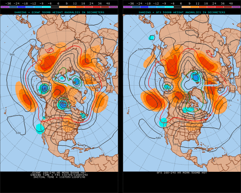
The ECMWF and GFS do not forecast any tropical development in the longer range but looking at the pattern setting up from next Tuesday (July12) thru Friday (July15) something could possibly develop in the Caribbean. Normally this time of year the Ridge (ex. 588mb height) would extend all the way south to the Caribbean normally providing subsidence.
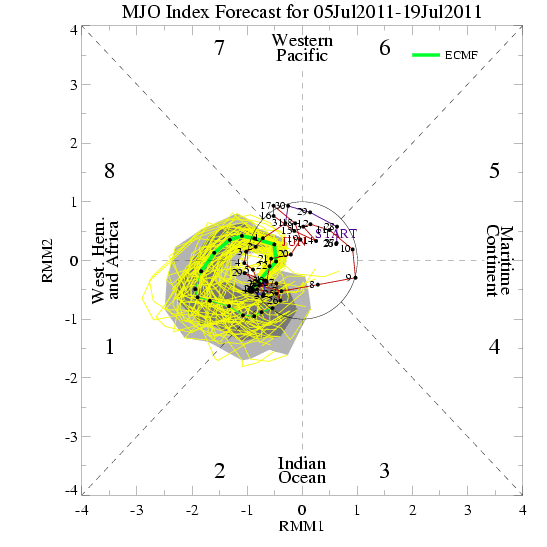
And supporting this idea would be the MJO still going strong on that time frame.
ECMWF Ensembles
GEFS
Obviously nothing to get excited about but just something to watch in the coming days.

0 likes
The following post is NOT an official forecast and should not be used as such. It is just the opinion of the poster and may or may not be backed by sound meteorological data. It is NOT endorsed by any professional institution including storm2k.org For Official Information please refer to the NHC and NWS products.

-
HurricaneBrain
- S2K Supporter
- Posts: 520
- Joined: Thu Jun 30, 2011 2:07 pm
Maybe code yellow at 1 AM. I'm thinking tomorrow they will give it 10-20%
Last edited by HurricaneBrain on Thu Jul 07, 2011 1:09 am, edited 2 times in total.
0 likes
-
HurricaneBrain
- S2K Supporter
- Posts: 520
- Joined: Thu Jun 30, 2011 2:07 pm
-
stormreader
Re: Strong Wave approaching Islands
RGV mentioned that normally the ridge would extend further south at this time of year and that you would see quite a bit more subsidence in the Carribean. I believe that he is right. If you look at the Carribean area right now you see an enormous amount of convection. I think its very early to be seeing this.

0 likes

Re: Strong Wave approaching Islands
7N 49W showing good MIMIC-TPW convergence.
Big question if it can clear the SA coast.
All models except CMC say yes. At least CMC now acknowledges its existence.
Very nice UL Outflow / Anti-cyclone.
Good PV definition at 320K, 850 & 700mb. Clear above.
ASCAT does not show anything on the surface yet.


Big question if it can clear the SA coast.
All models except CMC say yes. At least CMC now acknowledges its existence.
Very nice UL Outflow / Anti-cyclone.
Good PV definition at 320K, 850 & 700mb. Clear above.
ASCAT does not show anything on the surface yet.
0 likes
-
cycloneye
- Admin
- Posts: 148733
- Age: 69
- Joined: Thu Oct 10, 2002 10:54 am
- Location: San Juan, Puerto Rico
Re: Strong Wave approaching Islands
8 AM EDT TWO
AN AREA OF DISTURBED WEATHER ASSOCIATED WITH A TROPICAL WAVE IS
CENTERED ABOUT 600 MILES EAST-SOUTHEAST OF THE SOUTHERN WINDWARD
ISLANDS. THIS ACTIVITY IS EXPECTED TO SPREAD WESTWARD OVER NORTHERN
SOUTH AMERICA AND THE SOUTHERN WINDWARD ISLANDS DURING THE NEXT DAY
OR TWO WITH NO SIGNIFICANT DEVELOPMENT. THERE IS A LOW CHANCE...10
PERCENT...OF THIS SYSTEM BECOMING A TROPICAL CYCLONE DURING THE
NEXT 48 HOURS.
0 likes
Visit the Caribbean-Central America Weather Thread where you can find at first post web cams,radars
and observations from Caribbean basin members Click Here
and observations from Caribbean basin members Click Here


-
Ivanhater
- Storm2k Moderator
- Posts: 11166
- Age: 39
- Joined: Fri Jul 01, 2005 8:25 am
- Location: Pensacola
Re: Strong Wave approaching Islands - 10%
On the map! I honestly thought they would have waited but it does look good this morning
[img]
Uploaded with ImageShack.us[/img]
[img]

Uploaded with ImageShack.us[/img]
0 likes
Michael
Who is online
Users browsing this forum: No registered users and 54 guests