
Strong Wave approaching Islands
Moderator: S2k Moderators
Forum rules

The posts in this forum are NOT official forecasts and should not be used as such. They are just the opinion of the poster and may or may not be backed by sound meteorological data. They are NOT endorsed by any professional institution or STORM2K. For official information, please refer to products from the National Hurricane Center and National Weather Service.
-
cycloneye

- Admin

- Posts: 148733
- Age: 69
- Joined: Thu Oct 10, 2002 10:54 am
- Location: San Juan, Puerto Rico
Re: Strong Wave approaching Islands - 10%
Trying to gain some latitude.
0 likes
Visit the Caribbean-Central America Weather Thread where you can find at first post web cams,radars
and observations from Caribbean basin members Click Here
and observations from Caribbean basin members Click Here

-
Ivanhater

- Storm2k Moderator

- Posts: 11166
- Age: 39
- Joined: Fri Jul 01, 2005 8:25 am
- Location: Pensacola
Re: Strong Wave approaching Islands - 10%
12z GFS still sniffing out development of this wave once near the Yucatan

0 likes
Michael

-
cycloneye
- Admin
- Posts: 148733
- Age: 69
- Joined: Thu Oct 10, 2002 10:54 am
- Location: San Juan, Puerto Rico
Re: Strong Wave approaching Islands - 10%
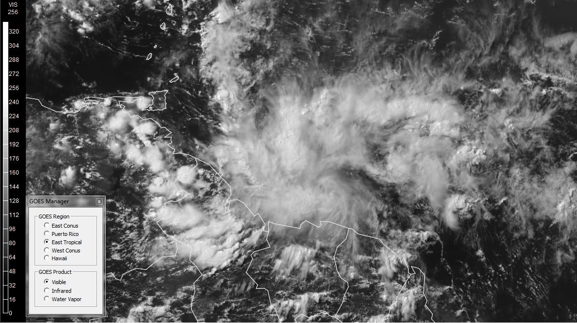
Remains at 10%.
AN AREA OF DISTURBED WEATHER ASSOCIATED WITH A TROPICAL WAVE IS
CENTERED ABOUT 550 MILES EAST-SOUTHEAST OF THE SOUTHERN WINDWARD
ISLANDS. ALTOUGH DEVELOPMENT OF THIS SYSTEM IS NOT EXPECTED...
LOCALLY HEAVY RAINS ARE POSSIBLE OVER NORTHERN SOUTH AMERICA AND
THE SOUTHERN WINDWARD ISLANDS DURING THE NEXT DAY OR TWO. THERE IS
A LOW CHANCE...10 PERCENT...OF THIS SYSTEM BECOMING A TROPICAL
CYCLONE DURING THE NEXT 48 HOURS.
0 likes
Visit the Caribbean-Central America Weather Thread where you can find at first post web cams,radars
and observations from Caribbean basin members Click Here
and observations from Caribbean basin members Click Here


-
Ivanhater
- Storm2k Moderator
- Posts: 11166
- Age: 39
- Joined: Fri Jul 01, 2005 8:25 am
- Location: Pensacola
Re: Strong Wave approaching Islands - 10%
Interesting..looks like a surface low is forming

0 likes
Michael
-
HouTXmetro

- Category 5

- Posts: 3949
- Joined: Sun Jun 13, 2004 6:00 pm
- Location: District of Columbia, USA
-
Ivanhater
- Storm2k Moderator
- Posts: 11166
- Age: 39
- Joined: Fri Jul 01, 2005 8:25 am
- Location: Pensacola
Re: Strong Wave approaching Islands - 10%
If it was not for S.A, this looks to be organizing rather quickly...certainly a contender down the road...
0 likes
Michael

-
cycloneye
- Admin
- Posts: 148733
- Age: 69
- Joined: Thu Oct 10, 2002 10:54 am
- Location: San Juan, Puerto Rico
Re: Strong Wave approaching Islands - 10%
Remains at 10%
A TROPICAL WAVE LOCATED ABOUT 400 MILES EAST-SOUTHEAST OF THE
SOUTHERN WINDWARD ISLANDS CONTINUES TO PRODUCE A DISORGANIZED AREA
OF SHOWERS AND THUNDERSTORMS. ALTHOUGH SIGNIFICANT DEVELOPMENT OF
THIS SYSTEM IS NOT EXPECTED...LOCALLY HEAVY RAINS ARE POSSIBLE OVER
NORTHERN SOUTH AMERICA AND THE SOUTHERN WINDWARD ISLANDS DURING THE
NEXT DAY OR TWO. THERE IS A LOW CHANCE...10 PERCENT...OF THIS
SYSTEM BECOMING A TROPICAL CYCLONE DURING THE NEXT 48 HOURS.
0 likes
Visit the Caribbean-Central America Weather Thread where you can find at first post web cams,radars
and observations from Caribbean basin members Click Here
and observations from Caribbean basin members Click Here
-
Rgv20

- S2K Supporter

- Posts: 2466
- Age: 39
- Joined: Wed Jan 05, 2011 5:42 pm
- Location: Edinburg/McAllen Tx
Looking at forecast for the 500mb pattern by around mid week, it could possibly support something developing in the Caribbean.
12zGFS Ensembles Wed 07/13
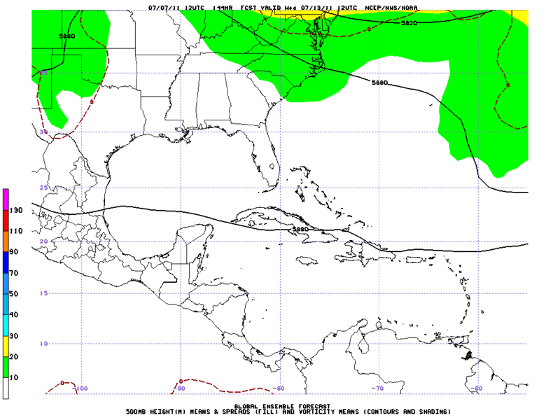
12zECMWF Ensembles Wed 07/13
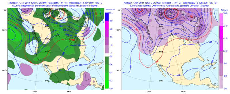
12zGFS Ensembles Wed 07/13
12zECMWF Ensembles Wed 07/13
0 likes
The following post is NOT an official forecast and should not be used as such. It is just the opinion of the poster and may or may not be backed by sound meteorological data. It is NOT endorsed by any professional institution including storm2k.org For Official Information please refer to the NHC and NWS products.

Re: Strong Wave approaching Islands - 10%
Looks that way Ivan...I would have tagged this guy 96L instead of the blob up in the GOM.....this one smells like it has potential down the road...
0Z GFS does nothing with it really.....
0Z GFS does nothing with it really.....
0 likes
Re: Strong Wave approaching Islands - 10%
current wind shear.....anticyclone over the area with light shear....hmmm
http://tropic.ssec.wisc.edu/real-time/w ... oom=&time=
http://tropic.ssec.wisc.edu/real-time/w ... oom=&time=
0 likes
-
South Texas Storms

- Professional-Met

- Posts: 4246
- Joined: Thu Jun 24, 2010 12:28 am
- Location: Houston, TX
Re: Strong Wave approaching Islands - 10%
ROCK wrote:current wind shear.....anticyclone over the area with light shear....hmmm
http://tropic.ssec.wisc.edu/real-time/w ... oom=&time=
Hmm I wonder why the models aren't doing much with it...
Maybe that will change in the coming days.
0 likes

Re: Strong Wave approaching Islands - 10%
South Texas Storms wrote:
Hmm I wonder why the models aren't doing much with it...
Maybe that will change in the coming days.
The 12z runs of NOGAPS and the CMC were developing a tropical cyclone over Central America but I'm not sure if the origin is this wave, and we know that those two models are not the most reliable out there
0 likes
Re: Strong Wave approaching Islands - 10%
South Texas Storms wrote:ROCK wrote:current wind shear.....anticyclone over the area with light shear....hmmm
http://tropic.ssec.wisc.edu/real-time/w ... oom=&time=
Hmm I wonder why the models aren't doing much with it...
Maybe that will change in the coming days.
they are doing something with it but not the GFS...seems its being rather conservative,,,,even long range you dont see the phatom storms it used to spin up...maybe its been tweaked some this year....
0 likes

Will have to wait until this wave starts gaining some latitude and emerges over the central/western Caribbean in a few days. With the ridge finding a home in the central US it means that the western Caribbean will have lower heights so it should gain some latitude. Not sure if it will get into the GOM, most likely into the Yucatan and into the BOC.
0 likes
-
wxman57

- Moderator-Pro Met

- Posts: 23120
- Age: 68
- Joined: Sat Jun 21, 2003 8:06 pm
- Location: Houston, TX (southwest)
Re: Strong Wave approaching Islands
I was hoping this system might bring some moisture to TX/LA around next weekend. However, looking at the projected mean winds aloft later next week, there's a big high building right over TX/LA and the NW Gulf. Flow is straight east to west in the SW and western Caribbean, across the Yucatan and into south Mexico. That would make it hard for the system to gain any latitude. If it was to develop, it would probably not get above 20N.
0 likes
Who is online
Users browsing this forum: pepecool20 and 76 guests