Global model runs discussion
Moderator: S2k Moderators
-
cycloneye

- Admin

- Posts: 149511
- Age: 69
- Joined: Thu Oct 10, 2002 10:54 am
- Location: San Juan, Puerto Rico
Re: Global Model Runs Discussion
The reliable models are for the most part quiet right now (Except the always bullish Canadian )  so dont expect tropical development anytime soon. Let's see when they will start to sniff something.
0 likes
Visit the Caribbean-Central America Weather Thread where you can find at first post web cams,radars
and observations from Caribbean basin members Click Here
and observations from Caribbean basin members Click Here

Re: Global Model Runs Discussion
CMC has backed off with a weak low or wave moving up the spine of FL....good news for you guys...
0 likes

Re: Global Model Runs Discussion
That low would be good news for us Lake O is 4 ft below normal.
0 likes
-
srainhoutx

- S2K Supporter

- Posts: 6919
- Age: 68
- Joined: Sun Jan 14, 2007 11:34 am
- Location: Haywood County, NC
- Contact:
Re: Global Model Runs Discussion
ROCK wrote:CMC has backed off with a weak low or wave moving up the spine of FL....good news for you guys...
Actually the CMC shows a TC riding up the SE and MA Coast, but of course it's totally on it's own and has no other model support.
0 likes
Carla/Alicia/Jerry(In The Eye)/Michelle/Charley/Ivan/Dennis/Katrina/Rita/Wilma/Ike/Harvey
Member: National Weather Association
Wx Infinity Forums
http://wxinfinity.com/index.php
Facebook.com/WeatherInfinity
Twitter @WeatherInfinity
Member: National Weather Association
Wx Infinity Forums
http://wxinfinity.com/index.php
Facebook.com/WeatherInfinity
Twitter @WeatherInfinity
-
SETXWXLADY
- Tropical Storm

- Posts: 216
- Joined: Wed May 20, 2009 3:26 pm
- Location: SE TX Orange County
Re: Global Model Runs Discussion
srainhoutx wrote:ROCK wrote:CMC has backed off with a weak low or wave moving up the spine of FL....good news for you guys...
Actually the CMC shows a TC riding up the SE and MA Coast, but of course it's totally on it's own and has no other model support.
CMC long range was teasing us with rain last night. This last model run shows a storm moving west through the gulf at the end of the run. Who knows. One of these days it might be right.

0 likes
-
cycloneye
- Admin
- Posts: 149511
- Age: 69
- Joined: Thu Oct 10, 2002 10:54 am
- Location: San Juan, Puerto Rico
Re: Global Model Runs Discussion
Is only one model (NOGAPS) that has this strong wave near the Windward Islands,but you know the drill about only one model showing something.

http://moe.met.fsu.edu/cgi-bin/ngptc2.c ... =Animation
http://moe.met.fsu.edu/cgi-bin/ngptc2.c ... =Animation
0 likes
Visit the Caribbean-Central America Weather Thread where you can find at first post web cams,radars
and observations from Caribbean basin members Click Here
and observations from Caribbean basin members Click Here
-
plasticup
-
Rgv20

- S2K Supporter
- Posts: 2466
- Age: 39
- Joined: Wed Jan 05, 2011 5:42 pm
- Location: Edinburg/McAllen Tx
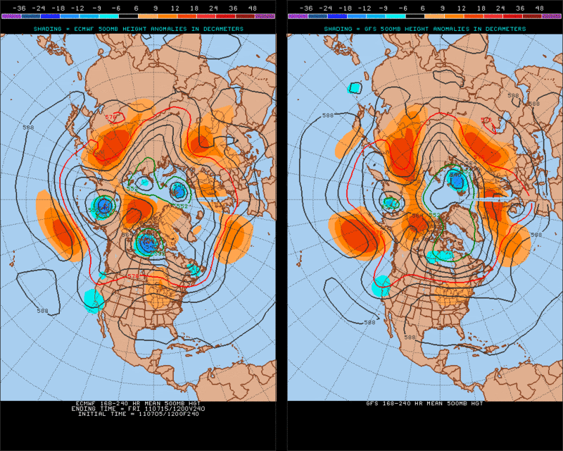
The ECMWF and GFS do not forecast any tropical development in the longer range but looking at the pattern setting up from next Tuesday (July12) thru Friday (July15) something could possibly develop in the Caribbean. Normally this time of year the Ridge (ex. 588mb height) would extend all the way south to the Caribbean normally providing subsidence.
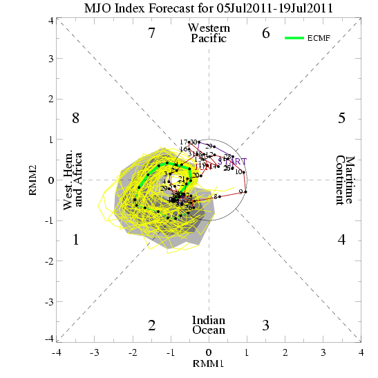
And supporting this idea would be the MJO still going strong on that time frame.
ECMWF Ensembles
GEFS

Obviously nothing to get excited about but just something to watch in the coming days.
And supporting this idea would be the MJO still going strong on that time frame.
ECMWF Ensembles
GEFS
Obviously nothing to get excited about but just something to watch in the coming days.
0 likes
The following post is NOT an official forecast and should not be used as such. It is just the opinion of the poster and may or may not be backed by sound meteorological data. It is NOT endorsed by any professional institution including storm2k.org For Official Information please refer to the NHC and NWS products.
-
cycloneye
- Admin
- Posts: 149511
- Age: 69
- Joined: Thu Oct 10, 2002 10:54 am
- Location: San Juan, Puerto Rico
Re: Global Model Runs Discussion
0 likes
Visit the Caribbean-Central America Weather Thread where you can find at first post web cams,radars
and observations from Caribbean basin members Click Here
and observations from Caribbean basin members Click Here
-
cycloneye
- Admin
- Posts: 149511
- Age: 69
- Joined: Thu Oct 10, 2002 10:54 am
- Location: San Juan, Puerto Rico
Re: Global Model Runs Discussion
GFS shows at 160 hours a weak low pressure emerging Africa and moving thru the Tropical Atlantic until around 40W,where it weakens. I haven't seen other models with this so far,so let's see if they join GFS, or that model stays alone.
GFS animation
GFS animation
0 likes
Visit the Caribbean-Central America Weather Thread where you can find at first post web cams,radars
and observations from Caribbean basin members Click Here
and observations from Caribbean basin members Click Here


Re: Global Model Runs Discussion
cycloneye wrote:GFS shows at 160 hours a weak low pressure emerging Africa and moving thru the Tropical Atlantic until around 40W,where it weakens. I haven't seen other models with this so far,so let's see if they join GFS, or that model stays alone.
GFS animation
It looks to me like the low it shows forming is a direct result of the wave coming off Africa right now.
0 likes
-
plasticup
Re: Global Model Runs Discussion
BigA wrote:cycloneye wrote:GFS shows at 160 hours a weak low pressure emerging Africa and moving thru the Tropical Atlantic until around 40W,where it weakens. I haven't seen other models with this so far,so let's see if they join GFS, or that model stays alone.
GFS animation
It looks to me like the low it shows forming is a direct result of the wave coming off Africa right now.
That's how I read it too. But the wave stays low and splats into French Guiana without development.
Actually, I don't see much excitement in any of the models, even at 300+ hours. Which is crazy because you can usually guarantee something ridiculous in the 300 hour models.
0 likes
Re: Global Model Runs Discussion
some food for thought.....we are not into the heart of summer yet and look at the potential out there....the GOM is baking...
http://wxmaps.org/pix/hurpot.html#ATL
http://wxmaps.org/pix/hurpot.html#ATL
0 likes
-
CYCLONE MIKE
- Category 5

- Posts: 2183
- Joined: Tue Aug 31, 2004 6:04 pm
- Location: Gonzales, LA
Re: Global Model Runs Discussion
Doesn't seem to make much difference how hot the gulf is. Hurricanes often blow up in the south or central part but almost always lose steam as they approach the coast. Dry air and shear always seem to do a number on most major storms. I know not all, but a good 90-95% of them. Not complaining becasue what we have had in the recent years was bad enough, just saying.
0 likes

I suspect its the size that makes a difference, if you've got a small tight system its outer flow won't be big enough for it to drag in dry air from the land until its already too close and the damage is done, whilst the biggies like your bigger storms will be taking in dry air for a good many hours before landfall.
0 likes
Personal Forecast Disclaimer:
The posts in this forum are NOT official forecast and should not be used as such. They are just the opinion of the poster and may or may not be backed by sound meteorological data. They are NOT endorsed by any professional institution or storm2k.org. For official information, please refer to the NHC and NWS products
The posts in this forum are NOT official forecast and should not be used as such. They are just the opinion of the poster and may or may not be backed by sound meteorological data. They are NOT endorsed by any professional institution or storm2k.org. For official information, please refer to the NHC and NWS products
-
cycloneye
- Admin
- Posts: 149511
- Age: 69
- Joined: Thu Oct 10, 2002 10:54 am
- Location: San Juan, Puerto Rico
Re: Global Model Runs Discussion
For what it's worth,GFS has a Tropical Storm in the SW Caribbean by 168 hours. It looks like monsoon origin as it comes from the EPAC. See animation here I haven't seem other models with this,but if anyone sees something,post them here.

Uploaded by imageshack.us
Uploaded by imageshack.us
0 likes
Visit the Caribbean-Central America Weather Thread where you can find at first post web cams,radars
and observations from Caribbean basin members Click Here
and observations from Caribbean basin members Click Here
Re: Global Model Runs Discussion
cycloneye wrote:For what it's worth,GFS has a Tropical Storm in the SW Caribbean by 168 hours. It looks like monsoon origin as it comes from the EPAC. See animation here I haven't seem other models with this,but if anyone sees something,post them here.
Uploaded by imageshack.us
NOGAPS has been showing the same thing but it was hard to figure out if it was the wave moving across or monsoon related...
0 likes
Re:
KWT wrote:I suspect its the size that makes a difference, if you've got a small tight system its outer flow won't be big enough for it to drag in dry air from the land until its already too close and the damage is done, whilst the biggies like your bigger storms will be taking in dry air for a good many hours before landfall.
That is a good point but there are your one offs that are just so big that dont weaken...IE IKE who was gaining up until landfall. Ike was so big it filled the GOM. plus it never really turned north until after landfall. Now Rita had made her turn like Lily and headed north many hours before landfall. They were big also but because they were heading north the outflow sucked in massive amounts of dry air.
0 likes
-
cycloneye
- Admin
- Posts: 149511
- Age: 69
- Joined: Thu Oct 10, 2002 10:54 am
- Location: San Juan, Puerto Rico
Re: Global Model Runs Discussion
For a second run in a row,GFS develops a Tropical Storm in the SW Caribbean,but land interaction wont let it develop more,according to this model. It also has competition with a EPAC system on this 12z run. Will GFS be a loner or will other models follow?

Uploaded by imageshack.us
Uploaded by imageshack.us
0 likes
Visit the Caribbean-Central America Weather Thread where you can find at first post web cams,radars
and observations from Caribbean basin members Click Here
and observations from Caribbean basin members Click Here
Who is online
Users browsing this forum: No registered users and 71 guests