12z NOGAPS joins GFS on developing a cyclone in the SW Caribbean,but land interaction messes up with it not allowing a very strong system.
http://moe.met.fsu.edu/cgi-bin/ngptc2.c ... =Animation
Global model runs discussion
Moderator: S2k Moderators
-
cycloneye

- Admin

- Posts: 149510
- Age: 69
- Joined: Thu Oct 10, 2002 10:54 am
- Location: San Juan, Puerto Rico
Re: Global Model Runs Discussion
0 likes
Visit the Caribbean-Central America Weather Thread where you can find at first post web cams,radars
and observations from Caribbean basin members Click Here
and observations from Caribbean basin members Click Here

Is going to be a toss up for which side of C.A. a possible system gets going in the mid range forecast. It will all depend if it gets break from ridging to the north.
Euro also shows cyclogenisis but in the Pacific side, very close to the Mexican & C.A. coast may I add, so you can see that any ridging over done by the european model would mean that cyclogenisis would be in the Caribbean and or BOC.

Euro also shows cyclogenisis but in the Pacific side, very close to the Mexican & C.A. coast may I add, so you can see that any ridging over done by the european model would mean that cyclogenisis would be in the Caribbean and or BOC.
0 likes

Re: Global Model Runs Discussion
The problem with this system is not going to be the intensity but the rains, the GFS is showing lots of rain for several days in Central America, this could be another Agatha or another Stan, hopefully not but it needs to be monitored closely.
0 likes
-
cycloneye
- Admin
- Posts: 149510
- Age: 69
- Joined: Thu Oct 10, 2002 10:54 am
- Location: San Juan, Puerto Rico
Re: Global Model Runs Discussion
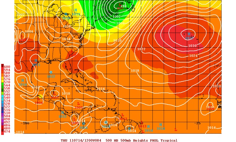
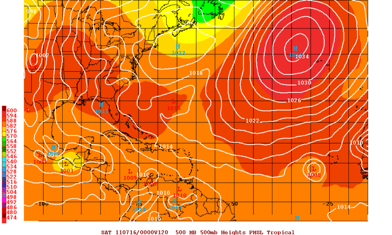
Third run in a row that GFS shows the SW Caribbean development. This is the 18z run.A caution is that in long range it goes very bullish in the BOC,but again is long range,over 250 hours.
At 168 hours.

Over 250 hours.

At 168 hours.
Over 250 hours.
0 likes
Visit the Caribbean-Central America Weather Thread where you can find at first post web cams,radars
and observations from Caribbean basin members Click Here
and observations from Caribbean basin members Click Here

Re: Global Model Runs Discussion
cycloneye wrote:Third run in a row that GFS shows the SW Caribbean development. This is the 18z run.A caution is that in long range it goes very bullish in the BOC,but again is long range,over 250 hours.
now there is the long range GFS that we know and love.....
0 likes
Re: Global Model Runs Discussion
All the glogal models (CMC, Euro, GFS, NOGAPS, UKMET) are in agreement about the development of a tropcial cyclone near Central America, I guess that in the next few days there is going to be more certainty about the location of the cyclogenesis, but this is becoming very interesting for me.
0 likes
-
cycloneye
- Admin
- Posts: 149510
- Age: 69
- Joined: Thu Oct 10, 2002 10:54 am
- Location: San Juan, Puerto Rico
Re: Global Model Runs Discussion
If you look at the 18z GFS run in animation,you will see almost a similar track like Arlene.
18z GFS loop
18z GFS loop
0 likes
Visit the Caribbean-Central America Weather Thread where you can find at first post web cams,radars
and observations from Caribbean basin members Click Here
and observations from Caribbean basin members Click Here
-
Rgv20

- S2K Supporter

- Posts: 2466
- Age: 39
- Joined: Wed Jan 05, 2011 5:42 pm
- Location: Edinburg/McAllen Tx
The 12zECMWF Ensembles by 168hrs shows a lot of uncertainties on the sea level pressure around Central America.
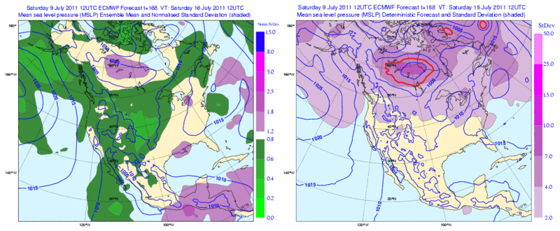
This is an explanation on how to read the 2 maps above courtesy of the ECMWF page.
Example of the new ensemble mean and spread web product. The contours show the forecast mean sea-level pressure (MSLP) field for 6 days ahead from the ensemble-mean (left panel) and the single higher resolution 'deterministic' forecast (right panel). The spread within the ensemble is also represented on each panel, using coloured shading. On the right panel, spread is simply represented as the standard deviation. Small values (light shading) indicate small spread differences between the ensemble members and hence high confidence, while large values indicate large differences and therefore low confidence. The shading on the left panel shows a normalised standard deviation, putting the spread into the context of the general ensemble behaviour, in that area, over the last 30 days. In this example the spread indicates relatively high confidence (green) in the high pressure area over the UK, but more uncertainty (purple) in the low pressure areas in the Mediterranean and Atlantic.
http://www.ecmwf.int/publications/cms/get/ecmwfnews/1273755207538
0 likes
The following post is NOT an official forecast and should not be used as such. It is just the opinion of the poster and may or may not be backed by sound meteorological data. It is NOT endorsed by any professional institution including storm2k.org For Official Information please refer to the NHC and NWS products.
-
Rgv20
- S2K Supporter
- Posts: 2466
- Age: 39
- Joined: Wed Jan 05, 2011 5:42 pm
- Location: Edinburg/McAllen Tx
Re:
NDG wrote:Is going to be a toss up for which side of C.A. a possible system gets going in the mid range forecast. It will all depend if it gets break from ridging to the north.
Euro also shows cyclogenisis but in the Pacific side, very close to the Mexican & C.A. coast may I add, so you can see that any ridging over done by the european model would mean that cyclogenisis would be in the Caribbean and or BOC.
Yeap its going to be interesting to see which basin is going to win out. It looks like if something were to develop its going to be of monsoonal origin so patience is going to be the keyword here.
0 likes
The following post is NOT an official forecast and should not be used as such. It is just the opinion of the poster and may or may not be backed by sound meteorological data. It is NOT endorsed by any professional institution including storm2k.org For Official Information please refer to the NHC and NWS products.
Re: Global Model Runs Discussion
LIke I said the 0Z GFS buries this into CA and scoots it over into the PAC.....
NOGAPS a little different.... developes it over land...nice...
https://www.fnmoc.navy.mil/wxmap_cgi/cg ... t=Tropical
NOGAPS a little different....
https://www.fnmoc.navy.mil/wxmap_cgi/cg ... t=Tropical
0 likes
-
Hurricaneman

- Category 5

- Posts: 7404
- Age: 45
- Joined: Tue Aug 31, 2004 3:24 pm
- Location: central florida
Re: Global Model Runs Discussion
Its in the long range, if it shows up like 30 runs from now it may be worth watching
0 likes
Re: Global Model Runs Discussion
Hurricaneman wrote:Its in the long range, if it shows up like 30 runs from now it may be worth watching
Actually the GFS has been showing the Central American system for 10 days or so, so there is consistency about cyclogenesis, the track is still uncertain though.
0 likes

Re: Global Model Runs Discussion
Looks like the high pressure sitting over the south will be our saving grace again this year.
0 likes
-
cycloneye
- Admin
- Posts: 149510
- Age: 69
- Joined: Thu Oct 10, 2002 10:54 am
- Location: San Juan, Puerto Rico
Re: Global Model Runs Discussion
We are posting the runs for the posible development on either side of Centralamerica in the thread for that,but I am now posting here the long range GFS at 12z,where it shows a pretty strong wave moving westward in the Atlantic and after it moves over Puerto Rico,at the end of run it is in the NGOM.We know the drill as I say many times about long range runs,but is always interesting to see the patterns that the model has many days ahead.
12z GFS animation
12z GFS animation
0 likes
Visit the Caribbean-Central America Weather Thread where you can find at first post web cams,radars
and observations from Caribbean basin members Click Here
and observations from Caribbean basin members Click Here
-
flwxwatcher
- Category 4

- Posts: 926
- Joined: Wed May 16, 2007 3:35 pm
- Location: Central Florida
Re: Global Model Runs Discussion
cycloneye wrote:We are posting the runs for the posible development on either side of Centralamerica in the thread for that,but I am now posting here the long range GFS at 12z,where it shows a pretty strong wave moving westward in the Atlantic and after it moves over Puerto Rico,at the end of run it is in the NGOM.We know the drill as I say many times about long range runs,but is always interesting to see the patterns that the model has many days ahead.
12z GFS animation
At the end of that run the GFS also is hinting at a system North of the Bahamas. It could be an interesting end of the month.
0 likes
-
cycloneye
- Admin
- Posts: 149510
- Age: 69
- Joined: Thu Oct 10, 2002 10:54 am
- Location: San Juan, Puerto Rico
Re: Global Model Runs Discussion
flwxwatcher wrote:cycloneye wrote:We are posting the runs for the posible development on either side of Centralamerica in the thread for that,but I am now posting here the long range GFS at 12z,where it shows a pretty strong wave moving westward in the Atlantic and after it moves over Puerto Rico,at the end of run it is in the NGOM.We know the drill as I say many times about long range runs,but is always interesting to see the patterns that the model has many days ahead.
12z GFS animation
At the end of that run the GFS also is hinting at a system North of the Bahamas. It could be an interesting end of the month.
Maybe is this well defined signature wave that GFS is latching on in the long range.

0 likes
Visit the Caribbean-Central America Weather Thread where you can find at first post web cams,radars
and observations from Caribbean basin members Click Here
and observations from Caribbean basin members Click Here
-
plasticup
Re: Global Model Runs Discussion
ROCK wrote:some food for thought.....we are not into the heart of summer yet and look at the potential out there....the GOM is baking...
http://wxmaps.org/pix/hurpot.html#ATL
Yep. Without some big heat engines (read: hurricanes) to dissipate the energy, the Gulf will only get hotter. It won't be good if we get into August without something churning the water in the Caribbean/Gulf, because by then the heat potential will be crazy.
0 likes
-
gatorcane

- S2K Supporter
- Posts: 23708
- Age: 48
- Joined: Sun Mar 13, 2005 3:54 pm
- Location: Boca Raton, FL
Re: Global Model Runs Discussion
flwxwatcher wrote:cycloneye wrote:We are posting the runs for the posible development on either side of Centralamerica in the thread for that,but I am now posting here the long range GFS at 12z,where it shows a pretty strong wave moving westward in the Atlantic and after it moves over Puerto Rico,at the end of run it is in the NGOM.We know the drill as I say many times about long range runs,but is always interesting to see the patterns that the model has many days ahead.
12z GFS animation
At the end of that run the GFS also is hinting at a system North of the Bahamas. It could be an interesting end of the month.
Nowhere to be found in the 18z gfs
http://www.nco.ncep.noaa.gov/pmb/nwprod ... n_324l.gif
0 likes
-
Rgv20
- S2K Supporter
- Posts: 2466
- Age: 39
- Joined: Wed Jan 05, 2011 5:42 pm
- Location: Edinburg/McAllen Tx
CV starting early? Not likely as the GFS is the only model forecasting this feature.
0zGFS with a possible TC at hour 84 (Thursday morning)
0zGFS 120hrs
0zGFS with a possible TC at hour 84 (Thursday morning)
0zGFS 120hrs
0 likes
The following post is NOT an official forecast and should not be used as such. It is just the opinion of the poster and may or may not be backed by sound meteorological data. It is NOT endorsed by any professional institution including storm2k.org For Official Information please refer to the NHC and NWS products.

Re: Global Model Runs Discussion
Rgv20 wrote:CV starting early? Not likely as the GFS is the only model forecasting this feature.
Although I agree it is only one run and we need more runs, the GFS has in my opinion been one of the best models throughout the years in forecasting cyclogensis in the E. Atlantic area. For the most part, it tends to pick up on the cape verde systems before the other models. Specifically 2008 July Hurricane Bertha which the GFS saw several runs before any of the other models picked up on it. Also, 2007 Aug. Hurricane Dean was predicted by the GFS well in advance of the other models. In other parts of the Atlantic basin I don't think the GFS has that edge. Let' see what happens tomorrow.
0 likes
Who is online
Users browsing this forum: No registered users and 43 guests