Development on either side of Central A? (Is invest 97L)
Moderator: S2k Moderators
Forum rules

The posts in this forum are NOT official forecasts and should not be used as such. They are just the opinion of the poster and may or may not be backed by sound meteorological data. They are NOT endorsed by any professional institution or STORM2K. For official information, please refer to products from the National Hurricane Center and National Weather Service.
-
lrak

- S2K Supporter

- Posts: 1770
- Age: 59
- Joined: Thu Jun 21, 2007 2:48 pm
- Location: Corpus Christi, TX
Re: Posible development on either side of Central America? - 0%
I wonder if that little ULL over the souther BOC will pull it north instead.
0 likes
AKA karl
Also
Personal Forecast Disclaimer:
My posts on this forum are NOT official forecast and should not be used as such. My posts are my basic observations and are definitely not backed by any "well some" meteorological knowledge. For official information, please refer to the NHC and NWS products.
Also
Personal Forecast Disclaimer:
My posts on this forum are NOT official forecast and should not be used as such. My posts are my basic observations and are definitely not backed by any "well some" meteorological knowledge. For official information, please refer to the NHC and NWS products.
-
Rgv20

- S2K Supporter
- Posts: 2466
- Age: 39
- Joined: Wed Jan 05, 2011 5:42 pm
- Location: Edinburg/McAllen Tx
It currently looks really nice, its going to be interesting to see if it can keep the convection going.

Strongest 850mb vorticity is half over land right now.
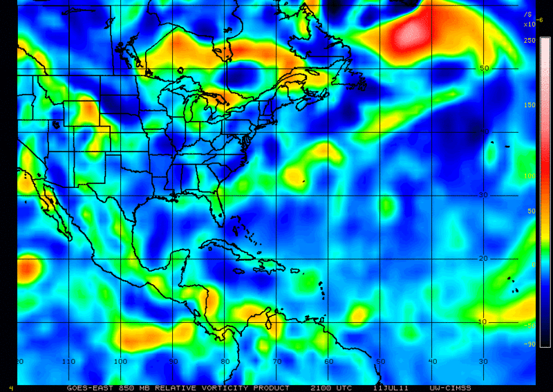
Strongest 850mb vorticity is half over land right now.
0 likes
The following post is NOT an official forecast and should not be used as such. It is just the opinion of the poster and may or may not be backed by sound meteorological data. It is NOT endorsed by any professional institution including storm2k.org For Official Information please refer to the NHC and NWS products.
-
cycloneye

- Admin

- Posts: 148733
- Age: 69
- Joined: Thu Oct 10, 2002 10:54 am
- Location: San Juan, Puerto Rico
Re: Posible development on either side of Central America? - 0%
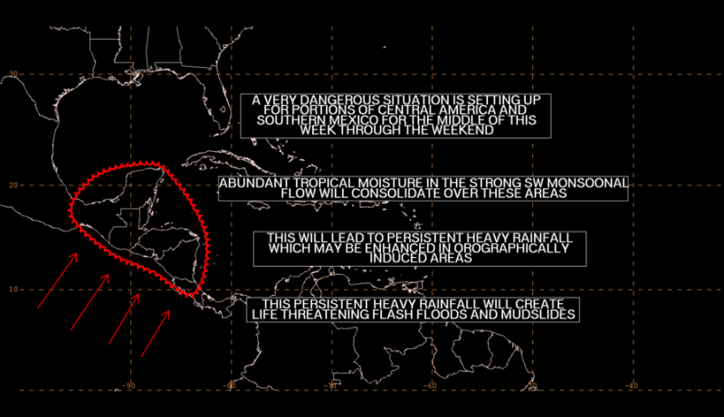
Extremely dangerous situation,if this pans out for the folks in Central America.
Discussion of EPAC at 22:05 UTC:
LOOKING AHEAD...A TROPICAL WAVE IN THE WESTERN CARIBBEAN WILL
CROSS THE YUCATAN PENINSULA TUE NIGHT. IT WILL BECOME ABSORBED
INTO AN UNUSUALLY STRONG MONSOON TROUGH BY THURSDAY. THE MONSOON
TROUGH IS EXPECTED TO SET UP OVER SOUTHERN MEXICO AND CENTRAL
AMERICA. SW MONSOONAL FLOW WILL STRENGTHEN OVER THE E PART OF
THE AREA. THIS STRENGTHENED MONSOONAL FLOW WILL ADVECT ABUNDANT
TROPICAL MOISTURE OVER CENTRAL AMERICA AND SOUTHERN MEXICO.
INDICATIONS ARE THAT THIS STRONG MONSOONAL FLOW WILL PERSIST
THROUGH AT LEAST THIS WEEKEND...AND PERHAPS INTO THE BEGINNING
OF NEXT WEEK. THIS WILL SET UP A VERY DANGEROUS SITUATION FOR
PARTS OF CENTRAL AMERICA AND SOUTHERN MEXICO WITH PROLONGED
HEAVY RAINFALL WHICH WILL LEAD TO FLASH FLOODING AND MUDSLIDES.
WE WILL CONTINUE TO MONITOR AND UPDATE THIS DEVELOPING DANGEROUS
SITUATION.
0 likes
Visit the Caribbean-Central America Weather Thread where you can find at first post web cams,radars
and observations from Caribbean basin members Click Here
and observations from Caribbean basin members Click Here
-
cycloneye
- Admin
- Posts: 148733
- Age: 69
- Joined: Thu Oct 10, 2002 10:54 am
- Location: San Juan, Puerto Rico
Re: Posible development on either side of Central America? - 0%
Up to 10%
A TROPICAL WAVE ACCOMPANIED BY A WEAK SURFACE LOW PRESSURE SYSTEM
NEAR THE COAST OF NICARAGUA IS PRODUCING A LARGE AREA OF CLOUDINESS
AND THUNDERSTORMS OVER THE WESTERN CARIBBEAN SEA AND ADJACENT
PORTIONS OF CENTRAL AMERICA. ALTHOUGH UPPER-LEVEL WINDS HAVE
IMPROVED ACROSS THE REGION...SIGNIFICANT DEVELOPMENT OF THIS
SYSTEM IS NOT EXPECTED DUE TO INTERACTION WITH LAND. THIS SYSTEM
HAS A LOW CHANCE...10 PERCENT...OF BECOMING A TROPICAL CYCLONE
DURING THE NEXT 48 HOURS AS IT MOVES SLOWLY WEST-NORTHWESTWARD OR
NORTHWESTWARD. REGARDLESS OF DEVELOPMENT...LOCALLY HEAVY RAINFALL
WILL CONTINUE OVER MUCH OF NICARAGUA...HONDURAS...BELIZE...AND
ADJACENT OFFSHORE ISLANDS DURING THE NEXT COUPLE OF DAYS.
0 likes
Visit the Caribbean-Central America Weather Thread where you can find at first post web cams,radars
and observations from Caribbean basin members Click Here
and observations from Caribbean basin members Click Here
-
Rgv20
- S2K Supporter
- Posts: 2466
- Age: 39
- Joined: Wed Jan 05, 2011 5:42 pm
- Location: Edinburg/McAllen Tx
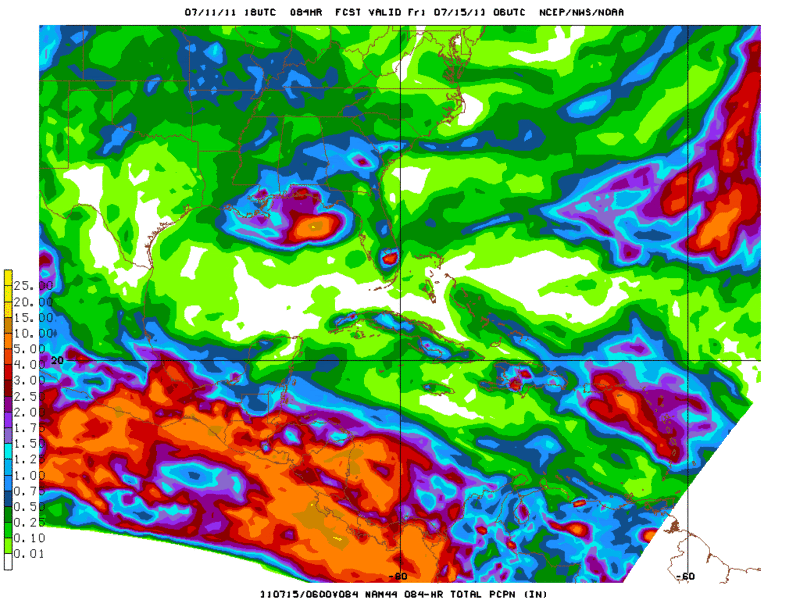
Dangerous indeed cycloneye, look at those impressive rainfall totals up and down the CA and Southern Mexico from the 18z NAM. 
Rainfall totals ending midnight Thursday.
Keep us updated Macrocane.
Rainfall totals ending midnight Thursday.
Keep us updated Macrocane.
0 likes
The following post is NOT an official forecast and should not be used as such. It is just the opinion of the poster and may or may not be backed by sound meteorological data. It is NOT endorsed by any professional institution including storm2k.org For Official Information please refer to the NHC and NWS products.
-
Rgv20
- S2K Supporter
- Posts: 2466
- Age: 39
- Joined: Wed Jan 05, 2011 5:42 pm
- Location: Edinburg/McAllen Tx
0 likes
The following post is NOT an official forecast and should not be used as such. It is just the opinion of the poster and may or may not be backed by sound meteorological data. It is NOT endorsed by any professional institution including storm2k.org For Official Information please refer to the NHC and NWS products.

Re: Posible development on either side of Central America? - 10%
Yeah  I'm impressed to see all that rain. Today most of the official meteorology agencies mentioned the possibility of heavy rains, but they have not mentioned yet that it could last for several days. In Central America 4 alerts (green, yellow, orange and red) are declared depending on the impact of the event, at the moment none of the countries have declared any type of alert but in El Salvador the government issued a "warning" for heavy rains.
0 likes

Macrocane Belize latest discussion from Met office finally states we could be in for some major rain event. NATIONAL METEOROLOGICAL SERVICE OF BELIZE
FORECAST DISCUSSION DATE: MONDAY 11TH JULY 2011 ( EVENING)
VERY UNSETTLED WX PREVAILED ACROSS BZE AND COASTAL WATERS TODAY.
SATPIX IMAGERY(VIS&IR) DISPLAYED A LARGE MASS OF MODERATE TO DEEP CONVECTION STRADDLING THE COAST OF NE HONDURAS AND NICARAGUA. SOME OF THE DEEP CONVECTION APPEARED TO BE INVADING PORTIONS OF MAINLAND HONDURAS AND NICARAGUA. WATER VAPOUR LOOP DEFINED WELL THE UPPER LVL TROUGH LOCATED OVER GUATEMALA/YUCATAN PENINSULA AND THE BAY OF CAMPECHE. THIS CHANNEL SHOWED WELL THE EXPLOSIVE DEVELOPMENT OF DEEP CONVECTION OVER NE HONDURAS AND THE CARIBBEAN COAST OF NICARAGUA.
SFC ANALYSIS FOR 12-00Z LOCATED THE TROPICAL WAVE AXIS ON THE CARIBBEAN COAST OF NICARAGUA. LOW PRESSURE TROUGH WAS OVER THE SW CARIBBEAN
GFS MODEL FCST BASED ON 18Z DATA SHOWS WELL THE EXTENSIVE AREAS OF +VORTMAX CNTRS FAVOURED TO DEVELOP ON BOTH THE PACIFIC COAST OD CNTRL AMERICA AND NEAR BZE THROUGH TUESDAY. A MORE OR LESS UNCHANGED PATTERN OF LOW PRESSURE WILL REMAIN OVER CNTRL AMERICA FOR SEVERAL DAYS. THIS WILL BE PARTICULARLY TRUE FOR SRN MEXICO/GUATEMALA/BZE AND HONDURAS/EL SALVADOR. SEEMS A GOOD CHANCE FOR THIS SITUATION TO WORSEN TOWARDS THE WEEKEND.
AT MID LVLS(500-400hPa)AREALTIVELY UNCHANGED EAST TO SE'LY FLOW WILL PREVAIL ACROSS BZE AND THE WRN CARIBBEAN. TOWARDS WEDNESDAY THE CYCLONIC DEVELOPMENT FAVOURED AT LOW LVLS WILL BECOME APPARENT ON THE EPAC COAST OF NICARAGUA/EL SALVADOR.
AT UPPER LVLS(300-200hPa)THE UPPER LVL TROUGH DISCUSSED EARLIER IS LOCATED OVER THE BAY OF CAMPECHE.WHILE THIS TROUGH APPEARS TO BE DAMPENING OUT YET ANOTHER ULT OVER THE CNTRL CARIBBEAN WILL ROTATE W-WRD AN REACH THE WRN CARIBBEAN/BZE AND THE YUCATAN PENINSULA BY THURSDAY MORNING. A POORLY FORMED HIGH WILL ALSO LINGER OVER THE WRN CARIBBEAN JUST EAST OF THE ULT.THE PATTERN HERE IS VERY DIVERGENT AND WILL SUPPORT EXTENDED PERIODS OF SHWR AND T-STORM DEVELOPMENT FOR A FEW DAYS.
PRECIP FCSTS SUGGESTS A RATHER EXPLOSIVE 24 HRS WRT TO RAINFALL FOR BZE AND COASTAL WATERS. WHEN THAT IS DONE THE RAINFALL WILL STILL NOT CEASE BECAUSE OF THE REASONS OUTLINED ABOVE. FOR TUESDAY RAINFALL AMOUNTS COULD RANGE BETWEEN 50 TO 75MM FOR CNTRL AND COASTAL PORTIONS OF BZE. THERE COULD WELL BE ISOLATED POCKETS OF VERY INTENSE RAINFALL IN THE REGION OF 100MM(4.00" APPROX.) NO DOUBT THE RISK OF FLASH FLOODS FOR LOW LYING PORTIONS OF THE COUNTRY APPEARS A DISTINCT POSSIBILITY.
FORECAST: CLOUDY TO OVERCAST SKIES; SEVERAL PERIODS OF SHOWERS AND THUNDERSTORMS WILL OCCUR OVER MOST AREAS.
EXTENDED: CONTINUING CLOUDY AND WET WEATHER
MARINE: EAST 15 -25KT BECMG GUSTY IN SHWRS/T-STORMS.. SEAS. ROUGH; SMALL CRAFT WARNING IN EFFECT.
FORECASTER: F.Tench Jr.
But on sat u look to be getting way more rain than us right now.
0 likes
Re: Posible development on either side of Central America? - 10%
0 likes
-
cycloneye
- Admin
- Posts: 148733
- Age: 69
- Joined: Thu Oct 10, 2002 10:54 am
- Location: San Juan, Puerto Rico
Re: Posible development on either side of Central America? - 10%
0 likes
Visit the Caribbean-Central America Weather Thread where you can find at first post web cams,radars
and observations from Caribbean basin members Click Here
and observations from Caribbean basin members Click Here

Re: Posible development on either side of Central America? - 10%
This is not a tropical model so take it with a grain of salt

0 likes
The following post is NOT an official forecast and should not be used as such. It is just the opinion of the poster and may or may not be backed by sound meteorological data. It is NOT endorsed by any professional institution including storm2k.org For Official Information please refer to the NHC and NWS products.
-
floridasun78
- Category 5

- Posts: 3755
- Joined: Sun May 17, 2009 10:16 pm
- Location: miami fl
Re: Posible development on either side of Central America? - 10%
0 likes

Re: Posible development on either side of Central America? - 10%
Looks like it is heading into the BOC.


0 likes
Re: Posible development on either side of Central America? - 10%
Shear in the GOM has been clearing out nicely from the anti-cyclone that was formed from 96L.
Looks like the remnants of the severe weather that went thru Detroit yesterday will rotate into the anti-cyclone and continue to support it.
http://www.goes.noaa.gov/HURRLOOPS/huwvloop.html
IMHO, chances look good for a TC spinup in the BOC.

Looks like the remnants of the severe weather that went thru Detroit yesterday will rotate into the anti-cyclone and continue to support it.
http://www.goes.noaa.gov/HURRLOOPS/huwvloop.html
IMHO, chances look good for a TC spinup in the BOC.
0 likes

Re: Posible development on either side of Central America? - 10%
GCANE wrote:Shear in the GOM has been clearing out nicely from the anti-cyclone that was formed from 96L.
Looks like the remnants of the severe weather that went thru Detroit yesterday will rotate into the anti-cyclone and continue to support it.
http://www.goes.noaa.gov/HURRLOOPS/huwvloop.html
IMHO, chances look good for a TC spinup in the BOC.
I don't see conditions in the BOC favorable for tropical development, both GFS & ECMWF show deteriorating UL conditions in the entire GOM including the BOC over the next 24-120 hrs, if not longer.
0 likes
Re: Posible development on either side of Central America? - 10%
It seems to be hanging onto its local anti-cyclone as the PV anomaly moves over land.
How heavy the convection will be, will dictate if it can maintain the anti-cyclone.
If it gets back over the water with the anti-cyclone, I think it may have a shot since it will push shear somewhat out of the way by redirecting UL winds.
Looking at the CONUS forecast, the mid-Plains ridge looks well entrenched and is even a warm-core.
So, if this does spin up in the BOC, at this point it looks like another Mexican landfall.
0 likes

Re: Posible development on either side of Central America? - 10%
model support waning attm....I agree with Cane maybe a BOC something but MX bound this early in the season while the ridge remains..
0 likes
Re: Posible development on either side of Central America?
WOW I find it very hard to believe that the NHC doesn't think that this thing over the YUCATAN has any chance of becoming a TC in the next 48 hrs. I'm just getting back from work but unless the UL enviroment is supposed really decline I would have it at 40-50% but then again I'm just a geek with no training. Maybe it won't get far enough in the BOC but looking at the vis, loop I'd think maybe 24hrs. or so and in the BOC things can spin up fast.
[img]
Uploaded with ImageShack.us[/img]
[img]

Uploaded with ImageShack.us[/img]
0 likes
The following post is NOT an official forecast and should not be used as such. It is just the opinion of the poster and may or may not be backed by sound meteorological data. It is NOT endorsed by any professional institution including storm2k.org For Official Information please refer to the NHC and NWS products.
Re: Posible development on either side of Central America?
^ Came in to post on that Yucatan swirl. Could bloom once it hits BOC.
Agree Tailgater. The animation of that makes it look like 100%.
The convection in the west Caribbean yesterday was telling you something.
Agree Tailgater. The animation of that makes it look like 100%.
The convection in the west Caribbean yesterday was telling you something.
0 likes
Re: Posible development on either side of Central America?
Sanibel wrote:^ Came in to post on that Yucatan swirl. Could bloom once it hits BOC.
Agree Tailgater. The animation of that makes it look like 100%.
The convection in the west Caribbean yesterday was telling you something.
Now that I've watched it awhile seems it be in the BOC long, maybe because it's rotating around a larger low pressure area?
0 likes
The following post is NOT an official forecast and should not be used as such. It is just the opinion of the poster and may or may not be backed by sound meteorological data. It is NOT endorsed by any professional institution including storm2k.org For Official Information please refer to the NHC and NWS products.
Who is online
Users browsing this forum: NotAHurricane and 58 guests