WPAC: MA-ON - Remnants
Moderator: S2k Moderators
-
StormingB81

- S2K Supporter

- Posts: 5676
- Age: 44
- Joined: Thu Aug 27, 2009 1:45 am
- Location: Rockledge, Florida
-
Typhoon Hunter
- WesternPacificWeather.com

- Posts: 1222
- Joined: Wed Oct 11, 2006 11:37 am
- Location: Tokyo
- Contact:
Re: WPAC: MA-ON - Severe Tropical Storm
phwxenthusiast wrote:Typhoon Hunter wrote:
Wow and I didn't seen to be wanting to bark up the wrong tree but I'm glad my thoughts yesterday echo those of a pro when it came to the crazy models runs.
The latest long range models are all over the place with UKMET taking Ma-on all the way west, ECMWF into Kyushu and GFS going for the full recurve.
so what do you think mr. james, when you going to Japan??
Haha a bit too early to say yet but if current forecasts held I'd probably travel on Sunday night or early Monday morning to Fukuoka in northern Kyushu then take it from there. After the typhoon I'd also be able to visit Sakurajima volcano, one of my favourites
http://youtu.be/Gbrw2fWimeo
0 likes


Re: WPAC: MA-ON - Severe Tropical Storm
That big eye is telling us this is not 50 kt, I think it's kind of obvious that Ma-on is already a typhoon at least its 1-min sustained winds.
0 likes
WTPN31 PGTW 130300
MSGID/GENADMIN/NAVMARFCSTCEN PEARL HARBOR HI/JTWC//
SUBJ/TROPICAL CYCLONE WARNING//
RMKS/
1. TROPICAL STORM 08W (MA-ON) WARNING NR 007
01 ACTIVE TROPICAL CYCLONE IN NORTHWESTPAC
MAX SUSTAINED WINDS BASED ON ONE-MINUTE AVERAGE
WIND RADII VALID OVER OPEN WATER ONLY
---
WARNING POSITION:
130000Z --- NEAR 19.6N 152.8E
MOVEMENT PAST SIX HOURS - 295 DEGREES AT 09 KTS
POSITION ACCURATE TO WITHIN 040 NM
POSITION BASED ON CENTER LOCATED BY SATELLITE
PRESENT WIND DISTRIBUTION:
MAX SUSTAINED WINDS - 050 KT, GUSTS 065 KT
WIND RADII VALID OVER OPEN WATER ONLY
RADIUS OF 034 KT WINDS - 080 NM NORTHEAST QUADRANT
070 NM SOUTHEAST QUADRANT
070 NM SOUTHWEST QUADRANT
080 NM NORTHWEST QUADRANT
REPEAT POSIT: 19.6N 152.8E
---
FORECASTS:
12 HRS, VALID AT:
131200Z --- 20.0N 150.5E
MAX SUSTAINED WINDS - 060 KT, GUSTS 075 KT
WIND RADII VALID OVER OPEN WATER ONLY
RADIUS OF 050 KT WINDS - 035 NM NORTHEAST QUADRANT
030 NM SOUTHEAST QUADRANT
030 NM SOUTHWEST QUADRANT
035 NM NORTHWEST QUADRANT
RADIUS OF 034 KT WINDS - 105 NM NORTHEAST QUADRANT
095 NM SOUTHEAST QUADRANT
095 NM SOUTHWEST QUADRANT
110 NM NORTHWEST QUADRANT
VECTOR TO 24 HR POSIT: 280 DEG/ 11 KTS
---
24 HRS, VALID AT:
140000Z --- 20.4N 148.2E
MAX SUSTAINED WINDS - 070 KT, GUSTS 085 KT
WIND RADII VALID OVER OPEN WATER ONLY
RADIUS OF 064 KT WINDS - 025 NM NORTHEAST QUADRANT
020 NM SOUTHEAST QUADRANT
025 NM SOUTHWEST QUADRANT
025 NM NORTHWEST QUADRANT
RADIUS OF 050 KT WINDS - 045 NM NORTHEAST QUADRANT
045 NM SOUTHEAST QUADRANT
045 NM SOUTHWEST QUADRANT
045 NM NORTHWEST QUADRANT
RADIUS OF 034 KT WINDS - 125 NM NORTHEAST QUADRANT
115 NM SOUTHEAST QUADRANT
115 NM SOUTHWEST QUADRANT
125 NM NORTHWEST QUADRANT
VECTOR TO 36 HR POSIT: 280 DEG/ 11 KTS
---
36 HRS, VALID AT:
141200Z --- 20.8N 145.9E
MAX SUSTAINED WINDS - 075 KT, GUSTS 090 KT
WIND RADII VALID OVER OPEN WATER ONLY
RADIUS OF 064 KT WINDS - 025 NM NORTHEAST QUADRANT
025 NM SOUTHEAST QUADRANT
025 NM SOUTHWEST QUADRANT
025 NM NORTHWEST QUADRANT
RADIUS OF 050 KT WINDS - 050 NM NORTHEAST QUADRANT
050 NM SOUTHEAST QUADRANT
050 NM SOUTHWEST QUADRANT
050 NM NORTHWEST QUADRANT
RADIUS OF 034 KT WINDS - 125 NM NORTHEAST QUADRANT
120 NM SOUTHEAST QUADRANT
120 NM SOUTHWEST QUADRANT
130 NM NORTHWEST QUADRANT
VECTOR TO 48 HR POSIT: 280 DEG/ 10 KTS
---
EXTENDED OUTLOOK:
48 HRS, VALID AT:
150000Z --- 21.2N 143.7E
MAX SUSTAINED WINDS - 080 KT, GUSTS 100 KT
WIND RADII VALID OVER OPEN WATER ONLY
RADIUS OF 064 KT WINDS - 030 NM NORTHEAST QUADRANT
030 NM SOUTHEAST QUADRANT
030 NM SOUTHWEST QUADRANT
030 NM NORTHWEST QUADRANT
RADIUS OF 050 KT WINDS - 055 NM NORTHEAST QUADRANT
055 NM SOUTHEAST QUADRANT
055 NM SOUTHWEST QUADRANT
055 NM NORTHWEST QUADRANT
RADIUS OF 034 KT WINDS - 130 NM NORTHEAST QUADRANT
120 NM SOUTHEAST QUADRANT
125 NM SOUTHWEST QUADRANT
130 NM NORTHWEST QUADRANT
VECTOR TO 72 HR POSIT: 285 DEG/ 10 KTS
---
72 HRS, VALID AT:
160000Z --- 22.0N 139.6E
MAX SUSTAINED WINDS - 090 KT, GUSTS 110 KT
WIND RADII VALID OVER OPEN WATER ONLY
RADIUS OF 064 KT WINDS - 035 NM NORTHEAST QUADRANT
035 NM SOUTHEAST QUADRANT
035 NM SOUTHWEST QUADRANT
035 NM NORTHWEST QUADRANT
RADIUS OF 050 KT WINDS - 065 NM NORTHEAST QUADRANT
060 NM SOUTHEAST QUADRANT
060 NM SOUTHWEST QUADRANT
065 NM NORTHWEST QUADRANT
RADIUS OF 034 KT WINDS - 135 NM NORTHEAST QUADRANT
130 NM SOUTHEAST QUADRANT
130 NM SOUTHWEST QUADRANT
135 NM NORTHWEST QUADRANT
VECTOR TO 96 HR POSIT: 285 DEG/ 08 KTS
---
LONG RANGE OUTLOOK:
NOTE...ERRORS FOR TRACK HAVE AVERAGED NEAR 250 NM
ON DAY 4 AND 350 NM ON DAY 5... AND FOR INTENSITY
NEAR 20 KT EACH DAY.
---
96 HRS, VALID AT:
170000Z --- 22.9N 136.2E
MAX SUSTAINED WINDS - 100 KT, GUSTS 125 KT
WIND RADII VALID OVER OPEN WATER ONLY
VECTOR TO 120 HR POSIT: 315 DEG/ 08 KTS
---
120 HRS, VALID AT:
180000Z --- 25.1N 133.8E
MAX SUSTAINED WINDS - 110 KT, GUSTS 135 KT
WIND RADII VALID OVER OPEN WATER ONLY
---
REMARKS:
130300Z POSITION NEAR 19.7N 152.2E.
TROPICAL STORM (TS) 08W (MA-ON), LOCATED APPROXIMATELY 700 NM
EAST-SOUTHEAST OF IWO TO, JAPAN, HAS TRACKED WEST-NORTHWESTWARD AT
09 KNOTS OVER THE PAST SIX HOURS. MAXIMUM SIGNIFICANT WAVE HEIGHT AT
130000Z IS 15 FEET. NEXT WARNINGS AT 130900Z, 131500Z, 132100Z AND
140300Z.//
NNNN
0 likes
-
rdhdstpchld
- Tropical Depression

- Posts: 79
- Joined: Mon May 09, 2011 3:47 am
Re:
StormingB81 wrote:Here in Okinawa they just sent out an all hands email saying to prepare for the hazards of this potential dangerous storm! Looks like they are not going ot take any chances
That's funny...did they do anything similar for Songda? and this one is proj'd to turn...figures they'd get it backwards...
0 likes
-
Rgv20

- S2K Supporter
- Posts: 2466
- Age: 39
- Joined: Wed Jan 05, 2011 5:42 pm
- Location: Edinburg/McAllen Tx
Taking a closer look at the 12zGFS Ensembles, most of the members are west of the operational run by day 6.
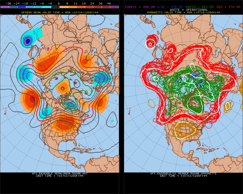
Meanwhile the 12zEuro has most of the support of its Ensembles members, albeit the speed of Ma-on is a tad slower than the operational run by day 7.
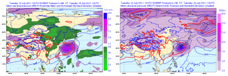
Meanwhile the 12zEuro has most of the support of its Ensembles members, albeit the speed of Ma-on is a tad slower than the operational run by day 7.
0 likes
The following post is NOT an official forecast and should not be used as such. It is just the opinion of the poster and may or may not be backed by sound meteorological data. It is NOT endorsed by any professional institution including storm2k.org For Official Information please refer to the NHC and NWS products.
-
StormingB81
- S2K Supporter
- Posts: 5676
- Age: 44
- Joined: Thu Aug 27, 2009 1:45 am
- Location: Rockledge, Florida
Re: Re:
rdhdstpchld wrote:StormingB81 wrote:Here in Okinawa they just sent out an all hands email saying to prepare for the hazards of this potential dangerous storm! Looks like they are not going ot take any chances
That's funny...did they do anything similar for Songda? and this one is proj'd to turn...figures they'd get it backwards...
Not this early no, they did it aout 4 days in advance. However with what the models are predicting atleast they are doing it. Don't want the wekeend to hit and the thing goes straight instead of turn.
0 likes
-
StormingB81
- S2K Supporter
- Posts: 5676
- Age: 44
- Joined: Thu Aug 27, 2009 1:45 am
- Location: Rockledge, Florida
viewtopic.php?f=59&t=111121&hilit=&start=140
If this happends looks like the majoroty of it could miss land all together..Iwo To would have to watch out though.
If this happends looks like the majoroty of it could miss land all together..Iwo To would have to watch out though.
0 likes
-
Typhoon Hunter
- WesternPacificWeather.com
- Posts: 1222
- Joined: Wed Oct 11, 2006 11:37 am
- Location: Tokyo
- Contact:
Re: WPAC: MA-ON - Severe Tropical Storm
StormingB81 wrote:http://www.storm2k.org/phpbb2/viewtopic.php?f=59&t=111121&hilit=&start=140
If this happends looks like the majoroty of it could miss land all together..Iwo To would have to watch out though.
The link you posted is for this page of discussion.
I guess you're talking about GFS? As Rgv20 posted the 12z operational is an easterly outlier at the moment.
0 likes
-
StormingB81
- S2K Supporter
- Posts: 5676
- Age: 44
- Joined: Thu Aug 27, 2009 1:45 am
- Location: Rockledge, Florida
Re: WPAC: Tropical Depression 08W
Infdidoll, Did you take the bet? And it you did does anyone win on a recurve?
0 likes
-
ManilaTC

- WesternPacificWeather.com
- Posts: 593
- Age: 47
- Joined: Mon Oct 26, 2009 5:13 am
- Location: Mandaluyong City, Philippines
- Contact:
Re: WPAC: MA-ON - Severe Tropical Storm
GFS and CMC are banking on an early recurve scenario, heading towards the main Island of Honshu.
0 likes
The above post is NOT official and should not be used as such. It is my opinion and may or may not be backed by sound meteorological data. It is not endorsed by any professional institution or storm2k.org. Please refer to your official national weather agency.
WEB http://goo.gl/JDiKXB | FB https://goo.gl/N5sIle | @ManilaTC
WEB http://goo.gl/JDiKXB | FB https://goo.gl/N5sIle | @ManilaTC
-
euro6208
Re: WPAC: MA-ON - Severe Tropical Storm
Although not upgraded, Ma-on is certainly a typhoon with at least 75-80 knot 1 min winds.
0 likes
-
StormingB81
- S2K Supporter
- Posts: 5676
- Age: 44
- Joined: Thu Aug 27, 2009 1:45 am
- Location: Rockledge, Florida
-
ManilaTC
- WesternPacificWeather.com
- Posts: 593
- Age: 47
- Joined: Mon Oct 26, 2009 5:13 am
- Location: Mandaluyong City, Philippines
- Contact:
Re:
StormingB81 wrote:Next couple of days will be interesting to see if 92 develops and what influence it will have...still doesnt look that good..and is still almost stationary wonder if it will begin to move and strengthen at all. I think from reading yesterday alot of this too depends on what 92w will do..
Some turning in 92W now. Im putting it at 40-45% probability. Models are picking it up as well. Its getting interesting.
0 likes
The above post is NOT official and should not be used as such. It is my opinion and may or may not be backed by sound meteorological data. It is not endorsed by any professional institution or storm2k.org. Please refer to your official national weather agency.
WEB http://goo.gl/JDiKXB | FB https://goo.gl/N5sIle | @ManilaTC
WEB http://goo.gl/JDiKXB | FB https://goo.gl/N5sIle | @ManilaTC
-
dexterlabio
- Category 5

- Posts: 3505
- Joined: Sat Oct 24, 2009 11:50 pm
Re: WPAC: MA-ON - Severe Tropical Storm

Meh that's what I'm talking about. Just some more outflow on the northwest part to top that of its southeast portion and this thing will appear to be true monster. RI on the loose!
0 likes
Personal Forecast Disclaimer:
The posts in this forum are NOT official forecast and should not be used as such. They are just the opinion of the poster and may or may not be backed by sound meteorological data. They are NOT endorsed by any professional institution or storm2k.org. For official information, please refer to the NHC and NWS products.
The posts in this forum are NOT official forecast and should not be used as such. They are just the opinion of the poster and may or may not be backed by sound meteorological data. They are NOT endorsed by any professional institution or storm2k.org. For official information, please refer to the NHC and NWS products.
-
Typhoon Hunter
- WesternPacificWeather.com
- Posts: 1222
- Joined: Wed Oct 11, 2006 11:37 am
- Location: Tokyo
- Contact:
-
phwxenthusiast
- Category 2

- Posts: 637
- Joined: Wed Mar 24, 2010 3:10 am
- Location: Holbrook, NY (Long Island)

-
Typhoon Hunter
- WesternPacificWeather.com
- Posts: 1222
- Joined: Wed Oct 11, 2006 11:37 am
- Location: Tokyo
- Contact:
Not good for Japan, from JTWC warning 8 remarks:
OF GREATER CERTAINTY IN THE LONG RANGE FORECAST THAN THE TRACK IS THE
INTENSITY. IT IS PRUDENT TO NOTE THAT A POLEWARD TRACK WOULD NOT BE
THE COMMON RECURVATURE SCENARIO, WITH THE STORM ACCELERATING TO THE
NORTHEAST AND WEAKENING AS IT ENCOUNTERS SHEAR AND BOUNDARY LEVEL
MODIFICATION AS IT TRACKS INTO THE BAROCLINIC ZONE. THE CURRENT
SYNOPTIC PATTERN, WITH THE POLAR FRONT JET EXTENDING OVER NORTH
KOREA AND HOKKAIDO, WILL ALLOW THE STORM TO REMAIN IN TROPICAL AIR
AND A LOW SHEAR ENVIRONMENT, VIRTUALLY UNMODIFIED RIGHT UP TO
LANDFALL. SEA SURFACE TEMPERATURE ANALYSIS SHOWS THAT WARM WATER
EXISTS ALL THE WAY TO THE TSUSHIMA STRAIT, SO THERE IS NO REASON TO
EXPECT THE STORM TO WEAKEN UNTIL IT MAKES LANDFALL.
0 likes

Re: WPAC: MA-ON - Severe Tropical Storm
Just checked all the 00Z Globals. This is not looking good for Honshu at all.
0 likes
Who is online
Users browsing this forum: No registered users and 20 guests