Global model runs discussion

Moderator: S2k Moderators

Message
Author
flwxwatcher
Category 4
Category 4
Posts: 926
Joined: Wed May 16, 2007 3:35 pm
Location: Central Florida

Re:

#2241 Postby flwxwatcher » Tue Jul 12, 2011 10:14 am

KWT wrote:The 0z ECM does try and develop something very close to the coast off Carlolina...a further 50-100 mile eastward shunt and it'd probably develop into a TD/TS as it tries to cut-off from the front...
but doesn't quite make it this run.


It does look pretty good on the EURO and the GFS is doing the same thing in that general area also. Something to watch this week-end .


http://mag.ncep.noaa.gov/NCOMAGWEB/appc ... t=Loop+All


Image

Uploaded with ImageShack.us
0 likes   

User avatar
cycloneye
Admin
Admin
Posts: 145309
Age: 68
Joined: Thu Oct 10, 2002 10:54 am
Location: San Juan, Puerto Rico

Re: Global Model Runs Discussion

#2242 Postby cycloneye » Wed Jul 13, 2011 6:35 am

Nothing significant to report on the African train of waves by long range GFS. Yes,there are some strong waves tracking thru the Atlantic,but none develop,so let's continue to wait for future runs as it reaches the August timeframe to see if the models begin to show waves that may develop.

GFS long range loop
0 likes   
Visit the Caribbean-Central America Weather Thread where you can find at first post web cams,radars
and observations from Caribbean basin members Click Here

Dean4Storms
S2K Supporter
S2K Supporter
Posts: 6358
Age: 62
Joined: Sun Aug 31, 2003 1:01 pm
Location: Miramar Bch. FL

Re: Global Model Runs Discussion

#2243 Postby Dean4Storms » Wed Jul 13, 2011 9:23 am

Give it another month and I'm betting the Tropical Wave Train will be hopping busy!
0 likes   

User avatar
Vortex
S2K Supporter
S2K Supporter
Posts: 4644
Age: 53
Joined: Fri Aug 01, 2003 9:34 pm
Location: Hilton Head, SC

#2244 Postby Vortex » Thu Jul 14, 2011 4:34 am

5 weeks and counting!
0 likes   

User avatar
cycloneye
Admin
Admin
Posts: 145309
Age: 68
Joined: Thu Oct 10, 2002 10:54 am
Location: San Juan, Puerto Rico

Re:

#2245 Postby cycloneye » Thu Jul 14, 2011 6:23 am

Vortex wrote:5 weeks and counting!


Unless the models latch on something earlier between Africa and the Lesser Antilles,or in other areas.
0 likes   
Visit the Caribbean-Central America Weather Thread where you can find at first post web cams,radars
and observations from Caribbean basin members Click Here

User avatar
Ivanhater
Storm2k Moderator
Storm2k Moderator
Posts: 11161
Age: 38
Joined: Fri Jul 01, 2005 8:25 am
Location: Pensacola

Re: Global Model Runs Discussion

#2246 Postby Ivanhater » Thu Jul 14, 2011 1:12 pm

GFS starting to pick up on the lid coming off by the end of the month :D

Image

Image
0 likes   
Michael

User avatar
South Texas Storms
Professional-Met
Professional-Met
Posts: 4226
Joined: Thu Jun 24, 2010 12:28 am
Location: Houston, TX

Re: Global Model Runs Discussion

#2247 Postby South Texas Storms » Thu Jul 14, 2011 1:26 pm

:uarrow:
Ivan do you think the activity will start to ramp up towards the end of the month?
0 likes   

User avatar
Ivanhater
Storm2k Moderator
Storm2k Moderator
Posts: 11161
Age: 38
Joined: Fri Jul 01, 2005 8:25 am
Location: Pensacola

Re: Global Model Runs Discussion

#2248 Postby Ivanhater » Thu Jul 14, 2011 1:27 pm

South Texas Storms wrote::uarrow:
Ivan do you think the activity will start to ramp up towards the end of the month?


I think all the signs are pointing to yes.
0 likes   
Michael

User avatar
Rgv20
S2K Supporter
S2K Supporter
Posts: 2466
Age: 38
Joined: Wed Jan 05, 2011 5:42 pm
Location: Edinburg/McAllen Tx

#2249 Postby Rgv20 » Thu Jul 14, 2011 8:37 pm

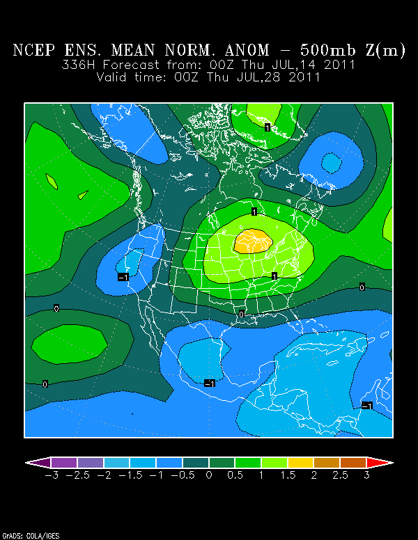
:uarrow: And supporting the operational GFS is the 0z GFS ensembles 500mb anomalies for the end for the end of July.

Looks like there is going to be a lot of unsettled weather in the Caribbean.

Image
0 likes   
The following post is NOT an official forecast and should not be used as such. It is just the opinion of the poster and may or may not be backed by sound meteorological data. It is NOT endorsed by any professional institution including storm2k.org For Official Information please refer to the NHC and NWS products.

User avatar
ROCK
Category 5
Category 5
Posts: 9484
Age: 54
Joined: Tue Aug 17, 2004 7:30 am
Location: Kemah, Texas

Re: Global Model Runs Discussion

#2250 Postby ROCK » Thu Jul 14, 2011 9:24 pm

Ivanhater wrote:
South Texas Storms wrote::uarrow:
Ivan do you think the activity will start to ramp up towards the end of the month?


I think all the signs are pointing to yes.


I totally agree Ivan....its going to get nasty in a few weeks....look at the heat potential out there....


http://wxmaps.org/pix/hurpot.html#ATL
0 likes   

User avatar
cycloneye
Admin
Admin
Posts: 145309
Age: 68
Joined: Thu Oct 10, 2002 10:54 am
Location: San Juan, Puerto Rico

Re: Global Model Runs Discussion

#2251 Postby cycloneye » Fri Jul 15, 2011 2:08 pm

12z ECMWF develops into a strong storm/hurricane in the EPAC.

Image

Same as CMC:

Image

GFS also develops,but at a sooner pace than the other two.

Image
0 likes   
Visit the Caribbean-Central America Weather Thread where you can find at first post web cams,radars
and observations from Caribbean basin members Click Here

plasticup

#2252 Postby plasticup » Fri Jul 15, 2011 3:32 pm

Is that Atlantic ridge still present in the long-run models? It has been really persistent so far this year.
0 likes   

User avatar
Rgv20
S2K Supporter
S2K Supporter
Posts: 2466
Age: 38
Joined: Wed Jan 05, 2011 5:42 pm
Location: Edinburg/McAllen Tx

#2253 Postby Rgv20 » Fri Jul 15, 2011 8:09 pm

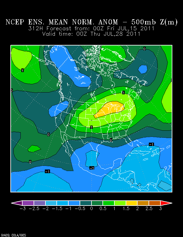
0z GFS Ensembles are still persistent in lowering the 500mb heights by the end of July in the Caribbean, meaning a lot of unsettled weather down there.

Image


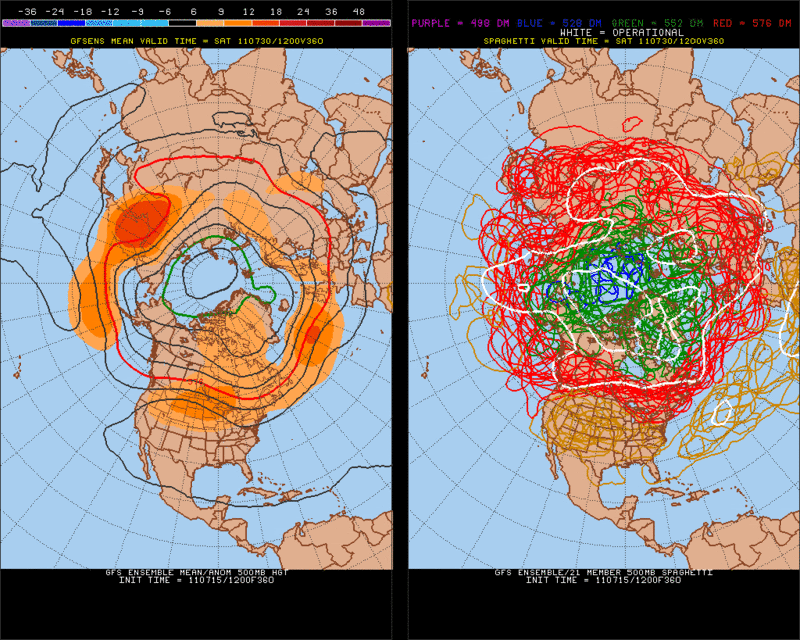
12z GFS Ensembles forecast above normal 500mb heights over the northern US and southern Canada by the end of the month which, means no recurve if an early season CV storm were to form. If this pattern were to persist until early August, the Caribbean and the US coast would be at an elevated risk to be affected by a TC.

Image
0 likes   
The following post is NOT an official forecast and should not be used as such. It is just the opinion of the poster and may or may not be backed by sound meteorological data. It is NOT endorsed by any professional institution including storm2k.org For Official Information please refer to the NHC and NWS products.

User avatar
Ptarmigan
Category 5
Category 5
Posts: 5313
Joined: Wed Aug 16, 2006 9:06 pm

Re: Global Model Runs Discussion

#2254 Postby Ptarmigan » Fri Jul 15, 2011 9:14 pm

ROCK wrote:
Ivanhater wrote:
South Texas Storms wrote::uarrow:
Ivan do you think the activity will start to ramp up towards the end of the month?


I think all the signs are pointing to yes.


I totally agree Ivan....its going to get nasty in a few weeks....look at the heat potential out there....


http://wxmaps.org/pix/hurpot.html#ATL


August is usually when it becomes active for the Atlantic Basin. Nice to get more rain regardless. :wink:
0 likes   

User avatar
Rgv20
S2K Supporter
S2K Supporter
Posts: 2466
Age: 38
Joined: Wed Jan 05, 2011 5:42 pm
Location: Edinburg/McAllen Tx

#2255 Postby Rgv20 » Fri Jul 15, 2011 9:18 pm

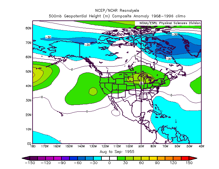
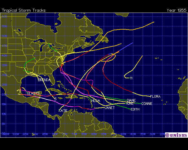
1955 had a similar 500mb pattern in August and September as what the GFS is hinting at the end of the month to start August.

Image
Image


Just two of these were in October (#11 & Katie) the rest of the TC occur from the end of July to September.

Image
0 likes   
The following post is NOT an official forecast and should not be used as such. It is just the opinion of the poster and may or may not be backed by sound meteorological data. It is NOT endorsed by any professional institution including storm2k.org For Official Information please refer to the NHC and NWS products.

dwsqos2

Re: Global Model Runs Discussion

#2256 Postby dwsqos2 » Fri Jul 15, 2011 11:56 pm

The 0z gfs still looks soporific.
0 likes   

User avatar
cycloneye
Admin
Admin
Posts: 145309
Age: 68
Joined: Thu Oct 10, 2002 10:54 am
Location: San Juan, Puerto Rico

Re: Global Model Runs Discussion

#2257 Postby cycloneye » Sun Jul 17, 2011 6:08 am

Still nothing significant on the models about tropical developments between Africa and the Lesser Antilles,but that could change soon as the CV season draws closer.
0 likes   
Visit the Caribbean-Central America Weather Thread where you can find at first post web cams,radars
and observations from Caribbean basin members Click Here

User avatar
NDG
S2K Supporter
S2K Supporter
Posts: 15446
Joined: Sun Jul 09, 2006 10:14 pm
Location: Orlando, FL

#2258 Postby NDG » Sun Jul 17, 2011 8:54 am

Last night's Euro shows a strong tropical wave to track across the Atlantic, straight towards the northern Caribbean Islands.
Most important that it shows is an expanding westward moving Atlantic mid level ridge, I have not seen that this season yet.
GFS also shows the sypnotic set up.

http://www.meteo.psu.edu/~gadomski/ECMWFTROPATL_0z/ecmwfloop.html
0 likes   

User avatar
BigA
Professional-Met
Professional-Met
Posts: 1317
Joined: Sun Jul 24, 2005 10:56 pm

Re: Global Model Runs Discussion

#2259 Postby BigA » Sun Jul 17, 2011 2:10 pm

NDG wrote:Last night's Euro shows a strong tropical wave to track across the Atlantic, straight towards the northern Caribbean Islands.
Most important that it shows is an expanding westward moving Atlantic mid level ridge, I have not seen that this season yet.
GFS also shows the sypnotic set up.

http://www.meteo.psu.edu/~gadomski/ECMWFTROPATL_0z/ecmwfloop.html


Today's Euro shows that same wave becoming a tropical storm in the 9-10 day period in the Gulf of Mexico.
0 likes   

User avatar
Ivanhater
Storm2k Moderator
Storm2k Moderator
Posts: 11161
Age: 38
Joined: Fri Jul 01, 2005 8:25 am
Location: Pensacola

Re: Global Model Runs Discussion

#2260 Postby Ivanhater » Sun Jul 17, 2011 2:17 pm

12z Euro

[img]Image

Uploaded with ImageShack.us[/img]
0 likes   
Michael


Return to “2015”

Who is online

Users browsing this forum: No registered users and 2 guests