
Circulation showing up nicely on JAX radar. Seems to be a slow S-SW drift. This may be our next INVEST later today.
http://radar.weather.gov/radar.php?product=N0Z&rid=JAX&loop=yes
Development off SE Coast (Invest 98L)
Moderator: S2k Moderators
Forum rules

The posts in this forum are NOT official forecasts and should not be used as such. They are just the opinion of the poster and may or may not be backed by sound meteorological data. They are NOT endorsed by any professional institution or STORM2K. For official information, please refer to products from the National Hurricane Center and National Weather Service.
Re: Development off SE Coast
0 likes
Re: Development off SE Coast
ronjon wrote:Correct Larry - NW shear looks to be about 20-30 kts. That's going to have to relax plus it'll have to diconnect from the frontal boundary to get going toward a tropical depression. Still, it's in a favorable location and its that time of year. Not sure about future movement as models have been inconsistent - latest GFS wants to take it at least partially W-SW over the FL peninsula and then eventually back NE.
http://www.ssd.noaa.gov/goes/east/gmex/loop-vis.html
Ronjon,
Agreed. Whatever this does, it does appear to be headed in the general direction of FL on Mon.
Interestingly, there does appear to be a somewhat decently defined LLC that even the often false alarm NAM doesn't seem to be modeling too well. Just compare the 6z NAM's sim. radar at hour six, which is real messy looking, and the more organized looking actual radar from Jax.
0 likes
Personal Forecast Disclaimer:
The posts in this forum are NOT official forecasts and should not be used as such. They are just the opinion of the poster and may or may not be backed by sound meteorological data. They are NOT endorsed by any professional institution or storm2k.org. For official information, please refer to the NHC and NWS products.
The posts in this forum are NOT official forecasts and should not be used as such. They are just the opinion of the poster and may or may not be backed by sound meteorological data. They are NOT endorsed by any professional institution or storm2k.org. For official information, please refer to the NHC and NWS products.

-
northjaxpro

- S2K Supporter

- Posts: 8900
- Joined: Mon Sep 27, 2010 11:21 am
- Location: Jacksonville, FL
Re: Development off SE Coast
ronjon wrote:Circulation showing up nicely on JAX radar. Seems to be a slow S-SW drift. This may be our next INVEST later today.
http://radar.weather.gov/radar.php?product=N0Z&rid=JAX&loop=yes
Possibly, if the convection can continue to build or maintain itself near the circulation. If the shear can relax just a tad, we may have something indeed.
Also, for this entity to have a chance to truly organize, it has to detach itself from the frontal boundary as time progresses.
0 likes
NEVER, EVER SAY NEVER in the tropics and weather in general, and most importantly, with life itself!!
________________________________________________________________________________________
Fay 2008 Beryl 2012 Debby 2012 Colin 2016 Hermine 2016 Julia 2016 Matthew 2016 Irma 2017 Dorian 2019
________________________________________________________________________________________
Fay 2008 Beryl 2012 Debby 2012 Colin 2016 Hermine 2016 Julia 2016 Matthew 2016 Irma 2017 Dorian 2019
Re: Development off SE Coast
Starting to look organized on VIS SAT.
http://weather.rap.ucar.edu/satellite/displaySat.php?region=TPA&itype=vis&size=large&endDate=20100612&endTime=-1&duration=3
http://weather.rap.ucar.edu/satellite/displaySat.php?region=TPA&itype=vis&size=large&endDate=20100612&endTime=-1&duration=3
0 likes
Re: Development off SE Coast
ronjon wrote:Starting to look organized on VIS SAT.
http://weather.rap.ucar.edu/satellite/displaySat.php?region=TPA&itype=vis&size=large&endDate=20100612&endTime=-1&duration=3
It sure looks like to have a nice cyclonic circulation trying to get better organized, but I still think that it is not that well organzed yet at the surface.
Surface pressure if anything continue to go up this morning.
That vorticity must be at H925 or H85, upper level winds don't look that terrible. Regardless, surprised that it is not an Invest yet.
0 likes


Re:
BigA wrote:Upper level conditions appear to be improving, especially if it drifts southward. But I don't see anything that shows me a surface circulation right now.
KCHS thinks there is a weak sfc circ. although I don't follow the NAM comment:
AREA FORECAST DISCUSSION
NATIONAL WEATHER SERVICE CHARLESTON SC
1044 AM EDT SAT JUL 16 2011
A WEAK SURFACE LOW IS EVIDENT ON VISIBLE SATELLITE THIS MORNING OFF THE GA/FL COAST.
MODELS HAVE NOT INITIALIZED THIS FEATURE VERY WELL. THE NAM IS THE
ONLY MODEL THAT SHOWS A CLOSED LOW IN THE INITIAL CONDITIONS AND
IT TAKES THE LOW WEST INTO THE FLORIDA COAST TONIGHT.
0 likes
Personal Forecast Disclaimer:
The posts in this forum are NOT official forecasts and should not be used as such. They are just the opinion of the poster and may or may not be backed by sound meteorological data. They are NOT endorsed by any professional institution or storm2k.org. For official information, please refer to the NHC and NWS products.
The posts in this forum are NOT official forecasts and should not be used as such. They are just the opinion of the poster and may or may not be backed by sound meteorological data. They are NOT endorsed by any professional institution or storm2k.org. For official information, please refer to the NHC and NWS products.

Re: Development off SE Coast
The low formed right on the 30 N latitude line and has been drifting SSW best I can tell. Could die out once it gets over land unless the LLC reforms in the gulf.
0 likes
-
Aric Dunn
- Category 5

- Posts: 21238
- Age: 43
- Joined: Sun Sep 19, 2004 9:58 pm
- Location: Ready for the Chase.
- Contact:
Hey all... been awhile 
Surface reports do show a very weak surface low attached at the tail end of the stalled frontal boundary. the radar and satellite show a quite distinct mid level circ that is sliding ESE while the surface reflection is quite weak. but as usual we need some deep convection to maintain to get a strong surface circ. the upper dynamics bode well for deep convection to develop today and tonight and with a existing surface reflection in place it should not take long for a transitioning system to start to take shape. with the shear forecast to relax a little for the next couple days there is at least a 50/50 chance of something developing then being pushed back to the NE FL, GA coast; however it is possible for the mid level to drop farther SE and depending on where the deep convection develops, we could see the low level circ develop farther S sometime tomorrow. there is also the potential for a second system develop farther east along the old boundary.
Surface reports do show a very weak surface low attached at the tail end of the stalled frontal boundary. the radar and satellite show a quite distinct mid level circ that is sliding ESE while the surface reflection is quite weak. but as usual we need some deep convection to maintain to get a strong surface circ. the upper dynamics bode well for deep convection to develop today and tonight and with a existing surface reflection in place it should not take long for a transitioning system to start to take shape. with the shear forecast to relax a little for the next couple days there is at least a 50/50 chance of something developing then being pushed back to the NE FL, GA coast; however it is possible for the mid level to drop farther SE and depending on where the deep convection develops, we could see the low level circ develop farther S sometime tomorrow. there is also the potential for a second system develop farther east along the old boundary.
0 likes
Note: If I make a post that is brief. Please refer back to previous posts for the analysis or reasoning. I do not re-write/qoute what my initial post said each time.
If there is nothing before... then just ask
Space & Atmospheric Physicist, Embry-Riddle Aeronautical University,
I believe the sky is falling...
If there is nothing before... then just ask
Space & Atmospheric Physicist, Embry-Riddle Aeronautical University,
I believe the sky is falling...
Re: Development off SE Coast
Appears to be a twist to a cut-off Low hanging by the Florida Alabama border.
0 likes
-
Rgv20

- S2K Supporter
- Posts: 2466
- Age: 39
- Joined: Wed Jan 05, 2011 5:42 pm
- Location: Edinburg/McAllen Tx
NWS Brownsville morning discussion.
A RATHER WEAK LOW...SPINNING NEAR THE FLORIDA BIG BEND...IS FORECAST
TO START MIGRATING WESTWARD SUNDAY.
LONG TERM /SUNDAY NIGHT THROUGH FRIDAY/...
THE LONG TERM FORECAST PERIOD WILL CONTINUE TO BE DOMINATED
OVERALL BY HIGH PRESSURE AT THE SFC AND ALOFT. THE ONLY CAVEAT
WILL BE THE AFOREMENTIONED WEAK LOW FROM THE SHORT TERM DISCUSSION
WILL BE MAKING PROGRESS TWD THE TX COAST EARLY IN THE WEEK CROSSING
THRU SOUTH TX AROUND TUESDAY. THIS FEATURE WILL BEGIN TO BRING OUR
RAIN CHANCES UP SLIGHTLY MON THRU WED. THE BEST DAY FOR SHOWERS
AND OR ISOLATED TSTMS WILL BE TUE....
It certainly looks messy out there.
0 likes
The following post is NOT an official forecast and should not be used as such. It is just the opinion of the poster and may or may not be backed by sound meteorological data. It is NOT endorsed by any professional institution including storm2k.org For Official Information please refer to the NHC and NWS products.
-
Aric Dunn
- Category 5
- Posts: 21238
- Age: 43
- Joined: Sun Sep 19, 2004 9:58 pm
- Location: Ready for the Chase.
- Contact:
Re:
Rgv20 wrote:NWS Brownsville morning discussion.
A RATHER WEAK LOW...SPINNING NEAR THE FLORIDA BIG BEND...IS FORECAST
TO START MIGRATING WESTWARD SUNDAY.
LONG TERM /SUNDAY NIGHT THROUGH FRIDAY/...
THE LONG TERM FORECAST PERIOD WILL CONTINUE TO BE DOMINATED
OVERALL BY HIGH PRESSURE AT THE SFC AND ALOFT. THE ONLY CAVEAT
WILL BE THE AFOREMENTIONED WEAK LOW FROM THE SHORT TERM DISCUSSION
WILL BE MAKING PROGRESS TWD THE TX COAST EARLY IN THE WEEK CROSSING
THRU SOUTH TX AROUND TUESDAY. THIS FEATURE WILL BEGIN TO BRING OUR
RAIN CHANCES UP SLIGHTLY MON THRU WED. THE BEST DAY FOR SHOWERS
AND OR ISOLATED TSTMS WILL BE TUE....
It certainly looks messy out there.
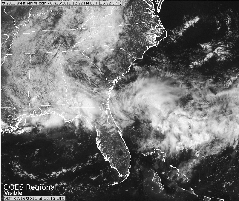
[img]http://i61.photobucket.com/albums/h62/cantu5977/WeatherTAPcom-SoutheasternUSVisibleSatellite2011-07-1611-35-26.png[/img
thats funny.. the 12z GFS takes the LOW out to see ENE then NE :p
http://mag.ncep.noaa.gov/NCOMAGWEB/appc ... mageSize=M
0 likes
Note: If I make a post that is brief. Please refer back to previous posts for the analysis or reasoning. I do not re-write/qoute what my initial post said each time.
If there is nothing before... then just ask
Space & Atmospheric Physicist, Embry-Riddle Aeronautical University,
I believe the sky is falling...
If there is nothing before... then just ask
Space & Atmospheric Physicist, Embry-Riddle Aeronautical University,
I believe the sky is falling...
-
Dean4Storms
- S2K Supporter
- Posts: 6358
- Age: 62
- Joined: Sun Aug 31, 2003 1:01 pm
- Location: Miramar Bch. FL
Re: Re:
Aric Dunn wrote:Rgv20 wrote:NWS Brownsville morning discussion.
A RATHER WEAK LOW...SPINNING NEAR THE FLORIDA BIG BEND...IS FORECAST
TO START MIGRATING WESTWARD SUNDAY.
LONG TERM /SUNDAY NIGHT THROUGH FRIDAY/...
THE LONG TERM FORECAST PERIOD WILL CONTINUE TO BE DOMINATED
OVERALL BY HIGH PRESSURE AT THE SFC AND ALOFT. THE ONLY CAVEAT
WILL BE THE AFOREMENTIONED WEAK LOW FROM THE SHORT TERM DISCUSSION
WILL BE MAKING PROGRESS TWD THE TX COAST EARLY IN THE WEEK CROSSING
THRU SOUTH TX AROUND TUESDAY. THIS FEATURE WILL BEGIN TO BRING OUR
RAIN CHANCES UP SLIGHTLY MON THRU WED. THE BEST DAY FOR SHOWERS
AND OR ISOLATED TSTMS WILL BE TUE....
It certainly looks messy out there.
[img]http://i61.photobucket.com/albums/h62/cantu5977/WeatherTAPcom-SoutheasternUSVisibleSatellite2011-07-1611-35-26.png[/img
thats funny.. the 12z GFS takes the LOW out to see ENE then NE :p
http://mag.ncep.noaa.gov/NCOMAGWEB/appc ... mageSize=M
There are two different areas of low pressure. One currently over extreme south AL drifting WSW that is expected to move along the Gulf Coast toward LA/TX border and then there is the MCS which might have a surface reflection off the NE FL coast both along this trough boundary. Looks like the GFS sends the one off the NE FL coast out to sea and the AL Low westward along the Gulf Coast.
0 likes
-
Aric Dunn
- Category 5
- Posts: 21238
- Age: 43
- Joined: Sun Sep 19, 2004 9:58 pm
- Location: Ready for the Chase.
- Contact:
Re: Re:
Dean4Storms wrote:Aric Dunn wrote:Rgv20 wrote:NWS Brownsville morning discussion.
A RATHER WEAK LOW...SPINNING NEAR THE FLORIDA BIG BEND...IS FORECAST
TO START MIGRATING WESTWARD SUNDAY.
LONG TERM /SUNDAY NIGHT THROUGH FRIDAY/...
THE LONG TERM FORECAST PERIOD WILL CONTINUE TO BE DOMINATED
OVERALL BY HIGH PRESSURE AT THE SFC AND ALOFT. THE ONLY CAVEAT
WILL BE THE AFOREMENTIONED WEAK LOW FROM THE SHORT TERM DISCUSSION
WILL BE MAKING PROGRESS TWD THE TX COAST EARLY IN THE WEEK CROSSING
THRU SOUTH TX AROUND TUESDAY. THIS FEATURE WILL BEGIN TO BRING OUR
RAIN CHANCES UP SLIGHTLY MON THRU WED. THE BEST DAY FOR SHOWERS
AND OR ISOLATED TSTMS WILL BE TUE....
It certainly looks messy out there.
[img]http://i61.photobucket.com/albums/h62/cantu5977/WeatherTAPcom-SoutheasternUSVisibleSatellite2011-07-1611-35-26.png[/img
thats funny.. the 12z GFS takes the LOW out to see ENE then NE :p
http://mag.ncep.noaa.gov/NCOMAGWEB/appc ... mageSize=M
There are two different areas of low pressure. One currently over extreme south AL drifting WSW that is expected to move along the Gulf Coast toward LA/TX border and then there is the MCS which might have a surface reflection off the NE FL coast both along this trough boundary. Looks like the GFS sends the one off the NE FL coast out to sea and the AL Low westward along the Gulf Coast.
oh I apologize. I thought I read something different.
0 likes
Note: If I make a post that is brief. Please refer back to previous posts for the analysis or reasoning. I do not re-write/qoute what my initial post said each time.
If there is nothing before... then just ask
Space & Atmospheric Physicist, Embry-Riddle Aeronautical University,
I believe the sky is falling...
If there is nothing before... then just ask
Space & Atmospheric Physicist, Embry-Riddle Aeronautical University,
I believe the sky is falling...
-
cycloneye

- Admin

- Posts: 148732
- Age: 69
- Joined: Thu Oct 10, 2002 10:54 am
- Location: San Juan, Puerto Rico
Re: Development off SE Coast
The squadron is ready to fly if needed starting on Sunday afternoon.
Code: Select all
000
NOUS42 KNHC 161715
WEATHER RECONNAISSANCE FLIGHTS
CARCAH, NATIONAL HURRICANE CENTER, MIAMI, FL.
115 PM EDT SAT 16 JULY 2011
SUBJECT: TROPICAL CYCLONE PLAN OF THE DAY (TCPOD)
         VALID 17/1100Z TO 18/1100Z JULY 2011
         TCPOD NUMBER.....11-046

I.  ATLANTIC REQUIREMENTS
    1. SUSPECT AREA
       FLIGHT ONE -- TEAL 70
       A. 17/1800Z
       B. AFXXX 01BBA INVEST
       C. 17/1615Z
       D. 29.2N 78.6W
       E. 17/1815Z TO 17/2345Z
       F. SFC TO 10,000 FT

       FLIGHT TWO -- TEAL 71
       A. 18/0600
       B. AFXXX 0202A CYCLONE
       C. 18/0300Z
       D. 29.0N 78.5W
       E. 18/0500Z TO 18/0900Z
       F. SFC TO 10,000 FT

    2. OUTLOOK FOR SUCCEEDING DAY: CONTINUE 12-HRLY
       FIXES WHILE SYSTEM REMAINS A THREAT.
0 likes
Visit the Caribbean-Central America Weather Thread where you can find at first post web cams,radars
and observations from Caribbean basin members Click Here
and observations from Caribbean basin members Click Here
-
Aric Dunn
- Category 5
- Posts: 21238
- Age: 43
- Joined: Sun Sep 19, 2004 9:58 pm
- Location: Ready for the Chase.
- Contact:
0 likes
Note: If I make a post that is brief. Please refer back to previous posts for the analysis or reasoning. I do not re-write/qoute what my initial post said each time.
If there is nothing before... then just ask
Space & Atmospheric Physicist, Embry-Riddle Aeronautical University,
I believe the sky is falling...
If there is nothing before... then just ask
Space & Atmospheric Physicist, Embry-Riddle Aeronautical University,
I believe the sky is falling...
-
Ivanhater

- Storm2k Moderator

- Posts: 11166
- Age: 39
- Joined: Fri Jul 01, 2005 8:25 am
- Location: Pensacola
Re: Development off SE Coast
Now Invest 98L
Off of Jacksonville:
BEGIN
NHC_ATCF
invest_al982011.invest
FSTDA
R
U
040
010
0000
201107161734
NONE
NOTIFY=ATRP
END
INVEST, AL, L, , , , , 98, 2011, DB, O, 2011071618, 9999999999, , , , , , METWATCH, , AL982011
AL, 98, 2011071518, , BEST, 0, 313N, 804W, 20, 1015, DB, 0, , 0, 0, 0, 0,
AL, 98, 2011071600, , BEST, 0, 310N, 800W, 20, 1015, DB, 0, , 0, 0, 0, 0,
AL, 98, 2011071606, , BEST, 0, 307N, 797W, 20, 1014, DB, 0, , 0, 0, 0, 0,
AL, 98, 2011071612, , BEST, 0, 304N, 794W, 20, 1014, DB, 0, , 0, 0, 0, 0,
AL, 98, 2011071618, , BEST, 0, 300N, 791W, 20, 1014, DB, 34, NEQ, 0, 0, 0, 0, 1016, 175, 90, 0, 0, L, 0, , 0, 0, INVEST, S,
Discuss here
viewtopic.php?f=59&t=111181&st=0&sk=t&sd=a&start=60
0 likes
Michael
Who is online
Users browsing this forum: cycloneye and 69 guests