ATL: BRET - Remnants - Discussion

Moderator: S2k Moderators

Message
Author
User avatar
Rgv20
S2K Supporter
S2K Supporter
Posts: 2466
Age: 38
Joined: Wed Jan 05, 2011 5:42 pm
Location: Edinburg/McAllen Tx

#201 Postby Rgv20 » Sun Jul 17, 2011 11:52 am

The 0z forecast steering by Monday afternoon would suggest a slow NNE movement.

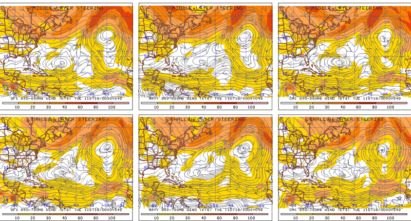
This is the forecast steering map for a TD or TS as indicated by the GFS, NOGAPS, and CMC.

Image
0 likes   
The following post is NOT an official forecast and should not be used as such. It is just the opinion of the poster and may or may not be backed by sound meteorological data. It is NOT endorsed by any professional institution including storm2k.org For Official Information please refer to the NHC and NWS products.

User avatar
northjaxpro
S2K Supporter
S2K Supporter
Posts: 8900
Joined: Mon Sep 27, 2010 11:21 am
Location: Jacksonville, FL

Re:

#202 Postby northjaxpro » Sun Jul 17, 2011 11:52 am

gatorcane wrote:Only thing to watch is the big 500MB ridge currently in the center of the United States. That ridge is bringing the big heat wave that we are hearing about.

That looks like it is sliding to the east. I wonder if 98L meanders enought it will get blocked as the ridge shifts over to the MidAtlantic. Thoughts?

WV loop:
http://www.ssd.noaa.gov/goes/east/eaus/loop-wv.html

500MB heights from 06Z GFS:

Image


That is a possibility. So many variables to weigh. You have to weigh how strong 98L will be in 48 hours or so. It the system stays a TD or weak TS at best, then it is likely that it will not feel the effects of the trough that is currently in place to pull it out to sea. If the massive High over the Central U.S. does build eastward to the Mid Atlantic by Wednesday, it could indeed block the system from moving out to the north or northeast. It is possible that 98L may linger off the coast for several days. Lots of possiblities. We will hopefully get more in the details once Recon gets in there shortly and the data they collect will be incorporated into future model runs.
0 likes   
NEVER, EVER SAY NEVER in the tropics and weather in general, and most importantly, with life itself!!

________________________________________________________________________________________

Fay 2008 Beryl 2012 Debby 2012 Colin 2016 Hermine 2016 Julia 2016 Matthew 2016 Irma 2017 Dorian 2019

User avatar
cycloneye
Admin
Admin
Posts: 145295
Age: 68
Joined: Thu Oct 10, 2002 10:54 am
Location: San Juan, Puerto Rico

Re: ATL: INVEST 98L - Recon

#203 Postby cycloneye » Sun Jul 17, 2011 11:57 am

Mike,so far I haven't seen the HDOB's.
0 likes   
Visit the Caribbean-Central America Weather Thread where you can find at first post web cams,radars
and observations from Caribbean basin members Click Here

User avatar
PTrackerLA
Category 5
Category 5
Posts: 5277
Age: 41
Joined: Thu Oct 10, 2002 8:40 pm
Location: Lafayette, LA

Re: ATL: INVEST 98L - Discussion

#204 Postby PTrackerLA » Sun Jul 17, 2011 11:58 am

Very interesting feature here, definitely think we'll see an upgrade to at least a TD this afternoon. If it were to cross into the gulf hopefully it will continue our recent trend of higher rain chances without misbehaving too bad!
0 likes   

User avatar
ROCK
Category 5
Category 5
Posts: 9484
Age: 54
Joined: Tue Aug 17, 2004 7:30 am
Location: Kemah, Texas

Re: ATL: INVEST 98L - Discussion

#205 Postby ROCK » Sun Jul 17, 2011 12:02 pm

Looks good and should continue to developed. Looks like a TS already...wonder if Nhc upgrade directly to Bret...
0 likes   

User avatar
senorpepr
Military Met/Moderator
Posts: 12542
Age: 43
Joined: Fri Aug 22, 2003 9:22 pm
Location: Mackenbach, Germany
Contact:

Re: ATL: INVEST 98L - Recon

#206 Postby senorpepr » Sun Jul 17, 2011 12:03 pm

cycloneye wrote:Mike,so far I haven't seen the HDOB's.


Me either... Hopefully that functionality will return as they near the system.
0 likes   

Frank2
Category 5
Category 5
Posts: 4061
Joined: Mon Jul 25, 2005 12:47 pm

Re: ATL: INVEST 98L - Discussion

#207 Postby Frank2 » Sun Jul 17, 2011 12:03 pm

Last few photos some increase in organization - we'll see what happens, and though the SHIPS indicates it might come this way, the VIS loop seems to show an eastward drift at this time...

Frank
0 likes   

User avatar
fci
S2K Supporter
S2K Supporter
Posts: 3324
Joined: Tue Sep 14, 2004 10:29 am
Location: Lake Worth, FL

#208 Postby fci » Sun Jul 17, 2011 12:09 pm

I hold no faith in SHIPS.
This is destined to eventually move NE.
Just hope that it gets close enough to us in FL to give us much needed rain.

Personal Forecast Disclaimer:
The posts in this forum are NOT official forecast and should not be used as such. They are just the opinion of the poster and may or may not be backed by sound meteorological data. They are NOT endorsed by any professional institution or storm2k.org. For official information, please refer to the NHC and NWS products.
0 likes   

User avatar
KatDaddy
Category 5
Category 5
Posts: 2815
Joined: Mon Oct 21, 2002 6:23 pm
Location: League City, Texas

Re: ATL: INVEST 98L - Discussion

#209 Postby KatDaddy » Sun Jul 17, 2011 12:10 pm

I expect an upgrade to TD very soon. Look good on satellite. I would sure like this system move across FLA and give TX rainfall but must be very careful what you ask for.
0 likes   
The following post is NOT an official forecast and should not be used as such. It is just the opinion of the poster and may or may not be backed by sound meteorological data. It is NOT endorsed by any professional institution including storm2k.org For Official Information please refer to the NHC and NWS products.

User avatar
Vortex
S2K Supporter
S2K Supporter
Posts: 4644
Age: 53
Joined: Fri Aug 01, 2003 9:34 pm
Location: Hilton Head, SC

#210 Postby Vortex » Sun Jul 17, 2011 12:10 pm

per the 12:55 utc...wrapping up nicely...Im going with TD by 5pm....TS looks reasonable...West Palm to Melbourned best guess before it rides the coast N the NE possible impacting the carolinas...Just a best "guess" at this point...
0 likes   

User avatar
Dave
Retired Staff
Retired Staff
Posts: 13442
Age: 74
Joined: Tue Aug 01, 2006 3:57 pm
Location: Milan Indiana
Contact:

#211 Postby Dave » Sun Jul 17, 2011 12:10 pm

000
URNT15 KBIX 141239
AF303 WXWXA 110713223312303 HDOB 07 20110713
233400 2809N 08715W 3991 07615 0416 -160 -192 078014 015 /// /// 03
233430 2808N 08712W 3992 07615 0417 -160 -192 081015 016 /// /// 03
233500 2808N 08710W 3991 07618 0417 -161 -191 083013 014 /// /// 03
233530 2807N 08708W 3991 07616 0417 -163 -192 089012 012 /// /// 03
233600 2806N 08705W 3992 07616 0417 -162 -192 095011 012 /// /// 03
233630 2806N 08703W 3992 07615 0417 -160 -192 082012 013 /// /// 03
233700 2805N 08700W 3991 07620 0418 -160 -193 093012 013 /// /// 03
233730 2804N 08658W 3991 07619 0420 -164 -193 105011 011 /// /// 03
233800 2804N 08656W 3990 07622 0422 -162 -194 099010 010 /// /// 03
233830 2803N 08653W 3991 07621 0423 -164 -195 094008 008 /// /// 03
233900 2802N 08651W 3992 07620 0423 -165 -195 087009 010 /// /// 03
233930 2801N 08648W 3994 07605 0413 -163 -197 095009 010 /// /// 03
234000 2801N 08646W 3995 07615 0418 -162 -198 093009 010 /// /// 03
234030 2800N 08644W 3992 07609 0411 -165 -198 096009 010 /// /// 03
234100 2759N 08641W 3991 07611 0412 -163 -199 096009 010 /// /// 03
234130 2759N 08639W 3994 07607 0413 -160 -200 105009 010 /// /// 03
234200 2758N 08636W 3995 07607 0413 -160 -201 105011 011 /// /// 03
234230 2757N 08634W 3995 07604 0412 -160 -202 104012 013 /// /// 03
234300 2756N 08632W 3995 07605 0413 -160 -203 109013 014 /// /// 03
234330 2756N 08629W 3995 07605 0412 -160 -204 104012 013 /// /// 03
$$
;
0 likes   

User avatar
Vortex
S2K Supporter
S2K Supporter
Posts: 4644
Age: 53
Joined: Fri Aug 01, 2003 9:34 pm
Location: Hilton Head, SC

#212 Postby Vortex » Sun Jul 17, 2011 12:13 pm

Appears to be drifting S over the last 3 hours...
0 likes   

User avatar
Blown Away
S2K Supporter
S2K Supporter
Posts: 10145
Joined: Wed May 26, 2004 6:17 am

Re: ATL: INVEST 98L - Discussion

#213 Postby Blown Away » Sun Jul 17, 2011 12:13 pm

Looks like dry air being pulled in towards the center.
0 likes   
Hurricane Eye Experience: David 79, Irene 99, Frances 04, Jeanne 04, Wilma 05... EYE COMING MY WAY IN 2024…
Hurricane Brush Experience: Andrew 92, Erin 95, Floyd 99, Matthew 16, Irma 17, Ian 22, Nicole 22…

User avatar
AdamFirst
S2K Supporter
S2K Supporter
Posts: 2491
Age: 36
Joined: Thu Aug 14, 2008 10:54 am
Location: Port Saint Lucie, FL

Re: ATL: INVEST 98L - Discussion

#214 Postby AdamFirst » Sun Jul 17, 2011 12:14 pm

The Melbourne long range radar still suggests a general southward crawl.
0 likes   
Dolphins Marlins Canes Golden Panthers HEAT
Andrew 1992 - Irene 1999 - Frances 2004 - Jeanne 2004 - Wilma 2005 - Fay 2008 - Isaac 2012 - Matthew 2016 - Irma 2017 - Dorian 2019 - Ian 2022 - Nicole 2022 - Milton 2024

User avatar
Blown Away
S2K Supporter
S2K Supporter
Posts: 10145
Joined: Wed May 26, 2004 6:17 am

Re:

#215 Postby Blown Away » Sun Jul 17, 2011 12:14 pm

Vortex wrote:Appears to be drifting S over the last 3 hours...


It's been hugging that 28/78 crosshair for hours.
0 likes   
Hurricane Eye Experience: David 79, Irene 99, Frances 04, Jeanne 04, Wilma 05... EYE COMING MY WAY IN 2024…
Hurricane Brush Experience: Andrew 92, Erin 95, Floyd 99, Matthew 16, Irma 17, Ian 22, Nicole 22…

User avatar
Dave
Retired Staff
Retired Staff
Posts: 13442
Age: 74
Joined: Tue Aug 01, 2006 3:57 pm
Location: Milan Indiana
Contact:

#216 Postby Dave » Sun Jul 17, 2011 12:16 pm

Looks like 2 planes in the air...sorting them out now.
0 likes   

User avatar
Ivanhater
Storm2k Moderator
Storm2k Moderator
Posts: 11160
Age: 38
Joined: Fri Jul 01, 2005 8:25 am
Location: Pensacola

Re: ATL: INVEST 98L - Discussion

#217 Postby Ivanhater » Sun Jul 17, 2011 12:17 pm

Looking good!

Image
0 likes   
Michael

User avatar
senorpepr
Military Met/Moderator
Posts: 12542
Age: 43
Joined: Fri Aug 22, 2003 9:22 pm
Location: Mackenbach, Germany
Contact:

#218 Postby senorpepr » Sun Jul 17, 2011 12:18 pm

The scheduled mission is AF304 01BBA:


URNT15 KNHC 171713
AF304 01BBA INVEST HDOB 09 20110717
170230 2806N 08521W 3759 08082 0462 -196 //// 039015 016 /// /// 05
170300 2806N 08518W 3758 08082 0462 -194 //// 038011 012 /// /// 05
170330 2807N 08515W 3766 08070 0461 -191 //// 345009 012 /// /// 05
170400 2807N 08513W 3755 08093 0464 -193 //// 219001 004 /// /// 05
170430 2807N 08510W 3752 08095 0462 -192 //// 015008 015 /// /// 05
170500 2807N 08507W 3760 08080 0462 -200 //// 043012 012 /// /// 05
170530 2807N 08504W 3760 08080 0461 -200 //// 036012 012 /// /// 05
170600 2807N 08501W 3758 08084 0462 -199 //// 034012 013 /// /// 05
170630 2807N 08459W 3761 08078 0461 -200 //// 041011 011 /// /// 05
170700 2807N 08456W 3758 08080 0459 -200 //// 037011 012 /// /// 05
170730 2807N 08453W 3758 08079 0457 -200 //// 030010 011 /// /// 05
170800 2807N 08450W 3759 08078 0457 -199 //// 029008 009 /// /// 05
170830 2807N 08448W 3759 08078 0457 -200 //// 032009 010 /// /// 05
170900 2807N 08445W 3758 08079 0458 -200 //// 041010 010 /// /// 05
170930 2807N 08442W 3759 08078 0458 -200 //// 040010 010 /// /// 05
171000 2807N 08439W 3758 08080 0458 -200 //// 034010 010 /// /// 05
171030 2807N 08437W 3759 08079 0458 -200 //// 033010 010 /// /// 05
171100 2807N 08434W 3761 08075 0458 -200 //// 027011 011 /// /// 05
171130 2807N 08431W 3759 08078 0458 -200 //// 037010 010 /// /// 05
171200 2807N 08428W 3759 08078 0458 -200 //// 026009 009 /// /// 05
$$
0 likes   

User avatar
Bocadude85
Category 5
Category 5
Posts: 2991
Age: 38
Joined: Mon Apr 18, 2005 2:20 pm
Location: Honolulu,Hi

Re: Re:

#219 Postby Bocadude85 » Sun Jul 17, 2011 12:19 pm

Blown Away wrote:
Vortex wrote:Appears to be drifting S over the last 3 hours...


It's been hugging that 28/78 crosshair for hours.


Looking at the long range radar out of Melbourne I see a slow southward drift
0 likes   

jinftl
Category 5
Category 5
Posts: 4312
Joined: Tue Aug 31, 2004 4:47 pm
Location: fort lauderdale, fl

Re: ATL: INVEST 98L - Discussion

#220 Postby jinftl » Sun Jul 17, 2011 12:20 pm

If I didn't know we were talking about Invest 98, I would have to say, this looks like a td or ts...whether it has that level of organization will soon be known thanks to recon.

Ivanhater wrote:Looking good!
0 likes   


Return to “2011”

Who is online

Users browsing this forum: No registered users and 2 guests