Global model runs discussion
Moderator: S2k Moderators

Re: Global Model Runs Discussion
EURO looks interesting...funny how I cant see that on the EURO site but it comes up on Allen's...
0 likes
-
Rgv20

- S2K Supporter

- Posts: 2466
- Age: 39
- Joined: Wed Jan 05, 2011 5:42 pm
- Location: Edinburg/McAllen Tx
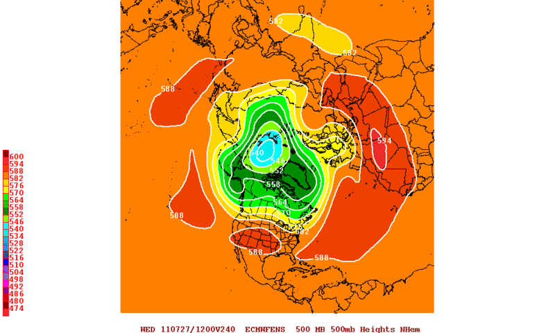
It still looks like the pattern for the end of July to start August would favor development in the Atlantic and Caribbean. The ECMWF and GFS Ensembles forecast for the Ridge to lift northward thus allowing the ITCZ to lift northward too. It's not a guaranteed that something would form but the pattern would suggest it.
This is the ECMWF Ensembles 500mb Height 10 days from now.
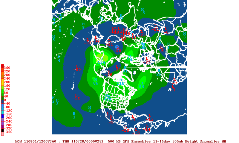
GFS Ensembles 500mb Height Anomalies 11 thru 15 days from now. All that blue color you see on the Atlantic and Caribbean is the lowering of 500mb height the cause being release of heat by showers and Thunder Storms.
This is the ECMWF Ensembles 500mb Height 10 days from now.
GFS Ensembles 500mb Height Anomalies 11 thru 15 days from now. All that blue color you see on the Atlantic and Caribbean is the lowering of 500mb height the cause being release of heat by showers and Thunder Storms.
0 likes
The following post is NOT an official forecast and should not be used as such. It is just the opinion of the poster and may or may not be backed by sound meteorological data. It is NOT endorsed by any professional institution including storm2k.org For Official Information please refer to the NHC and NWS products.

00z ECM develops a system again, clearly from a CV wave, probably the one thats exiting from Africa now, develops a closed circulation near the Bahamas then lifts northwards.
Its the same system as yesterdays 12z run but just a little more advanced in terms of development and so it heads north quicker.
Its the same system as yesterdays 12z run but just a little more advanced in terms of development and so it heads north quicker.
0 likes
Personal Forecast Disclaimer:
The posts in this forum are NOT official forecast and should not be used as such. They are just the opinion of the poster and may or may not be backed by sound meteorological data. They are NOT endorsed by any professional institution or storm2k.org. For official information, please refer to the NHC and NWS products
The posts in this forum are NOT official forecast and should not be used as such. They are just the opinion of the poster and may or may not be backed by sound meteorological data. They are NOT endorsed by any professional institution or storm2k.org. For official information, please refer to the NHC and NWS products

Re: Global Model Runs Discussion
00Z GFS, Euro, & FIM showing something passing thru the Leewards in 144 hrs.
Nice high-amp wave coming off Africa with a good moisture column.


Nice high-amp wave coming off Africa with a good moisture column.
0 likes


-
HURRICANELONNY
- Category 5

- Posts: 1392
- Joined: Wed May 07, 2003 6:48 am
- Location: HOLLYWOOD.FL
Re: Global Model Runs Discussion
Must agree. CV season might be starting a little early. 
0 likes
hurricanelonny
-
Hurricaneman

- Category 5
- Posts: 7404
- Age: 45
- Joined: Tue Aug 31, 2004 3:24 pm
- Location: central florida
Re: Global Model Runs Discussion
the last season where there was an early cape verde system was 2008, and people around houston know what happened in 2008
0 likes
Re: Global Model Runs Discussion
12Z CMC spinning it up in 36 hrs, around 15N 33W, as a borderline warm-core with relatively high surface-pressure.

0 likes
-
Texas Snowman

- Storm2k Moderator

- Posts: 6197
- Joined: Fri Jan 25, 2008 11:29 am
- Location: Denison, Texas
Lots of talk around North Texas about how this summer compares to 1980 and 1998.
Both of those years had a big Cape Verde storm - Allen in 1980 and Georges in 1998.
Both of those years had a big Cape Verde storm - Allen in 1980 and Georges in 1998.
0 likes
The above post and any post by Texas Snowman is NOT an official forecast and should not be used as such. It is just the opinion of the poster and may or may not be backed by sound meteorological data. It is NOT endorsed by any professional institution including storm2k.org. For official information, please refer to NWS products.
Re: Global Model Runs Discussion
http://raleighwx.americanwx.com/models/ ... SLP240.gif
The GFS is starting to look like it has problems....it wont even sniff out develope even in the long range. Here is the 12Z Euro at 240hr...GOM and maybe a NGOM issue...
The GFS is starting to look like it has problems....it wont even sniff out develope even in the long range. Here is the 12Z Euro at 240hr...GOM and maybe a NGOM issue...
0 likes
-
cycloneye

- Admin

- Posts: 149511
- Age: 69
- Joined: Thu Oct 10, 2002 10:54 am
- Location: San Juan, Puerto Rico
Re: Global Model Runs Discussion
ROCK wrote:http://raleighwx.americanwx.com/models/euro/12zeurotropical850mbVortSLP240.gif
The GFS is starting to look like it has problems....it wont even sniff out develope even in the long range. Here is the 12Z Euro at 240hr...GOM and maybe a NGOM issue...
Yes,the runs of GFS now go to the first days of August and doesn't have anything close to develop.
0 likes
Visit the Caribbean-Central America Weather Thread where you can find at first post web cams,radars
and observations from Caribbean basin members Click Here
and observations from Caribbean basin members Click Here

Re: Global Model Runs Discussion
cycloneye wrote:ROCK wrote:http://raleighwx.americanwx.com/models/euro/12zeurotropical850mbVortSLP240.gif
The GFS is starting to look like it has problems....it wont even sniff out develope even in the long range. Here is the 12Z Euro at 240hr...GOM and maybe a NGOM issue...
Yes,the runs of GFS now go to the first days of August and doesn't have anything close to develop.
Actually, Luis, if you look at the 850 mb vorticity run from 00Z GFS it shows a couple of systems developing off Africa. Just not the one at 35W now.
http://raleighwx.americanwx.com/models/gfs/00zgfstropical850mbVortSLPGFSLoop.html
0 likes
-
plasticup
Re: Global Model Runs Discussion
Hurricaneman wrote:the last season where there was an early cape verde system was 2008, and people around houston know what happened in 2008
2008 also saw Dean, the most impressive Cape Verde storm in recent years. That thing was a beast.
They tend to be my favorite systems, because of the long tracks and meaningful steering.
0 likes
-
HURAKAN

- Professional-Met

- Posts: 46084
- Age: 39
- Joined: Thu May 20, 2004 4:34 pm
- Location: Key West, FL
- Contact:
Re: Global Model Runs Discussion
plasticup wrote:Hurricaneman wrote:the last season where there was an early cape verde system was 2008, and people around houston know what happened in 2008
2008 also saw Dean, the most impressive Cape Verde storm in recent years. That thing was a beast.
They tend to be my favorite systems, because of the long tracks and meaningful steering.
Dean was 2007
0 likes

Re: Global Model Runs Discussion
plasticup wrote:2008 also saw Dean, the most impressive Cape Verde storm in recent years. That thing was a beast.
They tend to be my favorite systems, because of the long tracks and meaningful steering.
0 likes
-
cycloneye
- Admin
- Posts: 149511
- Age: 69
- Joined: Thu Oct 10, 2002 10:54 am
- Location: San Juan, Puerto Rico
Re: Global Model Runs Discussion
Keep in mind that this is way way long range.

Uploaded by imageshack.us
Uploaded by imageshack.us
0 likes
Visit the Caribbean-Central America Weather Thread where you can find at first post web cams,radars
and observations from Caribbean basin members Click Here
and observations from Caribbean basin members Click Here
Who is online
Users browsing this forum: No registered users and 77 guests