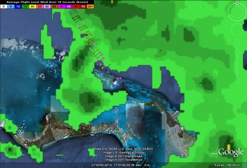
ime: 05:15:00Z
Coordinates: 27.05N 77.85W
Acft. Static Air Press: 849.3 mb (~ 25.08 inHg)
Acft. Geopotential Hgt: 1,486 meters (~ 4,875 feet)
Extrap. Sfc. Press: -
D-value: -
Flt. Lvl. Wind (30s): From 228° at 50 knots (From the SW at ~ 57.5 mph)
Air Temp: 16.6°C* (~ 61.9°F*)
Dew Pt: -*
Peak (10s) Flt. Lvl. Wind: 51 knots (~ 58.6 mph)
SFMR Peak (10s) Sfc. Wind: 49 knots* (~ 56.3 mph*)
SFMR Rain Rate: 12 mm/hr* (~ 0.47 in/hr*)
(*) Denotes suspect data
ATL: BRET - Remnants - Discussion
Moderator: S2k Moderators
-
SouthFloridawx

- S2K Supporter

- Posts: 8346
- Age: 47
- Joined: Tue Jul 26, 2005 1:16 am
- Location: Sarasota, FL
- Contact:


Re: ATL: BRET - Models
ROCK wrote:the 0Z GFS doesnt even acknowledge Bret as a closed low....garbage....I think Jese you were right....so small they cant see it....
Even the almighty NAM doesnt see it.....
so much for help with what it's gonna do!
0 likes
-
SouthFloridawx
- S2K Supporter
- Posts: 8346
- Age: 47
- Joined: Tue Jul 26, 2005 1:16 am
- Location: Sarasota, FL
- Contact:
-
stormhunter7

- Category 2

- Posts: 763
- Joined: Mon May 26, 2008 3:13 pm
- Location: Panama City Beach, Florida
- Contact:
Re: ATL: BRET - Tropical Storm - Discussion
apppears the dwpt sensor on the plane is out? Hopefully a GPSdropsonde will work for a dewpoint measurement!
0 likes
The following post is NOT an official forecast and should not be used as such. It is just the opinion of the poster and may or may not be backed by sound meteorological data. It is NOT endorsed by any professional institution including storm2k.org For Official Information please refer to the NHC and NWS products. http://www.nhc.noaa.gov
Re: ATL: BRET - Tropical Storm - Discussion
SouthFloridawx wrote:Looks like a bunch of 40's.
they keep flagging all the obs yet they are running around what they were when they went in yesterday. I wonder what gives?
0 likes
-
SouthDadeFish

- Professional-Met

- Posts: 2835
- Joined: Thu Sep 23, 2010 2:54 pm
- Location: Miami, FL
- Contact:
-
dwsqos2
Re: ATL: BRET - Recon
000
UZNT13 KNHC 180526
XXAA 68058 99271 70780 08078 99002 27624 22509 00021 27423 22510
92709 22208 23011 85447 20456 27010 88999 77999
31313 09608 80512
61616 AF308 0202A BRET OB 05
62626 EYE SPL 2714N07797W 0514 MBL WND 23510 AEV 20802 DLM WND 23
508 002849 WL150 23010 083 REL 2714N07797W 051229 SPG 2714N07797W
051417 =
XXBB 68058 99271 70780 08078 00002 27624 11927 22207 22904 23447
33850 20456 44849 20256
21212 00002 22509 11917 23511 22885 23504 33862 26004 44849 27011
31313 09608 80512
61616 AF308 0202A BRET OB 05
62626 EYE SPL 2714N07797W 0514 MBL WND 23510 AEV 20802 DLM WND 23
508 002849 WL150 23010 083 REL 2714N07797W 051229 SPG 2714N07797W
051417 =
1002 mb pressure; yeah, it's a bit deeper.
0 likes
-
SouthFloridawx
- S2K Supporter
- Posts: 8346
- Age: 47
- Joined: Tue Jul 26, 2005 1:16 am
- Location: Sarasota, FL
- Contact:
Re: ATL: BRET - Tropical Storm - Discussion
Convection looks to be wrapping around the center. Looks like Bret is getting a bit stronger this evening.

0 likes
-
stormhunter7
- Category 2
- Posts: 763
- Joined: Mon May 26, 2008 3:13 pm
- Location: Panama City Beach, Florida
- Contact:
Re: ATL: BRET - Tropical Storm - Discussion
dropsonde shows 1002mb at Splash Location: 27.14N 77.97W Splash Time: 5:14Z
0 likes
The following post is NOT an official forecast and should not be used as such. It is just the opinion of the poster and may or may not be backed by sound meteorological data. It is NOT endorsed by any professional institution including storm2k.org For Official Information please refer to the NHC and NWS products. http://www.nhc.noaa.gov
-
SouthDadeFish
- Professional-Met
- Posts: 2835
- Joined: Thu Sep 23, 2010 2:54 pm
- Location: Miami, FL
- Contact:
Re: ATL: BRET - Tropical Storm - Discussion
stormhunter7 wrote:dropsonde shows 1002mb at Splash Location: 27.14N 77.97W Splash Time: 5:14Z
Wow, that's a 7mb drop since the last recon flight, if that is correct.
0 likes
-
SouthFloridawx
- S2K Supporter
- Posts: 8346
- Age: 47
- Joined: Tue Jul 26, 2005 1:16 am
- Location: Sarasota, FL
- Contact:
Re: ATL: BRET - Tropical Storm - Discussion
051530 2702N 07750W 8496 01485 //// +170 //// 230050 051 045 000 05
051600 2701N 07748W 8493 01495 //// +170 //// 231051 052 043 000 05
051630 2700N 07747W 8494 01503 //// +164 //// 227051 051 041 001 05
051700 2659N 07746W 8494 01506 //// +157 //// 227049 050 039 000 05
051730 2658N 07745W 8491 01513 //// +155 //// 223047 049 037 002 01
051800 2657N 07743W 8492 01514 //// +160 //// 220045 045 035 001 01
051830 2655N 07742W 8492 01520 //// +167 //// 226044 045 035 000 01
051900 2654N 07741W 8496 01519 //// +168 //// 227042 043 048 003 05
051930 2653N 07740W 8488 01531 //// +169 //// 224041 042 /// /// 05
052000 2652N 07739W 8490 01531 //// +164 //// 221041 042 /// /// 05
052030 2651N 07737W 8490 01534 //// +160 //// 222040 041 036 001 01
0 likes
-
SouthFloridawx
- S2K Supporter
- Posts: 8346
- Age: 47
- Joined: Tue Jul 26, 2005 1:16 am
- Location: Sarasota, FL
- Contact:

-
SouthFloridawx
- S2K Supporter
- Posts: 8346
- Age: 47
- Joined: Tue Jul 26, 2005 1:16 am
- Location: Sarasota, FL
- Contact:
Re:
NDG wrote:I still cannot believe that there were no Tropical storm warnings for the northern Bahamas Islands at the 11 PM advisory.
SUMMARY OF 1100 PM EDT...0300 UTC...INFORMATION
-----------------------------------------------
LOCATION...27.5N 78.0W
ABOUT 95 MI...150 KM NW OF GREAT ABACO ISLAND
MAXIMUM SUSTAINED WINDS...40 MPH...65 KM/H
PRESENT MOVEMENT...SE OR 145 DEGREES AT 2 MPH...4 KM/H
MINIMUM CENTRAL PRESSURE...1009 MB...29.80 INCHES
WATCHES AND WARNINGS
--------------------
CHANGES WITH THIS ADVISORY...
NONE
SUMMARY OF WATCHES AND WARNINGS IN EFFECT...
A TROPICAL STORM WATCH IS IN EFFECT FOR...
* GRAND BAHAMA ISLAND AND THE ABACO ISLANDS IN THE NORTHWEST BAHAMAS
0 likes
-
South Texas Storms

- Professional-Met
- Posts: 4257
- Joined: Thu Jun 24, 2010 12:28 am
- Location: Houston, TX
Re: ATL: BRET - Tropical Storm - Discussion
Any chance this moves into the Gulf and/or becomes a hurricane?
0 likes
Re:
NDG wrote:I still cannot believe that there were no Tropical storm warnings for the northern Bahamas Islands at the 11 PM advisory.
http://forecast.weather.gov/showsigmz.p ... rm+Warning
there was one as of 11:30 see above link
0 likes
-
stormhunter7
- Category 2
- Posts: 763
- Joined: Mon May 26, 2008 3:13 pm
- Location: Panama City Beach, Florida
- Contact:
Re:
NDG wrote:I still cannot believe that there were no Tropical storm warnings for the northern Bahamas Islands at the 11 PM advisory.
base on GEarth measurement for latest recon fix... Center fix is about 27 miles NW of Little Abaco Island at bearing 307. Clearly a TS Warning should of came out for those Islands.. someone dropped the ball i do believe!
0 likes
The following post is NOT an official forecast and should not be used as such. It is just the opinion of the poster and may or may not be backed by sound meteorological data. It is NOT endorsed by any professional institution including storm2k.org For Official Information please refer to the NHC and NWS products. http://www.nhc.noaa.gov
Who is online
Users browsing this forum: No registered users and 13 guests