

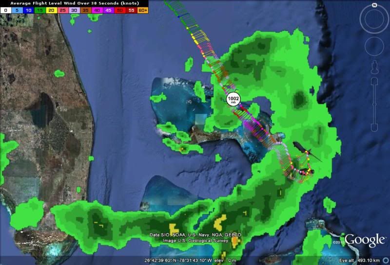
000
URNT12 KNHC 180535
VORTEX DATA MESSAGE AL982011
A. 18/05:12:20Z
B. 27 deg 09 min N
077 deg 59 min W
C. 400 mb 1454 m
D. 49 kt
E. 310 deg 5 nm
F. 048 deg 43 kt
G. 316 deg 8 nm
H. 1002 mb
I. 15 C / 1462 m
J. 21 C / 1473 m
K. NA / NA
L. NA
M. NA
N. 12345 / 4
O. 0.02 / 5 nm
P. AF308 0202A BRET OB 04
MAX FL WIND 43 KT NW QUAD 05:09:40Z
MAX OUTBOUND FL WIND 51 KT SE QUAD 05:16:40Z
Banding North and East on radar
;
ATL: BRET - Remnants - Discussion
Moderator: S2k Moderators
Re: Re:
stormhunter7 wrote:NDG wrote:I still cannot believe that there were no Tropical storm warnings for the northern Bahamas Islands at the 11 PM advisory.
base on GEarth measurement for latest recon fix... Center fix is about 27 miles NW of Little Abaco Island at bearing 307. Clearly a TS Warning should of came out for those Islands.. someone dropped the ball i do believe!
as of 11:30 there was one-
Tropical Storm Warning
AMZ080-180930-
SW N ATLANTIC S OF 31N W OF 65W INCLUDING BAHAMAS
1130 PM EDT SUN JUL 17 2011
...TROPICAL STORM WARNING N OF 26N BETWEEN 74W AND 78W...
.TONIGHT AND MON...TROPICAL STORM FORCE WINDS WITHIN 30 NM OF
CENTER EXCEPT 0 NM SW QUADRANT...INCREASING TO 40 NM OF CENTER
EXCEPT 20 NM SW QUADRANT ON MON. HIGHEST WINDS 35 KT GUST TO 45
KT INCREASING TO 40 KT GUSTS TO 50 KT MON. SEAS 7 TO 10 FT...
BUILDING TO 9 TO 15 FT MON WITH SEAS 12 FT OR GREATER WITHIN
AREA OF TROPICAL STORM FORCE WINDS LATE TONIGHT AND MON.
ELSEWHERE WITHIN 60 NM OF BRET WINDS 20 TO 33 KT EXPANDING TO
WITHIN 120 NM OF BRET MON. SEAS 5 TO 8 FT BUILDING TO 8 TO 12 FT
N OF BAHAMAS MON. ELSEWHERE N OF 26N W OF 77W N TO NE WINDS 15
TO 20 KT. SEAS 4 TO 7 FT. N OF 26N E OF 77W SE TO S WINDS 10 TO
15 KT. SEAS 5 TO 7 FT. S OF 26N W OF 76W SE WINDS 5 TO 10 KT.
SEAS 1 TO 2 FT. S OF 26N E OF 76W E TO SE WINDS 10 TO 15 KT
EXCEPT 15 TO 20 KT S OF 22N E OF 74W. SEAS 4 TO 7 FT EXCEPT 3 TO
5 FT W OF BAHAMAS.
.MON NIGHT THROUGH WED...TROPICAL STORM FORCE WINDS WITHIN 50 NM
OF CENTER...EXCEPT 30 NM SW QUADRANT...INCREASING TO 60 NM OF
CENTER...EXCEPT 50 NM SW QUADRANT TUE MORNING...AND TO 75 NM
OF CENTER...EXCEPT 60 NM SW QUADRANT TUE NIGHT. HIGHEST WINDS 50
KT GUSTS 60 KT...DIMINISHING TO 45 KT GUSTS TO 55 KT TUE NIGHT.
SEAS 12 FT OR GREATER IN AREA OF TROPICAL STORM FORCE WINDS.
HIGHEST SEAS BUILDING TO 18 FT. ELSEWHERE WITHIN 150 NM OF BRET
WINDS 20 TO 33 KT. SEAS 8 TO 12 FT. ELSEWHERE N OF 27N W OF 77W
NW TO N WINDS 10 TO 15 KT. SEAS 4 TO 7 FT. ELSEWHERE N OF 27N E
OF 77W S TO SW WINDS 15 TO 20 KT. SEAS 5 TO 8 FT. S OF 22N E OF
74W E TO SE WINDS 15 TO 20 KT. SEAS 4 TO 7 FT. REMAINDER AREA SE
WINDS 10 KT. SEAS 4 TO 6 FT EXCEPT 1 TO 3 FT W OF BAHAMAS.
.THU AND FRI...N OF 27N SW WINDS 10 TO 15 KT...EXCEPT 5 TO 10 KT
E OF 60W. SEAS 2 TO 4 FT. FROM 25N TO 27N SE TO S WINDS 5 TO 10
KT. SEAS 3 TO 4 FT...EXCEPT 1 TO 2 FT W OF BAHAMAS. FROM 23N TO
25N SE TO E WINDS 10 TO 15 KT. SEAS 4 TO 5 FT...EXCEPT 2 TO 3 FT
W OF BAHAMAS. S OF 23N E TO SE WINDS 10 TO 15 KT INCREASING TO
15 TO 20 KT FRI. SEAS 4 TO 6 FT INCREASING TO 5 TO 8 FT...EXCEPT
3 TO 5 FT W OF BAHAMAS.
$$
FORECASTER SCHAUER
0 likes

Re: Re:
artist wrote:NDG wrote:I still cannot believe that there were no Tropical storm warnings for the northern Bahamas Islands at the 11 PM advisory.
http://forecast.weather.gov/showsigmz.p ... rm+Warning
there was one as of 11:30 see above link
Again, there were no Tropical Storm Warnings put out by the Bahamian Gov't tonight for the northern Bahamian Islands.
BULLETIN
TROPICAL STORM BRET ADVISORY NUMBER 2
NWS NATIONAL HURRICANE CENTER MIAMI FL AL022011
1100 PM EDT SUN JUL 17 2011
...BRET DRIFTING SOUTHEASTWARD...EXPECTED TO BEGIN MOVING
NORTH-NORTHEASTWARD ON MONDAY...
SUMMARY OF 1100 PM EDT...0300 UTC...INFORMATION
-----------------------------------------------
LOCATION...27.5N 78.0W
ABOUT 95 MI...150 KM NW OF GREAT ABACO ISLAND
MAXIMUM SUSTAINED WINDS...40 MPH...65 KM/H
PRESENT MOVEMENT...SE OR 145 DEGREES AT 2 MPH...4 KM/H
MINIMUM CENTRAL PRESSURE...1009 MB...29.80 INCHES
WATCHES AND WARNINGS
--------------------
CHANGES WITH THIS ADVISORY...
NONE
SUMMARY OF WATCHES AND WARNINGS IN EFFECT...
A TROPICAL STORM WATCH IS IN EFFECT FOR...
* GRAND BAHAMA ISLAND AND THE ABACO ISLANDS IN THE NORTHWEST BAHAMASA TROPICAL STORM WATCH MEANS THAT TROPICAL STORM CONDITIONS ARE
POSSIBLE WITHIN THE WATCH AREA...IN THIS CASE WITHIN THE NEXT 24
HOURS.
Last edited by NDG on Mon Jul 18, 2011 12:46 am, edited 1 time in total.
0 likes
000
URNT15 KNHC 180535
AF308 0202A BRET HDOB 19 20110718
052530 2640N 07725W 8486 01553 //// +161 //// 230037 038 046 004 05
052600 2638N 07724W 8480 01555 //// +160 //// 234036 036 034 001 01
052630 2637N 07723W 8500 01537 //// +160 //// 231036 037 038 001 05
052700 2636N 07722W 8491 01552 //// +160 //// 229036 036 /// /// 05
052730 2635N 07720W 8498 01545 //// +159 //// 224032 033 051 005 05
052800 2635N 07718W 8494 01548 //// +154 //// 225033 034 /// /// 05
052830 2635N 07716W 8492 01551 //// +157 //// 227033 035 /// /// 05
052900 2634N 07714W 8500 01545 //// +159 //// 224031 032 /// /// 05
052930 2633N 07713W 8489 01555 //// +160 //// 225031 032 /// /// 05
053000 2632N 07712W 8500 01545 //// +158 //// 225031 032 /// /// 05
053030 2630N 07712W 8490 01557 //// +156 //// 228032 032 /// /// 05
053100 2629N 07711W 8491 01555 //// +157 //// 230031 032 052 005 05
053130 2627N 07711W 8499 01547 //// +155 //// 231031 032 /// /// 05
053200 2626N 07710W 8488 01559 //// +158 //// 233030 030 /// /// 05
053230 2625N 07709W 8494 01555 //// +160 //// 233029 029 /// /// 05
053300 2623N 07709W 8494 01557 //// +160 //// 234029 029 /// /// 05
053330 2622N 07708W 8493 01557 //// +163 //// 235027 028 /// /// 05
053400 2620N 07708W 8494 01557 //// +163 //// 228026 028 /// /// 05
053430 2619N 07707W 8492 01559 //// +160 //// 220022 023 /// /// 05
053500 2617N 07707W 8493 01560 //// +159 //// 220026 028 /// /// 05
flagged that both are suspect
0 likes
-
stormhunter7

- Category 2

- Posts: 763
- Joined: Mon May 26, 2008 3:13 pm
- Location: Panama City Beach, Florida
- Contact:
Re: ATL: BRET - Tropical Storm - Discussion
thats appears thats for the Atlantic Waters... not for the Islands? Theres a watch for the islands per this map... http://www.nhc.noaa.gov/storm_graphics/ ... _NL_sm.gif
but now WARNING, except for AMZ080 in the Atlantic
but now WARNING, except for AMZ080 in the Atlantic
0 likes
The following post is NOT an official forecast and should not be used as such. It is just the opinion of the poster and may or may not be backed by sound meteorological data. It is NOT endorsed by any professional institution including storm2k.org For Official Information please refer to the NHC and NWS products. http://www.nhc.noaa.gov
-
SouthDadeFish

- Professional-Met

- Posts: 2835
- Joined: Thu Sep 23, 2010 2:54 pm
- Location: Miami, FL
- Contact:
-
lester

- S2K Supporter

- Posts: 1305
- Age: 37
- Joined: Sat Aug 27, 2005 5:21 pm
- Location: Washington, DC
- Contact:
Re: ATL: BRET - Tropical Storm - Discussion
They prolly didn't anticipate the system going that far south
0 likes
-
HurricaneBrain

- S2K Supporter
- Posts: 520
- Joined: Thu Jun 30, 2011 2:07 pm
Re: ATL: BRET - Tropical Storm - Discussion
South Texas Storms wrote:Any chance this moves into the Gulf and/or becomes a hurricane?
Certainly a chance but it's too far out to tell. I am hoping the Euro verifies. We may see a significant shift west of the models tomorrow.
0 likes
-
bamajammer4eva
- Category 4

- Posts: 907
- Joined: Sun Apr 18, 2010 3:21 am
- Location: Ozark, AL
Re: ATL: BRET - Tropical Storm - Discussion
Bahama Bret Advisory
http://www.bahamasweather.org.bs/index.php?mact=News,cntnt01,detail,0&cntnt01articleid=11&cntnt01returnid=88
NW Bahamas/ Aboco forecast
http://www.bahamasweather.org.bs/index.php?page=publicforecastnorthwest
http://www.bahamasweather.org.bs/index.php?mact=News,cntnt01,detail,0&cntnt01articleid=11&cntnt01returnid=88
NW Bahamas/ Aboco forecast
http://www.bahamasweather.org.bs/index.php?page=publicforecastnorthwest
Last edited by bamajammer4eva on Mon Jul 18, 2011 12:51 am, edited 2 times in total.
0 likes
-
South Texas Storms

- Professional-Met
- Posts: 4257
- Joined: Thu Jun 24, 2010 12:28 am
- Location: Houston, TX
Re: ATL: BRET - Tropical Storm - Discussion
HurricaneBrain wrote:South Texas Storms wrote:Any chance this moves into the Gulf and/or becomes a hurricane?
Certainly a chance but it's too far out to tell. I am hoping the Euro verifies. We may see a significant shift west of the models tomorrow.
What does the Euro show?
0 likes
Re: Re:
NDG wrote:artist wrote:NDG wrote:I still cannot believe that there were no Tropical storm warnings for the northern Bahamas Islands at the 11 PM advisory.
http://forecast.weather.gov/showsigmz.p ... rm+Warning
there was one as of 11:30 see above link
Again, there were no Tropical Storm Warnings put out by the Bahamian Gov't tonight for the northern Bahamian Islands.
Sorry, I misunderstood. Since you mentioned the 11 time I was thinking you meant by NOAA for the Bahamas. Seems they may be worse than Jamaica.
0 likes
000
URNT15 KNHC 180545
AF308 0202A BRET HDOB 20 20110718
053530 2616N 07706W 8490 01560 //// +152 //// 219029 030 033 003 05
053600 2615N 07706W 8492 01558 //// +134 //// 216028 029 032 010 05
053630 2614N 07704W 8492 01559 //// +149 //// 210031 032 028 007 05
053700 2613N 07702W 8493 01558 //// +156 //// 210029 030 030 009 01
053730 2613N 07701W 8492 01562 //// +147 //// 202031 032 032 011 05
053800 2612N 07659W 8493 01566 //// +156 //// 196031 035 027 009 01
053830 2612N 07657W 8487 01570 //// +155 //// 186027 029 024 006 01
053900 2611N 07656W 8494 01558 //// +155 //// 203025 027 022 002 05
053930 2610N 07654W 8495 01558 //// +156 //// 207025 026 021 001 05
054000 2611N 07653W 8492 01562 //// +156 //// 202024 024 018 002 05
054030 2613N 07652W 8490 01564 //// +155 //// 193024 025 021 001 01
054100 2614N 07651W 8494 01557 //// +153 //// 186024 024 019 002 05
054130 2616N 07651W 8481 01566 //// +155 //// 163029 031 024 003 01
054200 2618N 07652W 8500 01546 //// +153 //// 166025 032 024 004 01
054230 2620N 07652W 8490 01557 //// +145 //// 190016 020 029 009 01
054300 2622N 07652W 8498 01549 //// +142 //// 215022 025 044 018 05
054330 2623N 07653W 8491 01554 //// +135 //// 217029 031 051 018 01
054400 2625N 07653W 8498 01548 //// +124 //// 237030 031 043 022 05
054430 2627N 07653W 8480 01571 //// +145 //// 238026 027 034 014 01
054500 2628N 07654W 8495 01557 //// +161 //// 238023 025 035 007 01
$$
;
0 likes
-
SouthFloridawx

- S2K Supporter
- Posts: 8346
- Age: 47
- Joined: Tue Jul 26, 2005 1:16 am
- Location: Sarasota, FL
- Contact:
-
SouthDadeFish
- Professional-Met
- Posts: 2835
- Joined: Thu Sep 23, 2010 2:54 pm
- Location: Miami, FL
- Contact:
-
HurricaneBrain
- S2K Supporter
- Posts: 520
- Joined: Thu Jun 30, 2011 2:07 pm
Re: ATL: BRET - Tropical Storm - Discussion
South Texas Storms wrote:HurricaneBrain wrote:South Texas Storms wrote:Any chance this moves into the Gulf and/or becomes a hurricane?
Certainly a chance but it's too far out to tell. I am hoping the Euro verifies. We may see a significant shift west of the models tomorrow.
What does the Euro show?
It shows Bret moving south of Florida into the Gulf. We'll have to wait and see. If Bret is still moving south in 12 hours the gulf coast may catch a surprise.
0 likes
000
URNT15 KNHC 180555
AF308 0202A BRET HDOB 21 20110718
054530 2630N 07654W 8499 01555 //// +153 //// 232023 024 033 005 05
054600 2632N 07654W 8486 01565 //// +141 //// 213020 023 033 010 01
054630 2633N 07654W 8498 01553 //// +137 //// 187021 023 038 010 05
054700 2635N 07654W 8495 01552 //// +151 //// 189025 027 038 006 01
054730 2637N 07654W 8491 01554 //// +150 //// 179030 033 030 008 01
054800 2639N 07654W 8498 01548 //// +150 //// 177030 032 033 009 01
054830 2641N 07654W 8492 01552 //// +157 //// 181029 030 031 010 01
054900 2643N 07654W 8495 01547 //// +152 //// 178034 036 032 010 01
054930 2645N 07654W 8495 01547 //// +152 //// 177034 036 028 006 05
055000 2646N 07654W 8493 01548 //// +155 //// 179035 037 025 006 01
055030 2648N 07654W 8492 01549 //// +157 //// 183036 037 027 004 05
055100 2650N 07654W 8492 01549 //// +156 //// 182036 037 029 004 01
055130 2652N 07654W 8495 01545 //// +156 //// 180037 038 028 005 01
055200 2654N 07654W 8494 01546 //// +158 //// 178037 037 027 003 05
055230 2656N 07654W 8494 01545 //// +163 //// 179039 039 026 001 01
055300 2658N 07654W 8491 01549 //// +161 //// 183039 040 026 000 01
055330 2700N 07654W 8496 01542 //// +165 //// 190037 038 026 001 05
055400 2702N 07654W 8491 01547 //// +165 //// 194039 040 025 000 01
055430 2704N 07654W 8494 01545 //// +165 //// 191040 041 025 000 01
055500 2706N 07654W 8493 01546 //// +165 //// 188041 042 028 001 05
$$
0 likes
Re: ATL: BRET - Tropical Storm - Discussion
HurricaneBrain wrote:South Texas Storms wrote:HurricaneBrain wrote:Certainly a chance but it's too far out to tell. I am hoping the Euro verifies. We may see a significant shift west of the models tomorrow.
What does the Euro show?
It shows Bret moving south of Florida into the Gulf. We'll have to wait and see. If Bret is still moving south in 12 hours the gulf coast may catch a surprise.
The system that the euro shows at hour 216 & 240 is not Bret, it shows Bret moving eventually NE in a couple of days.
The system that it shows in its long range is from the strong tropical wave that is in the far eastern Atlantic.
0 likes
Who is online
Users browsing this forum: No registered users and 18 guests