
Anther good analog for 4-E/Dora is Fausto 08 track wise. Intensity wise, a good anolog is Bud 06.

Moderator: S2k Moderators


plasticup wrote:CrazyC83 wrote:How strong will this get I wonder? Could this go all the way to Category 5?
NHC says 2%, which is about as bullish as they ever are this far out. It's going to be an impressive one!


The posts in this forum are NOT official forecast and should not be used as such. They are just the opinion of the poster and may or may not be backed by sound meteorological data. They are NOT endorsed by any professional institution or storm2k.org. For official information, please refer to the NHC and NWS products.
 Howard 04 except a little more southwesterly.

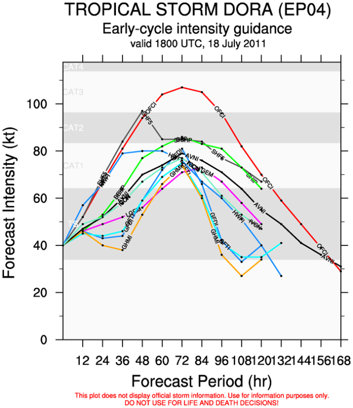
Code: Select all
WHXX01 KMIA 181904
CHGE77
TROPICAL CYCLONE GUIDANCE MESSAGE
NWS NATIONAL HURRICANE CENTER MIAMI FL
1904 UTC MON JUL 18 2011

DISCLAIMER...NUMERICAL MODELS ARE SUBJECT TO LARGE ERRORS.
PLEASE REFER TO NHC OFFICIAL FORECASTS FOR TROPICAL CYCLONE
AND SUBTROPICAL CYCLONE INFORMATION.

EAST PACIFIC OBJECTIVE AIDS FOR

TROPICAL CYCLONE DORA (EP042011) 20110718 1800 UTC

        ...00 HRS...   ...12 HRS...   ...24 HRS. ..   ...36 HRS...
        110718  1800   110719  0600   110719  1800   110720  0600

         LAT    LON     LAT    LON     LAT    LON     LAT    LON
BAMS    10.6N  92.3W   11.0N  94.9W   11.6N  97.6W   12.6N  99.8W
BAMD    10.6N  92.3W   11.0N  94.4W   11.9N  96.5W   13.1N  98.6W
BAMM    10.6N  92.3W   11.3N  95.0W   12.2N  97.8W   13.5N 100.4W
LBAR    10.6N  92.3W   11.3N  94.7W   12.3N  97.6W   13.8N 100.5W
SHIP        40KTS          46KTS          53KTS          64KTS
DSHP        40KTS          46KTS          53KTS          64KTS

        ...48 HRS...   ...72 HRS...   ...96 HRS. ..   ..120 HRS...
        110720  1800   110721  1800   110722  1800   110723  1800

         LAT    LON     LAT    LON     LAT    LON     LAT    LON
BAMS    14.0N 102.0W   17.3N 106.3W   20.4N 110.3W   22.3N 114.9W
BAMD    14.5N 100.8W   17.5N 104.4W   20.1N 107.1W   22.3N 110.6W
BAMM    14.9N 103.0W   17.7N 107.5W   19.8N 111.0W   21.0N 114.9W
LBAR    15.1N 103.3W   17.7N 107.8W   19.3N 111.0W   19.9N 114.3W
SHIP        77KTS          86KTS          81KTS          64KTS
DSHP        77KTS          86KTS          81KTS          64KTS

         ...INITIAL CONDITIONS...
LATCUR =  10.6N LONCUR =  92.3W DIRCUR = 280DEG SPDCUR =  11KT
LATM12 =  10.3N LONM12 =  90.0W DIRM12 = 281DEG SPDM12 =  11KT
LATM24 =  10.0N LONM24 =  88.0W
WNDCUR =   40KT RMAXWD =   30NM WNDM12 =   30KT
CENPRS = 1004MB OUTPRS = 1010MB OUTRAD =  180NM SDEPTH =   D
RD34NE =   50NM RD34SE =   60NM RD34SW =    0NM RD34NW =   0NM

Kingarabian wrote:Unless.... It goes annular. I remember Daniel of 06/Flossie of 07/Felicia of 09 lasted longer and got stronger than farcasted because of their annular characteristics. But they were far off in the epac...
Macrocane wrote:Just like Bret, Dora is not wasting any time and it has been organizing fairly quick, and by the way it has been raining in San Salvador this afternoon, Dora may not be directly responsible for this rains but it has enhanced the moisture flow from the Pacific ocean into the country.

cycloneye wrote:Macrocane wrote:Just like Bret, Dora is not wasting any time and it has been organizing fairly quick, and by the way it has been raining in San Salvador this afternoon, Dora may not be directly responsible for this rains but it has enhanced the moisture flow from the Pacific ocean into the country.
I am ahead of myself,but all looks like Dora will reach hurricane status and that event for the EPAC will be very interesting as the first 4 cyclones are hurricanes.


Users browsing this forum: No registered users and 26 guests


