Pouch 07L approaching Lesser Antilles - (Is invest 90L)

This is the general tropical discussion area. Anyone can take their shot at predicting a storms path.

Moderator: S2k Moderators

Forum rules

The posts in this forum are NOT official forecasts and should not be used as such. They are just the opinion of the poster and may or may not be backed by sound meteorological data. They are NOT endorsed by any professional institution or STORM2K. For official information, please refer to products from the National Hurricane Center and National Weather Service.

Help Support Storm2K
Message
Author
User avatar
cycloneye
Admin
Admin
Posts: 145455
Age: 68
Joined: Thu Oct 10, 2002 10:54 am
Location: San Juan, Puerto Rico

Re: Early start to CV season? Wave in E Atlantic a candidate?

#41 Postby cycloneye » Tue Jul 19, 2011 1:18 pm

Ellsey wrote:Sorry if this is a noob question, but is CV season talking about when Cape Verde? When you start watching the waves coming off Africa? That's always my husband's favorite time of year. He used to live in Praia, Cape Verde. He said it was almost constantly cloudy around this time of year.


Yes,Cape Verde islands are the ones that are always referred as the area where the tropical waves move off Africa and later if conditions are favorable,start to organize and develop.
0 likes   
Visit the Caribbean-Central America Weather Thread where you can find at first post web cams,radars
and observations from Caribbean basin members Click Here

User avatar
Ivanhater
Storm2k Moderator
Storm2k Moderator
Posts: 11162
Age: 38
Joined: Fri Jul 01, 2005 8:25 am
Location: Pensacola

Re: Early start to CV season? Wave in E Atlantic a candidate?

#42 Postby Ivanhater » Tue Jul 19, 2011 1:37 pm

12z Euro jumps back on board..out to 144 hours so far

Could develop before hitting the NE Islands

[img]Image

Uploaded with ImageShack.us[/img]

[img]Image

Uploaded with ImageShack.us[/img]
0 likes   
Michael

User avatar
Ivanhater
Storm2k Moderator
Storm2k Moderator
Posts: 11162
Age: 38
Joined: Fri Jul 01, 2005 8:25 am
Location: Pensacola

Re: Early start to CV season? Wave in E Atlantic a candidate?

#43 Postby Ivanhater » Tue Jul 19, 2011 1:48 pm

72 hours

Image
0 likes   
Michael

User avatar
Ivanhater
Storm2k Moderator
Storm2k Moderator
Posts: 11162
Age: 38
Joined: Fri Jul 01, 2005 8:25 am
Location: Pensacola

Re: Early start to CV season? Wave in E Atlantic a candidate?

#44 Postby Ivanhater » Tue Jul 19, 2011 2:44 pm

Ukie is sniffing it out as well

[img]Image

Uploaded with ImageShack.us[/img]
0 likes   
Michael

User avatar
ronjon
Category 5
Category 5
Posts: 4822
Joined: Fri Aug 19, 2005 5:17 pm
Location: Hernando Beach, FL

Re: Early start to CV season? Wave in E Atlantic a candidate?

#45 Postby ronjon » Tue Jul 19, 2011 2:58 pm

Michael, 12Z Euro brings low pressure into S FL in 10 days. Too far out for track, but Euro and CMC on the same page with potential development of the 35W wave.

http://raleighwx.americanwx.com/models/euro/12zeurotropical850mbVortSLP_loop.html
0 likes   

User avatar
Ivanhater
Storm2k Moderator
Storm2k Moderator
Posts: 11162
Age: 38
Joined: Fri Jul 01, 2005 8:25 am
Location: Pensacola

Re: Early start to CV season? Wave in E Atlantic a candidate?

#46 Postby Ivanhater » Tue Jul 19, 2011 3:03 pm

ronjon wrote:Michael, 12Z Euro brings low pressure into S FL in 10 days. Too far out for track, but Euro and CMC on the same page with potential development of the 35W wave.

http://raleighwx.americanwx.com/models/euro/12zeurotropical850mbVortSLP_loop.html


Yep Ron...take a look at the long range 12z Canadian.

Develops it into a pretty strong system but curves it out to sea. Not interested in track that far out but it is interesting.

Image
0 likes   
Michael

User avatar
ronjon
Category 5
Category 5
Posts: 4822
Joined: Fri Aug 19, 2005 5:17 pm
Location: Hernando Beach, FL

Re: Early start to CV season? Wave in E Atlantic a candidate?

#47 Postby ronjon » Tue Jul 19, 2011 3:09 pm

It's way out there, but 12Z euro builds massive ridging over the Atlantic in the 7-10 day time frame. Have to watch the model trends over the next few days to see if that's confirmed. Any support from the ensembles?
0 likes   

User avatar
wxman57
Moderator-Pro Met
Moderator-Pro Met
Posts: 22980
Age: 67
Joined: Sat Jun 21, 2003 8:06 pm
Location: Houston, TX (southwest)

Re: Early start to CV season? Wave in E Atlantic a candidate?

#48 Postby wxman57 » Tue Jul 19, 2011 3:39 pm

It definitely has a classic pre-TC development look on the MIMIC-TPW loop:
http://cimss.ssec.wisc.edu/tropic/real- ... /main.html

Good rotation and copious moisture. SSTs warm as it moves west. Could be a development threat in 2-3 days. Possibly a threat to the southeast U.S. next week.
0 likes   

User avatar
SFLcane
S2K Supporter
S2K Supporter
Posts: 10163
Age: 47
Joined: Sat Jun 05, 2010 1:44 pm
Location: Lake Worth Florida

Re: Early start to CV season? Wave in E Atlantic a candidate?

#49 Postby SFLcane » Tue Jul 19, 2011 4:01 pm

With plenty of trofiness over the southern u.s. i'd think any cv storm trying to make the long trek will probably recurve.
0 likes   

User avatar
PTrackerLA
Category 5
Category 5
Posts: 5277
Age: 41
Joined: Thu Oct 10, 2002 8:40 pm
Location: Lafayette, LA

Re: Early start to CV season? Wave in E Atlantic a candidate?

#50 Postby PTrackerLA » Tue Jul 19, 2011 4:45 pm

Like wxman said definitely has the "look" on the CIMSS. I'll be watching this one closely!
0 likes   

User avatar
HURAKAN
Professional-Met
Professional-Met
Posts: 46086
Age: 38
Joined: Thu May 20, 2004 4:34 pm
Location: Key West, FL
Contact:

#51 Postby HURAKAN » Tue Jul 19, 2011 4:49 pm

Image

HPC in 7 days ... needs to be taken with a grain of salt!
0 likes   

User avatar
KWT
Category 5
Category 5
Posts: 31415
Joined: Tue Aug 17, 2004 11:02 am
Location: UK!!!

#52 Postby KWT » Tue Jul 19, 2011 4:57 pm

Interesting, it reminds me somewhat of Dolly from 2008...I think this is our first real candidate from Africa...

Then again could easily just turn into another Bonnie 2010...
0 likes   
Personal Forecast Disclaimer:
The posts in this forum are NOT official forecast and should not be used as such. They are just the opinion of the poster and may or may not be backed by sound meteorological data. They are NOT endorsed by any professional institution or storm2k.org. For official information, please refer to the NHC and NWS products

User avatar
NDG
S2K Supporter
S2K Supporter
Posts: 15446
Joined: Sun Jul 09, 2006 10:14 pm
Location: Orlando, FL

#53 Postby NDG » Tue Jul 19, 2011 5:19 pm

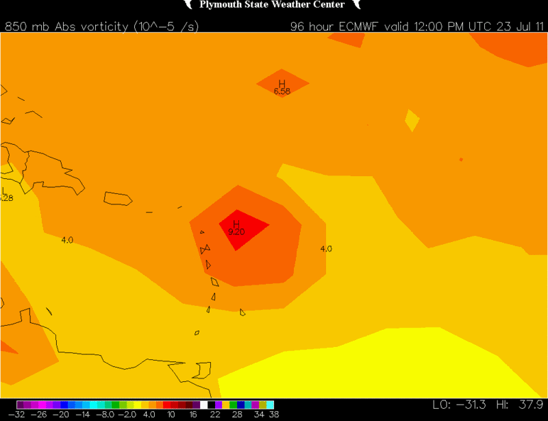
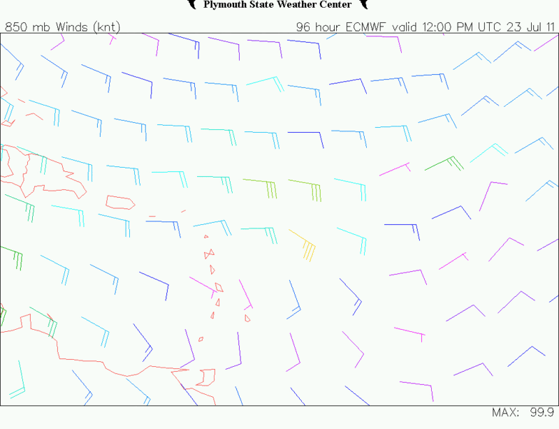
12z ECMWF shows almost perfect upper level conditions for this tropical wave as it nears the northern Windward and or Leeward Islands Saturday morning.
With strong H85 vorticity and a sharp trough.

Image
Image
Image
Image
0 likes   

User avatar
gatorcane
S2K Supporter
S2K Supporter
Posts: 23691
Age: 47
Joined: Sun Mar 13, 2005 3:54 pm
Location: Boca Raton, FL

Re: Early start to CV season? Wave in E Atlantic a candidate?

#54 Postby gatorcane » Tue Jul 19, 2011 5:40 pm

wxman57 wrote:It definitely has a classic pre-TC development look on the MIMIC-TPW loop:
http://cimss.ssec.wisc.edu/tropic/real- ... /main.html

Good rotation and copious moisture. SSTs warm as it moves west. Could be a development threat in 2-3 days. Possibly a threat to the southeast U.S. next week.


Will be watching this for sure. Haven't had a lot of time to scope out the steering currents and models on this but will start doing so.

What I can see from the models so far is that CMC/Euro are trying to recurve in the long-range already...with the Euro clipping South Florida but as a weaker system. CMC has a deeper system and recurves it.

Of course this is so far out and we don't even have a system yet. So mere speculation at this point.
0 likes   

User avatar
BigA
Professional-Met
Professional-Met
Posts: 1317
Joined: Sun Jul 24, 2005 10:56 pm

Re: Early start to CV season? Wave in E Atlantic a candidate?

#55 Postby BigA » Tue Jul 19, 2011 6:13 pm

18Z NOGAPS, quite fallible of course, is also a-go.

Image

Uploaded with ImageShack.us
0 likes   

User avatar
Blown Away
S2K Supporter
S2K Supporter
Posts: 10147
Joined: Wed May 26, 2004 6:17 am

Re:

#56 Postby Blown Away » Tue Jul 19, 2011 6:48 pm

NDG wrote:12z ECMWF shows almost perfect upper level conditions for this tropical wave as it nears the northern Windward and or Leeward Islands Saturday morning.
With strong H85 vorticity and a sharp trough.


How do you read "sharp trough?"
0 likes   
Hurricane Eye Experience: David 79, Irene 99, Frances 04, Jeanne 04, Wilma 05... EYE COMING MY WAY IN 2024…
Hurricane Brush Experience: Andrew 92, Erin 95, Floyd 99, Matthew 16, Irma 17, Ian 22, Nicole 22…

User avatar
cycloneye
Admin
Admin
Posts: 145455
Age: 68
Joined: Thu Oct 10, 2002 10:54 am
Location: San Juan, Puerto Rico

Re: Early start to CV season? Wave in E Atlantic a candidate?

#57 Postby cycloneye » Tue Jul 19, 2011 7:01 pm

The pouches are back!. This wave is PO7L. This study group of the waves have been doing good research on the waves for the past few years.

http://met.nps.edu/~mtmontgo/P07L.html


P07L
13N, 34W
700hPa


ECMWF: It takes 24 hours to get a pouch, but then P07L maintains itself until at least 120 hours, but it does not intensify like UKMET.

GFS: A distinct, large pouch at analysis. As other models have been suggesting, a secondary OW max develops on the eastern side of the pouch at 24 hours. While other models intensify that as the main pouch center, it is only temporary for GFS. GFS continues to hold to its story of the initial western pouch maintaining itself, although as a weakening pouch that moves southwest and then northwest into the Caribbean.

UKMET: The secondary OW max development now occurs quickly at 12 hours. P07L then intensifies into, most likely, a tropical storm.

NOGAPS: The secondary eastern development occurs at 24 hours. Unlike UKMET, NOGAPS then dissipates P07L.

0 likes   
Visit the Caribbean-Central America Weather Thread where you can find at first post web cams,radars
and observations from Caribbean basin members Click Here

User avatar
ronjon
Category 5
Category 5
Posts: 4822
Joined: Fri Aug 19, 2005 5:17 pm
Location: Hernando Beach, FL

Re: Early start to CV season? Wave in E Atlantic a candidate?

#58 Postby ronjon » Tue Jul 19, 2011 7:06 pm

12z Euro ensemble model shows extensive ridging building in the western Atlantic in the 8-10 day time frame. If this happens, (a big if this far out), recurve in the open atlantic looks less likely with the wave near 35W.

http://raleighwx.americanwx.com/models/ecmwfens/12zecmwfenstropical500mbSLP216.gif
0 likes   

User avatar
Ivanhater
Storm2k Moderator
Storm2k Moderator
Posts: 11162
Age: 38
Joined: Fri Jul 01, 2005 8:25 am
Location: Pensacola

Re: Early start to CV season? Wave in E Atlantic a candidate?

#59 Postby Ivanhater » Tue Jul 19, 2011 7:21 pm

I see that Ron, but ridging is much weaker on the ensemble and operational prior to 216 hours. If this develops earlier on it could find the weakness. Canadian ensembles have a weakness prior to 200 hours but quickly build the ridge back in similar to the Euro. The UKMET which develops this into a TS has a stronger ridge through 120 hours. As, always, this will depend on timing and when it develops. All just speculation this far out :D
0 likes   
Michael

User avatar
Vortex
S2K Supporter
S2K Supporter
Posts: 4644
Age: 53
Joined: Fri Aug 01, 2003 9:34 pm
Location: Hilton Head, SC

#60 Postby Vortex » Tue Jul 19, 2011 8:19 pm

Got my eye on it.....Bring on the 00z models...
0 likes   


Return to “Talkin' Tropics”

Who is online

Users browsing this forum: cycloneye, Google Adsense [Bot] and 69 guests