WPAC: NOCK-TEN (Juaning) - Tropical Depression
Moderator: S2k Moderators
-
StormingB81

- S2K Supporter

- Posts: 5676
- Age: 44
- Joined: Thu Aug 27, 2009 1:45 am
- Location: Rockledge, Florida
WPAC: NOCK-TEN (Juaning) - Tropical Depression
New one just popped up located at 8N 139E Southwest of guam..
Last edited by StormingB81 on Tue Jul 26, 2011 8:53 pm, edited 3 times in total.
0 likes
-
somethingfunny

- ChatStaff

- Posts: 3926
- Age: 37
- Joined: Thu May 31, 2007 10:30 pm
- Location: McKinney, Texas
-
StormingB81
- S2K Supporter
- Posts: 5676
- Age: 44
- Joined: Thu Aug 27, 2009 1:45 am
- Location: Rockledge, Florida
-
climateconcern23
- Tropical Low

- Posts: 35
- Age: 35
- Joined: Sat Mar 05, 2011 4:38 am
- Location: Philippines
- Contact:


Re:
somethingfunny wrote:Is this the one that's gotten a fair bit of model support?
I believe that is the case. I'm not sure whether its this area the 00z ECM weakly develops on its 00z run or something else.
0 likes
Personal Forecast Disclaimer:
The posts in this forum are NOT official forecast and should not be used as such. They are just the opinion of the poster and may or may not be backed by sound meteorological data. They are NOT endorsed by any professional institution or storm2k.org. For official information, please refer to the NHC and NWS products
The posts in this forum are NOT official forecast and should not be used as such. They are just the opinion of the poster and may or may not be backed by sound meteorological data. They are NOT endorsed by any professional institution or storm2k.org. For official information, please refer to the NHC and NWS products
-
StormingB81
- S2K Supporter
- Posts: 5676
- Age: 44
- Joined: Thu Aug 27, 2009 1:45 am
- Location: Rockledge, Florida
ECMWF really shows it developing on the 12z model but while still early shows it going ot the right of Okinawa looks like may be headed the same direction (after the turn) that Ma-on just did...that would be bad for all those who just got all that ain from ma-on to get another tropical system and get soaked again!
0 likes
-
ManilaTC

- WesternPacificWeather.com

- Posts: 593
- Age: 47
- Joined: Mon Oct 26, 2009 5:13 am
- Location: Mandaluyong City, Philippines
- Contact:
Re: WPAC: INVEST 93W
CMC and GFS runs take it to Luzon or Taiwan though.
0 likes
The above post is NOT official and should not be used as such. It is my opinion and may or may not be backed by sound meteorological data. It is not endorsed by any professional institution or storm2k.org. Please refer to your official national weather agency.
WEB http://goo.gl/JDiKXB | FB https://goo.gl/N5sIle | @ManilaTC
WEB http://goo.gl/JDiKXB | FB https://goo.gl/N5sIle | @ManilaTC
-
StormingB81
- S2K Supporter
- Posts: 5676
- Age: 44
- Joined: Thu Aug 27, 2009 1:45 am
- Location: Rockledge, Florida
-
euro6208
Re: WPAC: INVEST 93W
yep. ecmwf showing a fairly strong storm possibly a typhoon in the philippine sea named nock-ten.
0 likes
-
dexterlabio
- Category 5

- Posts: 3506
- Joined: Sat Oct 24, 2009 11:50 pm
Re: WPAC: INVEST 93W
ClarkEligue wrote:CMC and GFS runs take it to Luzon or Taiwan though.
Actually euro hinted another system to form earlier than the other coming farther east of the Philippine sea, which is I believe located somewhere near this invest. Maybe the one nearer the PI will be the one to get near Luzon-Taiwan area.
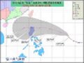
Multi-model:

Euro 12z 21 July:

This is the one shown in the 00z run by ECM, and by the way this image and the image above are some kind of simplified tracking map.

0 likes
Personal Forecast Disclaimer:
The posts in this forum are NOT official forecast and should not be used as such. They are just the opinion of the poster and may or may not be backed by sound meteorological data. They are NOT endorsed by any professional institution or storm2k.org. For official information, please refer to the NHC and NWS products.
The posts in this forum are NOT official forecast and should not be used as such. They are just the opinion of the poster and may or may not be backed by sound meteorological data. They are NOT endorsed by any professional institution or storm2k.org. For official information, please refer to the NHC and NWS products.
-
dexterlabio
- Category 5
- Posts: 3506
- Joined: Sat Oct 24, 2009 11:50 pm
This is posted along with the final advisory on Ma-on by JTWC. Though this one is located nearer Visayas islands.
B. TROPICAL DISTURBANCE SUMMARY:
(1) AN AREA OF CONVECTION HAS DEVELOPED NEAR 10.3N 128.5E,
APPROXIMATELY 265 NM EAST OF CEBU, PHILIPPINES, AND IS SHOWING
POTENTIAL FOR DEVELOPMENT OVER THE LONG TERM. THE LOW LEVEL
CIRCULATION CENTER (LLCC) IS CURRENTLY POORLY DEFINED ON ANIMATED
SATELLITE IMAGERY, BUT THE 220000Z PGTW STREAMLINE ANALYSIS REVEALS
A CLOSED CIRCULATION. THE LLCC EXISTS WITHIN THE MONSOON TROUGH
UNDERNEATH APPROXIMATELY 15 KNOTS OF EASTERLY VERTICAL WIND SHEAR.
THE MONSOON TROUGH IS RAPIDLY BECOMING RE-ESTABLISHED OVER THE
PHILIPPINE SEA IN THE WAKE OF 08W. STEADY SOUTHWESTERLIES HAVE SET
IN ON PALAU AND ANIMATED MULTISPECTRAL IMAGERY SHOWS INCREASING
CONVECTION ON THE SOUTH SIDE OF THE TROUGH. A 212327Z SSMIS IMAGE
SHOWS BROAD, MODERATE CURVATURE ON THE POLEWARD SIDE OF THE TROUGH
AND DEEPENING CONVECTION ON THE SOUTHERN SIDE. MAXIMUM SUSTAINED
SURFACE WINDS ARE ESTIMATED AT 10 TO 15 KNOTS. MINIMUM SEA LEVEL
PRESSURE IS ESTIMATED TO BE NEAR 1008 MB. THE POTENTIAL FOR THE
DEVELOPMENT OF A SIGNIFICANT TROPICAL CYCLONE WITHIN THE NEXT 24
HOURS IS LOW.
0 likes
Personal Forecast Disclaimer:
The posts in this forum are NOT official forecast and should not be used as such. They are just the opinion of the poster and may or may not be backed by sound meteorological data. They are NOT endorsed by any professional institution or storm2k.org. For official information, please refer to the NHC and NWS products.
The posts in this forum are NOT official forecast and should not be used as such. They are just the opinion of the poster and may or may not be backed by sound meteorological data. They are NOT endorsed by any professional institution or storm2k.org. For official information, please refer to the NHC and NWS products.
-
dexterlabio
- Category 5
- Posts: 3506
- Joined: Sat Oct 24, 2009 11:50 pm
Re:
StormingB81 wrote:True well see if it develops first..I mean Ma-on when being forecasted by the models was being brough to Okinawa nad never really touched us when it was time..so always have to wait and see
I'm sorry but I thought Ma-on did pass near Okinawa before going north towards Honshu?
Last edited by dexterlabio on Fri Jul 22, 2011 1:30 am, edited 2 times in total.
0 likes
Personal Forecast Disclaimer:
The posts in this forum are NOT official forecast and should not be used as such. They are just the opinion of the poster and may or may not be backed by sound meteorological data. They are NOT endorsed by any professional institution or storm2k.org. For official information, please refer to the NHC and NWS products.
The posts in this forum are NOT official forecast and should not be used as such. They are just the opinion of the poster and may or may not be backed by sound meteorological data. They are NOT endorsed by any professional institution or storm2k.org. For official information, please refer to the NHC and NWS products.
-
phwxenthusiast
- Category 2

- Posts: 637
- Joined: Wed Mar 24, 2010 3:10 am
- Location: Holbrook, NY (Long Island)
-
dexterlabio
- Category 5
- Posts: 3506
- Joined: Sat Oct 24, 2009 11:50 pm
Re: WPAC: INVEST 93W
Here:
http://www.emc.ncep.noaa.gov/mmb/gplou/emchurr/glblgen/
Everything I need is in there. NOGAPS, GFS, ECM, CMC, among others. It also updates shortly when the latest runs are posted.
http://www.emc.ncep.noaa.gov/mmb/gplou/emchurr/glblgen/
Everything I need is in there.
0 likes
Personal Forecast Disclaimer:
The posts in this forum are NOT official forecast and should not be used as such. They are just the opinion of the poster and may or may not be backed by sound meteorological data. They are NOT endorsed by any professional institution or storm2k.org. For official information, please refer to the NHC and NWS products.
The posts in this forum are NOT official forecast and should not be used as such. They are just the opinion of the poster and may or may not be backed by sound meteorological data. They are NOT endorsed by any professional institution or storm2k.org. For official information, please refer to the NHC and NWS products.
-
phwxenthusiast
- Category 2
- Posts: 637
- Joined: Wed Mar 24, 2010 3:10 am
- Location: Holbrook, NY (Long Island)
-
StormingB81
- S2K Supporter
- Posts: 5676
- Age: 44
- Joined: Thu Aug 27, 2009 1:45 am
- Location: Rockledge, Florida
Re: Re:
dexterlabio wrote:StormingB81 wrote:True well see if it develops first..I mean Ma-on when being forecasted by the models was being brough to Okinawa nad never really touched us when it was time..so always have to wait and see
I'm sorry but I thought Ma-on did pass near Okinawa before going north towards Honshu?Not a direct hit but just went near Okinawa and also various models including ECM have been hinting that it would make landfall over Southern Japan, the only upset on the early forecasts is that Ma-on weakened quickly instead of intensifying further as it passed south of Japan.
What I meant is at first it had it coming here then moved north and east the nodels did.....I know we had a brush of it I was aying it wasnt as bad as the models first said it would be but the are exactly that models and predictions that will always change
0 likes
-
dexterlabio
- Category 5
- Posts: 3506
- Joined: Sat Oct 24, 2009 11:50 pm
Re: Re:
StormingB81 wrote:
What I meant is at first it had it coming here then moved north and east the nodels did.....I know we had a brush of it I was aying it wasnt as bad as the models first said it would be but the are exactly that models and predictions that will always change
Oh I see.
0 likes
Personal Forecast Disclaimer:
The posts in this forum are NOT official forecast and should not be used as such. They are just the opinion of the poster and may or may not be backed by sound meteorological data. They are NOT endorsed by any professional institution or storm2k.org. For official information, please refer to the NHC and NWS products.
The posts in this forum are NOT official forecast and should not be used as such. They are just the opinion of the poster and may or may not be backed by sound meteorological data. They are NOT endorsed by any professional institution or storm2k.org. For official information, please refer to the NHC and NWS products.
-
RobWESTPACWX
- WestPACMet

- Posts: 1616
- Joined: Fri Sep 17, 2010 2:26 am
- Location: Tokyo, Japan
- Contact:
Re: WPAC: INVEST 93W
Last night 12Z run, in a consensus of something developing. All be it not to strong.

0 likes
Satellites, Charts and Forecasting tools for East Asia at WESTERNPACIFICWEATHER.COM
-
StormingB81
- S2K Supporter
- Posts: 5676
- Age: 44
- Joined: Thu Aug 27, 2009 1:45 am
- Location: Rockledge, Florida

Re: WPAC: INVEST 93W
HKO shows something happening in 72hrs, but doesnt look much, just a LPA? Probably just bring a lot of rain to Philippines which is a shame cause heard norther Philippines has had hell of a lot of rain this year
http://www.hko.gov.hk/nhm/nhmsfcpp72e.htm
http://www.hko.gov.hk/nhm/nhmsfcpp72e.htm
0 likes
Who is online
Users browsing this forum: No registered users and 14 guests