
Pouch 07L approaching Lesser Antilles - (Is invest 90L)
Moderator: S2k Moderators
Forum rules

The posts in this forum are NOT official forecasts and should not be used as such. They are just the opinion of the poster and may or may not be backed by sound meteorological data. They are NOT endorsed by any professional institution or STORM2K. For official information, please refer to products from the National Hurricane Center and National Weather Service.
-
SouthFloridawx

- S2K Supporter

- Posts: 8346
- Age: 47
- Joined: Tue Jul 26, 2005 1:16 am
- Location: Sarasota, FL
- Contact:
-
South Texas Storms

- Professional-Met

- Posts: 4246
- Joined: Thu Jun 24, 2010 12:28 am
- Location: Houston, TX
Re: Pouch PO7L east of Lesser Antilles - 10%
It looks like tonight's 0z NAM run develops it just north of Cuba in 84 hours.
0 likes

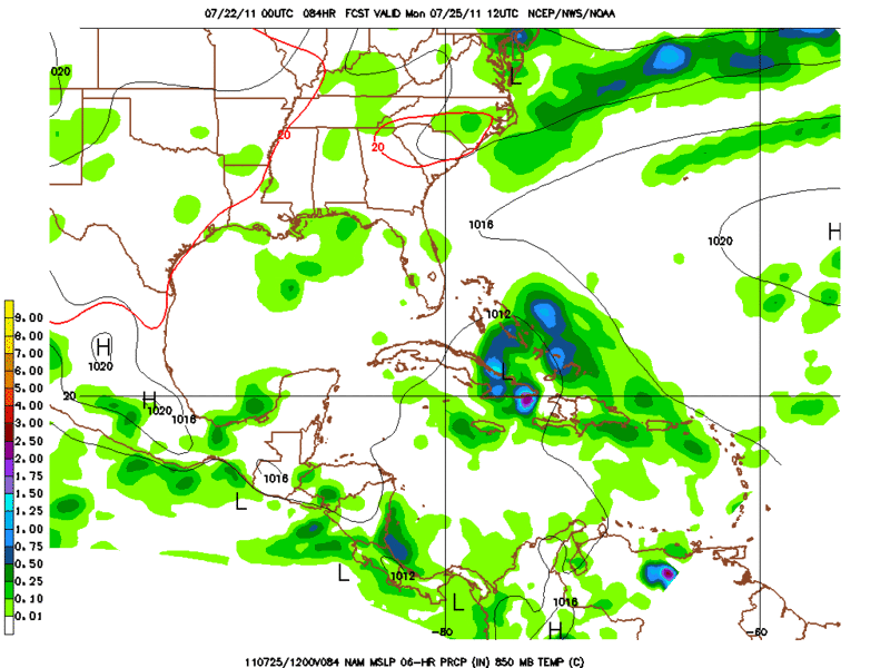
00Z model suite coming in....First up FWIW Nam...
Further West than prior runs and looks gulf bound per latest guidance...Analysis of the 00Z NAM indicates overall envelope should really begin to expand in aerial coverage and intensity over the next 24 hours...It would appear very squally weather is on tap for the leewaed islands, PR, and DR..In fact, with a decent gradient setting up I'm expecting localized gusts to minimal TS across the region even it it holds off on classification..I think if it maintains itself than just N of Haiti/bahamas is where we close off the system and get a possible upgrade....
00Z 7/22 Nam Loop:
http://www.nco.ncep.noaa.gov/pmb/nwprod ... loop.shtml
0 likes
-
South Texas Storms
- Professional-Met
- Posts: 4246
- Joined: Thu Jun 24, 2010 12:28 am
- Location: Houston, TX
Re: Pouch PO7L east of Lesser Antilles - 10%
It will be interesting to see if the 0z CMC hops back on with development and if the 0z Euro keeps it too.
0 likes
-
Rgv20

- S2K Supporter
- Posts: 2466
- Age: 39
- Joined: Wed Jan 05, 2011 5:42 pm
- Location: Edinburg/McAllen Tx
I actually agree with tonight's 0zNam on the handling of the Tropical Wave even though it may be to fast with the forward speed of the wave.
At 84hrs 0zNam has the wave just north of Cuba, my thinking would be just north of Haiti.
At 84hrs 0zNam has the wave just north of Cuba, my thinking would be just north of Haiti.
0 likes
The following post is NOT an official forecast and should not be used as such. It is just the opinion of the poster and may or may not be backed by sound meteorological data. It is NOT endorsed by any professional institution including storm2k.org For Official Information please refer to the NHC and NWS products.
-
South Texas Storms
- Professional-Met
- Posts: 4246
- Joined: Thu Jun 24, 2010 12:28 am
- Location: Houston, TX
Re: Pouch PO7L east of Lesser Antilles - 10%
I don't really agree with the GFS. Tonight's 0z run continues to show no development. It seems like it doesn't even see the wave very well.
0 likes
-
SFLcane

- S2K Supporter
- Posts: 10281
- Age: 48
- Joined: Sat Jun 05, 2010 1:44 pm
- Location: Lake Worth Florida
Re: Pouch PO7L east of Lesser Antilles - 10%
I still dont see much in the way of development with this TW anytime soon. The overall environment that is ahead is not to friendly to say the least as it may run into possible land interaction and a TUTT like feature.
0 likes
-
Brent
- S2K Supporter
- Posts: 38484
- Age: 37
- Joined: Sun May 16, 2004 10:30 pm
- Location: Tulsa Oklahoma
- Contact:
Re: Pouch PO7L east of Lesser Antilles - 10%
TROPICAL WEATHER OUTLOOK
NWS NATIONAL HURRICANE CENTER MIAMI FL
200 AM EDT FRI JUL 22 2011
FOR THE NORTH ATLANTIC...CARIBBEAN SEA AND THE GULF OF MEXICO...
THE NATIONAL HURRICANE CENTER IS ISSUING ADVISORIES ON TROPICAL
STORM CINDY...LOCATED ABOUT 910 MILES WEST-NORTHWEST OF THE
AZORES. ADVISORIES ARE ALSO BEING ISSUED ON TROPICAL STORM
BRET...LOCATED ABOUT 295 MILES NORTHWEST OF BERMUDA.
A TROPICAL WAVE LOCATED ABOUT 500 MILES EAST OF THE WINDWARD ISLANDS
IS PRODUCING SCATTERED SHOWERS AND A FEW THUNDERSTORMS. UPPER-LEVEL
WINDS ARE EXPECTED TO GRADUALLY BECOME A LITTLE MORE CONDUCIVE FOR
SOME SLOW DEVELOPMENT OF THIS DISTURBANCE OVER THE NEXT COUPLE OF
DAYS. THIS SYSTEM HAS A LOW CHANCE...20 PERCENT...OF BECOMING A
TROPICAL CYCLONE DURING THE NEXT 48 HOURS AS IT MOVES TOWARD THE
WEST-NORTHWEST AT 15 TO 20 MPH. REGARDLESS OF DEVELOPMENT...BRIEF
PERIODS OF LOCALLY HEAVY RAINFALL AND GUSTY WINDS ASSOCIATED WITH
THIS WAVE COULD BEGIN SPREADING ACROSS PORTIONS OF THE LESSER
ANTILLES THIS AFTERNOON AND INTO TONIGHT.
ELSEWHERE...TROPICAL CYCLONE FORMATION IS NOT EXPECTED DURING THE
NEXT 48 HOURS.
$$
FORECASTER STEWART
0 likes
#neversummer
-
SouthFloridawx
- S2K Supporter
- Posts: 8346
- Age: 47
- Joined: Tue Jul 26, 2005 1:16 am
- Location: Sarasota, FL
- Contact:
-
HurricaneBrain

- S2K Supporter
- Posts: 520
- Joined: Thu Jun 30, 2011 2:07 pm

-
cycloneye

- Admin

- Posts: 148733
- Age: 69
- Joined: Thu Oct 10, 2002 10:54 am
- Location: San Juan, Puerto Rico
Re: Pouch PO7L east of Lesser Antilles - 20%
This morning's discussion of wave by Crown Weather Services:
http://www.crownweather.com/?page_id=4557
http://www.crownweather.com/?page_id=4557
Tropical Wave Located 500 Miles East Of The Windward Islands:
I am closely watching a tropical wave that is located around 500 miles to the east of the Windward Islands this morning. This tropical wave is producing on and off popcorn type shower and thunderstorm activity, where it fires up for several hours and then weakens thereafter. The reason for the lack of deep, sustained convection is that there continues to be a large amount of dry, dusty air from the Sahara of Africa.
This tropical wave is expected to continue tracking west-northwestward this weekend into next week and will bring some very squally weather to the northern Lesser Antilles and Puerto Rico from Saturday into Sunday with heavy rainfall and gusty winds to 40 to 50 mph expected.
Even though vertical wind shear values are low enough to support tropical development, the dry, dusty air near this tropical wave will prevent it from developing into a tropical cyclone. Water vapor satellite loops indicate that the atmosphere is moister near the Bahamas and it is possible that this tropical wave may try to develop into a tropical cyclone once it reaches the Bahamas on Monday and Tuesday; although, this is not a sure thing. Only the NOGAPS model is forecasting development into a tropical cyclone during the early and middle part of next week. All of the other global model guidance members are saying no to development.
At this point, I think it is going to be a pretty much wait and see game for the next several days. I will say I do not expect tropical cyclone development from this tropical wave from today through Sunday night with the first chance of possible development arriving during Monday and Tuesday. Either way, I will keep a close eye on this tropical wave and will keep you all updated on the latest.
0 likes
Visit the Caribbean-Central America Weather Thread where you can find at first post web cams,radars
and observations from Caribbean basin members Click Here
and observations from Caribbean basin members Click Here

SFLcane wrote:I still dont see much in the way of development with this TW anytime soon. The overall environment that is ahead is not to friendly to say the least as it may run into possible land interaction and a TUTT like feature.
Its one of those systems that does need watching, providing it can lift north of the islands its going to at least have a shot at weak development. The models aren't overly agressive anymore though so whilst something may develop, odds on it'll be like Bonnie 2010 or something like that.
0 likes
Personal Forecast Disclaimer:
The posts in this forum are NOT official forecast and should not be used as such. They are just the opinion of the poster and may or may not be backed by sound meteorological data. They are NOT endorsed by any professional institution or storm2k.org. For official information, please refer to the NHC and NWS products
The posts in this forum are NOT official forecast and should not be used as such. They are just the opinion of the poster and may or may not be backed by sound meteorological data. They are NOT endorsed by any professional institution or storm2k.org. For official information, please refer to the NHC and NWS products
-
Blown Away

- S2K Supporter
- Posts: 10253
- Joined: Wed May 26, 2004 6:17 am
Re: Pouch PO7L east of Lesser Antilles - 20%
The one spot that has maintained a decent convection blob since yesterday is up near 18N/54W, I keep thinking if a LLC develops it will be below 15N, but maybe it will be up near 18N?
http://www.ssd.noaa.gov/goes/east/catl/loop-avn.html
http://www.ssd.noaa.gov/goes/east/catl/loop-avn.html
0 likes
Hurricane Eye Experience: David 79, Irene 99, Frances 04, Jeanne 04, Wilma 05… Hurricane Brush Experience: Andrew 92, Erin 95, Floyd 99, Matthew 16, Irma 17, Ian 22, Nicole 22…


-
Gustywind

- Category 5

- Posts: 12334
- Joined: Mon Sep 03, 2007 7:29 am
- Location: Baie-Mahault, GUADELOUPE
000
AXNT20 KNHC 221100
TWDAT
TROPICAL WEATHER DISCUSSION
NWS NATIONAL HURRICANE CENTER MIAMI FL
805 AM EDT FRI JUL 22 2011
TROPICAL WEATHER DISCUSSION FOR NORTH AMERICA...CENTRAL
AMERICA...GULF OF MEXICO...CARIBBEAN SEA...NORTHERN SECTIONS
OF SOUTH AMERICA...AND ATLANTIC OCEAN TO THE AFRICAN COAST
FROM THE EQUATOR TO 32N. THE FOLLOWING INFORMATION IS BASED
ON SATELLITE IMAGERY...WEATHER OBSERVATIONS...RADAR...AND
METEOROLOGICAL ANALYSIS.
BASED ON 0600 UTC SURFACE ANALYSIS AND SATELLITE IMAGERY
THROUGH 1015 UTC.
...TROPICAL WAVES...
AN ATLANTIC OCEAN TROPICAL WAVE IS ALONG 18N52W 13N54W 9N54W.
WIDELY SCATTERED TO SCATTERED MODERATE RAINSHOWERS AND ISOLATED
STRONG THUNDERSTORMS ARE FROM 11N TO 20N BETWEEN 50W AND 60W.
$$
MT
0 likes

-
cycloneye
- Admin
- Posts: 148733
- Age: 69
- Joined: Thu Oct 10, 2002 10:54 am
- Location: San Juan, Puerto Rico
Re: Pouch 07L approaching Lesser Antilles - 20%
TROPICAL WEATHER OUTLOOK...CORRECTED
NWS NATIONAL HURRICANE CENTER MIAMI FL
800 AM EDT FRI JUL 22 2011
FOR THE NORTH ATLANTIC...CARIBBEAN SEA AND THE GULF OF MEXICO...
THE NATIONAL HURRICANE CENTER IS ISSUING ADVISORIES ON TROPICAL
STORM CINDY...LOCATED ABOUT 910 MILES WEST-NORTHWEST OF THE
AZORES. ADVISORIES ARE ALSO BEING ISSUED ON RECENTLY DOWNGRADED
TROPICAL DEPRESSION BRET...LOCATED ABOUT 295 MILES NORTHWEST OF
BERMUDA.
A TROPICAL WAVE LOCATED ABOUT 500 MILES EAST OF THE WINDWARD ISLANDS
IS PRODUCING SCATTERED SHOWERS AND A FEW THUNDERSTORMS. UPPER-LEVEL
WINDS ARE EXPECTED TO GRADUALLY BECOME A LITTLE MORE CONDUCIVE FOR
SOME SLOW DEVELOPMENT OF THIS DISTURBANCE OVER THE NEXT COUPLE OF
DAYS. THIS SYSTEM HAS A LOW CHANCE...20 PERCENT...OF BECOMING A
TROPICAL CYCLONE DURING THE NEXT 48 HOURS AS IT MOVES TOWARD THE
WEST-NORTHWEST AT 15 TO 20 MPH. REGARDLESS OF DEVELOPMENT...BRIEF
PERIODS OF LOCALLY HEAVY RAINFALL AND GUSTY WINDS ASSOCIATED WITH
THIS WAVE COULD BEGIN SPREADING ACROSS PORTIONS OF THE LESSER
ANTILLES THIS AFTERNOON AND INTO TONIGHT.
ELSEWHERE...TROPICAL CYCLONE FORMATION IS NOT EXPECTED DURING THE
NEXT 48 HOURS.
$$
FORECASTER STEWART
0 likes
Visit the Caribbean-Central America Weather Thread where you can find at first post web cams,radars
and observations from Caribbean basin members Click Here
and observations from Caribbean basin members Click Here
Who is online
Users browsing this forum: Google [Bot] and 41 guests