NWS in Brownsville keeping a close eye on 90l
Today's afternoons discussion
.LONG TERM /MONDAY THROUGH SATURDAY/...THE LONGER RANGE GFS AND
ECMWF GUIDANCE HAS SHIFTED A BIT IN THE EXPECTED WEAKENING OF THE
500 MB RIDGING CURRENTLY IN PLACE OVER THE LOWER 48 STATES WITH
BOTH OF THE MODELS REFLECTING A BROADER AND MORE EASTWARD PLACED
WEAKNESS IN THE RIDGING. THIS MORE EASTWARD POSITIONING OF THE MID
LEVEL WEAKNESS MAKES FOR A MORE PESSIMISTIC RAIN FORECAST IN THE
3 TO 7 DAY RANGE AS MOST OF THE DEEPER MOISTURE STILL REMAINS
POOLED TOO FAR TO THE EAST OF THE REGION TO PRODUCE MUCH HOPE FOR
CONV. HOWEVER ANOTHER FEATURE OF INTEREST FOR DEEP SOUTH TX IS THE
TROPICAL WAVE CURRENTLY LOCATED OVER THE LEEWARD ISLANDS. MODEL
GUIDANCE AND GUIDANCE FROM HPC/NHC SHOWS THAT THIS WAVE WILL
LIKELY MOVE INTO THE GULF OF MEX NEXT WED/THUR EVENTUALLY
APPROACHING THE TX COASTLINE NEXT SAT. MORE SIGNIFICANT TROPICAL
MOISTURE ASSOCIATED WITH THIS WAVE MAY BEGIN TO EDGE INTO DEEP
SOUTH TX AS NEXT WEEKEND APPROACHES POSSIBLY SETTING THE STAGE FOR
SOME BETTER CONV CHCS BY THE END OF THIS COMING WEEK. FOR NOW WILL
GO A LITTLE MORE CONSERVATIVE THAN THE GFS MEX POPS AT THE END OF
THE FORECAST PERIOD DUE TO THE UNCERTAINTY OF THE FINAL TRACK OF
THE WAVE. CURRENTLY IR SATL IMAGERY SHOWS THAT THIS FEATURE IS
FAIRLY DISORGANIZED AND NHC IS GIVING IT ONLY A 10 PERCENT CHANCE
OF SOME DEVELOPMENT OVER THE NEXT 48 HOURS. DESPITE THIS...
RESIDENTS OF DEEP SOUTH TX SHOULD STAY TUNED TO THE LATEST
TROPICAL WEATHER OUTLOOK FROM NHC CONCERNING THE PROGRESS OF THIS
FEATURE.
ATL: DON - Remnant - Discussion
Moderator: S2k Moderators
-
Rgv20

- S2K Supporter

- Posts: 2466
- Age: 39
- Joined: Wed Jan 05, 2011 5:42 pm
- Location: Edinburg/McAllen Tx
0 likes
The following post is NOT an official forecast and should not be used as such. It is just the opinion of the poster and may or may not be backed by sound meteorological data. It is NOT endorsed by any professional institution including storm2k.org For Official Information please refer to the NHC and NWS products.
-
cycloneye

- Admin

- Posts: 149249
- Age: 69
- Joined: Thu Oct 10, 2002 10:54 am
- Location: San Juan, Puerto Rico
Re: ATL: INVEST 90L - Discussion
Here is what all see in sat pics with the clouds but here is the long range radar of San Juan that shows all the rain and some squalls.

0 likes
Visit the Caribbean-Central America Weather Thread where you can find at first post web cams,radars
and observations from Caribbean basin members Click Here
and observations from Caribbean basin members Click Here

Re: ATL: INVEST 90L - Discussion
Ivanhater wrote:Wxman looks spot on. Convection is not a problem, the issue is the strong easterly flow over the eastern Caribbean right now not allowing a surface circulation to form. Once this slows in the Western Caribbean, the convection will be allowed to pop a surface low.
This is one of the main reasons that the eastern Caribbean is known as a dead zone for tropical cyclone development. A storm with a well-developed circulation is not affected much by the strong easterly flow, but a system without a circulation usually cannot develop one with such a strong flow.
0 likes
-
gatorcane

- S2K Supporter
- Posts: 23708
- Age: 48
- Joined: Sun Mar 13, 2005 3:54 pm
- Location: Boca Raton, FL
Re: Re:
Rgv20 wrote:gatorcane wrote:The posts in this forum are NOT official forecast and should not be used as such. They are just the opinion of the poster and may or may not be backed by sound meteorological data. They are NOT endorsed by any professional institution or storm2k.org. For official information, please refer to the NHC and NWS products.
Looks like development chances are going down by the hour especially because land interaction is going to be an issue plus the shear is on the increase now.
In the end the problem was the fact there was too much dry air and dust around when it was east of the Leewards which is expected in July though.
So far it's behaving about as I expected, though it has gotten a bit more north than I thought.
At any rate probably will end up just being another tropical wave that does not develop in the end.
Another win for the GFS over the ECMWF this year it looks like.
Keyword is it has behave as expected, could still be a player down the road in the GOM. Only one comment regarding GFS vs ECMWF, I never take a model run literally Its best to use a blend of ECMWF, GFS, UKMET, CMC. And besides we all know ECMWF is a superior model to the GFS...

True, cannot rule out the Western Caribbean possibility. But we do have several days before it gets there.
GFS does nothing with it there but notice the HWRF and GFDL do.
That said, the latter models are better when we actually have a consolidated system so would put my money on the global models like the GFS right now instead.
Last edited by gatorcane on Sat Jul 23, 2011 3:54 pm, edited 1 time in total.
0 likes
-
StormClouds63
- Category 2

- Posts: 583
- Age: 62
- Joined: Tue May 13, 2008 11:56 am
- Location: Southwest Louisiana
Re: ATL: INVEST 90L - Discussion
I trust Wxman57 as well ... let's see what happens early next week.
0 likes

Could well yet be a player down the road as wxman57 said, in which case it'd be a very similar sort of system to Dolly, where it was convectivly active but could never quite pull a circulation to the surface...then again Dolly was light years ahead of 90L in terms of development by this point from what I remember...so maybe a weaker version of Dolly coming up?
0 likes
Personal Forecast Disclaimer:
The posts in this forum are NOT official forecast and should not be used as such. They are just the opinion of the poster and may or may not be backed by sound meteorological data. They are NOT endorsed by any professional institution or storm2k.org. For official information, please refer to the NHC and NWS products
The posts in this forum are NOT official forecast and should not be used as such. They are just the opinion of the poster and may or may not be backed by sound meteorological data. They are NOT endorsed by any professional institution or storm2k.org. For official information, please refer to the NHC and NWS products
-
cycloneye
- Admin
- Posts: 149249
- Age: 69
- Joined: Thu Oct 10, 2002 10:54 am
- Location: San Juan, Puerto Rico
Re:
KWT wrote:Could well yet be a player down the road as wxman57 said, in which case it'd be a very similar sort of system to Dolly, where it was convectivly active but could never quite pull a circulation to the surface...then again Dolly was light years ahead of 90L in terms of development by this point from what I remember...so maybe a weaker version of Dolly coming up?
Here is Dolly's track and look where it started as a TS.

0 likes
Visit the Caribbean-Central America Weather Thread where you can find at first post web cams,radars
and observations from Caribbean basin members Click Here
and observations from Caribbean basin members Click Here


-
Rgv20
- S2K Supporter
- Posts: 2466
- Age: 39
- Joined: Wed Jan 05, 2011 5:42 pm
- Location: Edinburg/McAllen Tx
Nam still develops 90l, it has a closed low by 72hrs. I agree with this scenario from the Nam as it looks like Tuesday should be the day that it really gets going. As far as placement of the low by Tuesday maybe just a tad south as to what the Nam is showing.
18zNam valid 18zTuesday
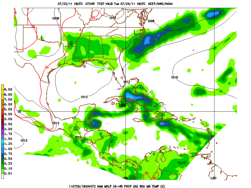
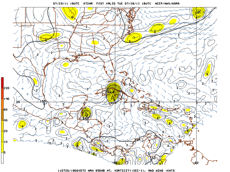
18zNam valid 18zTuesday
0 likes
The following post is NOT an official forecast and should not be used as such. It is just the opinion of the poster and may or may not be backed by sound meteorological data. It is NOT endorsed by any professional institution including storm2k.org For Official Information please refer to the NHC and NWS products.
-
Weatherfreak000
Re: ATL: INVEST 90L - Discussion
wxman57 wrote:I think that development chances next 48 hours are minimal, perhaps 5%. But wait until it reaches the NW Caribbean in 3 days when convergence increases. That's when development chances go up considerably (Monday night/Tue). Recon may well be needed by Monday afternoon.
Great thoughts here. I personally find it easy to forget how conducive convective flareups can be near the Lesser Antilles where this invest popped up because the season it early but it happens very often. Almost as often as they pop up though eventually when they reach the graveyard they struggle. lol.
0 likes

Re: ATL: INVEST 90L - Discussion
Ivanhater wrote:Wxman looks spot on. Convection is not a problem, the issue is the strong easterly flow over the eastern Caribbean right now not allowing a surface circulation to form. Once this slows in the Western Caribbean, the convection will be allowed to pop a surface low.
"pop a surface low"...very nice Michael...
0 likes
Re: ATL: INVEST 90L - Discussion

look at Allen....what a beast....
even Ivan back then had a jacked up track...
0 likes
-
vbhoutex

- Storm2k Executive
- Posts: 29144
- Age: 74
- Joined: Wed Oct 09, 2002 11:31 pm
- Location: Cypress, TX
- Contact:
Re: Re:
chrisnnavarre wrote:ROCK wrote:chrisnnavarre wrote:Even with the shear, it sure looks like it's coming together around 16N 64W...just saying...if it stays south of the islands this could be our first major player into the Western Caribbean this season.
Not even close...look below the convection as its being sheared out to the NE....low level to mid level vorticty...around 15N 65W...speed it up....
http://rammb.cira.colostate.edu/ramsdis ... opical.asp
Yep, I see the shear too. Still looks like a circulation down there, and convection is increasing. Anyone know what the nearest pressure readings are now? Is there a weather station near by, or a buoy perhaps?
I don't see anything approaching a circulation yet. I do see exploding convection and blow off from shear. I have no doubt 90L will be a player down the road as long as it stays on the course it is on now keeping South of the islands. Hispaniola's highest mountains are on it's South side if I remember correctly so they should continue to disrupt any attempts at developing a circulation till it is past the island.
Does anyone see a chance the Northern part of the wave axis will develop as opposed to the Southern end?
0 likes
Skywarn, C.E.R.T.
Please click below to donate to STORM2K to help with the expenses of keeping the site going:

Please click below to donate to STORM2K to help with the expenses of keeping the site going:
Re: ATL: INVEST 90L - Models
with the ridge reloading after the trof moves thru a MX landfall is not out of the question. Really depends on where the surface low sets up shop (if ever) and how strong the NGOM death ridge is.
0 likes
-
South Texas Storms

- Professional-Met

- Posts: 4256
- Joined: Thu Jun 24, 2010 12:28 am
- Location: Houston, TX
Re: ATL: INVEST 90L - Models
ROCK wrote:with the ridge reloading after the trof moves thru a MX landfall is not out of the question. Really depends on where the surface low sets up shop (if ever) and how strong the NGOM death ridge is.
ROCK the ridge is forecast to weaken and move east of TX by the time this wave gets in the western Gulf according to the afternoon AFD from NWS Corpus Christi today: "THE MAIN QUESTION IS THE MOVEMENT OF THE TROPICAL
DISTURBANCE CURRENTLY LOCATED ACROSS THE LEEWARD ISLANDS. THE
FORECAST MODELS KEEP AN OPEN WAVE AS THE DISTURBANCE MOVES CLOSER TO
THE TEXAS COAST BY LATE NEXT WEEK...BRINGING ABUNDANT ATMOSPHERIC
MOISTURE. THE HIGH PRESSURE ALOFT IS EXPECTED TO WEAKEN DURING THIS
TIMEFRAME SHIFTING EASTWARD...ALLOWING THE DISTURBANCE TO MOVE IN
ACROSS SOUTHEAST AND PORTIONS OF SOUTH TEXAS. FOR NOW...WILL
CONTINUE THE SLIGHT CHANCE POPS."
0 likes
Re: ATL: INVEST 90L - Discussion
VB I see nothing at the surface rather mid level rotation to the south of PR with the convection being sheared off to the NE......center relocation are always an issue with a developing TC especially one being sheared as much as 90L is....I am looking to the south...
0 likes
Re: ATL: INVEST 90L - Models
South Texas Storms wrote:ROCK wrote:with the ridge reloading after the trof moves thru a MX landfall is not out of the question. Really depends on where the surface low sets up shop (if ever) and how strong the NGOM death ridge is.
ROCK the ridge is forecast to weaken and move east of TX by the time this wave gets in the western Gulf according to the afternoon AFD from NWS Corpus Christi today: "THE MAIN QUESTION IS THE MOVEMENT OF THE TROPICAL
DISTURBANCE CURRENTLY LOCATED ACROSS THE LEEWARD ISLANDS. THE
FORECAST MODELS KEEP AN OPEN WAVE AS THE DISTURBANCE MOVES CLOSER TO
THE TEXAS COAST BY LATE NEXT WEEK...BRINGING ABUNDANT ATMOSPHERIC
MOISTURE. THE HIGH PRESSURE ALOFT IS EXPECTED TO WEAKEN DURING THIS
TIMEFRAME SHIFTING EASTWARD...ALLOWING THE DISTURBANCE TO MOVE IN
ACROSS SOUTHEAST AND PORTIONS OF SOUTH TEXAS. FOR NOW...WILL
CONTINUE THE SLIGHT CHANCE POPS."
timing will be everything with this guy....MX to FL is where I am watching....
0 likes
Re: ATL: INVEST 90L - Discussion
http://rammb.cira.colostate.edu/ramsdis ... opical.asp
VB speed this guy up and look to the south of PR.....see the mid level rotation and the blow up of convection. Then this area seems to tuck up under the new blow up....thats the area I have been watching...
VB speed this guy up and look to the south of PR.....see the mid level rotation and the blow up of convection. Then this area seems to tuck up under the new blow up....thats the area I have been watching...
0 likes
-
HouTXmetro

- Category 5

- Posts: 3949
- Joined: Sun Jun 13, 2004 6:00 pm
- Location: District of Columbia, USA
Re: ATL: INVEST 90L - Models
Well My current thinking is if something get's going then Mexico too Rock. Of the the situations is fluid but that last set of models were in tight agreement for a West to WNW moving system in the South Central Gulf...But that Corpus discussion does perk may attention..thanks for posting STS
0 likes
[Disclaimer: My Amateur Opinion, please defer to your local authorities or the NHC for Guidance.]
-
southerngale

- Retired Staff

- Posts: 27418
- Joined: Thu Oct 10, 2002 1:27 am
- Location: Southeast Texas (Beaumont area)

 my Cowboys
 Who is online
Users browsing this forum: No registered users and 7 guests