WV loop
http://www.ssd.noaa.gov/goes/east/watl/flash-wv.html
Shear chart
Mid Shear
Moderator: S2k Moderators

ROCK wrote:http://rammb.cira.colostate.edu/ramsdis/online/tropical.asp
VB speed this guy up and look to the south of PR.....see the mid level rotation and the blow up of convection. Then this area seems to tuck up under the new blow up....thats the area I have been watching...


South Texas Storms wrote:On the latest satellite imagery, it looks like this system is a big squall line moving SW away from Puerto Rico right now.

cycloneye wrote:South Texas Storms wrote:On the latest satellite imagery, it looks like this system is a big squall line moving SW away from Puerto Rico right now.
Speaking of squalls,I am as I type this post under a squally weather with heavy rain with thunder,lighting and pretty strong gusts,that in my view are in the range of 30-35 mph.Also,power has been intermitent.


South Texas Storms wrote:ROCK wrote:with the ridge reloading after the trof moves thru a MX landfall is not out of the question. Really depends on where the surface low sets up shop (if ever) and how strong the NGOM death ridge is.
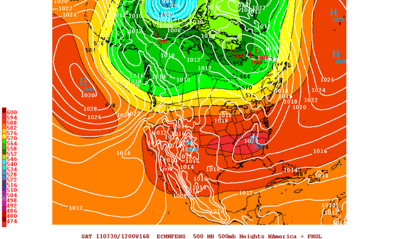
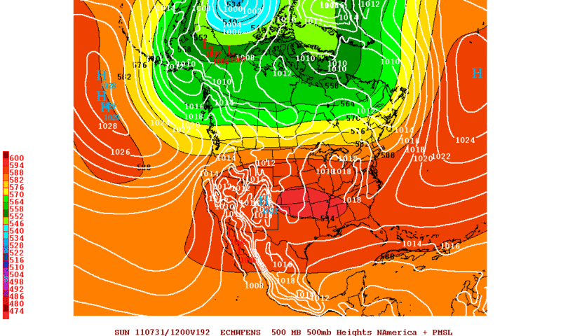
ROCK the ridge is forecast to weaken and move east of TX by the time this wave gets in the western Gulf according to the afternoon AFD from NWS Corpus Christi today: "THE MAIN QUESTION IS THE MOVEMENT OF THE TROPICAL
DISTURBANCE CURRENTLY LOCATED ACROSS THE LEEWARD ISLANDS. THE
FORECAST MODELS KEEP AN OPEN WAVE AS THE DISTURBANCE MOVES CLOSER TO
THE TEXAS COAST BY LATE NEXT WEEK...BRINGING ABUNDANT ATMOSPHERIC
MOISTURE. THE HIGH PRESSURE ALOFT IS EXPECTED TO WEAKEN DURING THIS
TIMEFRAME SHIFTING EASTWARD...ALLOWING THE DISTURBANCE TO MOVE IN
ACROSS SOUTHEAST AND PORTIONS OF SOUTH TEXAS. FOR NOW...WILL
CONTINUE THE SLIGHT CHANCE POPS."


stormreader wrote:BigA wrote:Seems to me that this has a better shot if it stays south of the Greater Antilles, given that UL conditions are more likely to be favorable in the W.Carib than the Bahamas in 48-72 hours.
The 12Z GFDL and HWRF runs, and the FOX WRF run http://weather.myfoxtampabay.com/maps/W ... shear.html seem to bear this out. It has to stay south of Hispaniola and Cuba to have a chance.
I think it will stay south of Haiti and Cuba. Just looking at latest loops from NHC, looks like llc is becoming more apparent at the southern end of that expanding mass of convection. Perhaps just my imagination. Maybe a closer look would tell.
http://www.ssd.noaa.gov/goes/east/tatl/flash-vis.html

Vortex wrote:taking into consideration the 18Z NAM for example the point that must be enphaziaed is the real potential for "extreme rainfall" amouts across potions of the greater antilles namely the DR and Cuba...The impacts from rainfall alone have the potential to bring about a devastating event over the next 48-72..... It will also likely slow considerably over the next 2-3 days as well....
18Z Nam loop:
http://www.nco.ncep.noaa.gov/pmb/nwprod ... loop.shtml


wxman57 wrote:I'd put it along 68W as of 6PM CDT, maybe 16N, but there is definitely no LLC yet. Just a wave axis. Convection is expanding and outflow improving. Note that 850mb winds in its immediate path increase to 25-30 kts, or more. Not good for near-term development, but those winds forecast to drop to 15 kts near the Yucatan. That is good for low-level convergence. GFS and Euro move the ridge over Texas east to the Carolinas by Thursday, opening up the western Gulf for a northerly turn toward TX if it does develop, or even if it doesn't develop.

flwxwatcher wrote:Vortex wrote:taking into consideration the 18Z NAM for example the point that must be enphaziaed is the real potential for "extreme rainfall" amouts across potions of the greater antilles namely the DR and Cuba...The impacts from rainfall alone have the potential to bring about a devastating event over the next 48-72..... It will also likely slow considerably over the next 2-3 days as well....
18Z Nam loop:
http://www.nco.ncep.noaa.gov/pmb/nwprod ... loop.shtml
It will intersting to see exactly were the main axis of the wave sets up down the road. I know everyone is talking about this in the W CARIB but the 12z EURO still shows this moving across the islands then emerging off of Cuba in the FL straits / Key west area and into the Gulf.
Users browsing this forum: No registered users and 35 guests