ATL: DON - Remnant - Discussion
Moderator: S2k Moderators
-
South Texas Storms

- Professional-Met

- Posts: 4256
- Joined: Thu Jun 24, 2010 12:28 am
- Location: Houston, TX
Re: ATL: INVEST 90L - Models
Why did they deactivate this invest? It still has the potential to develop in a few days.
0 likes
-
vbhoutex

- Storm2k Executive

- Posts: 29144
- Age: 74
- Joined: Wed Oct 09, 2002 11:31 pm
- Location: Cypress, TX
- Contact:
Re:
HurricaneWarning92 wrote:Hey everyone, im new to storm2k, and i apologize if i sound inexperienced but i sure will try my best. Anyway, i dont think 90L will develop much in the short term as some of you have said, due to land interaction.
Welcome to STORM2K. Feel free to ask questions and join in the discussions.
0 likes
Skywarn, C.E.R.T.
Please click below to donate to STORM2K to help with the expenses of keeping the site going:

Please click below to donate to STORM2K to help with the expenses of keeping the site going:

Re: ATL: INVEST 90L - Discussion
Huge d-min pulse. We'll see what the d-max brings tomorrow. Typical "Caribbean Zone" negativity.
0 likes
-
djones65
- Category 1

- Posts: 264
- Age: 60
- Joined: Mon Jun 20, 2005 12:05 am
- Location: Ocean Springs, MS
Re: ATL: INVEST 90L - Models
It hasn't been deactivated. The pasted info provided above was for 90L in March of this year. As of 0500 UTC 90L is still an active invest. At least as far as I can tell. The 00Z coordinates for July 24th 0000 UTC is 16.1N and 66.2W with 25kt winds and 1014 mb pressure.
The user who posted the deactivated 90L information was posting from four months ago and is not the current invest 90L.
The user who posted the deactivated 90L information was posting from four months ago and is not the current invest 90L.
0 likes
-
lester

- S2K Supporter

- Posts: 1305
- Age: 37
- Joined: Sat Aug 27, 2005 5:21 pm
- Location: Washington, DC
- Contact:
Re: Re: ATL: INVEST 90L - Models
djones65 wrote:It hasn't been deactivated. The pasted info provided above was for 90L in March of this year. As of 0500 UTC 90L is still an active invest. At least as far as I can tell. The 00Z coordinates for July 24th 0000 UTC is 16.1N and 66.2W with 25kt winds and 1014 mb pressure.
The user who posted the deactivated 90L information was posting from four months ago and is not the current invest 90L.
You're absolutely right..
http://ftp.nhc.noaa.gov/atcf/tcweb/inve ... 902011.ren
the deactivate file is from march's 90L after all
Sent from my ADR6300 using Tapatalk
0 likes
-
bamajammer4eva
- Category 4

- Posts: 907
- Joined: Sun Apr 18, 2010 3:21 am
- Location: Ozark, AL
Re: ATL: INVEST 90L - Models
djones65 wrote:It hasn't been deactivated. The pasted info provided above was for 90L in March of this year. As of 0500 UTC 90L is still an active invest. At least as far as I can tell. The 00Z coordinates for July 24th 0000 UTC is 16.1N and 66.2W with 25kt winds and 1014 mb pressure.
The user who posted the deactivated 90L information was posting from four months ago and is not the current invest 90L.
Sorry-didn't realize there was another 90 and when I posted that, there was nothing past 18z at this link ftp://ftp.nhc.noaa.gov/atcf/tcweb/inves ... 011.invest and most of that was zeroed out then.
0 likes

-
cycloneye

- Admin
- Posts: 149245
- Age: 69
- Joined: Thu Oct 10, 2002 10:54 am
- Location: San Juan, Puerto Rico
Re: ATL: INVEST 90L - Models
Invest 90L is still active as of this morning.However,no tropical model runs have been made since the 18z one of Saturday afternoon.
0 likes
Visit the Caribbean-Central America Weather Thread where you can find at first post web cams,radars
and observations from Caribbean basin members Click Here
and observations from Caribbean basin members Click Here

-
cycloneye
- Admin
- Posts: 149245
- Age: 69
- Joined: Thu Oct 10, 2002 10:54 am
- Location: San Juan, Puerto Rico
Re: ATL: INVEST 90L - Discussion
NHC is still talking about it.
TROPICAL WEATHER OUTLOOK
NWS NATIONAL HURRICANE CENTER MIAMI FL
800 AM EDT SUN JUL 24 2011
FOR THE NORTH ATLANTIC...CARIBBEAN SEA AND THE GULF OF MEXICO...
SHOWERS AND THUNDERSTORMS ASSOCIATED WITH A TROPICAL WAVE OVER THE
CENTRAL CARIBBEAN SEA HAVE DIMINISHED THIS MORNING. SIGNIFICANT
DEVELOPMENT OF THIS SYSTEM IS NOT EXPECTED AS IT MOVES WESTWARD
NEAR 20 MPH AND INTERACTS WITH THE LAND MASSES OF HISPANIOLA AND
CUBA OVER THE NEXT DAY OR TWO. THIS SYSTEM HAS A LOW CHANCE...10
PERCENT...OF BECOMING A TROPICAL CYCLONE DURING THE NEXT 48 HOURS.
LOCALLY HEAVY RAINFALL AND GUSTY WINDS ARE STILL POSSIBLE OVER
PUERTO RICO AND HISPANIOLA THROUGH THE DAY AND COULD SPREAD ACROSS
JAMAICA AND EASTERN CUBA LATER TONIGHT AND ON MONDAY.
ELSEWHERE...TROPICAL CYCLONE FORMATION IS NOT EXPECTED DURING THE
NEXT 48 HOURS.
$$
FORECASTER PASCH
0 likes
Visit the Caribbean-Central America Weather Thread where you can find at first post web cams,radars
and observations from Caribbean basin members Click Here
and observations from Caribbean basin members Click Here


-
stormreader
Re: ATL: INVEST 90L - Discussion
The latest NHC Discussion does mention "broad and weak cyclonic turning of the low level clouds near the wave axis". But the convection is sure not much to look at this morning.
TROPICAL WAVE IS ANALYZED FROM 15N68W TO 24N66W MOVING W-NW AT
15 KT. SHORTWAVE INFRARED SATELLITE IMAGERY INDICATES BROAD AND
WEAK CYCLONIC TURNING OF THE LOW-LEVEL CLOUD FIELD IN THE
VICINITY OF THE WAVE AXIS ACROSS THE EASTERN CARIBBEAN SEA.
TOTAL PRECIPITABLE WATER IMAGERY ALSO SHOWS A LARGE AREA OF
ENHANCED DEEP LAYER MOISTURE ACROSS HISPANIOLA AND PUERTO RICO.
SCATTERED MODERATE CONVECTION IS OCCURRING FROM 18N-25N BETWEEN
65W-72W THAT IS EXPECTED TO IMPACT THE NORTH-CENTRAL CARIBBEAN
SEA...HISPANIOLA...AND PUERTO RICO THROUGH LATE SUNDAY WITH
LOCALLY HEAVY RAINFALL.
0 likes
-
cycloneye
- Admin
- Posts: 149245
- Age: 69
- Joined: Thu Oct 10, 2002 10:54 am
- Location: San Juan, Puerto Rico
Re: ATL: INVEST 90L - Discussion
Hey peeps!! ATCF has a position of something at 12z! But still no tropical models since yesterday at 18z.
AL, 90, 2011072412, , BEST, 0, 175N, 700W, 25, 1013, DB
ftp://ftp.tpc.ncep.noaa.gov/atcf/tcweb/ ... 011.invest
AL, 90, 2011072412, , BEST, 0, 175N, 700W, 25, 1013, DB
ftp://ftp.tpc.ncep.noaa.gov/atcf/tcweb/ ... 011.invest
0 likes
Visit the Caribbean-Central America Weather Thread where you can find at first post web cams,radars
and observations from Caribbean basin members Click Here
and observations from Caribbean basin members Click Here
-
cycloneye
- Admin
- Posts: 149245
- Age: 69
- Joined: Thu Oct 10, 2002 10:54 am
- Location: San Juan, Puerto Rico
Re: ATL: INVEST 90L - Discussion
Just south of Hispanola.

0 likes
Visit the Caribbean-Central America Weather Thread where you can find at first post web cams,radars
and observations from Caribbean basin members Click Here
and observations from Caribbean basin members Click Here

Re: Re:
perk wrote:CourierPR wrote:Joe Bastardi tweets that this system has only a marginal chance of developing in the GOM.
Did he happen to say why he thinks that.
I am thinking because of NE shear from the death ridge. The best spot for development close to com will be NW Caribbean or FL straights.
0 likes
-
Dean4Storms
- S2K Supporter
- Posts: 6358
- Age: 63
- Joined: Sun Aug 31, 2003 1:01 pm
- Location: Miramar Bch. FL
Re: ATL: INVEST 90L - Discussion
True, NHC was still talking about this system on the 8am Outlook, but what were they saying?
These passages pretty much tell you their take on this (former) invest:
DIMINISHED THIS MORNING
SIGNIFICANT DEVELOPMENT OF THIS SYSTEM IS NOT EXPECTED
Couple of more weeks and this area could be anything but 'diminshed' with 'development not expected'. Still a bit early to be looking east of the islands.
cycloneye wrote:NHC is still talking about it.
TROPICAL WEATHER OUTLOOK
NWS NATIONAL HURRICANE CENTER MIAMI FL
800 AM EDT SUN JUL 24 2011
FOR THE NORTH ATLANTIC...CARIBBEAN SEA AND THE GULF OF MEXICO...
SHOWERS AND THUNDERSTORMS ASSOCIATED WITH A TROPICAL WAVE OVER THE
CENTRAL CARIBBEAN SEA HAVE DIMINISHED THIS MORNING. SIGNIFICANT
DEVELOPMENT OF THIS SYSTEM IS NOT EXPECTED AS IT MOVES WESTWARD
NEAR 20 MPH AND INTERACTS WITH THE LAND MASSES OF HISPANIOLA AND
CUBA OVER THE NEXT DAY OR TWO. THIS SYSTEM HAS A LOW CHANCE...10
PERCENT...OF BECOMING A TROPICAL CYCLONE DURING THE NEXT 48 HOURS.
LOCALLY HEAVY RAINFALL AND GUSTY WINDS ARE STILL POSSIBLE OVER
PUERTO RICO AND HISPANIOLA THROUGH THE DAY AND COULD SPREAD ACROSS
JAMAICA AND EASTERN CUBA LATER TONIGHT AND ON MONDAY.
ELSEWHERE...TROPICAL CYCLONE FORMATION IS NOT EXPECTED DURING THE
NEXT 48 HOURS.
$$
FORECASTER PASCH
0 likes
Re: Re:
NDG wrote:perk wrote:CourierPR wrote:Joe Bastardi tweets that this system has only a marginal chance of developing in the GOM.
Did he happen to say why he thinks that.
I am thinking because of NE shear from the death ridge. The best spot for development close to com will be NW Caribbean or FL straights.
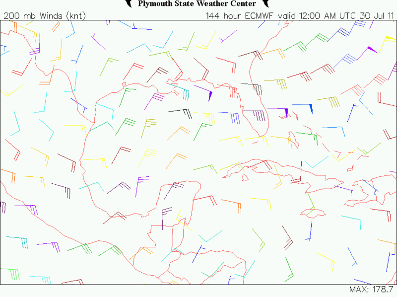
Looking at the euro from last night, it shows that it may have a brief period of better upper level conditions for development when it reaches the SE GOM, Tuesday night or Wednesday morning, as the tropical wave moves WNW or NW across the GOM so will a pocket of better UL conditions move westward along with it before UL conditions go down hill again in the GOM by Friday.
Wednesday, if the tropical wave is in the SE GOM it will have light winds aloft :
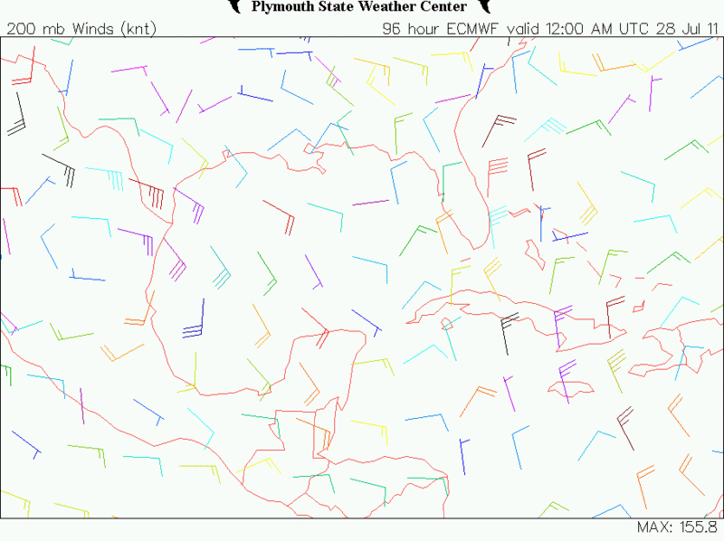
Thursday, if the tropical wave is in the central GOM it will also have light winds aloft:
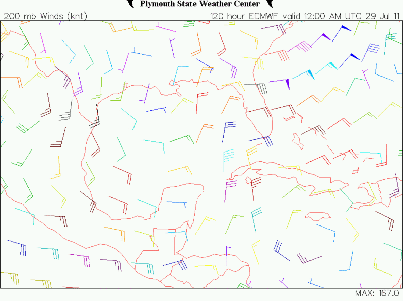
Friday, strong easterly shear in the central & eastern GOM take up:
0 likes
-
wxman57

- Moderator-Pro Met

- Posts: 23171
- Age: 68
- Joined: Sat Jun 21, 2003 8:06 pm
- Location: Houston, TX (southwest)
Re: ATL: INVEST 90L - Discussion
Not NE shear, increased low-level flow I mentioned yesterday. Lower level winds now 25-35 kts south of the DR. That's disrupting convection. Have to wait for it to slow down by the Yucatan.
0 likes
Who is online
Users browsing this forum: No registered users and 28 guests