90L status update:
As of the time of this post (8:50 AM EDT) 90L is still active and has not been deactivated,despite no tropical model runs for almost 48 hours.
ATL: DON - Remnant - Discussion
Moderator: S2k Moderators
-
cycloneye

- Admin

- Posts: 149245
- Age: 69
- Joined: Thu Oct 10, 2002 10:54 am
- Location: San Juan, Puerto Rico
Re: ATL: INVEST 90L - Discussion
0 likes
Visit the Caribbean-Central America Weather Thread where you can find at first post web cams,radars
and observations from Caribbean basin members Click Here
and observations from Caribbean basin members Click Here
-
Aric Dunn
- Category 5

- Posts: 21238
- Age: 43
- Joined: Sun Sep 19, 2004 9:58 pm
- Location: Ready for the Chase.
- Contact:
Re: ATL: INVEST 90L - Discussion
cycloneye wrote:90L status update:
As of the time of this post (8:50 AM EDT) 90L is still active and has not been deactivated,despite no tropical model runs for almost 48 hours.
not surprised. the potential still exists but the last couple days the land interaction pretty much made it impossible but now that its slowing down and in the western carrib it should slowly get a better chance to develop.
0 likes
Note: If I make a post that is brief. Please refer back to previous posts for the analysis or reasoning. I do not re-write/qoute what my initial post said each time.
If there is nothing before... then just ask
Space & Atmospheric Physicist, Embry-Riddle Aeronautical University,
I believe the sky is falling...
If there is nothing before... then just ask
Space & Atmospheric Physicist, Embry-Riddle Aeronautical University,
I believe the sky is falling...

Re: ATL: INVEST 90L - Discussion
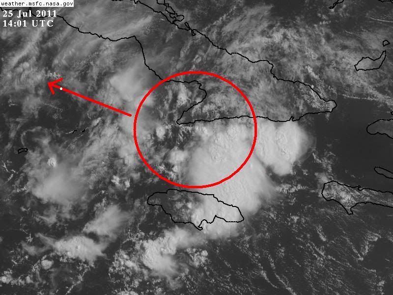
Appears to be a CC spin just off the southeast coast of Cuba just west of Santiago De Cuba. It's probably at the 700 mb level as thats where the strongest vorticity is now. Appears that this will stay south of Cuba where environmental conditions are not that hostile. Still needs to be watched. The wave will slow as mid-level ridging weakens and a trough develops over the SE US the next few days.
http://www.aviationweather.gov/adds/satellite/displaySat.php?region=CARIB&isingle=multiple&itype=vis
Note: Lowest land based pressure now at Montego Bay JAM at 1013 mb. Pressures while still high have dropped 1-2 mb over the last 24 hrs.
http://www.aviationweather.gov/adds/satellite/displaySat.php?region=CARIB&isingle=multiple&itype=vis
Note: Lowest land based pressure now at Montego Bay JAM at 1013 mb. Pressures while still high have dropped 1-2 mb over the last 24 hrs.
Last edited by ronjon on Mon Jul 25, 2011 8:11 am, edited 1 time in total.
0 likes

Re: ATL: INVEST 90L - Discussion
Not a bad little flare along the wave axis between Jamaica and Cuba with overshooting top and expanding cirrus outflow.
Obs on north shore of Jamaica and SE shore of Cuba are showing winds basically out of the north.
Buoys in west Carib are tending some what lower at about 1013mb.
Will be interesting to see what happens once the wave clears Jamaica.
Obs on north shore of Jamaica and SE shore of Cuba are showing winds basically out of the north.
Buoys in west Carib are tending some what lower at about 1013mb.
Will be interesting to see what happens once the wave clears Jamaica.
0 likes

Re: Re:
TwisterFanatic wrote:ROCK wrote:NDG wrote:If tonight's NAM verifies it will be the first this year it develops a storm with no global model support, I lost count of how many ghost storms it has try to develop this year, lol.
show me the global who sniffed out Bret.....wasnt the jacked up GFS thats for sure....
or Cindy for that matter.
That's because they were both formed out of a frontal boundary with a very small scale at the surface which models have a tough time on picking up, and that was noticed even after Bret formed. But they did forecast the formation of their H85 vorticity a few days before they both formed.
Global models do better with larger scale disturbances like 90L is.
A good example of how well they did in forecasting no development was with 94L
0 likes
-
Stormcenter
- S2K Supporter

- Posts: 6689
- Joined: Wed Sep 03, 2003 11:27 am
- Location: Houston, TX
Re: ATL: INVEST 90L - Discussion
This definitely still has potential in my opinion.
As others have posted you can clearly see some rotation south
of eastern Cuba.
http://www.ssd.noaa.gov/goes/east/carb/flash-vis.html
As others have posted you can clearly see some rotation south
of eastern Cuba.
http://www.ssd.noaa.gov/goes/east/carb/flash-vis.html
0 likes

Re: ATL: INVEST 90L - Discussion
GCANE wrote:Not a bad little flare along the wave axis between Jamaica and Cuba with overshooting top and expanding cirrus outflow.
Obs on north shore of Jamaica and SE shore of Cuba are showing winds basically out of the north.
Buoys in west Carib are tending some what lower at about 1013mb.
Will be interesting to see what happens once the wave clears Jamaica.
agree...that flare up looks like a surface low is setting up.....notice the lower clouds inflow into that convection....
0 likes
If the vorticity can stay away from Cuba, who knows they may start tropical model runs on it again at 18z, IMO.
If the vorticity is the same that has been present in the past 48 hrs, based on positioning it has now slowed down in 15-20 mph range during the past 24 hrs when the previous 24 hrs I estimate it that it was in the 20-25 mph.
They should had kept chances at least 10% while the system is in the Caribbean, hostile UL winds are far away on the GOM.
0 likes
-
OuterBanker
- S2K Supporter
- Posts: 1761
- Joined: Wed Feb 26, 2003 10:53 am
- Location: Nags Head, NC
- Contact:
Re: ATL: INVEST 90L - Discussion
All obs on the east end of Jamaica now have winds turning to the NNW.
Convection is responding very well to the surface convergence.
IMHO, NHC may have been looking a little too far west on the 8AM.
Convection is responding very well to the surface convergence.
IMHO, NHC may have been looking a little too far west on the 8AM.
0 likes
-
SouthDadeFish

- Professional-Met

- Posts: 2835
- Joined: Thu Sep 23, 2010 2:54 pm
- Location: Miami, FL
- Contact:
Re: ATL: INVEST 90L - Discussion
GCANE wrote:All obs on the east end of Jamaica now have winds turning to the NNW.
Convection is responding very well to the surface convergence.
IMHO, NHC may have been looking a little too far west on the 8AM.
Completely agree. I'm looking at radar from Pilon and while I don't see anything too impressive, it appears that there is some broad cyclonic turning now evident on radar. It is relatively weak on the west side but definitely better than it used to be.
0 likes
-
cycloneye
- Admin
- Posts: 149245
- Age: 69
- Joined: Thu Oct 10, 2002 10:54 am
- Location: San Juan, Puerto Rico
Re: ATL: INVEST 90L - Discussion
SouthDadeFish wrote:GCANE wrote:All obs on the east end of Jamaica now have winds turning to the NNW.
Convection is responding very well to the surface convergence.
IMHO, NHC may have been looking a little too far west on the 8AM.
Completely agree. I'm looking at radar from Pilon and while I don't see anything too impressive, it appears that there is some broad cyclonic turning now evident on radar. It is relatively weak on the west side but definitely better than it used to be.
0 likes
Visit the Caribbean-Central America Weather Thread where you can find at first post web cams,radars
and observations from Caribbean basin members Click Here
and observations from Caribbean basin members Click Here
-
cycloneye
- Admin
- Posts: 149245
- Age: 69
- Joined: Thu Oct 10, 2002 10:54 am
- Location: San Juan, Puerto Rico
Re: ATL: INVEST 90L - Discussion
WEATHER RECONNAISSANCE FLIGHTS
CARCAH, NATIONAL HURRICANE CENTER, MIAMI, FL.
0935 AM EDT MON 25 JULY 2011
SUBJECT: TROPICAL CYCLONE PLAN OF THE DAY (TCPOD)
VALID 26/1100Z TO 27/1100Z JULY 2011
TCPOD NUMBER.....11-055
I. ATLANTIC REQUIREMENTS
1. NEGATIVE RECONNAISSANCE REQUIREMENTS.
2. OUTLOOK FOR SUCCEEDING DAY.....NEGATIVE.
CARCAH, NATIONAL HURRICANE CENTER, MIAMI, FL.
0935 AM EDT MON 25 JULY 2011
SUBJECT: TROPICAL CYCLONE PLAN OF THE DAY (TCPOD)
VALID 26/1100Z TO 27/1100Z JULY 2011
TCPOD NUMBER.....11-055
I. ATLANTIC REQUIREMENTS
1. NEGATIVE RECONNAISSANCE REQUIREMENTS.
2. OUTLOOK FOR SUCCEEDING DAY.....NEGATIVE.
0 likes
Visit the Caribbean-Central America Weather Thread where you can find at first post web cams,radars
and observations from Caribbean basin members Click Here
and observations from Caribbean basin members Click Here
-
cycloneye
- Admin
- Posts: 149245
- Age: 69
- Joined: Thu Oct 10, 2002 10:54 am
- Location: San Juan, Puerto Rico
Re: ATL: INVEST 90L - Discussion
At 10:15 AM EDT ATCF deactivated 90L
ftp://ftp.tpc.ncep.noaa.gov/atcf/tcweb/ ... 902011.ren
NHC_ATCF
invest_DEACTIVATE_al902011.ren
FSTDA
R
U
040
010
0000
201107251415
NONE
NOTIFY=ATRP
END
[/size]
ftp://ftp.tpc.ncep.noaa.gov/atcf/tcweb/ ... 902011.ren
NHC_ATCF
invest_DEACTIVATE_al902011.ren
FSTDA
R
U
040
010
0000
201107251415
NONE
NOTIFY=ATRP
END
[/size]
0 likes
Visit the Caribbean-Central America Weather Thread where you can find at first post web cams,radars
and observations from Caribbean basin members Click Here
and observations from Caribbean basin members Click Here
-
chrisnnavarre
- Category 1

- Posts: 309
- Joined: Fri Oct 03, 2003 5:52 pm
- Contact:
Re: ATL: INVEST 90L - Discussion
Anyone ready to declare cyclogenesis for Don... it's really the first significant wave to pass south of Cuba from the Atlantic this year isn't it.
I have a feeling that this is going to be a long season....

I have a feeling that this is going to be a long season....
0 likes
-
chrisnnavarre
- Category 1
- Posts: 309
- Joined: Fri Oct 03, 2003 5:52 pm
- Contact:
Re: ATL: INVEST 90L - Discussion
chrisnnavarre wrote:Anyone ready to declare cyclogenesis for Don... it's really the first significant wave to pass south of Cuba from the Atlantic this year isn't it.
I have a feeling that this is going to be a long season....
Obviously the NHC is not....especially since they just deactivated the Invest, and just when it started turning. So when they reactivate it will it still be 90L or a new 91L invest?
Last edited by chrisnnavarre on Mon Jul 25, 2011 9:34 am, edited 2 times in total.
0 likes
-
SouthDadeFish
- Professional-Met
- Posts: 2835
- Joined: Thu Sep 23, 2010 2:54 pm
- Location: Miami, FL
- Contact:
I'm wondering if Jamaica is acting to slow down some of the fast easterly flow to the south of the "center" of 90L through friction due to land. As a result this would naturally create a vorticity effect with the northern half (between Cuba and Jamaica) moving quicker than the southern half.
Also why deactivate the invest at its most promising time in its life? I guess they really gave up on this thing. Not sure if I blame them.
Also why deactivate the invest at its most promising time in its life? I guess they really gave up on this thing. Not sure if I blame them.
0 likes
-
cycloneye
- Admin
- Posts: 149245
- Age: 69
- Joined: Thu Oct 10, 2002 10:54 am
- Location: San Juan, Puerto Rico
Re:
SouthDadeFish wrote:I'm wondering if Jamaica is acting to slow down some of the fast easterly flow to the south of the "center" of 90L through friction due to land. As a result this would naturally create a vorticity effect with the northern half (between Cuba and Jamaica) moving quicker than the southern half.
Also why deactivate the invest at its most promising time in its life? I guess they really gave up on this thing. Not sure if I blame them.
In the past,some invests that have been deactivated,have been again activated,so dont discount the return of 90L as invest once again.
0 likes
Visit the Caribbean-Central America Weather Thread where you can find at first post web cams,radars
and observations from Caribbean basin members Click Here
and observations from Caribbean basin members Click Here

Well it probably wouldn't get invested in its current state so not too shocking its been decativated.
I also wouldn't be too shocked to see 90L come back again as well at some point in the near future.
I also wouldn't be too shocked to see 90L come back again as well at some point in the near future.
0 likes
Personal Forecast Disclaimer:
The posts in this forum are NOT official forecast and should not be used as such. They are just the opinion of the poster and may or may not be backed by sound meteorological data. They are NOT endorsed by any professional institution or storm2k.org. For official information, please refer to the NHC and NWS products
The posts in this forum are NOT official forecast and should not be used as such. They are just the opinion of the poster and may or may not be backed by sound meteorological data. They are NOT endorsed by any professional institution or storm2k.org. For official information, please refer to the NHC and NWS products
Who is online
Users browsing this forum: No registered users and 15 guests