

ATL: DON - Remnant - Discussion
Moderator: S2k Moderators


Re: ATL: DON - Tropical Storm - Discussion
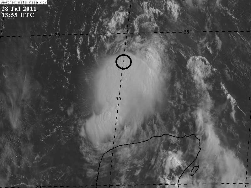
@Ptracker, IMO, I think the center is under the NW part of the CDO, it is wrapping around convection, and appears to be forming feederbands to its NW as well....just my opinion, not official. 

0 likes


-
Dave

- Retired Staff

- Posts: 13442
- Age: 75
- Joined: Tue Aug 01, 2006 3:57 pm
- Location: Milan Indiana
- Contact:
358
URNT15 KNHC 281407
AF303 0204A DON HDOB 25 20110728
135800 2341N 08936W 8435 01557 0098 +167 +026 204025 026 040 004 00
135830 2340N 08934W 8426 01565 0095 +172 +025 200024 026 040 002 00
135900 2339N 08933W 8433 01561 0098 +170 +026 202024 025 039 002 00
135930 2338N 08932W 8431 01562 0098 +170 +030 206024 025 042 005 00
140000 2337N 08931W 8429 01566 0104 +164 +033 208026 027 042 005 00
140030 2336N 08930W 8434 01563 0104 +166 +034 201029 029 042 005 00
140100 2335N 08928W 8429 01572 0105 +169 +034 202025 026 043 004 00
140130 2334N 08927W 8430 01571 0109 +164 +036 199025 025 042 005 00
140200 2333N 08926W 8428 01574 0109 +166 +037 202024 024 041 003 00
140230 2332N 08925W 8430 01572 0110 +167 +038 197024 025 040 005 00
140300 2331N 08924W 8430 01573 0108 +170 +039 194025 026 039 006 00
140330 2329N 08923W 8429 01574 0107 +173 +041 185021 022 039 005 00
140400 2328N 08921W 8428 01574 0106 +174 +043 191021 023 040 006 00
140430 2327N 08920W 8431 01573 0109 +170 +045 191023 024 040 006 00
140500 2326N 08919W 8430 01574 0110 +170 +046 197026 026 038 005 00
140530 2325N 08918W 8433 01573 0113 +167 +047 202027 028 040 005 00
140600 2324N 08917W 8430 01578 0117 +163 +047 200028 028 038 006 00
140630 2323N 08916W 8430 01578 0119 +162 +046 193027 028 035 007 00
140700 2322N 08915W 8429 01578 0116 +166 +044 189026 026 035 005 00
140730 2321N 08913W 8432 01577 0113 +170 +043 186025 025 034 003 00
$$
;
0 likes
-
ozonepete
- Professional-Met

- Posts: 4743
- Joined: Mon Sep 07, 2009 3:23 pm
- Location: From Ozone Park, NYC / Now in Brooklyn, NY
Re: ATL: DON - Tropical Storm - Discussion
Don is not behaving himself as far as the diurnal convection blow-ups go, is he? Of course that pattern doesn't always hold, and Don is a good example so far. It had nice convective bursts yesterday during the day, then nothing much at all last night during the expected nocturnal max. Now it's getting some pretty impressive blow-ups again as we go into full daylight. Of course that rule holds true better for stronger systems, for one thing.
0 likes

Re:
JGrin87 wrote:is there a website that gives updates on the visible imagery quicker than the noaa site? it generally takes 45 minutes to update, which is very slow
http://weather.msfc.nasa.gov/GOES/goeseastconus.html
Click on any part of the image to zoom in.
0 likes
-
Dave
- Retired Staff
- Posts: 13442
- Age: 75
- Joined: Tue Aug 01, 2006 3:57 pm
- Location: Milan Indiana
- Contact:
043
URNT15 KNHC 281417
AF303 0204A DON HDOB 26 20110728
140800 2320N 08912W 8429 01582 0117 +169 +043 188026 028 033 003 00
140830 2319N 08911W 8432 01577 0121 +161 +045 197029 030 033 001 00
140900 2318N 08910W 8430 01583 0125 +160 +046 196030 030 032 002 00
140930 2317N 08909W 8429 01583 0122 +164 +047 192029 030 031 001 00
141000 2316N 08908W 8436 01578 0124 +162 +048 186030 030 029 002 00
141030 2314N 08907W 8432 01582 0122 +165 +049 190030 030 028 001 03
141100 2313N 08906W 8433 01580 0121 +168 +051 191030 030 027 001 00
141130 2312N 08905W 8429 01585 0120 +170 +052 192030 031 030 001 03
141200 2311N 08905W 8433 01583 0121 +168 +054 192033 034 030 000 00
141230 2309N 08905W 8429 01585 0123 +165 +055 192036 036 029 002 00
141300 2308N 08904W 8432 01583 0125 +163 +056 190033 035 029 002 03
141330 2307N 08903W 8433 01584 0126 +165 +056 189031 033 030 003 00
141400 2306N 08902W 8423 01599 0126 +166 +057 193035 036 034 004 00
141430 2306N 08900W 8432 01583 0124 +165 +056 193033 034 046 004 00
141500 2305N 08859W 8431 01584 0123 +166 +055 197033 033 045 005 00
141530 2304N 08857W 8420 01602 0130 +160 +054 184032 038 044 011 00
141600 2303N 08856W 8443 01574 0135 +151 +050 185035 036 042 015 03
141630 2302N 08855W 8424 01591 0130 +160 +045 185035 037 036 003 00
141700 2302N 08853W 8416 01601 0127 +165 +041 181032 032 034 002 00
141730 2301N 08852W 8407 01611 0127 +167 +040 187032 032 035 001 00
$$
;
0 likes

-
cycloneye

- Admin

- Posts: 149097
- Age: 69
- Joined: Thu Oct 10, 2002 10:54 am
- Location: San Juan, Puerto Rico
Re: ATL: DON - Recon Discussion
I have not seen a VDM on this recent pass.Is because they missed the center?
0 likes
Visit the Caribbean-Central America Weather Thread where you can find at first post web cams,radars
and observations from Caribbean basin members Click Here
and observations from Caribbean basin members Click Here
-
x-y-no

- Category 5

- Posts: 8359
- Age: 65
- Joined: Wed Aug 11, 2004 12:14 pm
- Location: Fort Lauderdale, FL
Re:
JGrin87 wrote:is there a website that gives updates on the visible imagery quicker than the noaa site? it generally takes 45 minutes to update, which is very slow
RAMSDIS is a bit quicker: http://rammb.cira.colostate.edu/ramsdis ... opical.asp
and if you don't mind the uncorrected perspective, there's GHCC: http://www.ghcc.msfc.nasa.gov/GOES/
0 likes

-
Dave
- Retired Staff
- Posts: 13442
- Age: 75
- Joined: Tue Aug 01, 2006 3:57 pm
- Location: Milan Indiana
- Contact:
000
URNT12 KNHC 281422 CCA
VORTEX DATA MESSAGE AL042011
A. 28/13:50:10Z
B. 23 deg 59 min N
089 deg 55 min W
C. 850 mb 1442 m
D. 29 kt
E. 201 deg 2 nm
F. 081 deg 32 kt
G. 346 deg 2 nm
H. EXTRAP 1001 mb
I. 18 C / 1523 m
J. 26 C / 1515 m
K. 8 C / NA
L. NA
M. NA
N. 12345 / 08
O. 0.02 / 1.5 nm
P. AF303 0204A DON OB 07 CCA
MAX FL WIND 52 KT E QUAD 11:57:10Z
MAX OUTBOUND FL WIND 38 KT SE QUAD 14:15:50Z
SLP EXTRAP FROM 850 MB
EYE SONDE MEASURED 1004MB WITH 17 KTS SFC WIND
FEEDERBAND CROSSING SE OUTBOUND LEG 70 NM SE OF CTR
COR FOR MAX OUTBOUND FL WIND IN CONVECTIVE BAND
;
0 likes

-
Dave
- Retired Staff
- Posts: 13442
- Age: 75
- Joined: Tue Aug 01, 2006 3:57 pm
- Location: Milan Indiana
- Contact:
000
UZNT13 KNHC 281425
XXAA 78148 99240 70899 08149 99004 27405 23517 00034 27005 24015
92724 23804 28507 85464 22231 34005 88999 77999
31313 09608 81350
61616 AF303 0204A DON OB 08
62626 EYE SPL 2399N08991W 1351 MBL WND 24012 AEV 20802 DLM WND 26
508 003845 WL150 23514 083 REL 2399N08991W 135001 SPG 2398N08990W
135152 =
XXBB 78148 99240 70899 08149 00004 27405 11872 21412 22850 22231
33846 23057 44845 23464
21212 00004 23517 11989 23014 22944 27505 33923 28007 44912 32001
55896 29509 66874 27513 77865 27508 88858 27009 99845 02008
31313 09608 81350
61616 AF303 0204A DON OB 08
62626 EYE SPL 2399N08991W 1351 MBL WND 24012 AEV 20802 DLM WND 26
508 003845 WL150 23514 083 REL 2399N08991W 135001 SPG 2398N08990W
135152 =
;
0 likes
Who is online
Users browsing this forum: No registered users and 48 guests