ATL: EMILY - Remnants
Moderator: S2k Moderators


Ok still swirling on the east.
http://www.ssd.noaa.gov/goes/flt/t2/flash-vis.html
http://www.ssd.noaa.gov/goes/flt/t2/flash-vis.html
0 likes
_____________________
There can be only one Hypercane.....

There can be only one Hypercane.....
-
gatorcane

- S2K Supporter

- Posts: 23708
- Age: 48
- Joined: Sun Mar 13, 2005 3:54 pm
- Location: Boca Raton, FL
The 18Z NAM clearly shows the well-advertised weakness at 66 hours from now. You can see the big break in the ridge between Florida and about 60W or just north of Puerto Rico and the cold front/trough on the top of the image with all of the barbs pointing ENE....a strong system should slide nicely into that break like the GFDL, ECMWF, and CMC are showing:

Last edited by gatorcane on Sun Jul 31, 2011 3:40 pm, edited 1 time in total.
0 likes

Re: ATL: INVEST 91L - Discussion
I don't think they will find a TD anywhere out this time around. to much low level flow.
0 likes
The following post is NOT an official forecast and should not be used as such. It is just the opinion of the poster and may or may not be backed by sound meteorological data. It is NOT endorsed by any professional institution including storm2k.org For Official Information please refer to the NHC and NWS products.
-
northtxboy

- Category 1

- Posts: 262
- Age: 44
- Joined: Mon Jan 03, 2011 1:50 pm
- Location: Windom Tx
- Contact:
I have been reading and watching what you all say for awhile now. I dont really post to much cause 90% of the time I have no idea what you all are talking about and by the time I do my own research to find out its all changed and we are talking about something elese. I do alot of reading and alot of model watching just like all of you and most nights I am up till 2am just like most of you. I would like to share my thoughts with u all about 91L (emily). These are just my thoughts and I am not a pro met or do I have any kind of back ground like that. This is just my thoughts and I would like to know what everyone thinks of them. everyone keeps talking about this trough that will build off the east coast that will cause 91L to recurve to the east and miss the U.S east coast. For a time I was with u all on that. But now I am kinda stuck in the middle. The trough dips down pretty low down past florida and is very amplified at the begining but notice that the short wave to the north is lifting out before 91L can be affected meaning that the base of the trough is leaving,the jet is leaving meaning the piece of the trough that sags down past florida MIGHT NOT make the ride and is then left behind. Its a trough split and that would start moving to the west over florida and into the GOM. There is a real possabilty that 91L (emily) might try to follow this upper level low as the ridge builds to the north. I think and these are just my thoughts, I think florida has a big bullseye on it and should be closely watched over the next few days. I am not saying it will get hit but it sure looks close to me. 
0 likes
-
stormchazer

- Category 5

- Posts: 2462
- Joined: Fri Aug 29, 2003 12:00 pm
- Location: Lakeland, Florida
- Contact:
Re:
Bobo2000 wrote:Ok still swirling on the east.
http://www.ssd.noaa.gov/goes/flt/t2/flash-vis.html
Great look there. If you try to focus on lower level flows it does appear there are twin Lows but at what levels, who knows with out recon and no good surface observations. It will be interesting to see how the models hash out once, oh and if this develops. This is definitely a good "late-early season" development to watch.
0 likes
The posts or stuff said are NOT an official forecast and my opinion alone. Please look to the NHC and NWS for official forecasts and products.
Model Runs Cheat Sheet:
GFS (5:30 AM/PM, 11:30 AM/PM)
HWRF, GFDL, UKMET, NAVGEM (6:30-8:00 AM/PM, 12:30-2:00 AM/PM)
ECMWF (1:45 AM/PM)
TCVN is a weighted averaged
Opinions my own.
Model Runs Cheat Sheet:
GFS (5:30 AM/PM, 11:30 AM/PM)
HWRF, GFDL, UKMET, NAVGEM (6:30-8:00 AM/PM, 12:30-2:00 AM/PM)
ECMWF (1:45 AM/PM)
TCVN is a weighted averaged
Opinions my own.
-
Aric Dunn
- Category 5
- Posts: 21238
- Age: 43
- Joined: Sun Sep 19, 2004 9:58 pm
- Location: Ready for the Chase.
- Contact:
Re: Re:
stormchazer wrote:Bobo2000 wrote:Ok still swirling on the east.
http://www.ssd.noaa.gov/goes/flt/t2/flash-vis.html
Great look there. If you try to focus on lower level flows it does appear there are twin Lows but at what levels, who knows with out recon and no good surface observations. It will be interesting to see how the models hash out once, oh and if this develops. This is definitely a good "late-early season" development to watch.
everyone should really be using RGB. the layers are different colors... highlighted so that its easier to discern what level the clouds are at. ITs just a better tool all around
http://www.ssd.noaa.gov/goes/flt/t2/loop-rgb.html
0 likes
Note: If I make a post that is brief. Please refer back to previous posts for the analysis or reasoning. I do not re-write/qoute what my initial post said each time.
If there is nothing before... then just ask
Space & Atmospheric Physicist, Embry-Riddle Aeronautical University,
I believe the sky is falling...
If there is nothing before... then just ask
Space & Atmospheric Physicist, Embry-Riddle Aeronautical University,
I believe the sky is falling...
-
'CaneFreak

- Category 5
- Posts: 1487
- Joined: Mon Jun 05, 2006 10:50 am
- Location: New Bern, NC
Re:
I strongly agree here...thanks for sharing your opinion...it also looks to me that the trough split will be short lived and the ridge will build back in...in addition, I think the delayed strengthening of the parent disturbance would also argue for a further west track. This will definitely need to be watched in the coming days.
northtxboy wrote:I have been reading and watching what you all say for awhile now. I dont really post to much cause 90% of the time I have no idea what you all are talking about and by the time I do my own research to find out its all changed and we are talking about something elese. I do alot of reading and alot of model watching just like all of you and most nights I am up till 2am just like most of you. I would like to share my thoughts with u all about 91L (emily). These are just my thoughts and I am not a pro met or do I have any kind of back ground like that. This is just my thoughts and I would like to know what everyone thinks of them. everyone keeps talking about this trough that will build off the east coast that will cause 91L to recurve to the east and miss the U.S east coast. For a time I was with u all on that. But now I am kinda stuck in the middle. The trough dips down pretty low down past florida and is very amplified at the begining but notice that the short wave to the north is lifting out before 91L can be affected meaning that the base of the trough is leaving,the jet is leaving meaning the piece of the trough that sags down past florida MIGHT NOT make the ride and is then left behind. Its a trough split and that would start moving to the west over florida and into the GOM. There is a real possabilty that 91L (emily) might try to follow this upper level low as the ridge builds to the north. I think and these are just my thoughts, I think florida has a big bullseye on it and should be closely watched over the next few days. I am not saying it will get hit but it sure looks close to me.
0 likes
-
Aric Dunn
- Category 5
- Posts: 21238
- Age: 43
- Joined: Sun Sep 19, 2004 9:58 pm
- Location: Ready for the Chase.
- Contact:
and switches to infrared at night...
0 likes
Note: If I make a post that is brief. Please refer back to previous posts for the analysis or reasoning. I do not re-write/qoute what my initial post said each time.
If there is nothing before... then just ask
Space & Atmospheric Physicist, Embry-Riddle Aeronautical University,
I believe the sky is falling...
If there is nothing before... then just ask
Space & Atmospheric Physicist, Embry-Riddle Aeronautical University,
I believe the sky is falling...
-
Rgv20

- S2K Supporter
- Posts: 2466
- Age: 39
- Joined: Wed Jan 05, 2011 5:42 pm
- Location: Edinburg/McAllen Tx
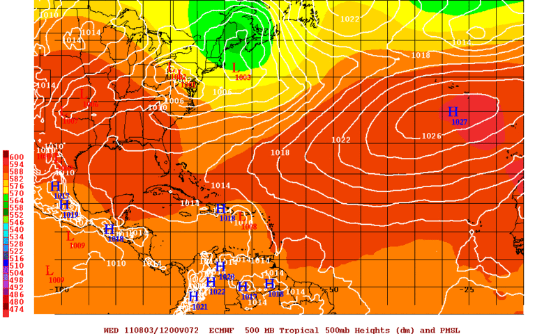
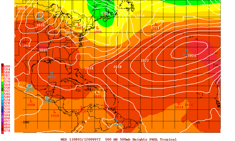
Re: ATL: INVEST 91L - Models
This is the forecast for 72hrs (Wednesday Morning) from the 12z runs GFS, ECMWF, and UKMET. Notice that the UKMET is weaker with the trough than both the GFS and Euro and thus is further west and faster than the other two models.


0 likes
The following post is NOT an official forecast and should not be used as such. It is just the opinion of the poster and may or may not be backed by sound meteorological data. It is NOT endorsed by any professional institution including storm2k.org For Official Information please refer to the NHC and NWS products.
-
TwisterFanatic

- Category 5
- Posts: 1041
- Joined: Mon Jun 28, 2010 12:43 pm
- Location: Sallisaw, Oklahoma
First time looking at this today, I see two blobs, which one is looking the best to become the dominate one? West?
0 likes
Personal Forecast Disclaimer:
The posts in this forum are NOT official forecast and should not be used as such. They are just the opinion of the poster and may or may not be backed by sound meteorological data. They are NOT endorsed by any professional institution or storm2k.org. For official information, please refer to the NHC and NWS products.
The posts in this forum are NOT official forecast and should not be used as such. They are just the opinion of the poster and may or may not be backed by sound meteorological data. They are NOT endorsed by any professional institution or storm2k.org. For official information, please refer to the NHC and NWS products.
-
ozonepete
- Professional-Met

- Posts: 4743
- Joined: Mon Sep 07, 2009 3:23 pm
- Location: From Ozone Park, NYC / Now in Brooklyn, NY
Re: ATL: INVEST 91L - Discussion
Totally right, Aric. I use it most of the time, and it's especially useful for situations like this.
0 likes

gatorcane, yeah that weakness is very obvious as you say, it'll probably at least begin a WNW motion.
I still think it maybe a close call, I'm thinking some of the models are overdoing the weakness, to get that sort of weakness in very early august would be slightly unusual, though not unheard of.
As per normal, strength/position going to be key.
UKMO has a left bias FWIW, usually overdoes the ridging a little, in the same way as GFS overdoes troughing.
0 likes
Personal Forecast Disclaimer:
The posts in this forum are NOT official forecast and should not be used as such. They are just the opinion of the poster and may or may not be backed by sound meteorological data. They are NOT endorsed by any professional institution or storm2k.org. For official information, please refer to the NHC and NWS products
The posts in this forum are NOT official forecast and should not be used as such. They are just the opinion of the poster and may or may not be backed by sound meteorological data. They are NOT endorsed by any professional institution or storm2k.org. For official information, please refer to the NHC and NWS products
-
Aric Dunn
- Category 5
- Posts: 21238
- Age: 43
- Joined: Sun Sep 19, 2004 9:58 pm
- Location: Ready for the Chase.
- Contact:
Re:
KWT wrote:gatorcane, yeah that weakness is very obvious as you say, it'll probably at least begin a WNW motion.
I still think it maybe a close call, I'm thinking some of the models are overdoing the weakness, to get that sort of weakness in very early august would be slightly unusual, though not unheard of.
As per normal, strength/position going to be key.
UKMO has a left bias FWIW, usually overdoes the ridging a little, in the same way as GFS overdoes troughing.
but its not responding the weakness very much.. could be to far south .. and weak
0 likes
Note: If I make a post that is brief. Please refer back to previous posts for the analysis or reasoning. I do not re-write/qoute what my initial post said each time.
If there is nothing before... then just ask
Space & Atmospheric Physicist, Embry-Riddle Aeronautical University,
I believe the sky is falling...
If there is nothing before... then just ask
Space & Atmospheric Physicist, Embry-Riddle Aeronautical University,
I believe the sky is falling...
-
Aric Dunn
- Category 5
- Posts: 21238
- Age: 43
- Joined: Sun Sep 19, 2004 9:58 pm
- Location: Ready for the Chase.
- Contact:
And if you look at the 72 hour nam the ridge starts building back west and the gap is closing as the trough lifts out
0 likes
Note: If I make a post that is brief. Please refer back to previous posts for the analysis or reasoning. I do not re-write/qoute what my initial post said each time.
If there is nothing before... then just ask
Space & Atmospheric Physicist, Embry-Riddle Aeronautical University,
I believe the sky is falling...
If there is nothing before... then just ask
Space & Atmospheric Physicist, Embry-Riddle Aeronautical University,
I believe the sky is falling...

Re: ATL: INVEST 91L - Discussion
this thing is caught up in the low level flow....the east looks like the one to develope....but that dang west blob dosent look to shabby either....what a weird set up.....look at the low level convergence...
http://tropic.ssec.wisc.edu/real-time/w ... oom=&time=
Emily in 05 did the same thing almost....kept going west with the low level...
http://tropic.ssec.wisc.edu/real-time/w ... oom=&time=
Emily in 05 did the same thing almost....kept going west with the low level...
0 likes
-
gatorcane
- S2K Supporter
- Posts: 23708
- Age: 48
- Joined: Sun Mar 13, 2005 3:54 pm
- Location: Boca Raton, FL
Re:
Aric Dunn wrote:And if you look at the 72 hour nam the ridge starts building back west and the gap is closing as the trough lifts out
I do see that. Here is the 84 hour 18Z NAM. In fact the 12Z NAM was not showing the ridging build back like that:

0 likes
-
vbhoutex
- Storm2k Executive

- Posts: 29148
- Age: 74
- Joined: Wed Oct 09, 2002 11:31 pm
- Location: Cypress, TX
- Contact:
Re: ATL: INVEST 91L - Discussion
Am I seeing the MLC from the East portion starting to move over the now very obvious LLC on the SE side of the West system? I'm afraid to say what I am seeing as it seems to change from hour to hour if not minute to minute. 
0 likes
Skywarn, C.E.R.T.
Please click below to donate to STORM2K to help with the expenses of keeping the site going:

Please click below to donate to STORM2K to help with the expenses of keeping the site going:
Re:
gatorcane wrote:I am looking at the floater and superimposed the LAT/LON grid. Certainly seems like the BLOBS are heading nearly due W, maybe just a hair north of due W...
Looks to me to be somewhere between 275-280 degrees, not exactly gaining all that much latitude, think thats coming in 24-36hrs time when it gets into the Caribbean.
0 likes
Personal Forecast Disclaimer:
The posts in this forum are NOT official forecast and should not be used as such. They are just the opinion of the poster and may or may not be backed by sound meteorological data. They are NOT endorsed by any professional institution or storm2k.org. For official information, please refer to the NHC and NWS products
The posts in this forum are NOT official forecast and should not be used as such. They are just the opinion of the poster and may or may not be backed by sound meteorological data. They are NOT endorsed by any professional institution or storm2k.org. For official information, please refer to the NHC and NWS products
-
hurricanefloyd5
- Category 5
- Posts: 1659
- Age: 45
- Joined: Sun May 02, 2004 10:53 am
- Location: Spartanburg
- Contact:
Re:
Aric Dunn wrote:And if you look at the 72 hour nam the ridge starts building back west and the gap is closing as the trough lifts out
so what dose this mean aric?
0 likes
Who is online
Users browsing this forum: No registered users and 42 guests