ATL: EMILY - Remnants

Moderator: S2k Moderators

Message
Author
User avatar
northjaxpro
S2K Supporter
S2K Supporter
Posts: 8900
Joined: Mon Sep 27, 2010 11:21 am
Location: Jacksonville, FL

Re:

#6121 Postby northjaxpro » Wed Aug 03, 2011 1:44 pm

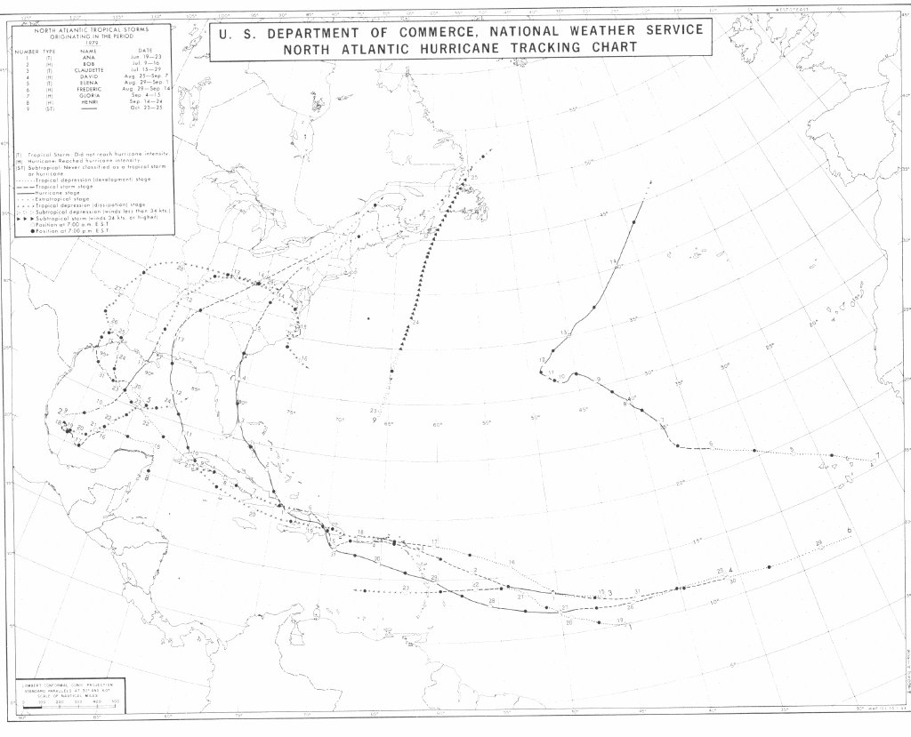
Weatherboy1 wrote:Again, the best thing Emily has going for her is the fact she won't be doing battle with the mountains of the DR/Haiti. That's a big difference from what we all expected 24-36 hours ago. Wonder if she's not due for a "1979 David" type track after she clears the island. Looks pretty close.

http://www.nhc.noaa.gov/tracks/1979atl.gif


Since Emily was designated a TS and looking at how over time this may evolve, I too have also mentioned that this may be a set-up similar to David in '79. The difference here is that Emily will likely miss having direct interaction with Hispaniola, opposed to David when he went directly over the rugged terrain of the island.

Another poster mentioned Cleo in '60, which traveled over Eastern Cuba and later effected South FL and up the East Coast. This may be a similar set-up like that one as well. Time will tell.
Last edited by northjaxpro on Wed Aug 03, 2011 1:49 pm, edited 1 time in total.
0 likes   
NEVER, EVER SAY NEVER in the tropics and weather in general, and most importantly, with life itself!!

________________________________________________________________________________________

Fay 2008 Beryl 2012 Debby 2012 Colin 2016 Hermine 2016 Julia 2016 Matthew 2016 Irma 2017 Dorian 2019

jonj2040
Tropical Storm
Tropical Storm
Posts: 227
Age: 30
Joined: Sat Jul 10, 2010 10:00 pm
Location: Palm Bay, FL

#6122 Postby jonj2040 » Wed Aug 03, 2011 1:45 pm

Image

Uploaded with ImageShack.us
0 likes   
I am just an amateur and a "noob" at that so any speculations that I have made are just that, uneducated speculations. Please refer to the NHC for accurate information.
Thank you all for your thoughts, I've loved reading through this community since '06 and finally decided to post more actively.
-JJ :D

User avatar
KWT
Category 5
Category 5
Posts: 31415
Joined: Tue Aug 17, 2004 11:02 am
Location: UK!!!

#6123 Postby KWT » Wed Aug 03, 2011 1:46 pm

Hurricane models still going quite agressive in the Bahamas, ECM no where near as agressive keeping it around the same strength...but I think the ECM has been a little on the weak side this year so far.
0 likes   
Personal Forecast Disclaimer:
The posts in this forum are NOT official forecast and should not be used as such. They are just the opinion of the poster and may or may not be backed by sound meteorological data. They are NOT endorsed by any professional institution or storm2k.org. For official information, please refer to the NHC and NWS products

Bad_Hurricane
Tropical Depression
Tropical Depression
Posts: 93
Joined: Fri Jun 25, 2010 4:45 pm
Location: Zagreb, Croatia
Contact:

Re: ATL: EMILY - Tropical Storm - Discussion

#6124 Postby Bad_Hurricane » Wed Aug 03, 2011 1:46 pm

Lowest pressure - 1003.2 mb
Possible center at - 16.767N 70.400W?
Image
0 likes   
The following post is NOT an official forecast and should NOT be used as such. It is just the my opinion and may or may not be backed by sound meteorological data. It is NOT endorsed by any professional institution including storm2k.org. For Official Information please refer to the NHC, NWS products and Donald Trump twitter account.

hipshot
Category 2
Category 2
Posts: 591
Joined: Tue Jul 06, 2010 9:18 pm
Location: Dallas, Texas

Re: ATL: EMILY - Tropical Storm - Discussion

#6125 Postby hipshot » Wed Aug 03, 2011 1:49 pm

ronjon wrote:LLC is covered again by convection - some spiral banding starting to occur too. My eyes might be fooling me but the LLC seemed to jog W-NW the last hour or so.

http://rammb.cira.colostate.edu/ramsdis/online/loop_640.asp?product=tropical_ge_1km_center_relative_vis_floater


Looks like the convection to the north did but the apparent LLC seemed to keep moving
pretty much due west.
0 likes   

User avatar
cycloneye
Admin
Admin
Posts: 145971
Age: 69
Joined: Thu Oct 10, 2002 10:54 am
Location: San Juan, Puerto Rico

Re: ATL: EMILY - Models

#6126 Postby cycloneye » Wed Aug 03, 2011 1:49 pm

18z Tropical Models.

Image

Uploaded by imageshack.us
0 likes   
Visit the Caribbean-Central America Weather Thread where you can find at first post web cams,radars
and observations from Caribbean basin members Click Here

User avatar
KWT
Category 5
Category 5
Posts: 31415
Joined: Tue Aug 17, 2004 11:02 am
Location: UK!!!

#6127 Postby KWT » Wed Aug 03, 2011 1:51 pm

Looks like Emily has bought itself more time by weakening today and heading more westwards, thus probably going to avoid Hispaniola totally...

Looks like the risks extend to Cuba....
0 likes   
Personal Forecast Disclaimer:
The posts in this forum are NOT official forecast and should not be used as such. They are just the opinion of the poster and may or may not be backed by sound meteorological data. They are NOT endorsed by any professional institution or storm2k.org. For official information, please refer to the NHC and NWS products

User avatar
chris_fit
Category 5
Category 5
Posts: 3249
Age: 42
Joined: Wed Sep 10, 2003 11:58 pm
Location: Tampa Bay Area, FL

Re: ATL: EMILY - Models

#6128 Postby chris_fit » Wed Aug 03, 2011 1:51 pm

cycloneye wrote:18z Tropical Models.

Image

Uploaded by imageshack.us


That's a heck of a margin of error between the models!
0 likes   

User avatar
Nimbus
Category 5
Category 5
Posts: 5336
Joined: Mon Jul 19, 2004 10:54 am

Re: ATL: EMILY - Models

#6129 Postby Nimbus » Wed Aug 03, 2011 1:51 pm

The first trough looks like it may miss and that would make the current models showing a recurve kind of useless. If Emily gets stacked again fairly quickly there may be enough steering to pull her north of Cuba. Should be a fair amount of shear from the northeast in that scenario.

When your cockroach steering ridge starts to Hammer dance out over the zonal flo towards Bermuda and your storm decides to go streaking west it may be time to revisit your synoptic pattern.
0 likes   

User avatar
sunnyday
Category 5
Category 5
Posts: 1590
Joined: Thu Sep 04, 2003 8:16 pm

Re: ATL: EMILY - Tropical Storm - Discussion

#6130 Postby sunnyday » Wed Aug 03, 2011 1:51 pm

If Emily does head to S Fla, isn't that supposed to happen on Saturday morning/afternoon? If TS watches are given 48 hours out, wouldn't they have to be issued tomorrow (Thursday)? My concern is that the storm doesn't get organized by then and that there won't be enough time to issue proper watches/warnings on something that may not happen until essentially the last minute. Any thoughts? Thank you for answering. 8-)
0 likes   

User avatar
SouthFLTropics
Category 5
Category 5
Posts: 4239
Age: 50
Joined: Thu Aug 14, 2003 8:04 am
Location: Port St. Lucie, Florida

Re: ATL: EMILY - Tropical Storm - Discussion

#6131 Postby SouthFLTropics » Wed Aug 03, 2011 1:52 pm

I am always wary of a storm with this vigorous of a LLC. If it is able to clear the islands and hits the Gulf Stream and right environment it could possibly blow up pretty quick. The next 24 hours should be very interesting.

SFT
0 likes   
Fourth Generation Florida Native

Personal Storm History: David 79, Andrew 92, Erin 95, Floyd 99, Irene 99, Frances 04, Jeanne 04, Wilma 05, Matthew 16, Irma 17, Ian 22, Nicole 22, Milton 24

caneseddy
Category 5
Category 5
Posts: 1176
Joined: Fri Sep 03, 2004 9:31 pm
Location: Plantation, FL

Re:

#6132 Postby caneseddy » Wed Aug 03, 2011 1:52 pm

KWT wrote:Hurricane models still going quite agressive in the Bahamas, ECM no where near as agressive keeping it around the same strength...but I think the ECM has been a little on the weak side this year so far.


I'm thinking the CMC has the right idea ATTM but I don't think it will get that far west, IMO
0 likes   

User avatar
hurricanedude
Military Member
Military Member
Posts: 1856
Joined: Tue Oct 08, 2002 9:54 am
Location: Virginia Beach, Virginia
Contact:

Re: ATL: EMILY - Tropical Storm - Discussion

#6133 Postby hurricanedude » Wed Aug 03, 2011 1:52 pm

50 degree dewpoint....thats some serious dry air in the center
0 likes   

jonj2040
Tropical Storm
Tropical Storm
Posts: 227
Age: 30
Joined: Sat Jul 10, 2010 10:00 pm
Location: Palm Bay, FL

#6134 Postby jonj2040 » Wed Aug 03, 2011 1:53 pm

000
URNT15 KNHC 031850
AF306 0805A EMILY HDOB 15 20110803
184030 1601N 06938W 8442 01546 0096 +156 +092 196029 031 043 016 00
184100 1600N 06936W 8432 01556 0102 +147 +090 199029 032 041 016 00
184130 1559N 06935W 8439 01549 0097 +156 +087 203026 028 044 013 00
184200 1558N 06934W 8437 01553 0103 +147 +086 204023 024 044 014 00
184230 1556N 06933W 8435 01550 0100 +149 +085 201031 033 041 012 00
184300 1555N 06932W 8440 01547 0090 +166 +085 199026 027 044 008 00
184330 1554N 06931W 8435 01554 0101 +149 +086 184030 032 044 011 00
184400 1553N 06930W 8434 01552 0097 +154 +086 192026 028 042 009 00
184430 1552N 06928W 8440 01546 0093 +161 +085 198030 032 041 007 03
184500 1551N 06928W 8438 01557 0098 +160 +084 197032 035 /// /// 03
184530 1550N 06928W 8439 01550 0091 +168 +084 198029 031 041 004 03
184600 1549N 06930W 8433 01557 0093 +165 +083 198031 032 037 004 00
184630 1549N 06931W 8434 01554 0092 +166 +083 197029 031 034 002 00
184700 1548N 06933W 8440 01548 0089 +168 +083 195027 029 037 005 03
184730 1548N 06934W 8434 01551 0085 +171 +083 194023 025 037 020 00
184800 1548N 06936W 8440 01546 0098 +152 +082 192022 025 052 019 03
184830 1548N 06938W 8431 01557 0094 +161 +080 186025 028 040 011 00
184900 1548N 06939W 8441 01544 0102 +146 +079 185025 029 052 018 00
184930 1548N 06941W 8435 01551 0101 +149 +078 180016 019 049 015 00
185000 1548N 06943W 8445 01544 0104 +149 +077 186016 016 045 011 03
$$
;
0 likes   
I am just an amateur and a "noob" at that so any speculations that I have made are just that, uneducated speculations. Please refer to the NHC for accurate information.
Thank you all for your thoughts, I've loved reading through this community since '06 and finally decided to post more actively.
-JJ :D

User avatar
KWT
Category 5
Category 5
Posts: 31415
Joined: Tue Aug 17, 2004 11:02 am
Location: UK!!!

#6135 Postby KWT » Wed Aug 03, 2011 1:53 pm

Looks like the models that either just clip Haiti or hit Cuba are going to be right afterall, good call from the CMC/Nogaps...amazingly!
0 likes   
Personal Forecast Disclaimer:
The posts in this forum are NOT official forecast and should not be used as such. They are just the opinion of the poster and may or may not be backed by sound meteorological data. They are NOT endorsed by any professional institution or storm2k.org. For official information, please refer to the NHC and NWS products

Shuriken

#6136 Postby Shuriken » Wed Aug 03, 2011 1:53 pm

Note: I have never seen a storm which initially formed a clearly discernible and circular LLC in the eastern Caribbean in August also die in the central Caribbean due to decoupling.

IOW, if conditions are ideal for the formation of LLCs, then an already existent one will be a stubborn mule indeed.
psyclone wrote:part of the reason that gustav is so easy to recall is that it was so aberrant.
I don't consider Gusta to be aberrant -- it was a swirl like Charley and any number of similar WNW-moving decoupled storms which exploded once past the central Caribbean.

Image

Image

Image

Image

Image

I think of Frederic whenever someone insists a storm will be destroyed or has no chance after passing over the big islands:
Image

Image

And the reigning champ, which crossed Jamaica as an open wave:
Image
Last edited by Shuriken on Wed Aug 03, 2011 2:03 pm, edited 1 time in total.
0 likes   

tolakram
Admin
Admin
Posts: 20020
Age: 62
Joined: Sun Aug 27, 2006 8:23 pm
Location: Florence, KY (name is Mark)

Re: ATL: EMILY - Tropical Storm - Discussion

#6137 Postby tolakram » Wed Aug 03, 2011 1:53 pm

I tell ya, not sure what I'm seeing. If the LLC moved up under the convection then it's a jog north, but the plane found west winds about where expected. Perhaps yet another LLC will form ... perhaps it's stair stepping up ... or perhaps it has opened up now since the inflow looks to be halting.

I dunno. :D

Personal Forecast Disclaimer:
The posts in this forum are NOT official forecast and should not be used as such. They are just the opinion of the poster and may or may not be backed by sound meteorological data. They are NOT endorsed by any professional institution or storm2k.org. For official information, please refer to the NHC and NWS products.
0 likes   
M a r k
- - - - -
Join us in chat: Storm2K Chatroom Invite. Android and IOS apps also available.

The posts in this forum are NOT official forecasts and should not be used as such. Posts are NOT endorsed by any professional institution or STORM2K.org. For official information and forecasts, please refer to NHC and NWS products.

Kory
Tropical Storm
Tropical Storm
Posts: 200
Age: 29
Joined: Tue Aug 02, 2011 11:32 am
Location: New Orleans, Louisiana

Re: ATL: EMILY - Models

#6138 Postby Kory » Wed Aug 03, 2011 1:54 pm

The BAM models are quite interesting. They are reliable tropical models with a good performance.
0 likes   

Stormcenter
S2K Supporter
S2K Supporter
Posts: 6684
Joined: Wed Sep 03, 2003 11:27 am
Location: Houston, TX

Re: ATL: EMILY - Tropical Storm - Discussion

#6139 Postby Stormcenter » Wed Aug 03, 2011 1:54 pm

Well let's not forget that K storm that was literally nothing when it was by the Bahamas.
I'm not saying that will be the case here. JMHO


Canelaw99 wrote:
Clint_TX wrote:Gotta keep an eye on all of them....a little history of Andrew:

Satellite images suggest that Andrew produced deep convection only sporadically for several days, mainly in several bursts of about 12 hours duration. Also, the deep convection did not persist. Instead, it was stripped away from the low-level circulation by the strong southwesterly flow at upper levels. Air Force Reserve unit reconnaissance aircraft investigated Andrew and, on the 20th, found that the cyclone had degenerated to the extent that only a diffuse low-level circulation center remained. Andrew's central pressure rose considerably (Fig. 2 [87K GIF]). Nevertheless, the flight-level data indicated that Andrew retained a vigorous circulation aloft. Wind speeds near 70 kt were measured at an altitude of 1500 ft near a convective band lying to the northeast of the low-level center. Hence, Andrew is estimated on 20 August to have been a tropical storm with 40 kt surface winds and an astonishingly high central pressure of 1015 mb (Figs. 2 and 3 [87K GIF]).

From TPC


Wow....amazing how that situation changed, and definitely hoping this one doesn't LOL Thanks for that....
0 likes   

User avatar
artist
Category 5
Category 5
Posts: 9792
Joined: Mon Jun 06, 2005 3:26 pm
Location: West Palm

Re: ATL: EMILY - Models

#6140 Postby artist » Wed Aug 03, 2011 1:54 pm

UpTheCreek wrote:
ronjon wrote:12z GFDL and HWRF out - same track for GFDL and slightly further east on HWRF off the FL east coast then the 06z run. Here's the 06z NOAA HWRF 3 kn run.

http://moe.met.fsu.edu/cgi-bin/hwrf-noaahfiptc2.cgi?time=2011080306-emily05l&field=Sea+Level+Pressure&hour=Animation


Yikes, that'd be a messy one for the whole southeast coast, including eastern NC!!!

and it initialized too far east, from what I can tell.
0 likes   


Return to “2011”

Who is online

Users browsing this forum: No registered users and 14 guests