Global model runs discussion
Moderator: S2k Moderators
-
cycloneye

- Admin

- Posts: 149515
- Age: 69
- Joined: Thu Oct 10, 2002 10:54 am
- Location: San Juan, Puerto Rico
Re: Global Model Runs Discussion
Nothing showing up in the models that may be a candidate for development in the next ten days.
0 likes
Visit the Caribbean-Central America Weather Thread where you can find at first post web cams,radars
and observations from Caribbean basin members Click Here
and observations from Caribbean basin members Click Here
-
Wx_Warrior
- Category 5

- Posts: 2718
- Joined: Thu Aug 03, 2006 3:58 pm
- Location: Beaumont, TX

Re: Global Model Runs Discussion
Interesting my thinking is: Boring, and before you tell me something I have to say that I know they can do harm and I don't want that but I'm a weather enthusiast so I find them really interesting. I think that something may form around August 20, more or less in that date the activity really ramps up.
0 likes
-
cycloneye
- Admin
- Posts: 149515
- Age: 69
- Joined: Thu Oct 10, 2002 10:54 am
- Location: San Juan, Puerto Rico
Re: Global Model Runs Discussion
GFS wakes up with a long CV tracker. Now we need to see the other models joining to be more confident this may occur.See the animation.
http://mag.ncep.noaa.gov/NCOMAGWEB/appc ... mageSize=M
http://mag.ncep.noaa.gov/NCOMAGWEB/appc ... mageSize=M
0 likes
Visit the Caribbean-Central America Weather Thread where you can find at first post web cams,radars
and observations from Caribbean basin members Click Here
and observations from Caribbean basin members Click Here
-
alan1961

- Category 2

- Posts: 771
- Joined: Mon Mar 20, 2006 11:58 am
- Location: Derby, Derbyshire, England
- Contact:
Re: Global Model Runs Discussion
Yes cycloneye..GFS spawns something off the african coast
approximately around next sunday and its still there at the
end of the run, so possible Franklyn could be in the making
but its only one model run for now


approximately around next sunday and its still there at the
end of the run, so possible Franklyn could be in the making
but its only one model run for now


0 likes
-
cycloneye
- Admin
- Posts: 149515
- Age: 69
- Joined: Thu Oct 10, 2002 10:54 am
- Location: San Juan, Puerto Rico
Re: Global Model Runs Discussion
0 likes
Visit the Caribbean-Central America Weather Thread where you can find at first post web cams,radars
and observations from Caribbean basin members Click Here
and observations from Caribbean basin members Click Here

I suspect things willbe abit slower till mid month then as per last year I fully expect the CV/Recurve train to commence afterwards, maybe not quite as intense as last year but I still suspect we'll get a decent number...
0 likes
Personal Forecast Disclaimer:
The posts in this forum are NOT official forecast and should not be used as such. They are just the opinion of the poster and may or may not be backed by sound meteorological data. They are NOT endorsed by any professional institution or storm2k.org. For official information, please refer to the NHC and NWS products
The posts in this forum are NOT official forecast and should not be used as such. They are just the opinion of the poster and may or may not be backed by sound meteorological data. They are NOT endorsed by any professional institution or storm2k.org. For official information, please refer to the NHC and NWS products
-
cycloneye
- Admin
- Posts: 149515
- Age: 69
- Joined: Thu Oct 10, 2002 10:54 am
- Location: San Juan, Puerto Rico
Re: Global Model Runs Discussion
CMC trys to have something after 72 hours near Cape Verde Islands.
http://moe.met.fsu.edu/cgi-bin/cmctc2.c ... =Animation
http://moe.met.fsu.edu/cgi-bin/cmctc2.c ... =Animation
0 likes
Visit the Caribbean-Central America Weather Thread where you can find at first post web cams,radars
and observations from Caribbean basin members Click Here
and observations from Caribbean basin members Click Here
Anything forming near the CV is pretty much fish material, the subtropical high pressure belt is very weak just like last year.
0 likes
Personal Forecast Disclaimer:
The posts in this forum are NOT official forecast and should not be used as such. They are just the opinion of the poster and may or may not be backed by sound meteorological data. They are NOT endorsed by any professional institution or storm2k.org. For official information, please refer to the NHC and NWS products
The posts in this forum are NOT official forecast and should not be used as such. They are just the opinion of the poster and may or may not be backed by sound meteorological data. They are NOT endorsed by any professional institution or storm2k.org. For official information, please refer to the NHC and NWS products
-
HurricaneFan
- Tropical Storm

- Posts: 192
- Age: 42
- Joined: Tue Jan 18, 2011 6:16 pm
- Location: Anguilla,Leeward Islands 18.3N 63.0W
Re:
KWT wrote:Anything forming near the CV is pretty much fish material, the subtropical high pressure belt is very weak just like last year.
But isn't the subtropical high much stronger than normal so far this year?
Are the models predicting such a drastic change?
0 likes
-
Hybridstorm_November2001

- S2K Supporter

- Posts: 2817
- Joined: Sat Aug 21, 2004 2:50 pm
- Location: SW New Brunswick, Canada
- Contact:
Re: Global Model Runs Discussion
EXTENDED FORECAST DISCUSSION
NWS HYDROMETEOROLOGICAL PREDICTION CENTER CAMP SPRINGS MD
201 PM EDT THU AUG 04 2011
VALID 12Z SUN AUG 07 2011 - 12Z THU AUG 11 2011
USED THE 12Z/03 EUROPEAN CENTRE ENSEMBLE MEAN FOR THE PRELIMINARY
FRONTS AND PRESSURES FOR DAYS 3 THROUGH 7. THE ECENS MEAN HAS
CONSISTENTLY DEPICTED A FLAT RIDGE OVER THE FAR WESTERN UNITED
STATES...WITH A ZONAL POLAR JET GRADUALLY SUBSIDING OVER THE
NATION EAST OF THE ROCKIES AS BLOCKING BEGINS TO ASSERT ITSELF AT
HIGHER LATITUDES. THERE ARE NUMEROUS SHORTWAVES IN THE
FLOW...WITH LITTLE RUN-TO-RUN OR MODEL-TO-MODEL CONTINUITY. WHILE
THE DETERMINISTIC ECMWF HAS BEEN THE FLATTEST OF THE VARIOUS
MODELS...THE ECENS MEAN IS A BETTER CHOICE CONSIDERING THE
IMPROBABILITY OF CAPTURING THE MYRIAD OF FAST MOVING IMPULSES AT
THE MEDIUM TIME RANGE.
AS THE WESTERLIES SINK SOUTHWARD THIS PERIOD MEAN TROFS ARE SET UP
BOTH ALONG THE PACIFIC AND ATLC COASTS BUT THE MID NATION RIDGING
WITH ITS PERSISTENT ANOMALOUS MID LEVEL HTS SHIFT WESTWARD WITH
ITS RIDGE CENTER OVER SWRN CONUS BY D+8-11. THIS BRINGS MORE
NORMAL MID LEVEL HTS AND TEMPS OVER MUCH OF CONUS. EASTWARD OVER
THE TROPICAL EASTERN ATLANTIC VELOCITY POTENTIAL ANOMALY CHARTS OF
CMC/ECMWF AND GFS INDICATE INCREASINGLY FAVORABLE CONDITIONS FOR
POTENTIAL DEVELOPMENT OF WEST MOVING AFRICAN WAVES LATE PERIOD AND
BEYOND WHICH FITS CLIMATOLOGY. MODELS HAVE VARIOUS TIMING ON THESE
IMPULSES BUT NO SPECIFIC WAVE CAN BE KEYED ON AT THIS TIME.
UPDATED PRELIMS BASED ON 60/40 00Z ECMWF/GFS ENS MEANS. WEAK SFC
FEATURES AND UNCERTAIN SHORTWAVES YIELD LOW CONFIDENCE IN FRONTAL
FEATURES. EARLIER USE OF ENS MEANS PRECLUDE ANY USE OF NEWER
GUIDANCE WITH ANY CONFIDENCE SO NO CHANGES WERE MADE FOR AFTN
FINAL PROGS
CISCO/ROSENSTEIN
Source:
http://www.hpc.ncep.noaa.gov/discussions/pmdepd.html
0 likes

Re: Global Model Runs Discussion
Hybridstorm_November2001 wrote:EXTENDED FORECAST DISCUSSION
NWS HYDROMETEOROLOGICAL PREDICTION CENTER CAMP SPRINGS MD
201 PM EDT THU AUG 04 2011
VALID 12Z SUN AUG 07 2011 - 12Z THU AUG 11 2011
USED THE 12Z/03 EUROPEAN CENTRE ENSEMBLE MEAN FOR THE PRELIMINARY
FRONTS AND PRESSURES FOR DAYS 3 THROUGH 7. THE ECENS MEAN HAS
CONSISTENTLY DEPICTED A FLAT RIDGE OVER THE FAR WESTERN UNITED
STATES...WITH A ZONAL POLAR JET GRADUALLY SUBSIDING OVER THE
NATION EAST OF THE ROCKIES AS BLOCKING BEGINS TO ASSERT ITSELF AT
HIGHER LATITUDES. THERE ARE NUMEROUS SHORTWAVES IN THE
FLOW...WITH LITTLE RUN-TO-RUN OR MODEL-TO-MODEL CONTINUITY. WHILE
THE DETERMINISTIC ECMWF HAS BEEN THE FLATTEST OF THE VARIOUS
MODELS...THE ECENS MEAN IS A BETTER CHOICE CONSIDERING THE
IMPROBABILITY OF CAPTURING THE MYRIAD OF FAST MOVING IMPULSES AT
THE MEDIUM TIME RANGE.
AS THE WESTERLIES SINK SOUTHWARD THIS PERIOD MEAN TROFS ARE SET UP
BOTH ALONG THE PACIFIC AND ATLC COASTS BUT THE MID NATION RIDGING
WITH ITS PERSISTENT ANOMALOUS MID LEVEL HTS SHIFT WESTWARD WITH
ITS RIDGE CENTER OVER SWRN CONUS BY D+8-11. THIS BRINGS MORE
NORMAL MID LEVEL HTS AND TEMPS OVER MUCH OF CONUS. EASTWARD OVER
THE TROPICAL EASTERN ATLANTIC VELOCITY POTENTIAL ANOMALY CHARTS OF
CMC/ECMWF AND GFS INDICATE INCREASINGLY FAVORABLE CONDITIONS FOR
POTENTIAL DEVELOPMENT OF WEST MOVING AFRICAN WAVES LATE PERIOD AND
BEYOND WHICH FITS CLIMATOLOGY. MODELS HAVE VARIOUS TIMING ON THESE
IMPULSES BUT NO SPECIFIC WAVE CAN BE KEYED ON AT THIS TIME.
UPDATED PRELIMS BASED ON 60/40 00Z ECMWF/GFS ENS MEANS. WEAK SFC
FEATURES AND UNCERTAIN SHORTWAVES YIELD LOW CONFIDENCE IN FRONTAL
FEATURES. EARLIER USE OF ENS MEANS PRECLUDE ANY USE OF NEWER
GUIDANCE WITH ANY CONFIDENCE SO NO CHANGES WERE MADE FOR AFTN
FINAL PROGS
CISCO/ROSENSTEIN
Source:
http://www.hpc.ncep.noaa.gov/discussions/pmdepd.html
I may be understanding this incorrectly, but does that mean that the Ridge over the southern U.S may retreat westward? Would that not make the U.S more susceptible to landfalling tropical cyclones?
0 likes

Re: Global Model Runs Discussion
I have a question concerning models. While they storms developing, within the forecasts the associated lows are never very low? For instnace teh above long term GFS has a low in the GOM and an associatred 1008mb low. THat seems like a high pressure to me. So just curious and wanted to ask the experts.
Tim in Houston
Tim in Houston
0 likes
TW in Texas Hill Country 
Re: Global Model Runs Discussion
bohaiboy wrote:I have a question concerning models. While they storms developing, within the forecasts the associated lows are never very low? For instnace teh above long term GFS has a low in the GOM and an associatred 1008mb low. THat seems like a high pressure to me. So just curious and wanted to ask the experts.
Tim in Houston
I'm no expert, but a 1008 mb low on the GFS would be a very weak system, likely a TD or weak TS. You can tell how strong a system is by looking at how many closed isobars you see. If the pressures surrounding the 1008 mb low are relatively high, then that means that the 1008 mb low could be stronger due to a pressure gradient. Sometimes, you may see a model showing a closed low with many tight isobars that might show 980 mb; that would be the average pressure, and the lowest pressure in the center of that storm might actually be much lower.
0 likes
Re: Re:
HurricaneFan wrote:KWT wrote:Anything forming near the CV is pretty much fish material, the subtropical high pressure belt is very weak just like last year.
But isn't the subtropical high much stronger than normal so far this year?
Are the models predicting such a drastic change?
Well stronger compared to last year...
At the moment though its all been on the eastern side of the Atlantic, with a strong Azores high...the exact pattern that set-up funnily enough last year. Probably bodes well for a strong CV season.
0 likes
Personal Forecast Disclaimer:
The posts in this forum are NOT official forecast and should not be used as such. They are just the opinion of the poster and may or may not be backed by sound meteorological data. They are NOT endorsed by any professional institution or storm2k.org. For official information, please refer to the NHC and NWS products
The posts in this forum are NOT official forecast and should not be used as such. They are just the opinion of the poster and may or may not be backed by sound meteorological data. They are NOT endorsed by any professional institution or storm2k.org. For official information, please refer to the NHC and NWS products
Re: Global Model Runs Discussion
To get a threat to the SE US and/or Gulf from a CV system, I would think that we need the double-barreled Azores/Bermuda High setup in some configuration, and right now we only have one-half of that with a strong E Atlantic high.
Of course, close-in development is always a possibility from here to the end of October, and those can obviously result in some nasty storms. But unless some switch is flipped and a strong Bermuda/E US high appears, it seems to be looking like there's nothing much to fear from CV this year. Never know, though. Back in 1992 the mother of all highs suddenly parked itself off the East Coast for several days, and we know what happened after that.
Of course, close-in development is always a possibility from here to the end of October, and those can obviously result in some nasty storms. But unless some switch is flipped and a strong Bermuda/E US high appears, it seems to be looking like there's nothing much to fear from CV this year. Never know, though. Back in 1992 the mother of all highs suddenly parked itself off the East Coast for several days, and we know what happened after that.
0 likes
-
Rgv20

- S2K Supporter
- Posts: 2466
- Age: 39
- Joined: Wed Jan 05, 2011 5:42 pm
- Location: Edinburg/McAllen Tx
The ECMWF has been rather consisting the past couple of runs of showing a strong and broad 850mb vorticity around 30W (CV) the last couple of runs on Friday (Aug 12). And adding credence to the ECMWF solution is that the MJO is forecast to be on the upward phase by late next week.
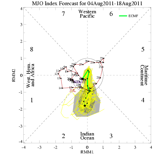
ECMWF Ensembles MJO forecast. Phase 1&2 are upward motion for the Atlantic
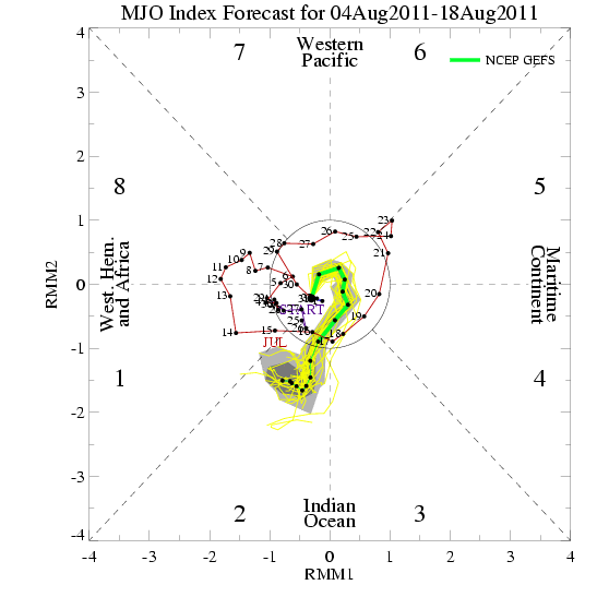
GFS Ensembles MJO forecast is very close to the Euro.
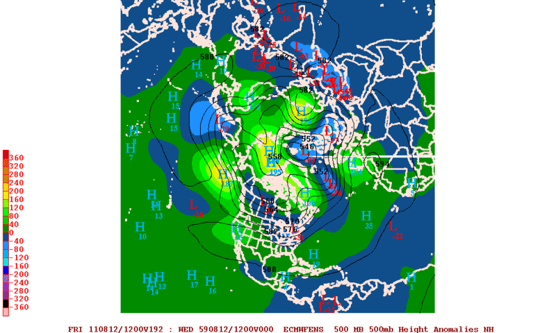
ECMWF Ensembles forecast below normal 500mb heights by the end of next week in Hurricane Alley. That is another sign that something may try to pop up.
ECMWF Ensembles MJO forecast. Phase 1&2 are upward motion for the Atlantic
GFS Ensembles MJO forecast is very close to the Euro.
ECMWF Ensembles forecast below normal 500mb heights by the end of next week in Hurricane Alley. That is another sign that something may try to pop up.
0 likes
The following post is NOT an official forecast and should not be used as such. It is just the opinion of the poster and may or may not be backed by sound meteorological data. It is NOT endorsed by any professional institution including storm2k.org For Official Information please refer to the NHC and NWS products.
-
cycloneye
- Admin
- Posts: 149515
- Age: 69
- Joined: Thu Oct 10, 2002 10:54 am
- Location: San Juan, Puerto Rico
Re: Global Model Runs Discussion
GFS continues to show the wave that is now in Central Africa trying to develop.
http://moe.met.fsu.edu/cgi-bin/gfstc2.c ... =Animation
http://moe.met.fsu.edu/cgi-bin/gfstc2.c ... =Animation
0 likes
Visit the Caribbean-Central America Weather Thread where you can find at first post web cams,radars
and observations from Caribbean basin members Click Here
and observations from Caribbean basin members Click Here
-
alan1961
- Category 2
- Posts: 771
- Joined: Mon Mar 20, 2006 11:58 am
- Location: Derby, Derbyshire, England
- Contact:
Re: Global Model Runs Discussion
Hmmm..where are you possible Franklyn?  2 potential areas
to watch over Central Africa.

GFS still showing something next week at 72 hours.

to watch over Central Africa.

GFS still showing something next week at 72 hours.

0 likes
-
AJC3

- Admin
- Posts: 4156
- Age: 62
- Joined: Tue Aug 31, 2004 7:04 pm
- Location: Ballston Spa, New York
- Contact:
There's a pretty decent signal from all the globals I looked at that a low will be trying to spin up in the deep tropics somewhere in the neighborhood of 12-13N and 21-25W in about 60 hours (SUN evening, 8 PM). METEOSAT shows a large area of positive voticity over the east Atlantic centered along 12N with embedded maxes around 30W, 10-12W, and 0-3E. It sort of resembles a WPAC monsoon trough, though not nearly as convectively active this morning.
The CV season looks like it's shifting into it's August-September mode right on schedule.
The CV season looks like it's shifting into it's August-September mode right on schedule.
0 likes
Who is online
Users browsing this forum: No registered users and 34 guests