ATL: EMILY - Remnants
Moderator: S2k Moderators
-
stormreader
Re: ATL: EMILY - Remnants - Discussion
Yeah, and looking at it again, there is a north component to the whole area (not just west) so perhaps the better area to look (instead of south of Cuba) would in fact be the Turks and Caicos or the extreme southern Bahamas. But I think the NHC forecast of probable regeneration (60%) is solid.
0 likes

Re: ATL: EMILY - Remnants - Discussion
I'm gonna move my blue circle a little farther wnw. This is the area I see the most vorticity but it's in a pocket of dry air and flow is being disrupted by cuba and Jamicia.

Uploaded with ImageShack.us

Uploaded with ImageShack.us
0 likes
The following post is NOT an official forecast and should not be used as such. It is just the opinion of the poster and may or may not be backed by sound meteorological data. It is NOT endorsed by any professional institution including storm2k.org For Official Information please refer to the NHC and NWS products.
-
tolakram
- Admin

- Posts: 20186
- Age: 62
- Joined: Sun Aug 27, 2006 8:23 pm
- Location: Florence, KY (name is Mark)
Re: ATL: EMILY - Remnants - Discussion
MIMIC-TPW still looks good: http://cimss.ssec.wisc.edu/tropic/real- ... /main.html
Circulation has not collapsed or been squished or absorbed so now all is needed is something at the surface. Center (of moisture circulation) appears to be right at NE Cuba.
Circulation has not collapsed or been squished or absorbed so now all is needed is something at the surface. Center (of moisture circulation) appears to be right at NE Cuba.
0 likes
M a r k
- - - - -
Join us in chat: Storm2K Chatroom Invite. Android and IOS apps also available.
The posts in this forum are NOT official forecasts and should not be used as such. Posts are NOT endorsed by any professional institution or STORM2K.org. For official information and forecasts, please refer to NHC and NWS products.
-
cycloneye

- Admin
- Posts: 149505
- Age: 69
- Joined: Thu Oct 10, 2002 10:54 am
- Location: San Juan, Puerto Rico
Re: ATL: EMILY - Remnants - Discussion
TROPICAL WEATHER OUTLOOK
NWS NATIONAL HURRICANE CENTER MIAMI FL
800 AM EDT FRI AUG 5 2011
FOR THE NORTH ATLANTIC...CARIBBEAN SEA AND THE GULF OF MEXICO...
A SURFACE TROUGH...THE REMNANTS OF FORMER TROPICAL STORM EMILY...IS
PRODUCING A LARGE AREA OF CLOUDINESS AND THUNDERSTORMS EXTENDING
FROM EASTERN CUBA NORTHEASTWARD ACROSS THE SOUTHEASTERN BAHAMAS.
THIS SYSTEM REMAINS DISORGANIZED BUT UPPER-LEVEL WINDS ARE EXPECTED
TO BECOME A LITTLE MORE FAVORABLE FOR DEVELOPMENT ON SATURDAY.
THIS SYSTEM HAS A HIGH CHANCE...60 PERCENT...OF REGENERATING INTO A
TROPICAL CYCLONE DURING THE NEXT 48 HOURS AS IT MOVES TOWARD THE
NORTHWEST AND NORTHWARD AT 15 MPH..
ELSEWHERE...TROPICAL CYCLONE FORMATION IS NOT EXPECTED DURING THE
NEXT 48 HOURS.
$$
FORECASTER AVILA
0 likes
Visit the Caribbean-Central America Weather Thread where you can find at first post web cams,radars
and observations from Caribbean basin members Click Here
and observations from Caribbean basin members Click Here
-
Gustywind

- Category 5

- Posts: 12334
- Joined: Mon Sep 03, 2007 7:29 am
- Location: Baie-Mahault, GUADELOUPE
000
AXNT20 KNHC 051152
TWDAT
TROPICAL WEATHER DISCUSSION
NWS NATIONAL HURRICANE CENTER MIAMI FL
805 AM EDT FRI AUG 05 2011
TROPICAL WEATHER DISCUSSION FOR NORTH AMERICA...CENTRAL
AMERICA...GULF OF MEXICO...CARIBBEAN SEA...NORTHERN SECTIONS OF
SOUTH AMERICA...AND ATLANTIC OCEAN TO THE AFRICAN COAST FROM THE
EQUATOR TO 32N. THE FOLLOWING INFORMATION IS BASED ON SATELLITE
IMAGERY...WEATHER OBSERVATIONS...RADAR...AND METEOROLOGICAL
ANALYSIS.
BASED ON 0600 UTC SURFACE ANALYSIS AND SATELLITE IMAGERY THROUGH
1015 UTC.
...SPECIAL FEATURES...
THE REMNANTS OF EMILY IN THE FORM OF A SURFACE TROUGH IS
ANALYZED FROM THE SE BAHAMAS NEAR 23N74W ACROSS THE E TIP OF
CUBA ALONG 19N76W OVER JAMAICA TO NEAR 17N79W. SCATTERED TO
HEAVY SHOWERS/ISOLATED THUNDERSTORMS ARE FROM 19N-21N W OF THE
TROUGH AXIS TO 78W. A BROAD AREA OF DENSE CLOUD COVER WITH
SCATTERED SHOWERS AND POSSIBLE ISOLATED THUNDERSTORMS COVER THE
N CENTRAL CARIBBEAN/SW ATLC WITHIN 120 NM OF LINE FROM THE S TIP
OF HAITI NEAR 18N74W INTO THE W ATLC NEAR 25N66W INCLUDING
PORTIONS OF HISPANIOLA...E CUBA...THE TURKS AND CAICOS...AND SE
BAHAMAS.
THIS SYSTEM REMAINS DISORGANIZED BUT UPPER-LEVEL WINDS ARE
EXPECTED TO BECOME A LITTLE MORE FAVORABLE FOR DEVELOPMENT ON
SATURDAY. IT IS POSSIBLE THAT THIS SYSTEM MAY REGENERATE INTO
A TROPICAL CYCLONE DURING THE NEXT 48 HOURS AS IT MOVES
NORTHWESTWARD AND NORTHWARD 15 MPH..
$$
PAW
0 likes

Re: ATL: EMILY - Remnants - Discussion
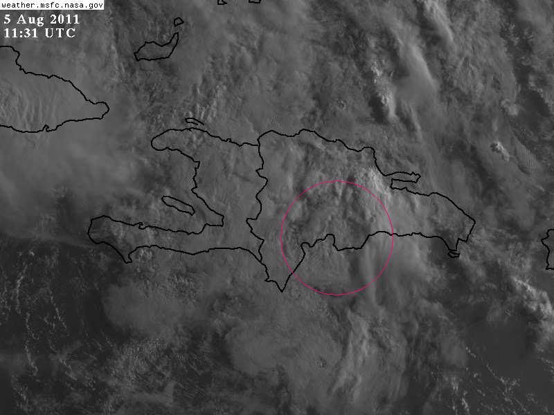
This is where I see spin this morning.
0 likes
The preceding comments are never to be used as information to establish circumstances, plans or procedures for any weather related events. Only use official National Hurricane Center or National Weather Service information issued for your area.


Re: ATL: EMILY - Remnants - Discussion
11:45Z VIS & Funktop


Last edited by TheBurn on Fri Aug 05, 2011 7:19 am, edited 1 time in total.
0 likes

Re: ATL: EMILY - Remnants - Discussion
TRMM has a hot-tower west off Gitmo Bay.
Even though mid-level circulation is moving into the Bahamas, I am watching between Cuba and Jamaica.

Even though mid-level circulation is moving into the Bahamas, I am watching between Cuba and Jamaica.
0 likes
Re: ATL: EMILY - Remnants - Discussion
Some turning seen east of the southeast Bahamas - we'll see what happens, though the entire area looks to be moving northward at a steady pace:
http://www.goes.noaa.gov/HURRLOOPS/huirloop.html
http://www.goes.noaa.gov/HURRLOOPS/huirloop.html
0 likes
Re: ATL: EMILY - Remnants - Discussion
Pretty strong cells along the SE Cuba shoreline as shown on Aqua's microwave imager.

0 likes
Re: ATL: EMILY - Remnants - Discussion
Morning everyone! would anyone suprised to see a depression status be assigned today to the remnants?
0 likes
-
Aric Dunn
- Category 5
- Posts: 21238
- Age: 43
- Joined: Sun Sep 19, 2004 9:58 pm
- Location: Ready for the Chase.
- Contact:
pretty good rotation north of CUBA.. no convection with it.. but that might change today.. still pretty good chance of redevelopment..
0 likes
Note: If I make a post that is brief. Please refer back to previous posts for the analysis or reasoning. I do not re-write/qoute what my initial post said each time.
If there is nothing before... then just ask
Space & Atmospheric Physicist, Embry-Riddle Aeronautical University,
I believe the sky is falling...
If there is nothing before... then just ask
Space & Atmospheric Physicist, Embry-Riddle Aeronautical University,
I believe the sky is falling...
-
AdamFirst

- S2K Supporter

- Posts: 2490
- Age: 36
- Joined: Thu Aug 14, 2008 10:54 am
- Location: Port Saint Lucie, FL
Re: ATL: EMILY - Remnants - Discussion
underthwx wrote:Morning everyone! would anyone suprised to see a depression status be assigned today to the remnants?
Today I'd be surprised. It's got a long way to go.
0 likes
Dolphins Marlins Canes Golden Panthers HEAT
Andrew 1992 - Irene 1999 - Frances 2004 - Jeanne 2004 - Wilma 2005 - Fay 2008 - Isaac 2012 - Matthew 2016 - Irma 2017 - Dorian 2019 - Ian 2022 - Nicole 2022 - Milton 2024
Andrew 1992 - Irene 1999 - Frances 2004 - Jeanne 2004 - Wilma 2005 - Fay 2008 - Isaac 2012 - Matthew 2016 - Irma 2017 - Dorian 2019 - Ian 2022 - Nicole 2022 - Milton 2024
-
Aric Dunn
- Category 5
- Posts: 21238
- Age: 43
- Joined: Sun Sep 19, 2004 9:58 pm
- Location: Ready for the Chase.
- Contact:
And it mostly heading WNW along the northern coast of CUBA similar to the GFS showing that weak vort. should head into florida over the next couple days.
0 likes
Note: If I make a post that is brief. Please refer back to previous posts for the analysis or reasoning. I do not re-write/qoute what my initial post said each time.
If there is nothing before... then just ask
Space & Atmospheric Physicist, Embry-Riddle Aeronautical University,
I believe the sky is falling...
If there is nothing before... then just ask
Space & Atmospheric Physicist, Embry-Riddle Aeronautical University,
I believe the sky is falling...
-
stormreader
Re: ATL: EMILY - Remnants - Discussion

And even though the towers are firing in E Cuba, their is a north component to the whole system and I notice that the convection is increasing now north of Cuba in the southern Bahamas closer to where a possible Mid Level Center is located. I think you have to look along the north coast of Cuba---southern Bahamas area for development beginning tomorrow. My Opinion.
0 likes
BTW, the convection in SE Cuba is just from the convergence & lifting., SE winds are being lifted up by the mountains in SE Cuba which run parallel to the coast. There is nothing happening there. Look where they placed the best track position. That's where the surface vorticity is this morning.
0 likes
-
Aric Dunn
- Category 5
- Posts: 21238
- Age: 43
- Joined: Sun Sep 19, 2004 9:58 pm
- Location: Ready for the Chase.
- Contact:
Re:
NDG wrote:They are going to be starting the tropical models closer to the surface trough than by the mid level vorticity. It will interesting.
AL, 05, 2011080512, , BEST, 0, 220N, 765W,
yeah thats because the greatest vorticity and potential for a surface circ to take shape once convection can fire.. that the area I just mentioned.
0 likes
Note: If I make a post that is brief. Please refer back to previous posts for the analysis or reasoning. I do not re-write/qoute what my initial post said each time.
If there is nothing before... then just ask
Space & Atmospheric Physicist, Embry-Riddle Aeronautical University,
I believe the sky is falling...
If there is nothing before... then just ask
Space & Atmospheric Physicist, Embry-Riddle Aeronautical University,
I believe the sky is falling...
Who is online
Users browsing this forum: No registered users and 64 guests