Here is todays TCPOD for Sunday and there will be only one mission left after this afternoons
flight. Look at the header that I highlighted.
NOUS42 KNHC 061530
WEATHER RECONNAISSANCE FLIGHTS
CARCAH, NATIONAL HURRICANE CENTER, MIAMI, FL.
1130 AM EDT SAT 06 AUGUST 2011
SUBJECT: TROPICAL CYCLONE PLAN OF THE DAY (TCPOD)
VALID 07/1100Z TO 08/1100Z AUGUST 2011
TCPOD NUMBER.....11-067
I. ATLANTIC REQUIREMENTS
1. TROPICAL STORM EMILY
FLIGHT ONE -- TEAL 70
A. 07/1800Z
B. AFXXX 1505A EMILY
C. 07/1500Z
D. 30.5N 75.2W
E. 07/1730Z TO 07/2200Z
F. SFC TO 10,000 FT
2. OUTLOOK FOR SUCCEEDING DAY.....NEGATIVE
ATL: EMILY - Remnants
Moderator: S2k Moderators
-
cycloneye

- Admin

- Posts: 149430
- Age: 69
- Joined: Thu Oct 10, 2002 10:54 am
- Location: San Juan, Puerto Rico
Re: ATL: Ex EMILY - Recon
0 likes
Visit the Caribbean-Central America Weather Thread where you can find at first post web cams,radars
and observations from Caribbean basin members Click Here
and observations from Caribbean basin members Click Here

Center seems to be getting better organized - movement more west than anything else, from this Sat loop
http://www.ssd.noaa.gov/goes/flt/t2/loop-bd.html
That "tounge"/protrusion ( the N.E. Quadrant) -I believe is that "other Low" that has been connected to main low -from the start. ( both been fighting each other) Emily's signature look
http://www.ssd.noaa.gov/goes/flt/t2/loop-bd.html
That "tounge"/protrusion ( the N.E. Quadrant) -I believe is that "other Low" that has been connected to main low -from the start. ( both been fighting each other) Emily's signature look
0 likes
-
maxx9512
- Tropical Storm

- Posts: 114
- Age: 66
- Joined: Thu May 31, 2007 7:55 pm
- Location: Cape Coral, Fl.
Re: ATL: EMILY - Remnants - Discussion
Looking at the Carib. visable loop it looks to be moving closer to Fl.
Is that just the cloud tops blowing off in that direction?
http://www.ssd.noaa.gov/goes/east/carb/flash-vis.html
Is that just the cloud tops blowing off in that direction?
http://www.ssd.noaa.gov/goes/east/carb/flash-vis.html
0 likes
-
SouthDadeFish

- Professional-Met

- Posts: 2835
- Joined: Thu Sep 23, 2010 2:54 pm
- Location: Miami, FL
- Contact:
-
tolakram
- Admin
- Posts: 20185
- Age: 62
- Joined: Sun Aug 27, 2006 8:23 pm
- Location: Florence, KY (name is Mark)
Re: ATL: EMILY - Remnants - Discussion
I think Emily is gone, squished and carried out to sea. Whatever that good looking blob is must be an imposter.
Live loop:

Personal Forecast Disclaimer:
The posts in this forum are NOT official forecast and should not be used as such. They are just the opinion of the poster and may or may not be backed by sound meteorological data. They are NOT endorsed by any professional institution or storm2k.org. For official information, please refer to the NHC and NWS products.
Live loop:
Personal Forecast Disclaimer:
The posts in this forum are NOT official forecast and should not be used as such. They are just the opinion of the poster and may or may not be backed by sound meteorological data. They are NOT endorsed by any professional institution or storm2k.org. For official information, please refer to the NHC and NWS products.
0 likes
M a r k
- - - - -
Join us in chat: Storm2K Chatroom Invite. Android and IOS apps also available.
The posts in this forum are NOT official forecasts and should not be used as such. Posts are NOT endorsed by any professional institution or STORM2K.org. For official information and forecasts, please refer to NHC and NWS products.
-
SouthDadeFish
- Professional-Met
- Posts: 2835
- Joined: Thu Sep 23, 2010 2:54 pm
- Location: Miami, FL
- Contact:
From Miami NWS:
000
FXUS62 KMFL 061430
AFDMFL
AREA FORECAST DISCUSSION
NATIONAL WEATHER SERVICE MIAMI FL
1030 AM EDT SAT AUG 6 2011
.UPDATE...
ONLY A FEW MINOR UPDATES WERE NEEDED THIS MORNING BASED ON THE
LATEST TRENDS AND OBSERVATIONS AROUND THE LOCAL AREA. THE LATEST
SURFACE ANALYSIS AND RADAR LOOP SHOWED THE CENTER OF THE REMNANTS
OF TROPICAL STORM EMILY LOCATED OVER THE BAHAMAS...JUST EAST OF
OUR OFFSHORE ATLANTIC WATERS WITH LIGHT NORTHEAST WINDS STREAMING
OVER THE AREA. RECENTLY ANIMATED SATELLITE IMAGERY SHOWED
CONVECTION CONTINUING TO FLARE NEAR THE LOW-LEVEL CIRCULATION
CENTER WITH CLOUD TOP TEMPERATURES APPROACHING -80 AND THE
COVERAGE SLOWLY EXPANDING WEST INTO OUR OFFSHORE WATERS. AS THE
LOW CONTINUES TO LIFT NORTH OVER THE BAHAMAS...THE LOCAL FLOW WILL
STEADILY BACK TOWARD THE WESTERLY DIRECTION. SLIGHTLY ADJUSTED
CLOUD COVERAGE AND RAIN CHANCES WITH THE HIGHEST OVER THE EASTERN
HALF OF THE LOCAL AREA THIS AFTERNOON AND TONIGHT. OTHERWISE...THE
PREVIOUS FORECAST REMAINS ON TRACK AT THIS TIME. 85/AG
0 likes
-
SouthDadeFish
- Professional-Met
- Posts: 2835
- Joined: Thu Sep 23, 2010 2:54 pm
- Location: Miami, FL
- Contact:

Re: Re:
NDG wrote:artist wrote:Bimini Islands have a calm wind which is located just a tad northwest of Andros Island. 29.97 Pressure
I see the only wx station through wunderground reporting NW to W winds all morning long, currently out of the west.
http://www.wunderground.com/weatherstation/WXDailyHistory.asp?ID=IBIMINIA2
yeah, NDG, I got that from the BAhamas met page and noticed they did not have any time on it at all, so it could very well be iffy
0 likes
-
floridasun78
- Category 5

- Posts: 3755
- Joined: Sun May 17, 2009 10:16 pm
- Location: miami fl


Re:
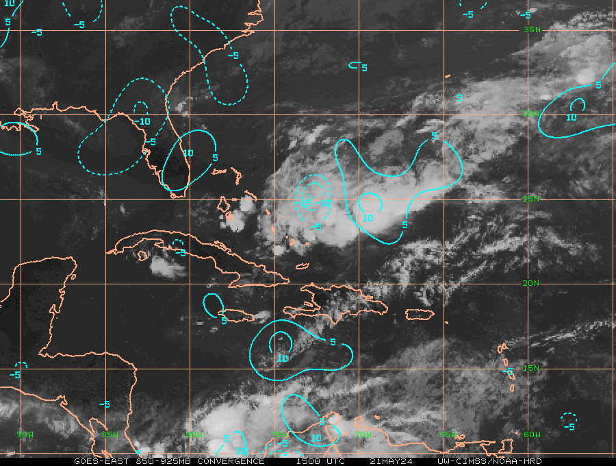
SouthDadeFish wrote:CIMSS suggesting convergence and divergence is increasing, and the 850mb vorticity doesn't look too elongated either.
Yeah, compared to late last night and the very early morning, is better.
0 likes
-
SouthDadeFish
- Professional-Met
- Posts: 2835
- Joined: Thu Sep 23, 2010 2:54 pm
- Location: Miami, FL
- Contact:
-
SouthDadeFish
- Professional-Met
- Posts: 2835
- Joined: Thu Sep 23, 2010 2:54 pm
- Location: Miami, FL
- Contact:

-
cycloneye
- Admin
- Posts: 149430
- Age: 69
- Joined: Thu Oct 10, 2002 10:54 am
- Location: San Juan, Puerto Rico
Re:
SouthDadeFish wrote:Why hasn't recon taken off yet?
I am speculating here,but maybe plane may depart from a closer base than Biloxi or St Croix.
0 likes
Visit the Caribbean-Central America Weather Thread where you can find at first post web cams,radars
and observations from Caribbean basin members Click Here
and observations from Caribbean basin members Click Here
-
SouthDadeFish
- Professional-Met
- Posts: 2835
- Joined: Thu Sep 23, 2010 2:54 pm
- Location: Miami, FL
- Contact:
Re: Re:
cycloneye wrote:SouthDadeFish wrote:Why hasn't recon taken off yet?
I am speculating here,but maybe plane may depart from a closer base than Biloxi or St Croix.
Don't they have one in Tampa?
0 likes


Who is online
Users browsing this forum: No registered users and 17 guests