This is why we have to look with caution the runs at long range. At 12z GFS,it had a strong hurricane knocking the door off the Carolinas. Now at the 18z run,a huge swing from that as it enters the GOM ending in Texas.
8/6/11 run of 18z GFS Loop
Global model runs discussion
Moderator: S2k Moderators
-
cycloneye

- Admin

- Posts: 149515
- Age: 69
- Joined: Thu Oct 10, 2002 10:54 am
- Location: San Juan, Puerto Rico
Re: Global Model Runs Discussion
0 likes
Visit the Caribbean-Central America Weather Thread where you can find at first post web cams,radars
and observations from Caribbean basin members Click Here
and observations from Caribbean basin members Click Here
-
Ivanhater

- Storm2k Moderator

- Posts: 11221
- Age: 39
- Joined: Fri Jul 01, 2005 8:25 am
- Location: Pensacola
Global Model Runs Discussion
Massive hurricane in the Gulf for the system still over Africa right now
http://raleighwx.americanwx.com/models/ ... cal384.gif
http://raleighwx.americanwx.com/models/ ... cal384.gif
0 likes
Michael
-
HURAKAN

- Professional-Met

- Posts: 46084
- Age: 39
- Joined: Thu May 20, 2004 4:34 pm
- Location: Key West, FL
- Contact:
Re: Global Model Runs Discussion
Ivanhater wrote:Massive hurricane in the Gulf for the system still over Africa right now
http://raleighwx.americanwx.com/models/ ... cal384.gif
LALALAND territory
0 likes
-
cycloneye
- Admin
- Posts: 149515
- Age: 69
- Joined: Thu Oct 10, 2002 10:54 am
- Location: San Juan, Puerto Rico
Re: Global Model Runs Discussion
Ivanhater wrote:Massive hurricane in the Gulf for the system still over Africa right now
http://raleighwx.americanwx.com/models/ ... cal384.gif
Those members that live in Texas will open bigtime their eyes when they see this. The good thing about it is that is long range and it can swing back towards off the Carolinas.
0 likes
Visit the Caribbean-Central America Weather Thread where you can find at first post web cams,radars
and observations from Caribbean basin members Click Here
and observations from Caribbean basin members Click Here
-
Ivanhater
- Storm2k Moderator
- Posts: 11221
- Age: 39
- Joined: Fri Jul 01, 2005 8:25 am
- Location: Pensacola
Re: Global Model Runs Discussion
HURAKAN wrote:Ivanhater wrote:Massive hurricane in the Gulf for the system still over Africa right now
http://raleighwx.americanwx.com/models/ ... cal384.gif
LALALAND territory
This whole thread is dedicated to LALALAND
0 likes
Michael
-
Rgv20

- S2K Supporter

- Posts: 2466
- Age: 39
- Joined: Wed Jan 05, 2011 5:42 pm
- Location: Edinburg/McAllen Tx
Re: Global Model Runs Discussion
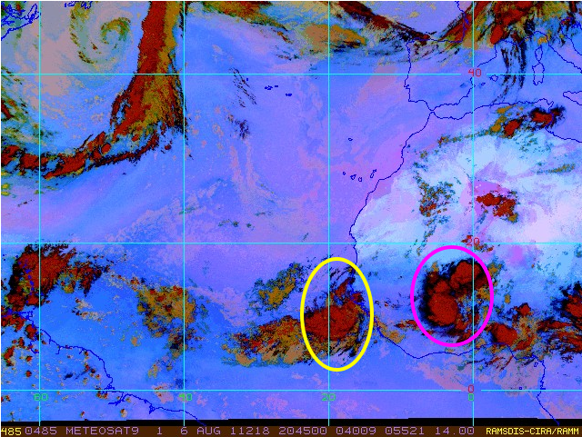
cycloneye wrote:This is why we have to look with caution the runs at long range. At 12z GFS,it had a strong hurricane knocking the door off the Carolinas. Now at the 18z run,a huge swing from that as it enters the GOM ending in Texas.
8/6/11 run of 18z GFS Loop
Looks to me that the first wave (circle in yellow) recurves between Bermuda and the East Coast and the second wave (pink circle) develops near the Lesser Antilles and tracks to the GOM.
0 likes
The following post is NOT an official forecast and should not be used as such. It is just the opinion of the poster and may or may not be backed by sound meteorological data. It is NOT endorsed by any professional institution including storm2k.org For Official Information please refer to the NHC and NWS products.

Also system that is currently just out of Africa ends up being an east coast threat after coming up through the Caribbean, nearly identical in track to Emily.
Edit---It actually takes the exact same track, thats uncanny!
Edit---It actually takes the exact same track, thats uncanny!
0 likes
Personal Forecast Disclaimer:
The posts in this forum are NOT official forecast and should not be used as such. They are just the opinion of the poster and may or may not be backed by sound meteorological data. They are NOT endorsed by any professional institution or storm2k.org. For official information, please refer to the NHC and NWS products
The posts in this forum are NOT official forecast and should not be used as such. They are just the opinion of the poster and may or may not be backed by sound meteorological data. They are NOT endorsed by any professional institution or storm2k.org. For official information, please refer to the NHC and NWS products

Re:
KWT wrote:Also system that is currently just out of Africa ends up being an east coast threat after coming up through the Caribbean, nearly identical in track to Emily.
Edit---It actually takes the exact same track, thats uncanny!
Cue the Twilight Zone opening song.
[youtube]http://www.youtube.com/watch?v=-b5aW08ivHU[/youtube]
0 likes
Re:
Uncanny the paths that the systems that would become Cindy and Emily took from the eastern atlantic to around haiti....pretty much identical. Is that a sign of a steering pattern that will become a theme this season?
The tracks so far this season do show some trends....systems moving wnw across the yucatan into mexico and systems developing near the bahamas and turning north and east.

The tracks so far this season do show some trends....systems moving wnw across the yucatan into mexico and systems developing near the bahamas and turning north and east.
KWT wrote:Also system that is currently just out of Africa ends up being an east coast threat after coming up through the Caribbean, nearly identical in track to Emily.
Edit---It actually takes the exact same track, thats uncanny!
0 likes

Re: Global Model Runs Discussion
The posts in this forum are NOT official forecast and should not be used as such. They are just the opinion of the poster and may or may not be backed by sound meteorological data. They are NOT endorsed by any professional institution or storm2k.org. For official information, please refer to the NHC and NWS products.
I think it's very important to note that the GFS is very good forecasting cyclogenesis of Cape Verde systems in the long range, sometimes it is good forecasting intensity and it is not that good with the track (in the long range) as it tends to send every major hurricane into the Gulf of Mexico. In conclusion if it is consistent in the next few days it is very likely that something will develop but the track could change a lot so everybody needs to watch it.
I think it's very important to note that the GFS is very good forecasting cyclogenesis of Cape Verde systems in the long range, sometimes it is good forecasting intensity and it is not that good with the track (in the long range) as it tends to send every major hurricane into the Gulf of Mexico. In conclusion if it is consistent in the next few days it is very likely that something will develop but the track could change a lot so everybody needs to watch it.
0 likes
-
OuterBanker
- S2K Supporter
- Posts: 1761
- Joined: Wed Feb 26, 2003 10:53 am
- Location: Nags Head, NC
- Contact:
-
cycloneye
- Admin
- Posts: 149515
- Age: 69
- Joined: Thu Oct 10, 2002 10:54 am
- Location: San Juan, Puerto Rico
Re: Global Model Runs Discussion
Macrocane wrote:The posts in this forum are NOT official forecast and should not be used as such. They are just the opinion of the poster and may or may not be backed by sound meteorological data. They are NOT endorsed by any professional institution or storm2k.org. For official information, please refer to the NHC and NWS products.
I think it's very important to note that the GFS is very good forecasting cyclogenesis of Cape Verde systems in the long range, sometimes it is good forecasting intensity and it is not that good with the track (in the long range) as it tends to send every major hurricane into the Gulf of Mexico. In conclusion if it is consistent in the next few days it is very likely that something will develop but the track could change a lot so everybody needs to watch it.
You are correct on that. The best example was todays 12z and 18z runs by GFS that had a hurricane off the Carolinas at 12z to a hurricane making landfall in Texas at 18z. But the important thing is to keep watching the models for consistency as the timeframes advance on run by run from GFS and the other ones.
0 likes
Visit the Caribbean-Central America Weather Thread where you can find at first post web cams,radars
and observations from Caribbean basin members Click Here
and observations from Caribbean basin members Click Here
-
cycloneye
- Admin
- Posts: 149515
- Age: 69
- Joined: Thu Oct 10, 2002 10:54 am
- Location: San Juan, Puerto Rico
Re: Pouch P14L- Off Africa coast
It looks like after mid August,the NAO will turn positive,meaning less recurvature and more Caribbean threats.

Uploaded by Imageshack.us
Uploaded by Imageshack.us
0 likes
Visit the Caribbean-Central America Weather Thread where you can find at first post web cams,radars
and observations from Caribbean basin members Click Here
and observations from Caribbean basin members Click Here
-
CYCLONE MIKE
- Category 5

- Posts: 2183
- Joined: Tue Aug 31, 2004 6:04 pm
- Location: Gonzales, LA
Re: Global Model Runs Discussion
Macrocane wrote:The posts in this forum are NOT official forecast and should not be used as such. They are just the opinion of the poster and may or may not be backed by sound meteorological data. They are NOT endorsed by any professional institution or storm2k.org. For official information, please refer to the NHC and NWS products.
I think it's very important to note that the GFS is very good forecasting cyclogenesis of Cape Verde systems in the long range, sometimes it is good forecasting intensity and it is not that good with the track (in the long range) as it tends to send every major hurricane into the Gulf of Mexico. In conclusion if it is consistent in the next few days it is very likely that something will develop but the track could change a lot so everybody needs to watch it.
Actually Macro the GFS usually tries and recurve the long trackers well before reaching any land. Usually between the US east coast and Bermuda. Then of course keeps shifting west to make up for its early recurvature every run. Heck if the GFS was showing a hurricance hitting my area of Louisiana in 4 -5 days I would blow it off and just laugh. Don't trust anything it shows from mid to long range, sometimes even shorter range.
0 likes
-
StormClouds63
- Category 2

- Posts: 583
- Age: 62
- Joined: Tue May 13, 2008 11:56 am
- Location: Southwest Louisiana
Re: Global Model Runs Discussion
So if these 2 scenarios play out, Franklin is a fish, and Gert is a U.S. threat.
0 likes

Re: Global Model Runs Discussion
Ivanhater wrote:Massive hurricane in the Gulf for the system still over Africa right now
http://raleighwx.americanwx.com/models/ ... cal384.gif
Landfall @ 384 hours, its a 50 kt tropical storm. That's way out it in GFS fantasy land, but I sure hope it comes to pass, my lawn and slab need it badly.


0 likes
-
maxintensity
- Tropical Storm

- Posts: 165
- Joined: Tue Aug 02, 2011 9:54 pm
Re: Global Model Runs Discussion
waveaxis wrote:Landfall @ 384 hours, its a 50 kt tropical storm. That's way out it in GFS fantasy land, but I sure hope it comes to pass, my lawn and slab need it badly.
Global models can not be translated for intensity like that. One should only look at the environment depicted by the global model and the fact that it shows a healthy system. A global model might show a major hurricane as a broad area of low pressure.
0 likes

Re: Global Model Runs Discussion
Hello folks, looks like things could get interesting down the road! wow. 
I'd like to add some of my insight: I believe and have been stating days ago that the dates from August 15th-19th should be very important regarding a hurricane. I don't know if this coincides perfectly with the Carolina hurricane threat seen by the models, but I am pretty confident we may see something between those days...perhaps a hit on PR around the 15th-16th and maybe another whack (Bahamas of Carolinas after on 8/18-19. This is based on a private, personal method I'm working on and this thread caught my attention. I feel the need to post about this on here, I guess you can call this a gut feeling/
After that, August 22nd-27th looks like it could provide another hurricane event. Just wanted to share this with you all. It's really out on a limb, and a bit daring to say. I could be wrong, but seeing the models hinting at "stuff" going on around these dates makes me think I'm onto something. I'm gonna need the disclaimer now lol
The posts in this forum are NOT official forecast and should not be used as such. They are just the opinion of the poster and may or may not be backed by sound meteorological data. They are NOT endorsed by any professional institution or storm2k.org. For official information, please refer to the NHC and NWS products.
0 likes
Georges '98, Irene '99, Frances '04, Jeanne '04, Katrina '05, Wilma '05, Gustav '08, Isaac '12, Matthew '16, Florence '18, Michael '18, Ian '22
-
dwsqos2
Re: Global Model Runs Discussion
There wasn't much on the 0Z gfs. Maybe the borefest just continues.
Last edited by dwsqos2 on Sun Aug 07, 2011 12:17 am, edited 1 time in total.
0 likes
-
Florida1118
Re: Global Model Runs Discussion
dwsqos2 wrote:Ther wasn't much on the 0Z gfs. Maybe the borefest just continues.
Thats the Spirit! IMO there Will be Gert in the next few days, TWO should have it by 8pm tomorrow
0 likes
Who is online
Users browsing this forum: No registered users and 43 guests