This late July/Early August ones usually look like they're developing at night and fall apart during the day and repeat 7 times.
I'm predicting >96 hours of code orange or red during its trek.
ATL: Ex INVEST 92L - Discussion
Moderator: S2k Moderators

Might be too early to tell, but with no real change in the pattern during next week I will not be surprised if 92L takes a very similar track of that of Emily, at least through the Caribbean.
Both ECMWF & GFS show a 594+ dm H50 ridge to come off of Africa to the north of 92L that will keep it on a westerly course through the Atlantic with no sign of recurving east of the Windward & Leeward Islands.
Personal Forecast Disclaimer:
The posts in this forum are NOT official forecast and should not be used as such. They are just the opinion of the poster and may or may not be backed by sound meteorological data. They are NOT endorsed by any professional institution or storm2k.org. For official information, please refer to the NHC and NWS products
0 likes
-
Kory
- Tropical Storm

- Posts: 200
- Age: 30
- Joined: Tue Aug 02, 2011 11:32 am
- Location: New Orleans, Louisiana
Re:
NDG wrote:Might be too early to tell, but with no real change in the pattern during next week I will not be surprised if 92L takes a very similar track of that of Emily, at least through the Caribbean.
Both ECMWF & GFS show a 594+ dm H50 ridge to come off of Africa to the north of 92L that will keep it on a westerly course through the Atlantic with no sign of recurving east of the Windward & Leeward Islands.
Personal Forecast Disclaimer:
The posts in this forum are NOT official forecast and should not be used as such. They are just the opinion of the poster and may or may not be backed by sound meteorological data. They are NOT endorsed by any professional institution or storm2k.org. For official information, please refer to the NHC and NWS products
I have to agree NDG, this pattern has been dominant for most of the summer. I can see it re-curving before the East Coast, unless the system stays far enough to the south where it may end up in central American or Mexico.
The posts in this forum are NOT official forecast and should not be used as such. They are just the opinion of the poster and may or may not be backed by sound meteorological data. They are NOT endorsed by any professional institution or storm2k.org. For official information, please refer to the NHC and NWS products.
0 likes

Re: ATL: INVEST 92L - Discussion
i'll be honest and admit i haven't been following closely this summer but wow the SAL looks crazy right now, has it been that large all summer?
0 likes
-
cycloneye

- Admin

- Posts: 149366
- Age: 69
- Joined: Thu Oct 10, 2002 10:54 am
- Location: San Juan, Puerto Rico
Re: ATL: INVEST 92L - Discussion
CronkPSU wrote:i'll be honest and admit i haven't been following closely this summer but wow the SAL looks crazy right now, has it been that large all summer?
During June and July,there were less big sal outbreaks than what normally occur in those months.
0 likes
Visit the Caribbean-Central America Weather Thread where you can find at first post web cams,radars
and observations from Caribbean basin members Click Here
and observations from Caribbean basin members Click Here
-
lonelymike
- S2K Supporter

- Posts: 634
- Joined: Sat Jul 26, 2008 10:12 am
- Location: walton county fla
-
SouthFLTropics

- Category 5

- Posts: 4258
- Age: 50
- Joined: Thu Aug 14, 2003 8:04 am
- Location: Port St. Lucie, Florida
Re: ATL: INVEST 92L - Discussion
A bit off topic but I wonder if we will see another advisory this year from the NHC that says something to the effect "Franklin, the storm, not the forecaster"??? LOL
0 likes
Fourth Generation Florida Native
Personal Storm History: David 79, Andrew 92, Erin 95, Floyd 99, Irene 99, Frances 04, Jeanne 04, Wilma 05, Matthew 16, Irma 17, Ian 22, Nicole 22, Milton 24
Personal Storm History: David 79, Andrew 92, Erin 95, Floyd 99, Irene 99, Frances 04, Jeanne 04, Wilma 05, Matthew 16, Irma 17, Ian 22, Nicole 22, Milton 24
-
Scorpion
-
wxman57

- Moderator-Pro Met

- Posts: 23172
- Age: 68
- Joined: Sat Jun 21, 2003 8:06 pm
- Location: Houston, TX (southwest)
Re: ATL: INVEST 92L - Discussion
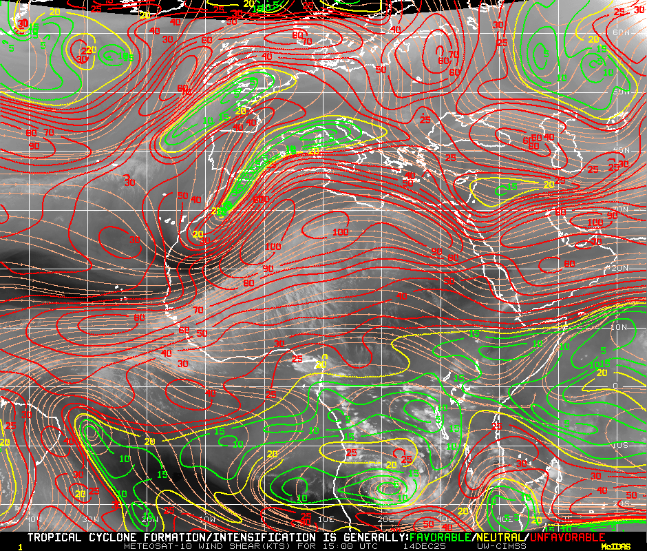
The east Atlantic may be a bit too hostile for development, still. Bermuda high shifted east but rather strong would mean strong low-level easterly flow east of 50W for a while. That's the reason for all the dry air north of 92L. This is a problem because the best convergence will come as it nears the Caribbean in 5-6 days. Farther west development means more of a threat to Caribbean and possibly the U.S. Ridge would probably hold firm over TX/LA for the next few weeks, so look for either a track south to NE MX or south TX (as per Arlene/Don) or similar to Emily.
0 likes
-
plasticup
Re: ATL: INVEST 92L - Discussion
lonelymike wrote:What are we talking? 12-15 days from the US?
It's a bit too early to even consider US threat. Especially with the Bermuda high receding east and not forecast to return in the medium-term, Cape Verde-type storms are looking more likely to recurve.
0 likes
Re: ATL: INVEST 92L - Discussion
Given the estimated location at 11.5N 19W, if this system averages a forward motion of 15 miles per hour, it will take approx these # days to reach:
San Juan - 9 days
Miami - 11-12 days
Houston - 14 days
If the forward motion is 12 miles per hour instead, it would take these many days to reach:
San Juan - 11 days
Miami - 14 days
Houston - 17-18 days
Alot came happen in that timeframe!!! (or not happen)
San Juan - 9 days
Miami - 11-12 days
Houston - 14 days
If the forward motion is 12 miles per hour instead, it would take these many days to reach:
San Juan - 11 days
Miami - 14 days
Houston - 17-18 days
Alot came happen in that timeframe!!! (or not happen)
lonelymike wrote:What are we talking? 12-15 days from the US?
0 likes

-
Jevo

- S2K Supporter
- Posts: 1729
- Age: 47
- Joined: Tue Aug 03, 2004 8:45 pm
- Location: The Flemish Cap
- Contact:
Hey look.. Its our good friend SAL! That guy has been nothing but a bully this year.. takin all our water and stuff.. 92L is going to have some dust to deal with till about 50L

0 likes
Disclaimer: 50% of the time I have no clue of what I am talking about. Chances are I am taking a less than educated guess that sounds good because 10 years ago I stole Mike Watkins book 'The Hurricane and its Impact'. For official information please direct yourself to the NHC and their cadre of weather geniuses.
-
hurricaneCW
- Category 5
- Posts: 1799
- Joined: Wed Mar 03, 2010 6:20 am
- Location: Toms River, NJ
Re: ATL: INVEST 92L - Discussion
That could be the danger this year, with SAL keeping these waves from really developing too early, they will have to wait until 50-60W and then develop which rapidly increase the U.S. threat potential rather than developing quickly like last season.
0 likes
-
HurricaneWarning92
- Category 2

- Posts: 520
- Joined: Sat Jul 23, 2011 4:33 pm
- Location: Pembroke Pines, S. Florida (Lat: 26.00N, Lon: 80.22W)
0 likes
The posts in this forum are NOT official forecast and should not be used as such. They are just the opinion of the poster and may or may not be backed by sound meteorological data. They are NOT endorsed by any professional institution or storm2k.org. For official information, please refer to the NHC and NWS products.
Re:
System can't die if they haven't yet developed...so basically they move west as weak systems, then once they get in more favorable conditions west of 50W, they are in someone's backyard.
HurricaneWarning92 wrote::uarrow: wow look at the dust north of PR and Hispaniola... Any storm going through there and it will have a slow painful death...
0 likes

Re: ATL: INVEST 92L - Discussion
I like what MIMIC-TPW is showing below 10N. Good west to east boundary layer flow. Could develop a good convergence which may setup a protected pouch.
Looks like it will have good amplitude.
Dakar time section currently showing a dry midlevel.
It may moisten as the convection at 10W merges.


Looks like it will have good amplitude.
Dakar time section currently showing a dry midlevel.
It may moisten as the convection at 10W merges.
0 likes
Re: ATL: INVEST 92L - Discussion
Interesting dicussion from Crown Weather this morning in regards to 92L and what role it could play in 'taking one for the team' for systems that follow it...
Possible Development Near The Lesser Antilles Later This Week (Invest 92L):
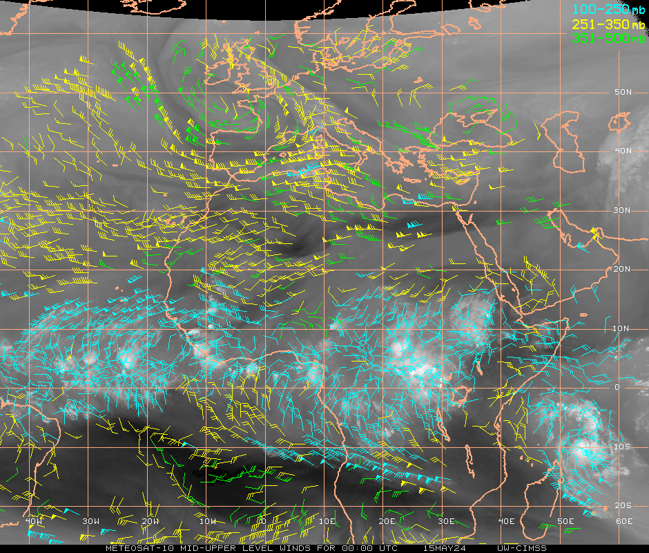
I am keeping an eye on a couple of tropical disturbances that exist from the eastern Atlantic into the African continent this morning. The first tropical disturbance, just very recently designated Invest 92L by the National Hurricane Center, was located to the south of the Cape Verde Islands. Satellite imagery over the last several hours show that convection is developing over this disturbance, however, the best vorticity is located to the north of the deeper convection. An analysis of the wind shear over Invest 92L indicates that this system is in a favorable shear environment, however, there is a large amount of dry air located just north of this system and I think it will be ingesting dry air as the wind flow from 32 West to 42 West Longitude is northeasterly and in the direction of all of the dry Saharan Air.
The global models like the GFS and European models forecast a westward track this week and forecast it to be entering the Caribbean as a weak system on Saturday. Looking at the overall environment from the coast of Africa to the Lesser Antilles, the environmental conditions are not all that favorable and really do not become favorable until 50 West Longitude and points west.
So, it is of my opinion that Invest 92L probably will not develop until it is west of 50 West Longitude which it’ll cross the 50 West Longitude line on Friday. From there, this system may track across the Lesser Antilles and into the eastern Caribbean early next Sunday.
Invest 92L will be monitored this week and there is more than plenty of time to keep an eye on it.
Tropical Disturbances Over African Continent That May Become Invest 93L:
Satellite imagery from the African continent show a robust tropical disturbance over western Africa near 9 West Longitude that is forecast to track into the far eastern Atlantic over the next couple of days. This disturbance has the potential to also develop later on down the road and the global models are more aggressive with developing this disturbance than Invest 92L. What may happen and this is a big may is that Invest 92L may clear a path for what may be Invest 93L by ingesting dry Saharan Air and moistening up the atmosphere and thus leaving a more favorable environment for future Invest 93L.
So, I will be keeping an eye on the disturbance over western Africa and will keep you all updated. Once again, there is more than plenty of time to keep an eye on it.
The next tropical weather discussion will be issued by 7 am EDT/6 am CDT Monday morning.
http://www.crownweather.com/?page_id=4557
Possible Development Near The Lesser Antilles Later This Week (Invest 92L):
I am keeping an eye on a couple of tropical disturbances that exist from the eastern Atlantic into the African continent this morning. The first tropical disturbance, just very recently designated Invest 92L by the National Hurricane Center, was located to the south of the Cape Verde Islands. Satellite imagery over the last several hours show that convection is developing over this disturbance, however, the best vorticity is located to the north of the deeper convection. An analysis of the wind shear over Invest 92L indicates that this system is in a favorable shear environment, however, there is a large amount of dry air located just north of this system and I think it will be ingesting dry air as the wind flow from 32 West to 42 West Longitude is northeasterly and in the direction of all of the dry Saharan Air.
The global models like the GFS and European models forecast a westward track this week and forecast it to be entering the Caribbean as a weak system on Saturday. Looking at the overall environment from the coast of Africa to the Lesser Antilles, the environmental conditions are not all that favorable and really do not become favorable until 50 West Longitude and points west.
So, it is of my opinion that Invest 92L probably will not develop until it is west of 50 West Longitude which it’ll cross the 50 West Longitude line on Friday. From there, this system may track across the Lesser Antilles and into the eastern Caribbean early next Sunday.
Invest 92L will be monitored this week and there is more than plenty of time to keep an eye on it.
Tropical Disturbances Over African Continent That May Become Invest 93L:
Satellite imagery from the African continent show a robust tropical disturbance over western Africa near 9 West Longitude that is forecast to track into the far eastern Atlantic over the next couple of days. This disturbance has the potential to also develop later on down the road and the global models are more aggressive with developing this disturbance than Invest 92L. What may happen and this is a big may is that Invest 92L may clear a path for what may be Invest 93L by ingesting dry Saharan Air and moistening up the atmosphere and thus leaving a more favorable environment for future Invest 93L.
So, I will be keeping an eye on the disturbance over western Africa and will keep you all updated. Once again, there is more than plenty of time to keep an eye on it.
The next tropical weather discussion will be issued by 7 am EDT/6 am CDT Monday morning.
http://www.crownweather.com/?page_id=4557
0 likes


Re: ATL: INVEST 92L - Discussion
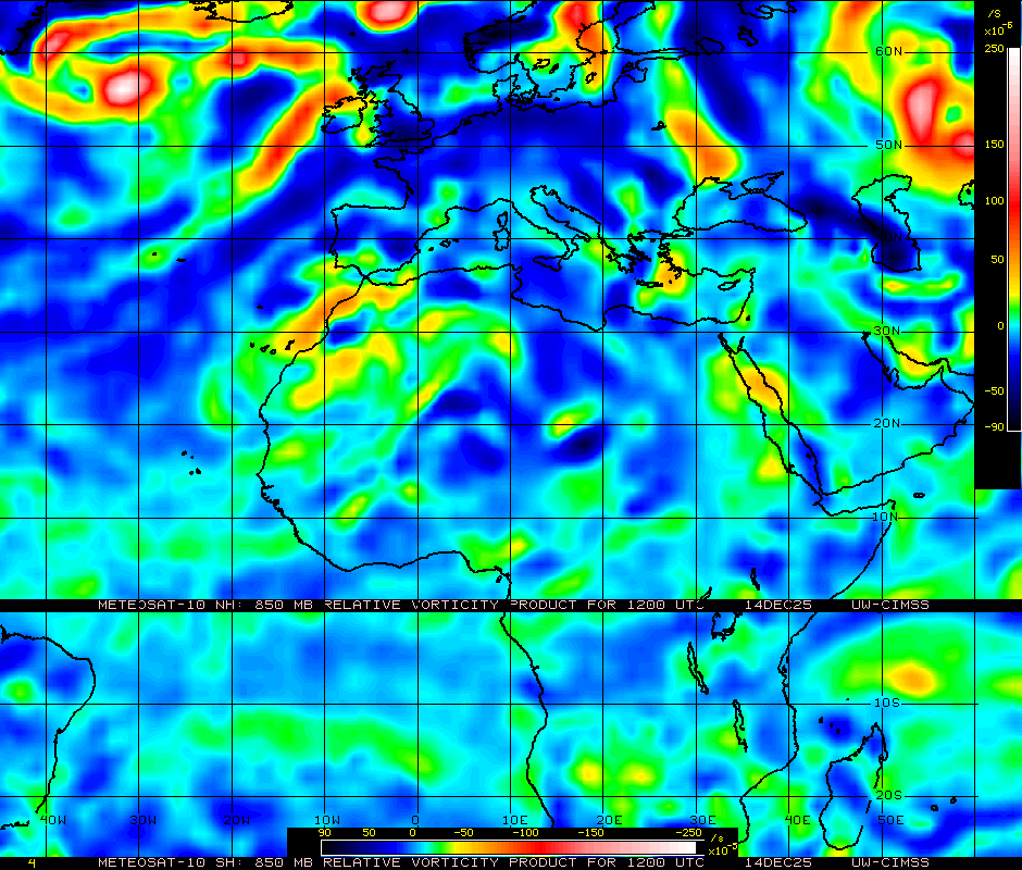
Good 850mb vorticity south of CV islands and good anti-cyclone & UL outflow with convection at 10W.
Could become potent if this melds together.

Could become potent if this melds together.
0 likes
Who is online
Users browsing this forum: No registered users and 45 guests