ATL: Ex INVEST 92L - Discussion

Moderator: S2k Moderators

Message
Author
HurricaneWarning92
Category 2
Category 2
Posts: 520
Joined: Sat Jul 23, 2011 4:33 pm
Location: Pembroke Pines, S. Florida (Lat: 26.00N, Lon: 80.22W)

Re: Re:

#201 Postby HurricaneWarning92 » Wed Aug 10, 2011 12:11 am

Rgv20 wrote:
HurricaneWarning92 wrote:
Rgv20 wrote::uarrow: oh I think the Forecast models would eventually correct themselves west with future runs. Its going to be interesting to see how much latitude it gains when it reaches 55W.


How so? will a ridge be building in westwards, not allowing it to recurve?


Looking at the 12zECMWF and GFS forecast 500mb heights the trough on the east coast is weakening from 8 thru 10 days and being replace by a ridge in south eastern canada represented by the light orange colors on the map. This could potentially but the east coast at risk if 92l were to develop and track to the south west Atlantic.

Image

Of course it is still way too early to forecast where 92l will track, just have to keep all options open at this point.


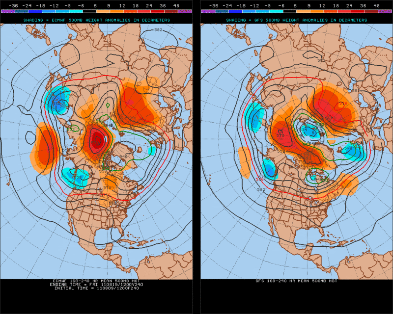
ah i see now... this is possibly what the pros were basing their predictions of.
0 likes   
The posts in this forum are NOT official forecast and should not be used as such. They are just the opinion of the poster and may or may not be backed by sound meteorological data. They are NOT endorsed by any professional institution or storm2k.org. For official information, please refer to the NHC and NWS products.

Florida1118

Re: ATL: INVEST 92L - Discussion

#202 Postby Florida1118 » Wed Aug 10, 2011 12:48 am

AN AREA OF DISTURBED WEATHER ASSOCIATED WITH A TROPICAL WAVE IS
LOCATED ABOUT 350 MILES SOUTHWEST OF THE SOUTHERN CAPE VERDE
ISLANDS. SLOW DEVELOPMENT OF THIS SYSTEM IS POSSIBLE OVER THE NEXT
COUPLE OF DAYS AS IT MOVES WESTWARD AT ABOUT 10 TO 15 MPH. THIS
SYSTEM HAS A LOW CHANCE...10 PERCENT...OF BECOMING A TROPICAL
CYCLONE DURING THE NEXT 48 HOURS.
0 likes   

User avatar
Kohlecane
Category 2
Category 2
Posts: 591
Age: 33
Joined: Sun Jul 31, 2011 11:03 pm
Location: Beaufort, SC

Re: ATL: INVEST 92L - Discussion

#203 Postby Kohlecane » Wed Aug 10, 2011 2:24 am

Keep the Percents coming
0 likes   
Once I see the REDS and GREENS Converge on a Base Velocity. ... I'm There!!

This is NOT an Official Forecast....Just my Opinion. For official information, please refer to the NHC and NWS products.
HIGHLIGHTS : '13 El Reno Tornado : 2013 Storm Chaser Tour, Joaquin; SC flood event, Matthew '16, Lowcountry Snow storm Jan '18

User avatar
KWT
Category 5
Category 5
Posts: 31415
Joined: Tue Aug 17, 2004 11:02 am
Location: UK!!!

#204 Postby KWT » Wed Aug 10, 2011 2:36 am

System does look like it has a decent shot at developing at some point...track should be a recurve, pattern is going to alter a little but probably not quickly and strongly enough for 92L imo.
0 likes   
Personal Forecast Disclaimer:
The posts in this forum are NOT official forecast and should not be used as such. They are just the opinion of the poster and may or may not be backed by sound meteorological data. They are NOT endorsed by any professional institution or storm2k.org. For official information, please refer to the NHC and NWS products

User avatar
ronjon
Category 5
Category 5
Posts: 4811
Joined: Fri Aug 19, 2005 5:17 pm
Location: Hernando Beach, FL

Re: ATL: INVEST 92L - Models

#205 Postby ronjon » Wed Aug 10, 2011 5:11 am

00z ECM shows a pretty close track to NC and New England from 92L.

Image
Last edited by ronjon on Wed Aug 10, 2011 7:33 am, edited 1 time in total.
0 likes   

User avatar
GCANE
S2K Supporter
S2K Supporter
Posts: 11453
Joined: Mon Oct 22, 2007 8:03 am

Re: ATL: INVEST 92L - Discussion

#206 Postby GCANE » Wed Aug 10, 2011 5:58 am

Latest ASCAT looks better.

Image
0 likes   

User avatar
ronjon
Category 5
Category 5
Posts: 4811
Joined: Fri Aug 19, 2005 5:17 pm
Location: Hernando Beach, FL

Re: ATL: INVEST 92L - Models

#207 Postby ronjon » Wed Aug 10, 2011 6:06 am

0 likes   

User avatar
GCANE
S2K Supporter
S2K Supporter
Posts: 11453
Joined: Mon Oct 22, 2007 8:03 am

Re: ATL: INVEST 92L - Discussion

#208 Postby GCANE » Wed Aug 10, 2011 6:09 am

Pretty good convection, with strong rain-rate and cold cloud-tops, firing to the NW of the LLC.

Mid-level moisture has built up nicely in the last 24 hrs as indicated on WV.

A mid-level dry slot to the NW of the convection, but MIMIC-TPW is showing good boundary-layer convergence; so, it may not be much of an issue.

Looks to me like the largest area of TPW so far this year for a wave.

Despite coming off Dakar with a minimal theta-e column, it has come together well over water.

There is a lot of energy available for development, as shown in MIMIC-TPW, for this one.


http://rammb.cira.colostate.edu/product ... 100530.jpg


Image


Image


Image


Image
0 likes   

User avatar
GCANE
S2K Supporter
S2K Supporter
Posts: 11453
Joined: Mon Oct 22, 2007 8:03 am

Re: ATL: INVEST 92L - Discussion

#209 Postby GCANE » Wed Aug 10, 2011 6:13 am

Good anticyclone over it.

Image
0 likes   

tolakram
Admin
Admin
Posts: 19990
Age: 61
Joined: Sun Aug 27, 2006 8:23 pm
Location: Florence, KY (name is Mark)

Re: ATL: INVEST 92L - Discussion

#210 Postby tolakram » Wed Aug 10, 2011 6:22 am

The floater labeled Emily is now over this blob.

http://www.nhc.noaa.gov/satellite.shtml
0 likes   
M a r k
- - - - -
Join us in chat: Storm2K Chatroom Invite. Android and IOS apps also available.

The posts in this forum are NOT official forecasts and should not be used as such. Posts are NOT endorsed by any professional institution or STORM2K.org. For official information and forecasts, please refer to NHC and NWS products.

User avatar
GCANE
S2K Supporter
S2K Supporter
Posts: 11453
Joined: Mon Oct 22, 2007 8:03 am

Re: ATL: INVEST 92L - Models

#211 Postby GCANE » Wed Aug 10, 2011 6:28 am

Latest FIM has a possible landfall around the Savannah / JAX area.

Not as aggressive with the east-coast trough as yesterday's run.

Showing a very strong latent-heat signature when in the Bahamas.

Given the fact that this is showing a very strong MIMIC-TPW signature at this point, IMHO this has the possibility to spinup to a major TC if/when it gets in the Bahamas.

The posts in this forum are NOT official forecast and should not be used as such. They are just the opinion of the poster and may or may not be backed by sound meteorological data. They are NOT endorsed by any professional institution or storm2k.org. For official information, please refer to the NHC and NWS products.


http://fim.noaa.gov/FIMscp/jsloop.cgi?dsKeys=fim:&runTime=2011080912&plotName=mslp_sfc&fcstInc=360&numFcsts=41&model=fim&ptitle=Experimental%20FIM%20Model%20Fields&maxFcstLen=240&fcstStrLen=-1&resizePlot=1&domain=244&wjet=1

http://fim.noaa.gov/FIMscp/jsloop.cgi?dsKeys=fim:&runTime=2011080912&plotName=wind_850&fcstInc=360&numFcsts=41&model=fim&ptitle=Experimental%20FIM%20Model%20Fields&maxFcstLen=240&fcstStrLen=-1&resizePlot=1&domain=244&wjet=1

Image

Image
0 likes   

westwind
Tropical Storm
Tropical Storm
Posts: 155
Joined: Mon Aug 01, 2011 3:29 pm
Location: worthing UK!!

Re: ATL: INVEST 92L - Discussion

#212 Postby westwind » Wed Aug 10, 2011 6:32 am

tolakram wrote:The floater labeled Emily is now over this blob.

http://www.nhc.noaa.gov/satellite.shtml

now renamed L92
0 likes   
The following post is NOT an official forecast and should not be used as such. It is just the opinion of the poster and may or may not be backed by sound meteorological data. It is NOT endorsed by any professional institution including storm2k.org For Official Information please refer to the NHC and NWS products.

User avatar
GCANE
S2K Supporter
S2K Supporter
Posts: 11453
Joined: Mon Oct 22, 2007 8:03 am

Re: ATL: INVEST 92L - Discussion

#213 Postby GCANE » Wed Aug 10, 2011 6:41 am

UL outflow on the NW side of the convection appears to be pushing away the mid-level dry air.

http://www.ssd.noaa.gov/goes/flt/t1/flash-wv.html
0 likes   

User avatar
Meso
Category 5
Category 5
Posts: 1609
Age: 38
Joined: Mon Aug 09, 2004 12:14 pm
Location: South Africa
Contact:

Re: ATL: INVEST 92L - Discussion

#214 Postby Meso » Wed Aug 10, 2011 6:49 am

542
ABNT20 KNHC 101147
TWOAT

TROPICAL WEATHER OUTLOOK
NWS NATIONAL HURRICANE CENTER MIAMI FL
800 AM EDT WED AUG 10 2011

FOR THE NORTH ATLANTIC...CARIBBEAN SEA AND THE GULF OF MEXICO...

A LARGE AREA OF DISTURBED WEATHER ASSOCIATED WITH A TROPICAL WAVE
EXTENDS FROM THE SOUTHERN CAPE VERDE ISLANDS WESTWARD SEVERAL
HUNDRED MILES INTO THE TROPICAL ATLANTIC OCEAN. SHOWER AND
THUNDERSTORM ACTIVITY HAS BECOME MORE CONCENTRATED NEAR A BROAD
AREA OF LOW PRESSURE LOCATED ABOUT 400 MILES SOUTH-SOUTHWEST OF THE
SOUTHERN CAPE VERDE ISLANDS. A SECOND AREA OF SHOWERS AND
THUNDERSTORMS IS LOCATED JUST SOUTH OF THE SOUTHERNMOST CAPE VERDE
ISLANDS. ENVIRONMENTAL CONDITIONS APPEAR FAVORABLE FOR SOME
GRADUAL DEVELOPMENT OF THIS SYSTEM OVER THE NEXT COUPLE OF
DAYS...AND THIS SYSTEM HAS A LOW CHANCE...20 PERCENT...OF BECOMING
A TROPICAL CYCLONE DURING THE NEXT 48 HOURS AS IT MOVES WESTWARD AT
10 TO 15 MPH.


THE REMNANTS OF EMILY ARE LOCATED ABOUT 715 MILES SOUTH-SOUTHEAST OF
CAPE RACE NEWFOUNDLAND...MOVING TOWARD THE NORTHEAST AT ABOUT 20
MPH. THE ASSOCIATED SHOWER ACTIVITY IS CURRENTLY DISORGANIZED...
AND ENVIRONMENTAL CONDITIONS ARE NOT CONDUCIVE FOR SIGNIFICANT
DEVELOPMENT AS THIS SYSTEM BEGINS TO INTERACT WITH A FRONTAL ZONE.
THIS SYSTEM HAS A LOW CHANCE...NEAR 0 PERCENT...OF REGENERATING
INTO A TROPICAL CYCLONE DURING THE NEXT 48 HOURS.

ELSEWHERE...TROPICAL CYCLONE FORMATION IS NOT EXPECTED DURING THE
NEXT 48 HOURS.

$$
FORECASTER BRENNAN


Up to 20%
0 likes   

User avatar
SFLcane
S2K Supporter
S2K Supporter
Posts: 10162
Age: 47
Joined: Sat Jun 05, 2010 1:44 pm
Location: Lake Worth Florida

Re: ATL: INVEST 92L - Discussion

#215 Postby SFLcane » Wed Aug 10, 2011 7:11 am

Appears to be organizing nicely this morning as tpc suggest. Way out there but i still dont see a pattern were this makes the trek without eventually recurveing.
0 likes   

User avatar
cycloneye
Admin
Admin
Posts: 143867
Age: 68
Joined: Thu Oct 10, 2002 10:54 am
Location: San Juan, Puerto Rico

Re: ATL: INVEST 92L - Discussion

#216 Postby cycloneye » Wed Aug 10, 2011 7:22 am

SFLcane wrote:Appears to be organizing nicely this morning as tpc suggest. Way out there but i still dont see a pattern were this makes the trek without eventually recurveing.


Somewhat off topic=What about that area they mention South of CV islands? Will it also develop? (Topic at TT about it)
0 likes   
Visit the Caribbean-Central America Weather Thread where you can find at first post web cams,radars
and observations from Caribbean basin members Click Here

User avatar
cycloneye
Admin
Admin
Posts: 143867
Age: 68
Joined: Thu Oct 10, 2002 10:54 am
Location: San Juan, Puerto Rico

Re: ATL: INVEST 92L - Discussion

#217 Postby cycloneye » Wed Aug 10, 2011 7:28 am

12z Best Track

AL, 92, 2011081006, , BEST, 0, 122N, 297W, 25, 1010, LO
0 likes   
Visit the Caribbean-Central America Weather Thread where you can find at first post web cams,radars
and observations from Caribbean basin members Click Here

OuterBanker
S2K Supporter
S2K Supporter
Posts: 1728
Joined: Wed Feb 26, 2003 10:53 am
Location: Nags Head, NC
Contact:

#218 Postby OuterBanker » Wed Aug 10, 2011 7:32 am

Interesting. The fim shows a nearly impossible landfall. Savannah. We all know how rare a N Fl S GA hit is. A Savannah hit even with a Cat 2 could be catastrophic. The continental shelf in that area reaches far from the shoreline, even a minimal sea rise can cause massive flooding. Fortunately, it rarely happens.
0 likes   

Aric Dunn
Category 5
Category 5
Posts: 21238
Age: 42
Joined: Sun Sep 19, 2004 9:58 pm
Location: Ready for the Chase.
Contact:

Re: ATL: INVEST 92L - Discussion

#219 Postby Aric Dunn » Wed Aug 10, 2011 7:32 am

cycloneye wrote:
SFLcane wrote:Appears to be organizing nicely this morning as tpc suggest. Way out there but i still dont see a pattern were this makes the trek without eventually recurveing.


Somewhat off topic=What about that area they mention South of CV islands? Will it also develop? (Topic at TT about it)


It is technically the same system its within the larger circ of the area farther west. Its also nearly all in the MId levels and will likely die out at some point.
0 likes   
Note: If I make a post that is brief. Please refer back to previous posts for the analysis or reasoning. I do not re-write/qoute what my initial post said each time.
If there is nothing before... then just ask :)

Space & Atmospheric Physicist, Embry-Riddle Aeronautical University,
I believe the sky is falling...

Aric Dunn
Category 5
Category 5
Posts: 21238
Age: 42
Joined: Sun Sep 19, 2004 9:58 pm
Location: Ready for the Chase.
Contact:

Re: ATL: INVEST 92L - Discussion

#220 Postby Aric Dunn » Wed Aug 10, 2011 7:55 am

pretty good LLC developing. convection starting to build over it. Chances should go up later if more convection builds

Image
0 likes   
Note: If I make a post that is brief. Please refer back to previous posts for the analysis or reasoning. I do not re-write/qoute what my initial post said each time.
If there is nothing before... then just ask :)

Space & Atmospheric Physicist, Embry-Riddle Aeronautical University,
I believe the sky is falling...


Return to “2011”

Who is online

Users browsing this forum: No registered users and 103 guests