ATL : HARVEY - Tropical Depression - Discussion
Moderator: S2k Moderators
-
wxman57

- Moderator-Pro Met

- Posts: 23172
- Age: 68
- Joined: Sat Jun 21, 2003 8:06 pm
- Location: Houston, TX (southwest)
Re: ATL : INVEST 93L - Discussion
12Z GFS takes it across the Caribbean where it develops. Becomes what looks like a major hurricane near the Yucatan then hits the upper Texas coast on the 26th. Same solution as a few days ago. Possible, but I'm not holding my breath yet. I think a 10% chance of development in the next 48 hours is high. Down the road, though, it may have a good chance.
0 likes
-
Tireman4

- S2K Supporter

- Posts: 5903
- Age: 60
- Joined: Fri Jun 30, 2006 1:08 pm
- Location: Humble, Texas
- Contact:
Re: ATL : INVEST 93L - Discussion
wxman57 wrote:12Z GFS takes it across the Caribbean where it develops. Becomes what looks like a major hurricane near the Yucatan then hits the upper Texas coast on the 26th. Same solution as a few days ago. Possible, but I'm not holding my breath yet. I think a 10% chance of development in the next 48 hours is high. Down the road, though, it may have a good chance.
Another Don, perhaps? I mean not how he was vaporized, but traversing the water with little or no development until the Gulf....
0 likes
-
Tireman4
- S2K Supporter
- Posts: 5903
- Age: 60
- Joined: Fri Jun 30, 2006 1:08 pm
- Location: Humble, Texas
- Contact:
Re: Re:
underthwx wrote:CourierPR wrote:Kory wrote:The GFS is showing a trough digging down when 93L is in the west Caribbean. The Gulf Coast will be need to be vigilant the next week or so.
Kory, not to rain on your parade, but it's not a sure bet that the system will be in the Caribbean.
Sorry Kory, but I have to agree. Our forecast here is pretty dismal,hot dry weather as far as we can see.
There will be increases and decreases in this high pressure ridge. There might just enough of an opening by that time...
Personal Forecast Disclaimer:
The posts in this forum are NOT official forecast and should not be used as such. They are just the opinion of the poster and may or may not be backed by sound meteorological data. They are NOT endorsed by any professional institution or storm2k.org. For official information, please refer to the NHC and NWS products.
0 likes
-
cycloneye

- Admin

- Posts: 149372
- Age: 69
- Joined: Thu Oct 10, 2002 10:54 am
- Location: San Juan, Puerto Rico
Re: ATL : INVEST 93L - Discussion
Is not completly dead as there is a weak circulation per ASCAT.

0 likes
Visit the Caribbean-Central America Weather Thread where you can find at first post web cams,radars
and observations from Caribbean basin members Click Here
and observations from Caribbean basin members Click Here
Re: ATL : INVEST 93L - Discussion
cycloneye wrote:Is not completly dead as there is a weak circulation per ASCAT.
NHC mentions slightly more favorable environment for 93L?....might be fading for now but it is mid-August.
The posts in this forum are NOT official forecast and should not be used as such. They are just the opinion of the poster and may or may not be backed by sound meteorological data. They are NOT endorsed by any professional institution or storm2k.org. For official information, please refer to the NHC and NWS products.
Follow us on
0 likes
-
'CaneFreak

- Category 5

- Posts: 1487
- Joined: Mon Jun 05, 2006 10:50 am
- Location: New Bern, NC
Re: ATL : INVEST 93L - Discussion
Do you think it will be able to preserve its vorticity all the way to the Caribbean given the dry air?
wxman57 wrote:12Z GFS takes it across the Caribbean where it develops. Becomes what looks like a major hurricane near the Yucatan then hits the upper Texas coast on the 26th. Same solution as a few days ago. Possible, but I'm not holding my breath yet. I think a 10% chance of development in the next 48 hours is high. Down the road, though, it may have a good chance.
0 likes
-
HurricaneWarning92
- Category 2

- Posts: 520
- Joined: Sat Jul 23, 2011 4:33 pm
- Location: Pembroke Pines, S. Florida (Lat: 26.00N, Lon: 80.22W)
I dont understand why some people are saying or hinting this will go to the Caribbean as if there were a high percentage this will happen. 93L is still hundreds, if not thousands of miles away before reaching the lesser Antilles. In order for it to cross the entire Caribbean, it would have to move completely due west and its been moving slightly north of west these past few days... IMO.
0 likes
The posts in this forum are NOT official forecast and should not be used as such. They are just the opinion of the poster and may or may not be backed by sound meteorological data. They are NOT endorsed by any professional institution or storm2k.org. For official information, please refer to the NHC and NWS products.
-
Rgv20

- S2K Supporter
- Posts: 2466
- Age: 39
- Joined: Wed Jan 05, 2011 5:42 pm
- Location: Edinburg/McAllen Tx
NWS in Brownsville afternoon discussion regarding 93L.
.LONG TERM.../MONDAY THROUGH SATURDAY/...NO MAJOR CHANGES ARE
EXPECTED IN THE ORIENTATION OF THE MID LEVEL RIDGE CURRENTLY
ANCHORED OVER THE SOUTH CENTRAL AND SOUTHWESTERN STATES THROUGH
NEXT SATURDAY. MEAN RH VALUES REMAIN LIMITED TO THE LOWEST LAYERS
OF THE ATMS WHICH WILL LIKELY RESULT IN SOME FAIR WX SC/CU FIELDS
MAINLY DURING THE AFTERNOON AND EARLY EVENING HOURS. AS A RESULT
OF THE LIMITED RH VALUES WILL MAINTAIN NIL POPS UNTIL FURTHER
NOTICE AS THE SUBSIDENT ATMS IN PLACE OVER THE REGION LIMITS ANY
SIGNIFICANT CONV. WITH THE ONGOING DROUGHT CONDITIONS MAINTAINING
LOW SOIL MOISTURE VALUES...THE COMBINATION OF THIS AND THE STRONG
DIURNAL HEATING AND HIGH 1000-500 MB THICKNESS VALUES WILL KEEP
ABOVE NORMAL TEMPS IN PLACE THROUGH DAY 7. THE ATLANTIC TROPICS
REMAINS FAIRLY ACTIVE WITH NHC MONITORING A BROAD TROPICAL LOW
SOUTHWEST OF THE CAPE VERDE ISLANDS. THIS FEATURE WILL LIKELY MOVE
INTO THE EASTER CARIB SE ON WED AND WILL BE LOCATED OVER THE NW
CARIB SOUTH OF CUBA BY NEXT SAT. WILL CONTINUE TO MONITOR THE
PROGRESS OF THE FEATURE OVER THE NEXT SEVERAL DAYS.
0 likes
The following post is NOT an official forecast and should not be used as such. It is just the opinion of the poster and may or may not be backed by sound meteorological data. It is NOT endorsed by any professional institution including storm2k.org For Official Information please refer to the NHC and NWS products.
-
Rgv20
- S2K Supporter
- Posts: 2466
- Age: 39
- Joined: Wed Jan 05, 2011 5:42 pm
- Location: Edinburg/McAllen Tx
Re:
HurricaneWarning92 wrote:I dont understand why some people are saying or hinting this will go to the Caribbean as if there were a high percentage this will happen. 93L is still hundreds, if not thousands of miles away before reaching the lesser Antilles. In order for it to cross the entire Caribbean, it would have to move completely due west and its been moving slightly north of west these past few days... IMO.
The reliable models (ECMWF,GFS, and UKMET) all agree that is going to cross the Lesser Antilles and until the Caribbean by Tuesday or Wednesday.
0 likes
The following post is NOT an official forecast and should not be used as such. It is just the opinion of the poster and may or may not be backed by sound meteorological data. It is NOT endorsed by any professional institution including storm2k.org For Official Information please refer to the NHC and NWS products.

Re: ATL: INVEST 93L - Models
12Z EURO slams 93L into the CA....plausible....
12Z GFDL for 92L shows 93L an open wave under Jamaica.
12Z CMC doesnt show anything....not even 92L....
12Z GFDL for 92L shows 93L an open wave under Jamaica.
12Z CMC doesnt show anything....not even 92L....
0 likes
-
StarmanHDB

- Tropical Storm

- Posts: 202
- Age: 61
- Joined: Wed Sep 02, 2009 7:59 pm
- Location: West Palm Beach, Florida
Re:
HurricaneWarning92 wrote:I dont understand why some people are saying or hinting this will go to the Caribbean as if there were a high percentage this will happen. 93L is still hundreds, if not thousands of miles away before reaching the lesser Antilles. In order for it to cross the entire Caribbean, it would have to move completely due west and its been moving slightly north of west these past few days... IMO.
Invest 93L is "thousands of miles away" from the Lesser Antilles? That's wrong! It's only about 4 inches away from Barbados (at least on my computer's monitor)!
0 likes

Re: ATL: INVEST 93L - Models
12z FIM in pretty good agreement with the GFS, shows at the end of the run (240 h) a strong cyclone in the Central GOM.
0 likes
-
Rgv20
- S2K Supporter
- Posts: 2466
- Age: 39
- Joined: Wed Jan 05, 2011 5:42 pm
- Location: Edinburg/McAllen Tx
Re: ATL: INVEST 93L - Models
ROCK wrote:12Z EURO slams 93L into the CA....plausible....
12Z GFDL for 92L shows 93L an open wave under Jamaica.
12Z CMC doesnt show anything....not even 92L....
Taking a closer look at the models, the interesting part is that the 12zEuro is much faster than the 0zEuro by about 18 to 24hrs with the forward speed of 93L. I think that is part of the reason it slams until Central America. 12zGFS also came in faster with the forward speed than the 0zGFS but only by about 6hrs, will be interesting to see if the faster forward speed becomes a trend or future model runs slow down 93L a bit.
0 likes
The following post is NOT an official forecast and should not be used as such. It is just the opinion of the poster and may or may not be backed by sound meteorological data. It is NOT endorsed by any professional institution including storm2k.org For Official Information please refer to the NHC and NWS products.

Re: ATL: INVEST 93L - Models

GFS 12 day model has 93L as a major hurricane hitting Upper Texas Coast. It is too early to tell at this time, but GFS +8 day has gotten it right in the past.

24 hour rainfall total. Shows heavy rain.
0 likes
-
HurricaneWarning92
- Category 2
- Posts: 520
- Joined: Sat Jul 23, 2011 4:33 pm
- Location: Pembroke Pines, S. Florida (Lat: 26.00N, Lon: 80.22W)
Re: Re:
StarmanHDB wrote:HurricaneWarning92 wrote:I dont understand why some people are saying or hinting this will go to the Caribbean as if there were a high percentage this will happen. 93L is still hundreds, if not thousands of miles away before reaching the lesser Antilles. In order for it to cross the entire Caribbean, it would have to move completely due west and its been moving slightly north of west these past few days... IMO.
Invest 93L is "thousands of miles away" from the Lesser Antilles? That's wrong! It's only about 4 inches away from Barbados (at least on my computer's monitor)!
lol i didnt just say thousands of miles away. Its at least 800 miles to the east of the islands.
0 likes
The posts in this forum are NOT official forecast and should not be used as such. They are just the opinion of the poster and may or may not be backed by sound meteorological data. They are NOT endorsed by any professional institution or storm2k.org. For official information, please refer to the NHC and NWS products.
-
ozonepete
- Professional-Met

- Posts: 4743
- Joined: Mon Sep 07, 2009 3:23 pm
- Location: From Ozone Park, NYC / Now in Brooklyn, NY
Re: ATL : INVEST 93L - Discussion
This is just one factor, but an important one:
For easterly waves moving westward away from Africa, the MLAEJ (Mid-level African Easterly Jet) is an important factor in getting the wave to spin up. It is measured by 650 mb winds; the faster they are, the more vorticity at mid-levels which helps spin up an MLC. 93L has been in an area with almost no 600mb wind, but they will pick up markedly as the disturbance gets past 45-50 degrees west. (650mb is not a mandatory level so I used 600mb.)
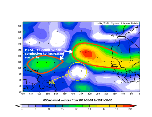
For easterly waves moving westward away from Africa, the MLAEJ (Mid-level African Easterly Jet) is an important factor in getting the wave to spin up. It is measured by 650 mb winds; the faster they are, the more vorticity at mid-levels which helps spin up an MLC. 93L has been in an area with almost no 600mb wind, but they will pick up markedly as the disturbance gets past 45-50 degrees west. (650mb is not a mandatory level so I used 600mb.)
0 likes
Re: ATL: INVEST 93L - Models
Ptarmigan wrote:http://raleighwx.americanwx.com/models/gfs/12zgfs500mbHGHTPMSLtropical288.gif
GFS 12 day model has 93L as a major hurricane hitting Upper Texas Coast. It is too early to tell at this time, but GFS +8 day has gotten it right in the past.
http://raleighwx.americanwx.com/models/ ... p24288.gif
24 hour rainfall total. Shows heavy rain.
Overall have these models in past runs displayed consistency?
0 likes
-
Portastorm

- Storm2k Moderator

- Posts: 9955
- Age: 63
- Joined: Fri Jul 11, 2003 9:16 am
- Location: Round Rock, TX
- Contact:
Re: ATL: INVEST 93L - Models
underthwx ... it is the GFS which is the main American medium-range computer model. This model and the European are considered the two major medium-range computer models. Your question is a very general one and a bit difficult to answer. The 0z run showed a major cane hitting Texas but further south on the coastline as compared to the 12z run. So, we have seen some consistency here.
If you keep following this thread ... trust me ... you will see every GFS run talked about and you can determine for yourself whether or not we have some consistency.
We have a lot of great members who will break down every model run. Just keep watching and reading.
If you keep following this thread ... trust me ... you will see every GFS run talked about and you can determine for yourself whether or not we have some consistency.
We have a lot of great members who will break down every model run. Just keep watching and reading.
0 likes
Any forecasts under my name are to be taken with a grain of salt. Get your best forecasts from the National Weather Service and National Hurricane Center.
Re: ATL : INVEST 93L - Discussion
ozonepete wrote:This is just one factor, but an important one:
For easterly waves moving westward away from Africa, the MLAEJ (Mid-level African Easterly Jet) is an important factor in getting the wave to spin up. It is measured by 650 mb winds; the faster they are, the more vorticity at mid-levels which helps spin up an MLC. 93L has been in an area with almost no 600mb wind, but they will pick up markedly as the disturbance gets past 45-50 degrees west. (650mb is not a mandatory level so I used 600mb.)
Nice. Very nice.
If I recall correctly, the causality here is horizontal wind shear (and related barotropic instability)--change in wind speed over horizontal distances that cause localized vorticity (...I THINK I have that right)...this is of course distinct from vertical wind shear--changes in wind speed with height.
Put simply the MLAEJ is a mid level jet formed over Africa due to temp differences between the Sahara and adjacent less-desert-y land areas. It deserves many more paragraphs because it is pretty darn cool!
The MLAEJ ought to be required reading for all the tropical weather lovers on the board, because without it, we don't get waves, and without the waves, the tropics are whole lot less interesting.
So, your forecast is for the invest to pick up mid level spin as it enters that more favorable MLAEJ area? Are you at all concerned about it staying on the cyclonic side of the jet?
Very nice.
0 likes
Re: ATL: INVEST 93L - Models
Portastorm wrote:underthwx ... it is the GFS which is the main American medium-range computer model. This model and the European are considered the two major medium-range computer models. Your question is a very general one and a bit difficult to answer. The 0z run showed a major cane hitting Texas but further south on the coastline as compared to the 12z run. So, we have seen some consistency here.
If you keep following this thread ... trust me ... you will see every GFS run talked about and you can determine for yourself whether or not we have some consistency.
We have a lot of great members who will break down every model run. Just keep watching and reading.
well said Portastorm......interesting that 18Z GFS has backed off similar to the 12Z EURO......
but look at this sucker at 384HR...

0 likes
Who is online
Users browsing this forum: No registered users and 39 guests