ATL : HARVEY - Tropical Depression - Discussion
Moderator: S2k Moderators
-
dwsqos2
-
SouthDadeFish

- Professional-Met

- Posts: 2835
- Joined: Thu Sep 23, 2010 2:54 pm
- Location: Miami, FL
- Contact:

-
SouthDadeFish
- Professional-Met
- Posts: 2835
- Joined: Thu Sep 23, 2010 2:54 pm
- Location: Miami, FL
- Contact:
-
Aric Dunn
- Category 5

- Posts: 21238
- Age: 43
- Joined: Sun Sep 19, 2004 9:58 pm
- Location: Ready for the Chase.
- Contact:
Re:
SouthDadeFish wrote:Judging by the ASCAT pass there a few spots with calm wind, and if I were a betting man, I bet recon would have found a few very light west winds.
exactly. someone correct if im wrong... but most scat data is prone to errors due rain contamination. I can see plenty of evidence for a closed surface circ.
0 likes
Note: If I make a post that is brief. Please refer back to previous posts for the analysis or reasoning. I do not re-write/qoute what my initial post said each time.
If there is nothing before... then just ask
Space & Atmospheric Physicist, Embry-Riddle Aeronautical University,
I believe the sky is falling...
If there is nothing before... then just ask
Space & Atmospheric Physicist, Embry-Riddle Aeronautical University,
I believe the sky is falling...
-
Aric Dunn
- Category 5
- Posts: 21238
- Age: 43
- Joined: Sun Sep 19, 2004 9:58 pm
- Location: Ready for the Chase.
- Contact:
Re: ATL : INVEST 93L - Discussion
wxman57 wrote:I don't think they're going to upgrade.
Unless they have some other data we cant see... I dont think they will either.. just because.
0 likes
Note: If I make a post that is brief. Please refer back to previous posts for the analysis or reasoning. I do not re-write/qoute what my initial post said each time.
If there is nothing before... then just ask
Space & Atmospheric Physicist, Embry-Riddle Aeronautical University,
I believe the sky is falling...
If there is nothing before... then just ask
Space & Atmospheric Physicist, Embry-Riddle Aeronautical University,
I believe the sky is falling...
-
SouthDadeFish
- Professional-Met
- Posts: 2835
- Joined: Thu Sep 23, 2010 2:54 pm
- Location: Miami, FL
- Contact:
Re: ATL : INVEST 93L - Discussion
wxman57 wrote:I don't think they're going to upgrade.
We have to see the progress over the next three hours. I find it hard to believe this won't be a TD by at least 11pm...
0 likes
-
wxman57

- Moderator-Pro Met

- Posts: 23173
- Age: 68
- Joined: Sat Jun 21, 2003 8:06 pm
- Location: Houston, TX (southwest)
Re: ATL : INVEST 93L - Discussion
SouthDadeFish wrote:wxman57 wrote:I don't think they're going to upgrade.
We have to see the progress over the next three hours. I find it hard to believe this won't be a TD by at least 11pm...
I didn't say it wasn't a TD, just that I didn't think they'd upgrade yet.
0 likes
-
SouthDadeFish
- Professional-Met
- Posts: 2835
- Joined: Thu Sep 23, 2010 2:54 pm
- Location: Miami, FL
- Contact:
Re: ATL : INVEST 93L - Discussion
wxman57 wrote:SouthDadeFish wrote:wxman57 wrote:I don't think they're going to upgrade.
We have to see the progress over the next three hours. I find it hard to believe this won't be a TD by at least 11pm...
I didn't say it wasn't a TD, just that I didn't think they'd upgrade yet.
I see. Well then I agree with you. Btw the 12Z GFDL really brought this thing north. Near the Belize/Mexico border.
0 likes
-
ozonepete
- Professional-Met
- Posts: 4743
- Joined: Mon Sep 07, 2009 3:23 pm
- Location: From Ozone Park, NYC / Now in Brooklyn, NY
Re: Re:
Aric Dunn wrote:SouthDadeFish wrote:Judging by the ASCAT pass there a few spots with calm wind, and if I were a betting man, I bet recon would have found a few very light west winds.
exactly. someone correct if im wrong... but most scat data is prone to errors due rain contamination. I can see plenty of evidence for a closed surface circ.
You are not wrong at all. You are quite right. ASCAT and its predecessor QuikScat have alot of errors due to rain contamination. Since they read winds near the surface based on the motion of sea spray and small water droplets, they can't "see" through heavy rain and produce bad data. Still a great tool, but it is not reliable once a CDO or considerable convection sets up.
0 likes
-
Aric Dunn
- Category 5
- Posts: 21238
- Age: 43
- Joined: Sun Sep 19, 2004 9:58 pm
- Location: Ready for the Chase.
- Contact:
Re: Re:
ozonepete wrote:Aric Dunn wrote:SouthDadeFish wrote:Judging by the ASCAT pass there a few spots with calm wind, and if I were a betting man, I bet recon would have found a few very light west winds.
exactly. someone correct if im wrong... but most scat data is prone to errors due rain contamination. I can see plenty of evidence for a closed surface circ.
You are not wrong at all. You are quite right. ASCAT and its predecessor QuikScat have alot of errors due to rain contamination. Since they read winds near the surface based on the motion of sea spray and small water droplets, they can't "see" through heavy rain and produce bad data. Still a great tool, but it is not reliable once a CDO or considerable convection sets up.
right I was much more familiar with quikscat, but never really read the differences between it and ASCAT.
0 likes
Note: If I make a post that is brief. Please refer back to previous posts for the analysis or reasoning. I do not re-write/qoute what my initial post said each time.
If there is nothing before... then just ask
Space & Atmospheric Physicist, Embry-Riddle Aeronautical University,
I believe the sky is falling...
If there is nothing before... then just ask
Space & Atmospheric Physicist, Embry-Riddle Aeronautical University,
I believe the sky is falling...
-
SouthDadeFish
- Professional-Met
- Posts: 2835
- Joined: Thu Sep 23, 2010 2:54 pm
- Location: Miami, FL
- Contact:

-
Aric Dunn
- Category 5
- Posts: 21238
- Age: 43
- Joined: Sun Sep 19, 2004 9:58 pm
- Location: Ready for the Chase.
- Contact:
Re:
HURAKAN wrote:18/1745 UTC 15.7N 80.5W T2.0/2.0 93L
30 knots
Thats right where I have it..
0 likes
Note: If I make a post that is brief. Please refer back to previous posts for the analysis or reasoning. I do not re-write/qoute what my initial post said each time.
If there is nothing before... then just ask
Space & Atmospheric Physicist, Embry-Riddle Aeronautical University,
I believe the sky is falling...
If there is nothing before... then just ask
Space & Atmospheric Physicist, Embry-Riddle Aeronautical University,
I believe the sky is falling...
-
jlauderdal
- S2K Supporter

- Posts: 7240
- Joined: Wed May 19, 2004 5:46 am
- Location: NE Fort Lauderdale
- Contact:
Re: ATL : INVEST 93L - Discussion
Miami NWS says only a tropical wave, whats the big deal... 
THE LONG RANGE MODELS
LINING UP AND AGREEING THAT A DEVELOPING TROPICAL WAVE APPROACHES
THE AREA LATE NEXT WEEK. AT THIS TIME...LOADING ECMWF WINDS AND
LEAVING WEATHER AS IS PENDING ADDITIONAL GUIDANCE/DEVELOPMENT.
THE LONG RANGE MODELS
LINING UP AND AGREEING THAT A DEVELOPING TROPICAL WAVE APPROACHES
THE AREA LATE NEXT WEEK. AT THIS TIME...LOADING ECMWF WINDS AND
LEAVING WEATHER AS IS PENDING ADDITIONAL GUIDANCE/DEVELOPMENT.
0 likes
-
ozonepete
- Professional-Met
- Posts: 4743
- Joined: Mon Sep 07, 2009 3:23 pm
- Location: From Ozone Park, NYC / Now in Brooklyn, NY
Re: ATL : INVEST 93L - Discussion
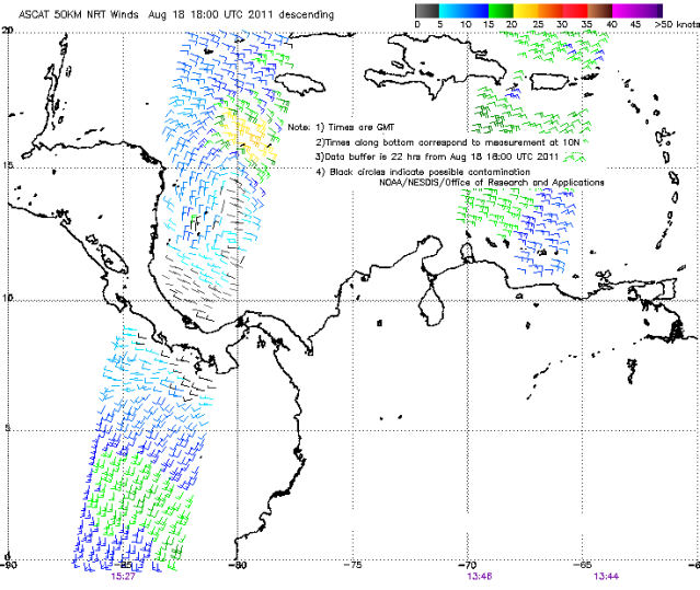
Aric, they're pretty much the same technique. ASCAT just takes smaller swaths unfortunately. Here's the original ASCAT pass from 18Z (from NOAA page) that shows where the rain contamination is (black barbs). Bear in mind that the orientation is often off by a number of miles, so don't concentrate on the circulation's position relative to where you see it on satellite. But notice where the center is, and how it couldn't read any of the winds on the south side of it. That is why I haven't used the EUMETSAT version yet - it's much more nicely presented, but I can't find where and how they deal with the contaminated readings. Their help function isn't very helpful. 
0 likes
-
wxman57
- Moderator-Pro Met
- Posts: 23173
- Age: 68
- Joined: Sat Jun 21, 2003 8:06 pm
- Location: Houston, TX (southwest)
Re: ATL : INVEST 93L - Discussion
Only 190nm to the coat of Honduras. That's 12 more hours over water unless it jogs northward.
0 likes
-
ozonepete
- Professional-Met
- Posts: 4743
- Joined: Mon Sep 07, 2009 3:23 pm
- Location: From Ozone Park, NYC / Now in Brooklyn, NY
Re: ATL : INVEST 93L - Discussion
jlauderdal wrote:Miami NWS says only a tropical wave, whats the big deal...
THE LONG RANGE MODELS
LINING UP AND AGREEING THAT A DEVELOPING TROPICAL WAVE APPROACHES
THE AREA LATE NEXT WEEK. AT THIS TIME...LOADING ECMWF WINDS AND
LEAVING WEATHER AS IS PENDING ADDITIONAL GUIDANCE/DEVELOPMENT.
That's a reference to 97L, not this one, isn't it?
0 likes
-
ozonepete
- Professional-Met
- Posts: 4743
- Joined: Mon Sep 07, 2009 3:23 pm
- Location: From Ozone Park, NYC / Now in Brooklyn, NY
Re: ATL : INVEST 93L - Discussion
wxman57 wrote:Only 190nm to the coat of Honduras. That's 12 more hours over water unless it jogs northward.
Isn't it about to slow down considerably?
0 likes
-
jlauderdal
- S2K Supporter
- Posts: 7240
- Joined: Wed May 19, 2004 5:46 am
- Location: NE Fort Lauderdale
- Contact:
Re: ATL : INVEST 93L - Discussion
ozonepete wrote:jlauderdal wrote:Miami NWS says only a tropical wave, whats the big deal...
THE LONG RANGE MODELS
LINING UP AND AGREEING THAT A DEVELOPING TROPICAL WAVE APPROACHES
THE AREA LATE NEXT WEEK. AT THIS TIME...LOADING ECMWF WINDS AND
LEAVING WEATHER AS IS PENDING ADDITIONAL GUIDANCE/DEVELOPMENT.
That's a reference to 97L, not this one, isn't it?
yep, my error
0 likes
Who is online
Users browsing this forum: No registered users and 147 guests