anyway that is how I see it....
Global model runs discussion
Moderator: S2k Moderators
Re: Global Model Runs Discussion
south of west trek with a huge ridge pushing this Pouch17 back closer to 10N, stays weak due SAL and forward speed ala 12Z EURO, into the lesser antilles as a TD....misses the connection with the trof pushing wnw thru the channel and slams into Texas relieving the worst drought since 1980.....
anyway that is how I see it....
anyway that is how I see it....
0 likes
Re: Global Model Runs Discussion
18Z NOGAPS on drugs again...
97L where are you? oh you have divided into 3 separate entities. nice...
https://www.fnmoc.navy.mil/wxmap_cgi/cg ... t=Tropical
97L where are you?
https://www.fnmoc.navy.mil/wxmap_cgi/cg ... t=Tropical
0 likes
- South Texas Storms
- Professional-Met

- Posts: 4260
- Joined: Thu Jun 24, 2010 12:28 am
- Location: Houston, TX
Re: Global Model Runs Discussion
ROCK wrote:south of west trek with a huge ridge pushing this Pouch17 back closer to 10N, stays weak due SAL and forward speed ala 12Z EURO, into the lesser antilles as a TD....misses the connection with the trof pushing wnw thru the channel and slams into Texas relieving the worst drought since 1980.....
anyway that is how I see it....
Rock, I love it. That's exactly how I see it as well.
0 likes
- South Texas Storms
- Professional-Met

- Posts: 4260
- Joined: Thu Jun 24, 2010 12:28 am
- Location: Houston, TX
Re: Global Model Runs Discussion
If there is no ridge, then couldn't the western gulf be a possibility as well?
0 likes
Re: Global Model Runs Discussion
See all that SAL / stable air this wave is bringing with it to the north. No wonder there is no convection....
My take as of right now on the GFS runs....The GFS still advertising over and over again the same place but we are still in the mid 200hrs. Not la la land but close. Lets not forget all the misses earlier in the year with the GFS showing sprinkles in the carib when we had a developing system.
93L had model support for a time as well....
0 likes
Re: Global Model Runs Discussion
South Texas Storms wrote:If there is no ridge, then couldn't the western gulf be a possibility as well?
yes...but we are still a long way out....almost 250hrs...
0 likes
- Meso
- Category 5

- Posts: 1609
- Age: 39
- Joined: Mon Aug 09, 2004 12:14 pm
- Location: South Africa
- Contact:
Re: Global Model Runs Discussion
The 00z CMC at 240 hours looking a lot like the previous GFS runs.


0 likes
Re: Global Model Runs Discussion
Meso wrote:The 00z CMC at 240 hours looking a lot like the previous GFS runs.
excepts it is on the wrong side of FL.....
interesting the CMC never closes this off until its under Hispa at 144hr.....stays a weak wave all the way across.
0 likes
Models still suggesting a TS coming off Africa and then slowly weakening in the E.Atlantic...rather odd thing to see but I do remember a xcouple of systems, I think Debby from 2006 for example, thast came off well developed and weakened in the E.Atlantic.
0 likes
Personal Forecast Disclaimer:
The posts in this forum are NOT official forecast and should not be used as such. They are just the opinion of the poster and may or may not be backed by sound meteorological data. They are NOT endorsed by any professional institution or storm2k.org. For official information, please refer to the NHC and NWS products
The posts in this forum are NOT official forecast and should not be used as such. They are just the opinion of the poster and may or may not be backed by sound meteorological data. They are NOT endorsed by any professional institution or storm2k.org. For official information, please refer to the NHC and NWS products
- cycloneye
- Admin

- Posts: 149520
- Age: 69
- Joined: Thu Oct 10, 2002 10:54 am
- Location: San Juan, Puerto Rico
Re:
KWT wrote:Models still suggesting a TS coming off Africa and then slowly weakening in the E.Atlantic...rather odd thing to see but I do remember a xcouple of systems, I think Debby from 2006 for example, thast came off well developed and weakened in the E.Atlantic.
Yes,it was Debby.

0 likes
Visit the Caribbean-Central America Weather Thread where you can find at first post web cams,radars
and observations from Caribbean basin members Click Here
and observations from Caribbean basin members Click Here
Comes off even further north then Debby, it'd be rare for such a well developed system to come off Africa and then poof right away...
0 likes
Personal Forecast Disclaimer:
The posts in this forum are NOT official forecast and should not be used as such. They are just the opinion of the poster and may or may not be backed by sound meteorological data. They are NOT endorsed by any professional institution or storm2k.org. For official information, please refer to the NHC and NWS products
The posts in this forum are NOT official forecast and should not be used as such. They are just the opinion of the poster and may or may not be backed by sound meteorological data. They are NOT endorsed by any professional institution or storm2k.org. For official information, please refer to the NHC and NWS products
Re:
KWT wrote:Models still suggesting a TS coming off Africa and then slowly weakening in the E.Atlantic...rather odd thing to see but I do remember a xcouple of systems, I think Debby from 2006 for example, thast came off well developed and weakened in the E.Atlantic.
Are you talking about what the GFS & ECMWF have been persistent on for the last few days of a strong tropical wave come out of Africa late weekend or early next week with a very well defined circulation and low surface pressures well before it exits Africa?
I have been looking at that too, but if the GFS iis right in it exiting in such a high latitude, the SSTs north of the C.V. Islands are below 26 deg C all the way back to almost 35W, so it might be the reason why they show it to eventually die out some as it exits the coast.
Meanwhile the Euro shows a little farther south track closer to the C.V. Islands and it holds it a little bit longer as a T.S.
0 likes
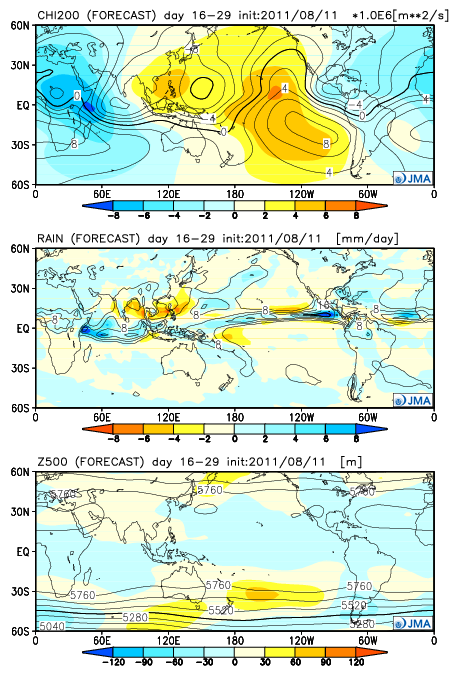
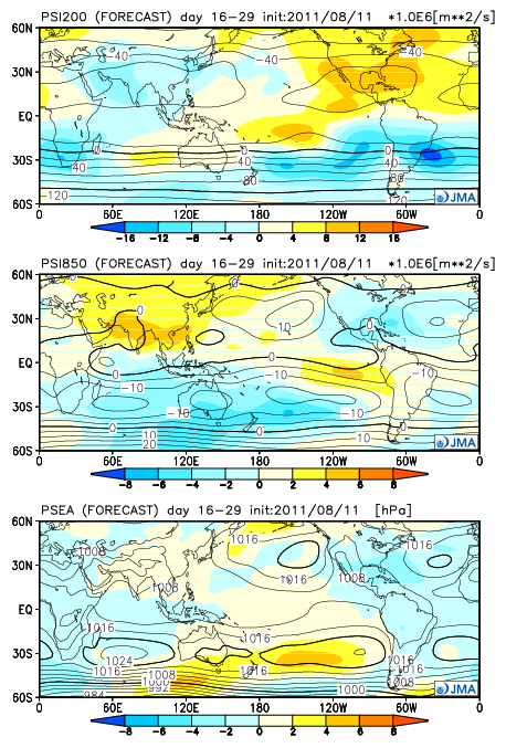
In case nobody has posted, the JAM concensus model monthly forecast is agreeing with the EUROSIP model of a busy period in the Atlantic coming up, it also shows that the ridging across the central US will be winding down and troughing in the eastern US will be flattening out by the end of the month/early September time period.


0 likes
-
HurricaneFan
- Tropical Storm

- Posts: 192
- Age: 42
- Joined: Tue Jan 18, 2011 6:16 pm
- Location: Anguilla,Leeward Islands 18.3N 63.0W
Re: Global Model Runs Discussion
So are the models doing anything with the Tropical Wave just off the coast of Africa?
0 likes
- somethingfunny
- ChatStaff

- Posts: 3926
- Age: 37
- Joined: Thu May 31, 2007 10:30 pm
- Location: McKinney, Texas
Re: Global Model Runs Discussion
I'm not seeing any chatter about this. The models seem to be indicating not just Harvey (93L) and Irene (97L) soon, but also Jose and Katia. In fact, one or both of them could be classified before 97L if the 12z GFS is correct.
Neither one of them lasts long on the model run, but they're there nonetheless:
GFS

Euro

Another quickie surprise frontal development?

Wave exiting Africa

And look at how 97L has completely purged the Eastern Atlantic of dry air.
Neither one of them lasts long on the model run, but they're there nonetheless:
GFS

Euro

Another quickie surprise frontal development?

Wave exiting Africa

And look at how 97L has completely purged the Eastern Atlantic of dry air.
0 likes
I am not a meteorologist, and any posts made by me are not official forecasts or to be interpreted as being intelligent. These posts are just my opinions and are probably silly opinions.
- somethingfunny
- ChatStaff

- Posts: 3926
- Age: 37
- Joined: Thu May 31, 2007 10:30 pm
- Location: McKinney, Texas
Never mind, I found the SAL. 

Still a really nice looking wave with a good environment. I wonder why the models don't like it to be long-lived. The really potent Cape Verde storm the models show in about 96-120 hours is the wave behind this one.

Still a really nice looking wave with a good environment. I wonder why the models don't like it to be long-lived. The really potent Cape Verde storm the models show in about 96-120 hours is the wave behind this one.
0 likes
I am not a meteorologist, and any posts made by me are not official forecasts or to be interpreted as being intelligent. These posts are just my opinions and are probably silly opinions.
- somethingfunny
- ChatStaff

- Posts: 3926
- Age: 37
- Joined: Thu May 31, 2007 10:30 pm
- Location: McKinney, Texas
Re: Global Model Runs Discussion
Just for kicks. GFS in 11 days has a major hurricane on Houston's doorstep. I can't put much stock on it.


0 likes
Re: Global Model Runs Discussion
Ptarmigan wrote:Just for kicks. GFS in 11 days has a major hurricane on Houston's doorstep. I can't put much stock on it.
If this were to happen (just saying and wondering), what would be the strength of something like this as shown on this model?
0 likes
Who is online
Users browsing this forum: No registered users and 23 guests


