ATL: IRENE - Models
Moderator: S2k Moderators
-
OuterBanker
- S2K Supporter

- Posts: 1761
- Joined: Wed Feb 26, 2003 10:53 am
- Location: Nags Head, NC
- Contact:
Re: ATL: INVEST 97L-Models
I know it's a different thread. But it could affect 97L's name. 98L went code orange. Could become a monster fish.
0 likes
Re: ATL: INVEST 97L-Models
18z DGEX model has 97L over the Keys heading up the west coast of Florida
http://www.emc.ncep.noaa.gov/mmb/mmbpll/dgexops.conus/
http://www.emc.ncep.noaa.gov/mmb/mmbpll/dgexops.conus/
0 likes
-
otowntiger
- Category 5

- Posts: 1932
- Joined: Tue Aug 31, 2004 7:06 pm
Re: ATL: INVEST 97L-Models
[quote="Ivanhater"]18z GFS Ensembles show SE Louisana and heading north
and not nearly as strong as previously advertised. Like I've said before, if we think predicting the direction is like guess work, then intensity forecasts are like playing darts blindfolded with no hands.
and not nearly as strong as previously advertised. Like I've said before, if we think predicting the direction is like guess work, then intensity forecasts are like playing darts blindfolded with no hands.
0 likes
-
TwisterFanatic

- Category 5
- Posts: 1041
- Joined: Mon Jun 28, 2010 12:43 pm
- Location: Sallisaw, Oklahoma
Re: ATL: INVEST 97L-Models
otowntiger wrote:Ivanhater wrote:18z GFS Ensembles show SE Louisana and heading north
and not nearly as strong as previously advertised. Like I've said before, if we think predicting the direction is like guess work, then intensity forecasts are like playing darts blindfolded with no hands.
You don't look at intensity on the ensembles..
0 likes
Personal Forecast Disclaimer:
The posts in this forum are NOT official forecast and should not be used as such. They are just the opinion of the poster and may or may not be backed by sound meteorological data. They are NOT endorsed by any professional institution or storm2k.org. For official information, please refer to the NHC and NWS products.
The posts in this forum are NOT official forecast and should not be used as such. They are just the opinion of the poster and may or may not be backed by sound meteorological data. They are NOT endorsed by any professional institution or storm2k.org. For official information, please refer to the NHC and NWS products.
-
Blown Away

- S2K Supporter
- Posts: 10253
- Joined: Wed May 26, 2004 6:17 am
Re: ATL: INVEST 97L-Models

Well this will throw a wrench in the west trend thinking, the NHC hugging 00z TVCN shows what looks like a recurve through the Bahamas.
0 likes
Hurricane Eye Experience: David 79, Irene 99, Frances 04, Jeanne 04, Wilma 05… Hurricane Brush Experience: Andrew 92, Erin 95, Floyd 99, Matthew 16, Irma 17, Ian 22, Nicole 22…
-
South Texas Storms

- Professional-Met

- Posts: 4257
- Joined: Thu Jun 24, 2010 12:28 am
- Location: Houston, TX
Re: ATL: INVEST 97L-Models
Why haven't the GFDL and HWRF models been run yet for this system?
0 likes
-
Rgv20

- S2K Supporter
- Posts: 2466
- Age: 39
- Joined: Wed Jan 05, 2011 5:42 pm
- Location: Edinburg/McAllen Tx
I took a close look at the guidance this evening and to put it bluntly they are all over the place in regards to 97l track. 18zGFS Ensembles track 97L anywhere from the Western Gulf to the East Coast and the 12zECMWF Ensembles are on the same boat as the GFS Ensembles. Bottom line interest in the Yucatan, Texas, Central Gulf Coast, Florida, East Coast need to keep an eye on it. (I tried my hardest to narrow it down...lol)
On a side note the ECMWF Ensemble Control Run has 97L tracking thru the West coast of Florida and the ECMWF Monthly Forecast release today has the track just to the East of Florida eventually making landfall in South Carolina on Saturday Night August 27.
18zGFS Ensembles Valid for Sunday August 28. Dark colors represent where 97L may end up.
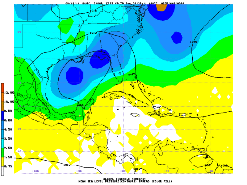
12zECMWF Ensembles Valid for Sunday August 28. 97L could be anywhere in the Gulf Of Mexico to the East coast of the US.
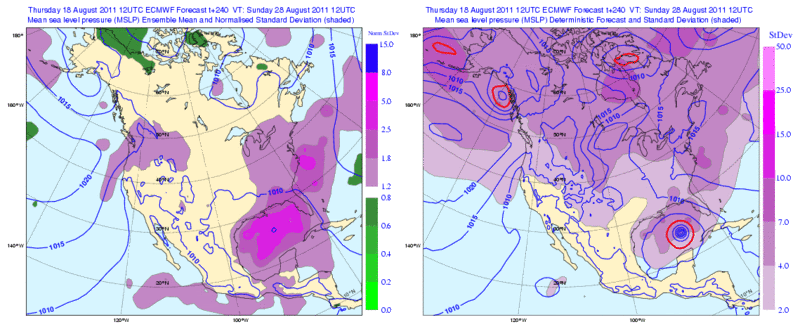
On a side note the ECMWF Ensemble Control Run has 97L tracking thru the West coast of Florida and the ECMWF Monthly Forecast release today has the track just to the East of Florida eventually making landfall in South Carolina on Saturday Night August 27.
18zGFS Ensembles Valid for Sunday August 28. Dark colors represent where 97L may end up.
12zECMWF Ensembles Valid for Sunday August 28. 97L could be anywhere in the Gulf Of Mexico to the East coast of the US.
0 likes
The following post is NOT an official forecast and should not be used as such. It is just the opinion of the poster and may or may not be backed by sound meteorological data. It is NOT endorsed by any professional institution including storm2k.org For Official Information please refer to the NHC and NWS products.

-
OuterBanker
- S2K Supporter
- Posts: 1761
- Joined: Wed Feb 26, 2003 10:53 am
- Location: Nags Head, NC
- Contact:
Re:
OuterBanker wrote:Wha happened, it was going to Houston couple hours ago
That was the GFS model.....the TVCN is a blend of all the models...the only reason I think is because of the BAMS and Nogaps, like gator stated
0 likes
-
weatherguy2
- Tropical Depression

- Posts: 72
- Joined: Sun Aug 01, 2010 2:45 am
Re:
gatorcane wrote:So how is the consensus track (TVCN) so far east?
Do the deep BAM and NOGAPS carry that much weight?
It's the average of at least 2 of several models, and only two are available now. One being the interpolated NOGAPS which is way east, so that's why there was a east turn of the TVCN.
0 likes

00Z NAM rolling in..H+66 strenghening as it passes near Guadeloupe...
http://www.nco.ncep.noaa.gov/pmb/nwprod ... p_066l.gif
http://www.nco.ncep.noaa.gov/pmb/nwprod ... p_066l.gif
0 likes
H+72 00Z NAM moving thru Northen leeward islands...
http://www.nco.ncep.noaa.gov/pmb/nwprod ... p_072l.gif
http://www.nco.ncep.noaa.gov/pmb/nwprod ... p_072l.gif
0 likes
-
wxman57

- Moderator-Pro Met

- Posts: 23174
- Age: 68
- Joined: Sat Jun 21, 2003 8:06 pm
- Location: Houston, TX (southwest)
Re:
gatorcane wrote:So how is the consensus track (TVCN) so far east?
Do the deep BAM and NOGAPS carry that much weight?
NOGAPS is the last model I'd ever look at. It's almost always forecasting the exact opposite of what a TC actually ends up doing. BAM models are non-dynamic trajectory models. They shouldn't be used outside of the deep tropics (like south of 20N).
0 likes
H72 00z NAM...most agresive run thus far
500mb:
http://www.nco.ncep.noaa.gov/pmb/nwprod ... 0_072l.gif
500mb:
http://www.nco.ncep.noaa.gov/pmb/nwprod ... 0_072l.gif
0 likes
-
South Texas Storms
- Professional-Met
- Posts: 4257
- Joined: Thu Jun 24, 2010 12:28 am
- Location: Houston, TX
Re: ATL: INVEST 97L-Models
0z Nam tonight looks too strong and too far north. It almost takes it north of Puerto Rico on this run.
0 likes
00Z NAM 500mb Loop...In fact, looking at the synoptics it makes complete sense..Most worrisome would be the fact it would miss most significant land interaction and would probablly be a powerhouse as it entered the bahamas....
Loop 500MB
http://www.nco.ncep.noaa.gov/pmb/nwprod ... loop.shtml
Loop 500MB
http://www.nco.ncep.noaa.gov/pmb/nwprod ... loop.shtml
0 likes
200mb at H+84 indicates a very favorable pattern for strengthening...
http://www.nco.ncep.noaa.gov/pmb/nwprod ... 0_084l.gif
http://www.nco.ncep.noaa.gov/pmb/nwprod ... 0_084l.gif
0 likes
Who is online
Users browsing this forum: No registered users and 8 guests