ATL: IRENE - Remnants - Discussion

Moderator: S2k Moderators

Message
Author
User avatar
Hurricaneman
Category 5
Category 5
Posts: 7351
Age: 45
Joined: Tue Aug 31, 2004 3:24 pm
Location: central florida

Re: ATL: INVEST 97L - Discussion

#301 Postby Hurricaneman » Fri Aug 19, 2011 1:08 pm

Frank2 wrote:
ENVIRONMENTAL CONDITIONS ARE EXPECTED TO GRADUALLY BECOME MORE CONDUCIVE...


Get out the garden shears - another hedge system (LOL)...

Frank


Essentially, they're not saying things aren't conducive for development, that things will become better farther west
0 likes   

User avatar
ConvergenceZone
Category 5
Category 5
Posts: 5194
Joined: Fri Jul 29, 2005 1:40 am
Location: Northern California

Re: ATL: INVEST 97L - Discussion

#302 Postby ConvergenceZone » Fri Aug 19, 2011 1:11 pm

Frank2 wrote:
ENVIRONMENTAL CONDITIONS ARE EXPECTED TO GRADUALLY BECOME MORE CONDUCIVE...


Get out the garden shears - another hedge system (LOL)...

Frank


40% IS ACTUALLY REALLY GOOD.....I didn't except this to have convection as early as it has. This tells me that it's
already starting to slowly get its act together....It should be up to %60 by tomorrow if not higher.
0 likes   

Frank2
Category 5
Category 5
Posts: 4061
Joined: Mon Jul 25, 2005 12:47 pm

Re: ATL: INVEST 97L - Discussion

#303 Postby Frank2 » Fri Aug 19, 2011 1:15 pm

Perhaps, but so far this season we've seen system after system that is very slow in getting organized - but never does much more than that...

Sure, these are the CV systems that have more potential, but if the environment isn't just right then it's origin doesn't matter...

In seeing the WV I'm sticking with the opinion that the ULL/TUTT environment ahead of it really isn't very suitable for development...

Frank
0 likes   

User avatar
Gustywind
Category 5
Category 5
Posts: 12334
Joined: Mon Sep 03, 2007 7:29 am
Location: Baie-Mahault, GUADELOUPE

#304 Postby Gustywind » Fri Aug 19, 2011 1:19 pm

000
AXNT20 KNHC 191758
TWDAT

TROPICAL WEATHER DISCUSSION
NWS NATIONAL HURRICANE CENTER MIAMI FL
205 PM EDT FRI AUG 19 2011

TROPICAL WEATHER DISCUSSION FOR NORTH AMERICA...CENTRAL
AMERICA...GULF OF MEXICO...CARIBBEAN SEA...NORTHERN SECTIONS OF
SOUTH AMERICA...AND ATLANTIC OCEAN TO THE AFRICAN COAST FROM THE
EQUATOR TO 32N. THE FOLLOWING INFORMATION IS BASED ON SATELLITE
IMAGERY...WEATHER OBSERVATIONS...RADAR...AND METEOROLOGICAL
ANALYSIS.

BASED ON 1200 UTC SURFACE ANALYSIS AND SATELLITE IMAGERY
THROUGH 1715 UTC.

...SPECIAL FEATURE...


ANOTHER WELL-DEFINED WAVE IS IN THE CENTRAL TRPCL ATLC ALONG
17N48W TO 9N47W WITH CYCLONIC FLOW CONCENTRATED ALONG THE AXIS
AROUND A 1006 MB LOW NEAR 13N. THIS SYSTEM IS MOVING W NEAR 20
KT. CONVECTION NEAR THE WAVE HAS INCREASED OVER THE PAST 24
HOURS. CURRENTLY NUMEROUS MODERATE/SCATTERED STRONG CONVECTION
IS MAINLY W OF THE WAVE FROM 13N-17N BETWEEN 47W-53W...AND SE OF
THE AXIS FROM 6N-9N BETWEEN 42W-47W. UPPER LEVEL CONDITIONS ARE
EXPECTED TO BECOME MORE CONDUCIVE FOR FURTHER DEVELOPMENT OVER
THE NEXT COUPLE OF DAYS
.
0 likes   

tolakram
Admin
Admin
Posts: 20009
Age: 62
Joined: Sun Aug 27, 2006 8:23 pm
Location: Florence, KY (name is Mark)

Re: ATL: INVEST 97L - Discussion

#305 Postby tolakram » Fri Aug 19, 2011 1:21 pm

These spread out developing waves probably do more overall damage in rainfall than an organized tropical storm does. Islands should prepare for yet another deluge of rain and flooding ... again. In my opinion.

Personal Forecast Disclaimer:
The posts in this forum are NOT official forecast and should not be used as such. They are just the opinion of the poster and may or may not be backed by sound meteorological data. They are NOT endorsed by any professional institution or storm2k.org. For official information, please refer to the NHC and NWS products.
0 likes   
M a r k
- - - - -
Join us in chat: Storm2K Chatroom Invite. Android and IOS apps also available.

The posts in this forum are NOT official forecasts and should not be used as such. Posts are NOT endorsed by any professional institution or STORM2K.org. For official information and forecasts, please refer to NHC and NWS products.

User avatar
Gustywind
Category 5
Category 5
Posts: 12334
Joined: Mon Sep 03, 2007 7:29 am
Location: Baie-Mahault, GUADELOUPE

#306 Postby Gustywind » Fri Aug 19, 2011 1:22 pm

19/1745 UTC 13.2N 49.0W TOO WEAK 97L
19/1145 UTC 13.6N 47.3W TOO WEAK 97L
0 likes   

User avatar
HurricaneMaster_PR
Category 2
Category 2
Posts: 795
Joined: Tue Jul 22, 2003 6:23 pm
Location: San Juan, Puerto Rico

Re: ATL: INVEST 97L - Discussion

#307 Postby HurricaneMaster_PR » Fri Aug 19, 2011 1:24 pm

TAFB foresees a more northerly track than indicated by the GFS model, in terms that the system should put PR at risk...

Image
0 likes   

Caribwxgirl
S2K Supporter
S2K Supporter
Posts: 287
Joined: Mon Aug 15, 2011 7:25 pm
Location: Budapest, Hungary (from Kingston, Jamaica)

Re: ATL: INVEST 97L - Discussion

#308 Postby Caribwxgirl » Fri Aug 19, 2011 1:28 pm

Is the season getting exciting yet? :)
0 likes   
Personal Forecast Disclaimer:
The posts in this forum are NOT official forecast. They are just the opinion of the poster and may or may not be backed by sound meteorological data. They are NOT endorsed by any professional institutions or storm2k.org. For official information refer to the NHC and NWS products.

User avatar
Gustywind
Category 5
Category 5
Posts: 12334
Joined: Mon Sep 03, 2007 7:29 am
Location: Baie-Mahault, GUADELOUPE

#309 Postby Gustywind » Fri Aug 19, 2011 1:31 pm

This thing continues to expanding in size in spite of the dry air in vicinity of its huge enveloppe of moisture. Convection seems on the increase since the last 3 hours.
Image
0 likes   

User avatar
Blown Away
S2K Supporter
S2K Supporter
Posts: 10145
Joined: Wed May 26, 2004 6:17 am

Re: ATL: INVEST 97L - Discussion

#310 Postby Blown Away » Fri Aug 19, 2011 1:31 pm

HurricaneMaster_PR wrote:TAFB foresees a more northerly track than indicated by the GFS model, in terms that the system should put PR at risk...

Image


More NW to PR then WSW back under Hispaniola? Crazy, ridge pushing 97L around!
0 likes   
Hurricane Eye Experience: David 79, Irene 99, Frances 04, Jeanne 04, Wilma 05... EYE COMING MY WAY IN 2024…
Hurricane Brush Experience: Andrew 92, Erin 95, Floyd 99, Matthew 16, Irma 17, Ian 22, Nicole 22…

ozonepete
Professional-Met
Professional-Met
Posts: 4743
Joined: Mon Sep 07, 2009 3:23 pm
Location: From Ozone Park, NYC / Now in Brooklyn, NY

Re: ATL: INVEST 97L - Discussion

#311 Postby ozonepete » Fri Aug 19, 2011 1:37 pm

Man, this is really getting going. Impressive change to much better symmetry and big convective blowup and nice outflow.

Image

Image
0 likes   

User avatar
Macrocane
Category 5
Category 5
Posts: 4218
Age: 36
Joined: Sun May 24, 2009 5:35 pm
Location: El Salvador

Re: ATL: INVEST 97L - Discussion

#312 Postby Macrocane » Fri Aug 19, 2011 1:42 pm

It's looking better by the hour, sure it has to fight the dry air but if the mid level wind shear is not that high it won't affect it much.
0 likes   

canes04
Category 1
Category 1
Posts: 302
Joined: Sat May 22, 2004 5:41 pm
Location: Miami, FL

Re: ATL: INVEST 97L - Discussion

#313 Postby canes04 » Fri Aug 19, 2011 1:43 pm

keep an eye on the area near 14.8 & 49.
0 likes   

User avatar
northjaxpro
S2K Supporter
S2K Supporter
Posts: 8900
Joined: Mon Sep 27, 2010 11:21 am
Location: Jacksonville, FL

#314 Postby northjaxpro » Fri Aug 19, 2011 1:45 pm

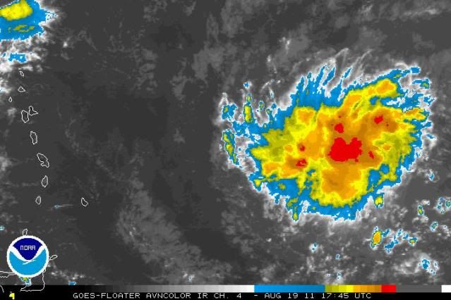
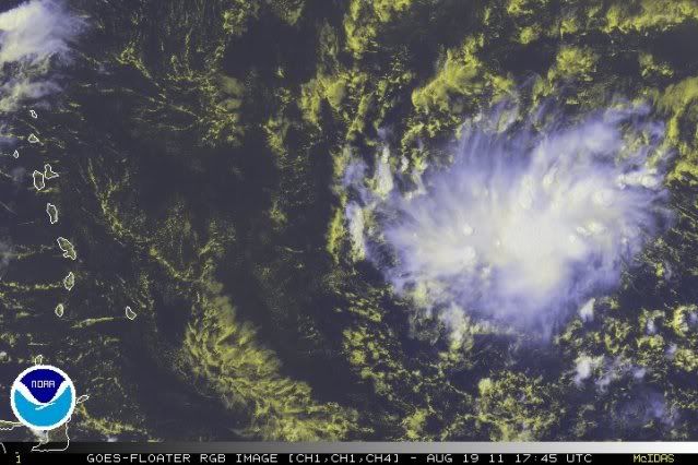
Indeed, 97L is looking much better compared to even six hours ago. It seems that 97L has moistened the environment just enough, at least for the time being, to shield against that dry air that had impeded it earlier. We will have to see if this trend with the convection continues or at least sustains going into the evening.
0 likes   
NEVER, EVER SAY NEVER in the tropics and weather in general, and most importantly, with life itself!!

________________________________________________________________________________________

Fay 2008 Beryl 2012 Debby 2012 Colin 2016 Hermine 2016 Julia 2016 Matthew 2016 Irma 2017 Dorian 2019

User avatar
CourierPR
Category 5
Category 5
Posts: 1335
Age: 71
Joined: Tue Aug 31, 2004 7:53 pm
Location: Pompano Beach, Florida

Re: ATL: INVEST 97L - Discussion

#315 Postby CourierPR » Fri Aug 19, 2011 1:54 pm

Frank2 wrote:Perhaps, but so far this season we've seen system after system that is very slow in getting organized - but never does much more than that...

Sure, these are the CV systems that have more potential, but if the environment isn't just right then it's origin doesn't matter...

In seeing the WV I'm sticking with the opinion that the ULL/TUTT environment ahead of it really isn't very suitable for development...

Frank


Apparently the meteorologists at the NHC disagree with you.
0 likes   

Aric Dunn
Category 5
Category 5
Posts: 21238
Age: 42
Joined: Sun Sep 19, 2004 9:58 pm
Location: Ready for the Chase.
Contact:

#316 Postby Aric Dunn » Fri Aug 19, 2011 1:58 pm

It appears to be becoming more organized faster than I thought it would today. The low level inflow to the S through E has continued to improve with distinct cloud lines. Al there is a increased easterly motion to the low level could just south of the convection. and the last few hours there is a decent mid level circ right were the deep convection is. Convection is maintaining and becoming more concentrated. Still needs to continue for it ro develop before the islands.

best chance for something to tighten up seems to be around 15N 51 W
0 likes   
Note: If I make a post that is brief. Please refer back to previous posts for the analysis or reasoning. I do not re-write/qoute what my initial post said each time.
If there is nothing before... then just ask :)

Space & Atmospheric Physicist, Embry-Riddle Aeronautical University,
I believe the sky is falling...

User avatar
BatzVI
Tropical Storm
Tropical Storm
Posts: 199
Joined: Sat Jun 10, 2006 8:27 am
Location: St. Thomas, Virgin Islands

Re: ATL: INVEST 97L - Discussion

#317 Postby BatzVI » Fri Aug 19, 2011 2:01 pm

"Still needs to continue for it ro develop before the islands."

Personally, I'd rather it not develop.....!
0 likes   

User avatar
CourierPR
Category 5
Category 5
Posts: 1335
Age: 71
Joined: Tue Aug 31, 2004 7:53 pm
Location: Pompano Beach, Florida

Re: ATL: INVEST 97L - Discussion

#318 Postby CourierPR » Fri Aug 19, 2011 2:05 pm

Bastardi tweets that 97L (Irene) will be a Florida threat.
Last edited by CourierPR on Fri Aug 19, 2011 2:08 pm, edited 1 time in total.
0 likes   

Aric Dunn
Category 5
Category 5
Posts: 21238
Age: 42
Joined: Sun Sep 19, 2004 9:58 pm
Location: Ready for the Chase.
Contact:

Re: ATL: INVEST 97L - Discussion

#319 Postby Aric Dunn » Fri Aug 19, 2011 2:06 pm

pressure falling pretty fast at the next buoy in its path ... still over a hundred miles from it pressure has probably dropped more... say 1005mb

Image
0 likes   
Note: If I make a post that is brief. Please refer back to previous posts for the analysis or reasoning. I do not re-write/qoute what my initial post said each time.
If there is nothing before... then just ask :)

Space & Atmospheric Physicist, Embry-Riddle Aeronautical University,
I believe the sky is falling...

User avatar
cycloneye
Admin
Admin
Posts: 145295
Age: 68
Joined: Thu Oct 10, 2002 10:54 am
Location: San Juan, Puerto Rico

Re: ATL: INVEST 97L - Discussion

#320 Postby cycloneye » Fri Aug 19, 2011 2:07 pm

CourierPR wrote:Bastardi tweets that Irene will be a Florida threat.


So he thinks this will form first than 98L?
0 likes   
Visit the Caribbean-Central America Weather Thread where you can find at first post web cams,radars
and observations from Caribbean basin members Click Here


Return to “2011”

Who is online

Users browsing this forum: No registered users and 5 guests