ConvergenceZone wrote:So now the question is, depression sometime tomorrow? or holding off until Sunday?
Recon will have the answer tommorow afternoon.
Moderator: S2k Moderators


ConvergenceZone wrote:So now the question is, depression sometime tomorrow? or holding off until Sunday?

ConvergenceZone wrote:So now the question is, depression sometime tomorrow? or holding off until Sunday?
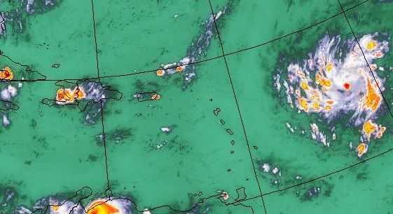
cycloneye wrote:Look at that white pop in the middle.


wxman57 wrote:Quite impressive now. Development chances next 48 hours at least 80%.
Gustywind wrote:msbee wrote:Gustywind wrote:97L
http://www.ssd.noaa.gov/goes/flt/t2/ir4.jpg
Gusty
that looks like it is heading right at you.
what does Meteo. FR say? any watches yet?
Waouw, Barbara, looks like.. view on this forward angle and you're may be right?. Since yesterday it seems at Guadeloupe could be one of the most island who may feel the "possible effects"of this feature?! Like you and our other friends in the Carib islands we SHOULD continue to watch it carefully hoping that he won't track in our area. You're right concerning Meteo-France, they have already issued an yellow alert (a watch for strong showers/ tstorms but not a watch Cyclone) for Guadeloupe, Martinica and...the Northen Leewards for a risk of strong showers and tstorms. If current increasing trend continues then we could eventually see another colors maybe tommorow, but that's another story and the one i hope we won't deal with. Don't let your guard down Barbara, it's too early to know if a particular island could be directly impacted. Let's wait and see.


gatorcane wrote:wxman57 wrote:Quite impressive now. Development chances next 48 hours at least 80%.
Wxman, do you think the LLC is trying to form further north under the MLC, near 15N?

jlauderdal wrote:cycloneye wrote:Look at that white pop in the middle.
hot tower alert
TreasureIslandFLGal wrote:what does it look like the overall size of this system will be? Will it be compact like Charley was, or huge like Jeanne was? Hopefully not Flloyd size.
Katrina was so big that even though she was only a Cat 3 at landfall, her surge was liek a much bigger storm.
ozonepete wrote:gatorcane wrote:wxman57 wrote:Quite impressive now. Development chances next 48 hours at least 80%.
Wxman, do you think the LLC is trying to form further north under the MLC, near 15N?
I hope he says yes. It sure looks like it to me. And it wouldn't be the first time the models and other evidence were wrong.
wxman57 wrote:ozonepete wrote:Looks that way to me, but I wouldn't think it'll make THAT much difference way down the road. I still think it's looking more like it may pass west of the FL Peninsula. How far west? I'll tell you next week.


Users browsing this forum: No registered users and 73 guests


