See how the juicy convection is spreading on Guadeloupe bringing already showers and tstorms on us... and more is to come folks! One word this year in Guadeloupe rain rain rain this

Moderator: S2k Moderators


msbee wrote:Gustywind wrote:HUC wrote:Meteo Guadeloupe put a center near 13,8N 58W and an Orange alert for our territories.
The weather is overcast( cirrostratus and alto stratus ) with Cb clouds, passing rain and strong thunder...Things are beginin folks...Stay tunes and be prepared!
Thanks for you report HUC. The same here in my locality. Looking at the radar of Meteo-France squalls lines are not so far from our island! Let's continue to monitor carefully 97L approaching pretty closely now...
keep us updated Gusty and HUC.
we are keeping a close outlook here also. so far sunny skies.
 Be safe and dry Msbee, we continue to monitor closely the situation.
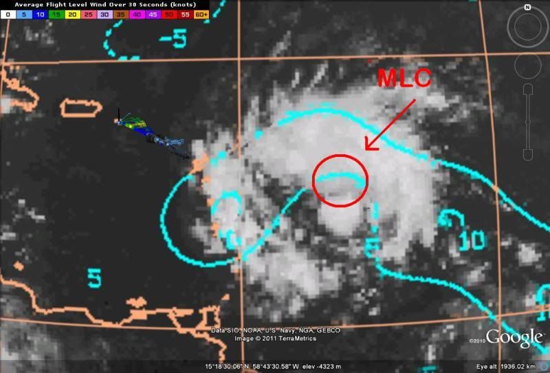
NDG wrote:I still see a lot of easterly winds south of the MLC.
I still think that a closed LLC may not develop until tonight or early tomorrow morning at the earliest, if it enters the Caribbean without a closed circulation it may not close it until it slows down after feeling the weakness to its NW by day 3.


000
FXUS62 KTBW 201740
AFDTBW
AREA FORECAST DISCUSSION
NATIONAL WEATHER SERVICE TAMPA BAY RUSKIN FL
140 PM EDT SAT AUG 20 2011
.LONG TERM (MONDAY NIGHT - SATURDAY)...
A FAIRLY TYPICAL AND RATHER SIMPLISTIC SYNOPTIC PATTERN IS EXPECTED
TO BECOME MUCH MORE COMPLEX BY THE TAIL END OF THE PERIOD. A WEAK
MID/UPPER LEVEL PATTERN WITH THE SURFACE RIDGE AXIS JUST NORTH OF
TAMPA BAY WILL HELP MAINTAIN A GENERAL EASTERLY FLOW PATTERN
THOUGH MUCH OF WEEK. EXPECTING TYPICAL SUMMERTIME CONDITIONS OF
SCATTERED AFTERNOON THUNDERSTORMS PUSHING INLAND ALONG THE SEA
BREEZE. HAVE MAINTAIN 30/40 POPS THROUGH MUCH OF THE PERIOD. HIGH
UNCERTAINTY REMAINS FOR THE LAST PERIOD OF THE LONG TERM. MODELS
ARE SOMEWHAT CONSISTENT WITH SHOWING A TROPICAL SYSTEM APPROACHING
THE PENINSULA BY FRIDAY. BECAUSE OF THE HIGH UNCERTAINTY...WILL
WAIT TO ADJUST THE FORECAST UNTIL THE SYSTEM TAKES BETTER SHAPE
WITH BETTER SYNOPTIC CONSISTENCY FROM THE MODELS.


wxman57 wrote:It's definitely not as far north as 15N, as a buoy at 14.8N/56.2W has an east wind at 20 kts. LLC looks too disorganized for classification today. Doubt it will make hurricane strength before Cuba. No guarantee it will be a hurricane if/when it reaches Florida if it spends so much time over land as the latest GFS is suggesting.
Adoquín wrote:wnw to me, or the effort at llc formation continues to play tricks on our perception. in any event we are going to be drenched in rain.

Users browsing this forum: No registered users and 54 guests