ATL: IRENE - Remnants - Discussion
Moderator: S2k Moderators
-
HurricaneMaster_PR

- Category 2

- Posts: 795
- Joined: Tue Jul 22, 2003 6:23 pm
- Location: San Juan, Puerto Rico
-
Dave

- Retired Staff

- Posts: 13442
- Age: 75
- Joined: Tue Aug 01, 2006 3:57 pm
- Location: Milan Indiana
- Contact:

0 likes
This post is NOT AN OFFICIAL FORECAST and should not be used as such. It is just the opinion of the poster and may or may not be backed by sound meteorological data. It is NOT endorsed by any professional institution including storm2k.org. For Official Information please refer to the NHC and NWS products.
-
Gustywind

- Category 5

- Posts: 12334
- Joined: Mon Sep 03, 2007 7:29 am
- Location: Baie-Mahault, GUADELOUPE
Re: ATL: IRENE - Tropical Storm - Discussion
HurricaneMaster_PR wrote:ST Croix is really feeling it right now!
You're may be right HurricaneMaster...
News from ours neighbours of Ste Croix...
http://stormcarib.com/reports/current/stcroix.shtml
- Updates from the Islands -
- - St.Croix (USVI) - -
- BLOWING!!!
•By Susan Beck <sbeckchef1 at yahoo.com>
•Date: Sun, 21 Aug 2011 16:40:34 -0700 (PDT)
Well, just hung up with the husband and he is doing fine. We still have dish network, cell fone and WAPA! WOW! I am not sure about the internet though since he shut his computer down when the first power surge came thru at about 2pm. WAPA has been on the majority of the day. He said it has gone out about 3 times, but came back on within minutes.
I told him according to all of the maps he should be inthe thick of things right about now. He said yes, the winds are there and are blowing out of the east at about 35 - 40 with higher gusts coming through. He said not much rain all day until when I called and it just started dumping buckets outside and blowing into the hurricane shutters. Thank gosh he put those up, he did that at about 5pm when I told him he is going to be in for a rough few hours and he was thankful for putting them up he said or we would have had water in the house. At about 6pm he saw a few kite surfers out in front of the Divi taking advantage of the wind. Yikes, that is kind of scary to be out in that kind of weather.
Well, so far so good on the East End. 1 kitty cat stayed on the balcony to ride out the storm, smart kitty! Hubby felt sorry for him a nd gave him a can of WET cat food. Hoping the rest of our feral cat colony is hunkered down for the night somewhere safe.
Stay Safe everyone. I apologize for not being on island to provide pictures or video. Only word of mouth this time.
Susan
0 likes
-
painkillerr
- S2K Supporter

- Posts: 129
- Age: 70
- Joined: Wed Aug 25, 2010 5:17 pm
- Location: San Juan, PR
Re: ATL: IRENE - Tropical Storm - Discussion
Yikes! The blades of the two fans in our balcony are ripping off one at a time. Unbelievable!! New fans for the balcony I guess!
0 likes

Re: ATL: IRENE - Tropical Storm - Discussion
Pigsnibble wrote:I still think the Asymetry of the system is telling us something. Although the system is wrapping up nicely, something is allowing massive convection to the north and northeast.
I think it's because the anticyclone over it is stronger in the northern part, I'm not a pro so I could be misreading this image:

0 likes
-
Jevo

- S2K Supporter
- Posts: 1729
- Age: 47
- Joined: Tue Aug 03, 2004 8:45 pm
- Location: The Flemish Cap
- Contact:
The latest models are a beautiful thing here for me Turn baby Turn!!!! Out to sea preferably.. The one thing Ive learned over the years is that if your a direct hit at the end of the forecast period.. Hold off putting the shutters up.. I saw my house here in Fort Laud in the position this morning.. and if models hold true.. my theory is still going to hold true
Oh and just so I dont get flamed.. If you're anywhere in the cone always be alert and pay attention to local and state authorities. Make sure your hurricane plan is ready to go and dont sink your patio furniture in the pool.. and all that other good advice
VVVV Disclaimer below VVVV
Oh and just so I dont get flamed.. If you're anywhere in the cone always be alert and pay attention to local and state authorities. Make sure your hurricane plan is ready to go and dont sink your patio furniture in the pool.. and all that other good advice
VVVV Disclaimer below VVVV
0 likes
Disclaimer: 50% of the time I have no clue of what I am talking about. Chances are I am taking a less than educated guess that sounds good because 10 years ago I stole Mike Watkins book 'The Hurricane and its Impact'. For official information please direct yourself to the NHC and their cadre of weather geniuses.
-
Evil Jeremy

- S2K Supporter
- Posts: 5463
- Age: 32
- Joined: Mon Apr 10, 2006 2:10 pm
- Location: Los Angeles, CA
Someone else please take over:
000
URNT15 KNHC 220039
AF302 0309A IRENE HDOB 16 20110822
002900 1659N 06412W 8433 01563 0096 +163 +151 181028 028 032 006 00
002930 1658N 06411W 8433 01562 0096 +164 +150 178030 031 031 005 00
003000 1657N 06409W 8434 01563 0096 +165 +152 177031 032 031 006 00
003030 1656N 06408W 8430 01567 0099 +160 +156 177030 030 030 006 00
003100 1655N 06407W 8428 01572 0101 +160 +153 181029 030 028 003 00
003130 1654N 06406W 8436 01563 0100 +164 +152 184029 029 026 001 00
003200 1653N 06405W 8430 01569 0101 +165 +151 189029 029 025 001 00
003230 1652N 06404W 8434 01567 0101 +165 +149 188029 029 025 000 00
003300 1651N 06402W 8434 01567 0100 +165 +148 189028 029 024 000 00
003330 1650N 06401W 8432 01571 0101 +165 +149 189028 028 024 000 00
003400 1649N 06400W 8433 01570 0101 +169 +143 188028 028 024 000 00
003430 1648N 06359W 8433 01571 0100 +170 +143 188028 029 024 000 00
003500 1647N 06358W 8435 01569 0102 +170 +145 186026 027 023 001 00
003530 1646N 06356W 8429 01576 0104 +169 +144 188025 025 022 000 00
003600 1645N 06355W 8436 01568 0103 +170 +152 188026 027 022 001 00
003630 1644N 06354W 8432 01572 0105 +165 +156 187025 026 022 000 00
003700 1643N 06353W 8434 01572 0105 +163 +159 187025 026 021 000 00
003730 1642N 06352W 8436 01571 0106 +166 +154 185028 029 020 000 00
003800 1641N 06350W 8432 01575 0105 +166 +160 189027 028 017 001 00
003830 1640N 06349W 8435 01572 0106 +165 //// 187027 027 017 000 01
$$
;
0 likes
Frances 04 / Jeanne 04 / Katrina 05 / Wilma 05 / Fay 08 / Debby 12 / Andrea 13 / Colin 16 / Hermine 16 / Matthew 16 / Irma 17
-
Dave
- Retired Staff
- Posts: 13442
- Age: 75
- Joined: Tue Aug 01, 2006 3:57 pm
- Location: Milan Indiana
- Contact:

Go for it Macrocane....I'll keep going on graphics & other items.
0 likes
This post is NOT AN OFFICIAL FORECAST and should not be used as such. It is just the opinion of the poster and may or may not be backed by sound meteorological data. It is NOT endorsed by any professional institution including storm2k.org. For Official Information please refer to the NHC and NWS products.
Re: ATL: IRENE - Tropical Storm - Discussion
This is not like Floyd at all, in response to Joe B., Floyd was barreling west north of the islands before turning to the wnw then nw. Very different setup. 
0 likes
-
Evil Jeremy
- S2K Supporter
- Posts: 5463
- Age: 32
- Joined: Mon Apr 10, 2006 2:10 pm
- Location: Los Angeles, CA
Re:
Jevo wrote:The one thing Ive learned over the years is that if your a direct hit at the end of the forecast period.. Hold off putting the shutters up.. I saw my house here in Fort Laud in the position this morning.. and if models hold true.. my theory is still going to hold true
Oh and just so I dont get flamed.. If you're anywhere in the cone always be alert and pay attention to local and state authorities. Make sure your hurricane plan is ready to go and dont sink your patio furniture in the pool.. and all that other good advice
VVVV Disclaimer below VVVV
While you don't need to put your shutters up yet, SFL is no longer at the end of the forecast cone. Were within 4 days. If when you wake up in the morning, and SFL is still in the cone, thats about 3 1/2 days away, and time to seriously start getting ready.
Problem is, ever since Ike missed us, many people I know are more hesistant to prepare for big threats, not wanting to go through the entire preparation process again when the system might miss.
0 likes
Frances 04 / Jeanne 04 / Katrina 05 / Wilma 05 / Fay 08 / Debby 12 / Andrea 13 / Colin 16 / Hermine 16 / Matthew 16 / Irma 17
People it is really blowing here in Old San Juan facing east. You can tell the storm is strenghtening just by the sound of that wind increasingly howling. My greatest fear is it is slowing down in forward speed. 10 inches of rain was the last I read. if it verifies, it will be a disaster. Some plsnts just blew down at my terrace. Have not posted all day because of preps. We are down to the last details. Power is already getting unstable. I will try to post some pictures I took earlier, should Irene permit. All other folks in Puerto Rico, do not underestimate the puch of a strenghtening storm. Remember Marilyn. And be safe.
0 likes
-
Dave
- Retired Staff
- Posts: 13442
- Age: 75
- Joined: Tue Aug 01, 2006 3:57 pm
- Location: Milan Indiana
- Contact:
CORRECTED VDM OB 3
000
URNT12 KNHC 220031 CCA
VORTEX DATA MESSAGE AL092011
A. 22/00:05:00Z
B. 17 deg 51 min N
065 deg 01 min W
C. 850 mb 1383 m
D. 50 kt
E. 279 deg 19 nm
F. 040 deg 58 kt
G. 294 deg 37 nm
H. 994 mb
I. 16 C / 1524 m
J. 20 C / 1520 m
K. 18 C / NA
L. NA
M. NA
N. 12345 / 8
O. 0.02 / 3 nm
P. AF302 0309A IRENE OB 03 CCA
MAX FL WIND 58 KT NW QUAD 23:52:40Z
MAX FL TEMP 21 C 273 / 10 NM FROM FL CNTR
;
0 likes
-
HurricaneBelle

- S2K Supporter
- Posts: 1209
- Joined: Sun Aug 27, 2006 6:12 pm
- Location: Clearwater, FL
Re: Re:
Evil Jeremy wrote:Jevo wrote:The one thing Ive learned over the years is that if your a direct hit at the end of the forecast period.. Hold off putting the shutters up.. I saw my house here in Fort Laud in the position this morning.. and if models hold true.. my theory is still going to hold true
Oh and just so I dont get flamed.. If you're anywhere in the cone always be alert and pay attention to local and state authorities. Make sure your hurricane plan is ready to go and dont sink your patio furniture in the pool.. and all that other good advice
VVVV Disclaimer below VVVV
While you don't need to put your shutters up yet, SFL is no longer at the end of the forecast cone. Were within 4 days. If when you wake up in the morning, and SFL is still in the cone, thats about 3 1/2 days away, and time to seriously start getting ready.
Problem is, ever since Ike missed us, many people I know are more hesistant to prepare for big threats, not wanting to go through the entire preparation process again when the system might miss.
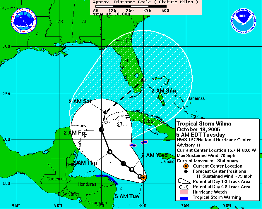
You'd think people in SFL would be respectful of the 5-day track since Wilma went there just as predicted (albeit a day later due to getting hung up near Cozumel):
0 likes
-
vbhoutex

- Storm2k Executive

- Posts: 29149
- Age: 74
- Joined: Wed Oct 09, 2002 11:31 pm
- Location: Cypress, TX
- Contact:
Re: Re:
Evil Jeremy wrote:Jevo wrote:The one thing Ive learned over the years is that if your a direct hit at the end of the forecast period.. Hold off putting the shutters up.. I saw my house here in Fort Laud in the position this morning.. and if models hold true.. my theory is still going to hold true
Oh and just so I dont get flamed.. If you're anywhere in the cone always be alert and pay attention to local and state authorities. Make sure your hurricane plan is ready to go and dont sink your patio furniture in the pool.. and all that other good advice
VVVV Disclaimer below VVVV
While you don't need to put your shutters up yet, SFL is no longer at the end of the forecast cone. Were within 4 days. If when you wake up in the morning, and SFL is still in the cone, thats about 3 1/2 days away, and time to seriously start getting ready.
Problem is, ever since Ike missed us, many people I know are more hesistant to prepare for big threats, not wanting to go through the entire preparation process again when the system might miss.
I hate to hear that!! I have always been with the "better safe than sorry" group.
Irene, imo, is still a toughy to figure out. At this point anyone from S FL to the Carolinas needs to be following her every move. Even some of the E GOM areas need to at least have one eye on Irene. As we all know timing is everything. Model consensus or not, If I lived anywhere from the FL panhandle to the Carolinas I would be concerned, not paniced, just concerned.
0 likes
Skywarn, C.E.R.T.
Please click below to donate to STORM2K to help with the expenses of keeping the site going:

Please click below to donate to STORM2K to help with the expenses of keeping the site going:
Re: ATL: IRENE - Recon
000
URNT15 KNHC 220049
AF302 0309A IRENE HDOB 17 20110822
003900 1639N 06348W 8433 01573 0105 +166 //// 186025 025 019 000 01
003930 1638N 06347W 8431 01574 0105 +166 //// 187023 024 018 000 01
004000 1637N 06346W 8432 01576 0106 +165 //// 183021 021 016 001 01
004030 1636N 06344W 8434 01572 0105 +167 +166 183022 023 016 001 00
004100 1635N 06343W 8428 01580 //// +152 //// 190021 022 028 010 01
004130 1634N 06342W 8447 01560 0104 +157 //// 184024 026 021 006 01
004200 1633N 06341W 8428 01578 0107 +167 +161 186024 026 021 000 00
004230 1632N 06340W 8432 01581 0109 +170 +147 184023 024 017 000 03
004300 1632N 06338W 8429 01581 0112 +165 +158 176024 025 /// /// 03
004330 1634N 06339W 8441 01566 0106 +168 +151 174024 024 016 000 03
004400 1636N 06339W 8432 01574 0105 +170 +151 176024 025 014 000 00
004430 1638N 06339W 8432 01576 0106 +169 +154 177024 024 015 000 00
004500 1640N 06340W 8433 01575 0106 +167 //// 179024 025 016 000 01
004530 1642N 06340W 8431 01576 0108 +163 //// 178025 026 018 000 01
004600 1643N 06340W 8437 01570 0107 +164 //// 177024 025 017 000 01
004630 1645N 06340W 8432 01574 0107 +165 +163 173025 025 018 000 00
004700 1647N 06341W 8433 01573 0107 +165 //// 173027 028 018 000 01
004730 1649N 06341W 8433 01573 0105 +166 +163 172028 029 021 000 00
004800 1651N 06341W 8432 01575 0107 +165 //// 171027 027 020 000 01
004830 1653N 06341W 8429 01576 0107 +162 //// 173027 027 020 001 01
$$
;
0 likes
-
stormhunter7

- Category 2
- Posts: 763
- Joined: Mon May 26, 2008 3:13 pm
- Location: Panama City Beach, Florida
- Contact:
Re: ATL: IRENE - Recon Discussion
Cudos to the guys tonight on that launch! only 15 Miles NW of Island was the COC.. wow, that had to be an crazy crosswind coming of the water and a quick crabb out to alt!

0 likes
The following post is NOT an official forecast and should not be used as such. It is just the opinion of the poster and may or may not be backed by sound meteorological data. It is NOT endorsed by any professional institution including storm2k.org For Official Information please refer to the NHC and NWS products. http://www.nhc.noaa.gov
-
Battlebrick
- Tropical Storm

- Posts: 177
- Joined: Thu Sep 02, 2010 9:55 pm
Re: ATL: IRENE - Tropical Storm - Discussion
NE quad is very strong right now, I want recon to go into it!
0 likes
Lim_Fao on IRC.
The following post is NOT an official forecast and should not be used as such. It is just the opinion of the poster and may or may not be backed by sound meteorological data. It is NOT endorsed by any professional institution including storm2k.org. For Official Information please refer to the NHC and NWS products.
The following post is NOT an official forecast and should not be used as such. It is just the opinion of the poster and may or may not be backed by sound meteorological data. It is NOT endorsed by any professional institution including storm2k.org. For Official Information please refer to the NHC and NWS products.

-
Hurricane Mac

- Tropical Low

- Posts: 15
- Age: 40
- Joined: Sat Aug 18, 2007 7:33 pm
- Location: Sumter, SC
- Contact:
Re: ATL: IRENE - Tropical Storm - Discussion
Steve H. wrote:This is not like Floyd at all, in response to Joe B., Floyd was barreling west north of the islands before turning to the wnw then nw. Very different setup.
I agree with you that this is a different set-up, but it is getting the look with models and NHC track to possibly put the entire Eastern Seaboard from the Keys to Hatteras under a watch or warning, and I think that may be what JB is talking about.
Last edited by Hurricane Mac on Sun Aug 21, 2011 7:59 pm, edited 1 time in total.
0 likes
I am no meteorologist, but I did study it at the University of Miami for 3 years before changing majors, so take everything with a ton of salt and believe just about nothing that I say. Check with the NHC and the pros for official predictions.
Who is online
Users browsing this forum: No registered users and 32 guests